#wvltfirstalert search results

Ummm excuse me @wvlt you scared (excited? 🤔) my hubby this morning with this alert. 🤭🤭. #wvltfirstalert #head #heatalert

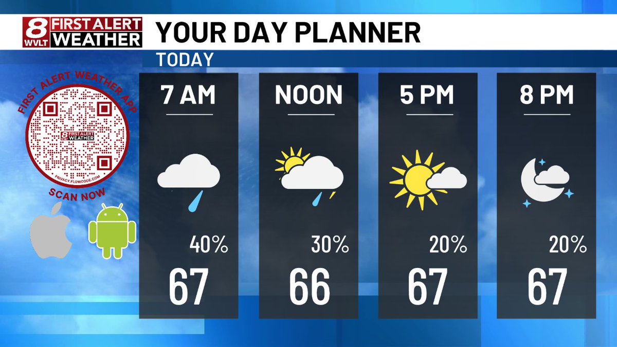
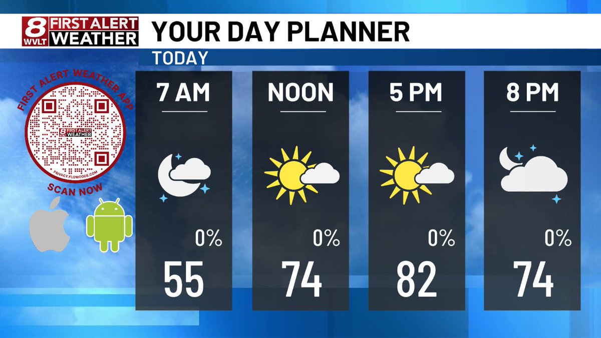
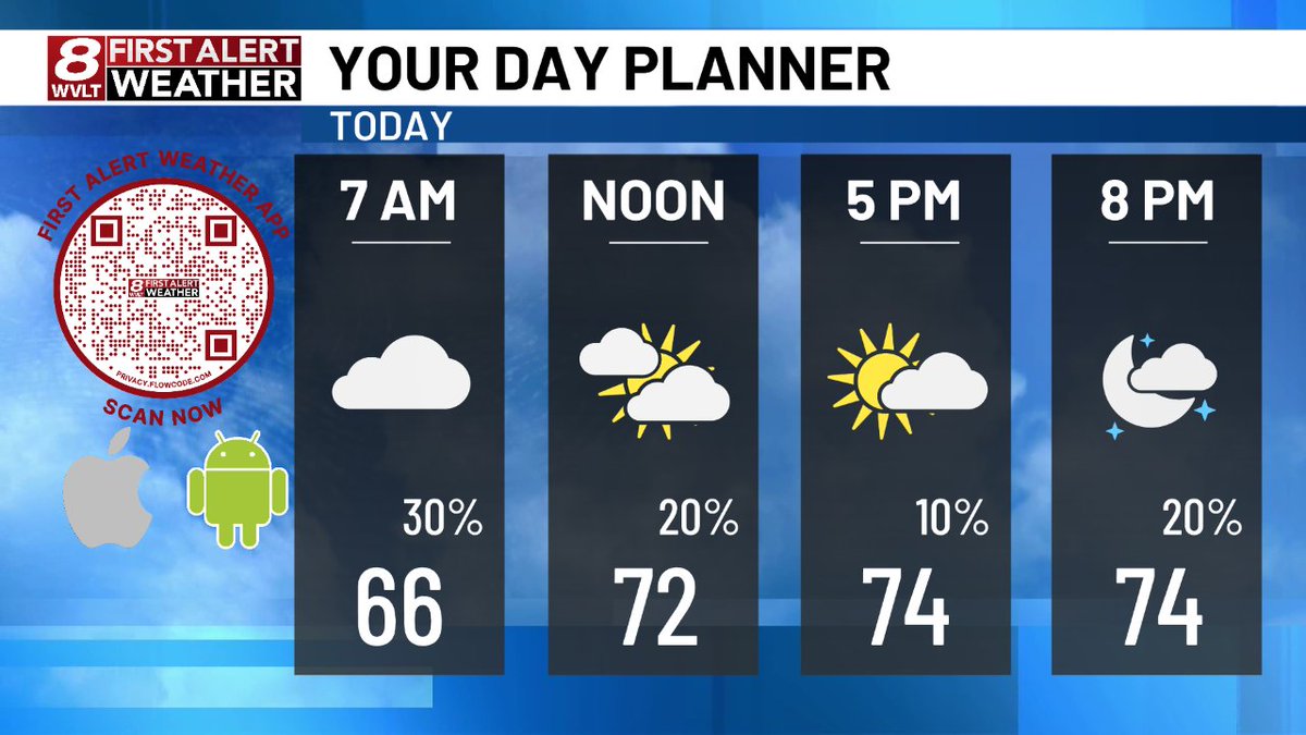
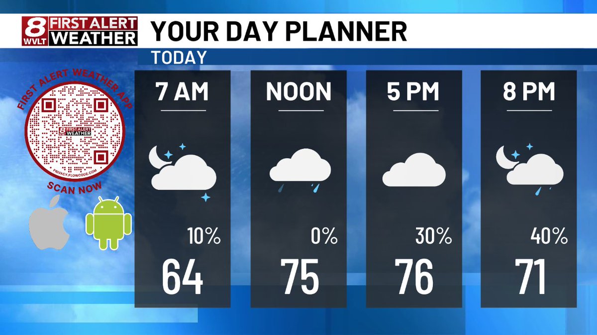
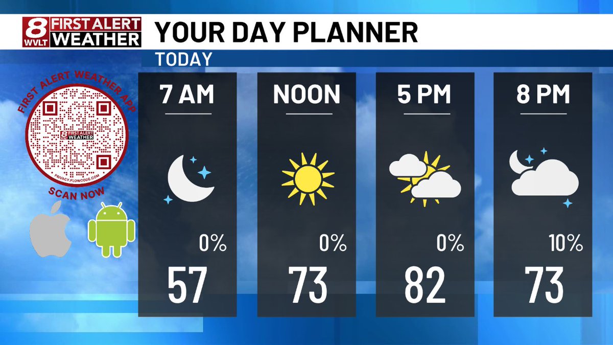
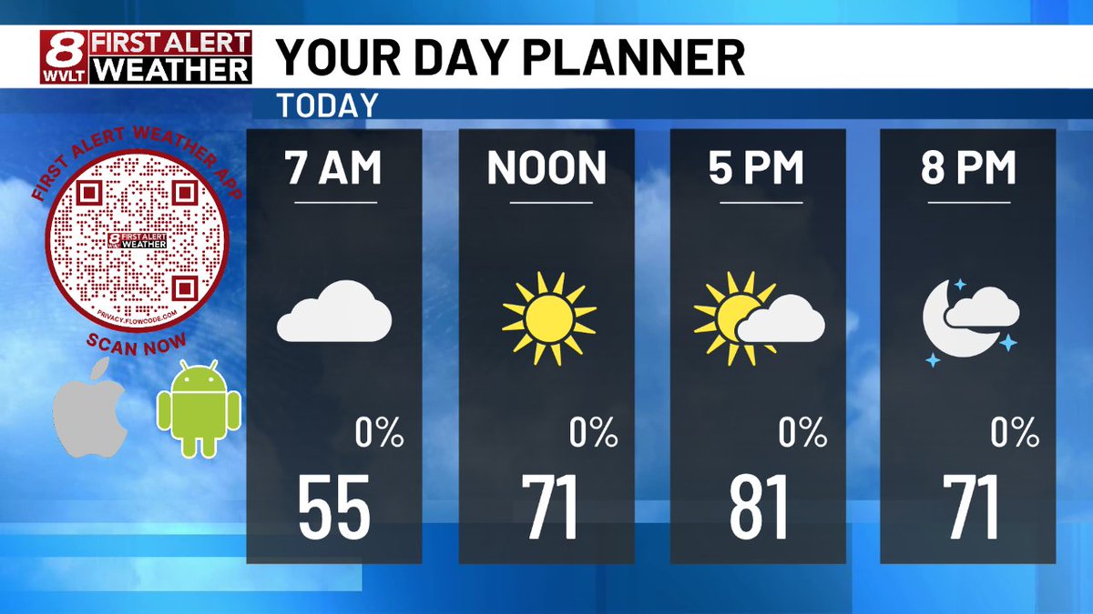
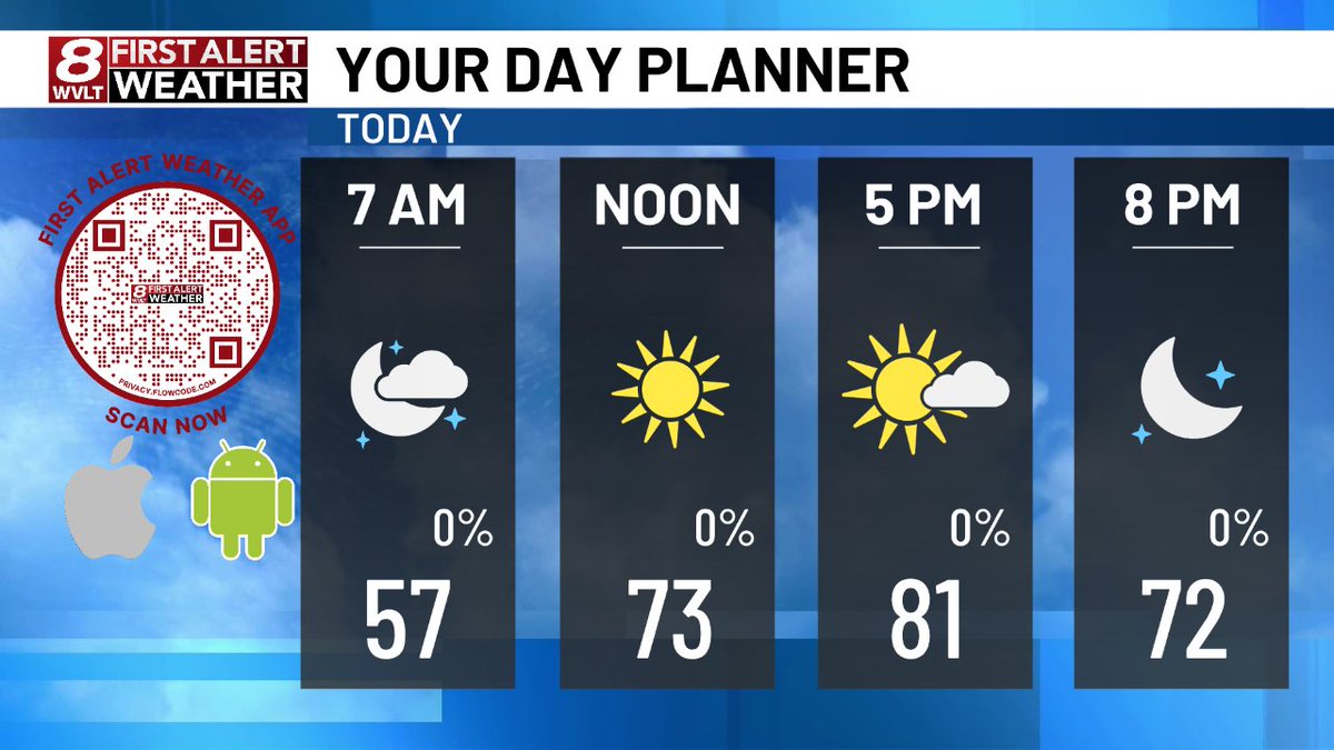
Here's a quick look at today's planner. Join us on @wvlt for your First Alert Forecast! wvlt.tv/weather #WVLTFirstAlert
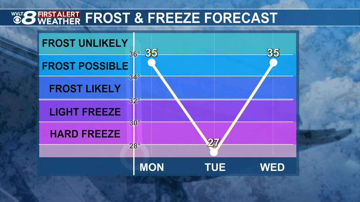
The National Weather Service issued a Frost Advisory. Find details on the forecast where you live in the free WVLT First Alert Weather app or on wvlt.tv/weather. #WVLTFirstAlert #Frost

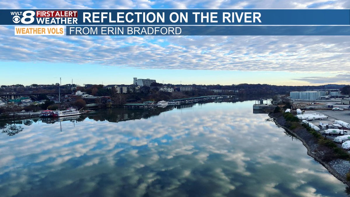
Are we looking at a mirror or the Tennessee River? Check out the cool view from Erin Bradford from the Gay Street Bridge. A perfect mirror image of the clouds on a slick calm day. #tnwx #wvltwx #WVLTFirstAlert
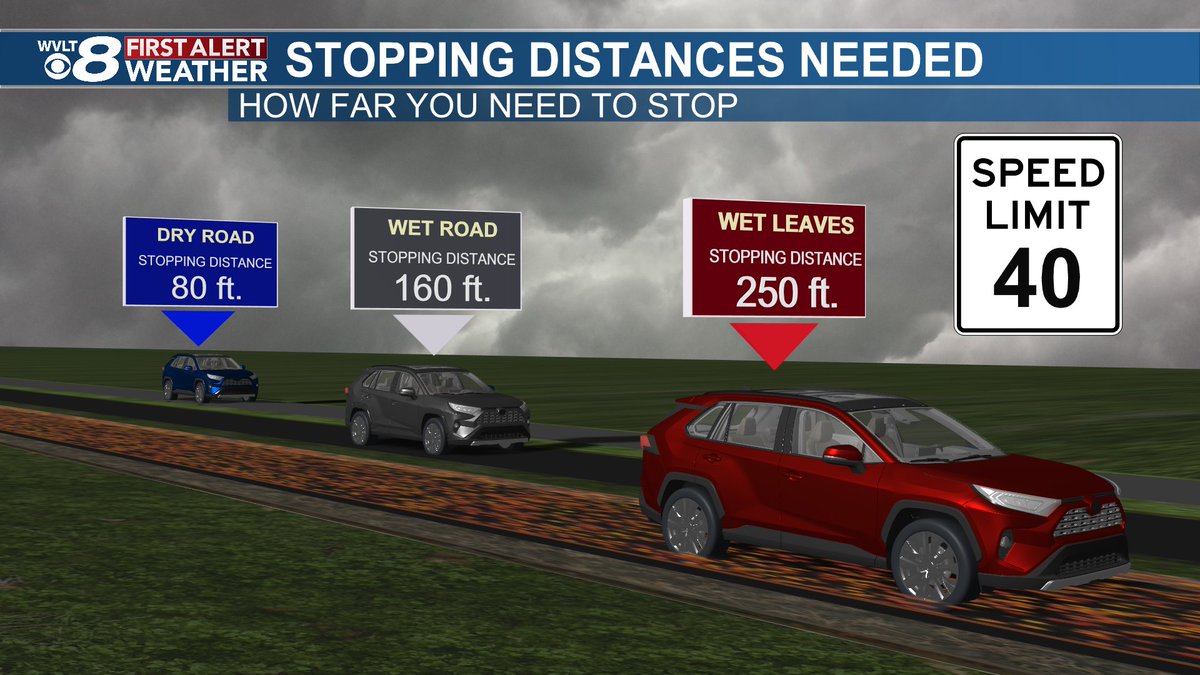
Much needed rainfall is on the way over the next 24 hours, but a good reminder to drive with caution on the roadways, especially with wet leaves. Here's a look at the stopping distances if you're traveling at 40 mph. #WVLTFirstAlert #tnwx #wvltwx
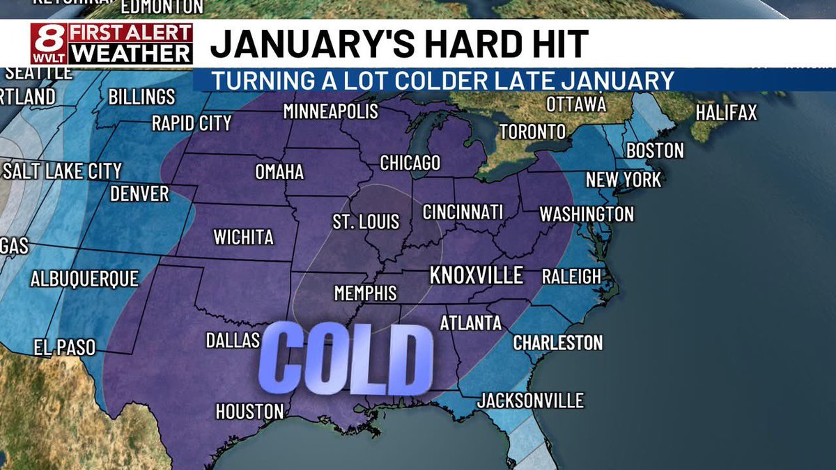
ANOTHER ARCTIC SURGE EARLY NEXT WEEK! More arctic air returns Monday through Wednesday behind this weekend’s cold front! (Jan 20-22nd) HOW COLD? Teens and 20s with single digit wind chills. #WVLTFirstAlert #Brrr
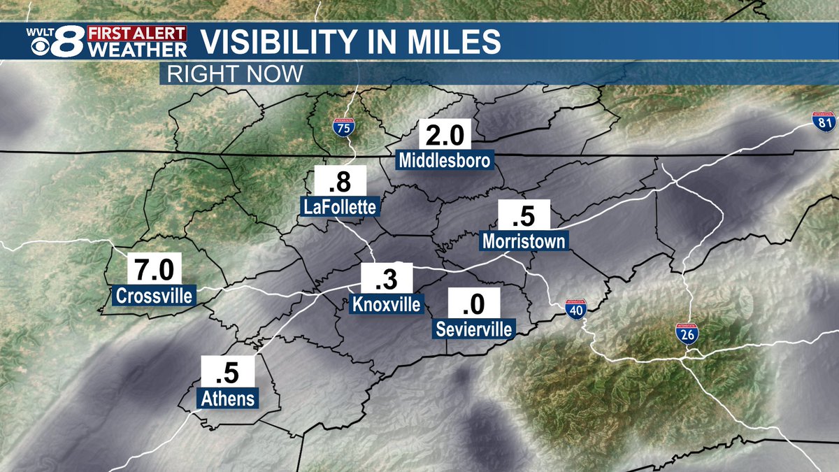
Good Saturday morning! We're tracking areas of dense fog to start the day. Take it slow as you head out the door with many areas under a mile visibility at times. We're tracking additional rain chances on WVLT News this morning at 7 a.m. #wvltfirstalert #tnwx #wvltwx

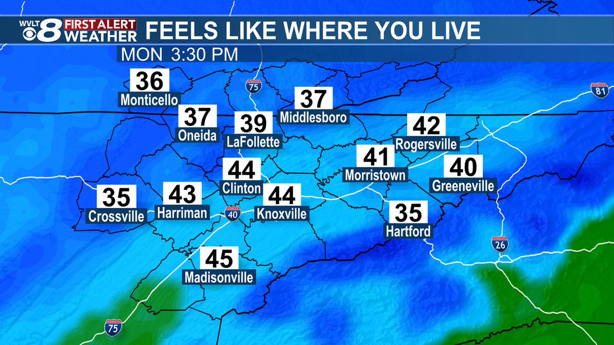
Get ready for big changes! Colder temperatures settle in for our Monday and we'll feel even colder with breezy conditions. Tune into WVLT News tonight at 11 p.m. as we break down our week ahead. #wvltfirstalert #tnwx #wvltwx

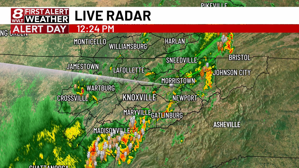
We have a few downpours and storms this morning, but we'll have to watch the afternoon as well. Another round of downpours and storms could cause slow downs for your commute. The latest on the WVLT First Alert Weather Day right now on WVLT News this morning! #wvltfirstalert

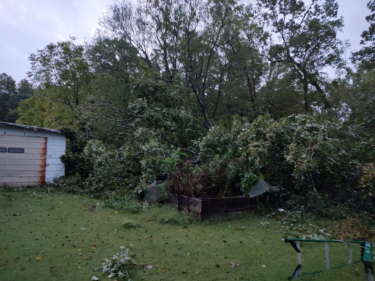
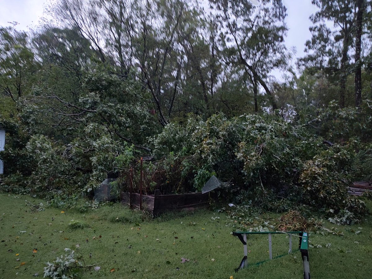
Our strong winds are beginning to bring down trees across the region. This is from Robyn Cardwell Kelly in Dandridge. Are you seeing any damage where you live? #wvltfirstalert
We're not done with the colder temperatures just yet! While Sunday will be another mild day, a chance for a frost and freeze arrives to start our week. We'll let you know how long the cold will last on WVLT News tonight at 11 p.m. #wvltfirstalert #tnwx #wvltwx
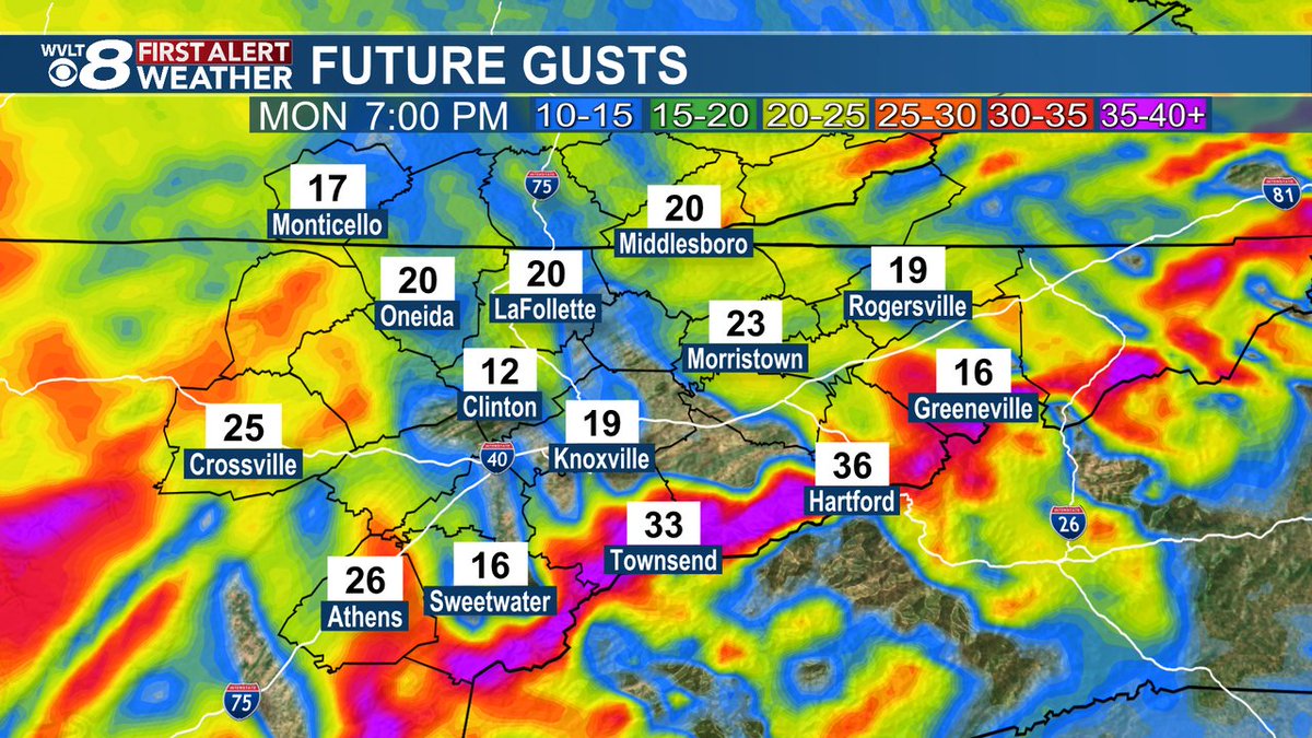
Monday will be another pleasant day to spend outdoors with warmer temperatures, but it will be breezy as winds gust close to 30 mph. Tune into WVLT News at 6:30 p.m. as we track the return of rain and storms and when winds could gust to 40 mph this week. #wvltfirstalert

Heads up! Our next batch of rain is pushing in from the south and will be sticking around into the evening commute creating ponding on the roadways. Allow yourself some extra time as you head home this evening. #wvltfirstalert

Right on track, additional showers and storms have developed along the plateau and are slowly drifting north and east. Here's a track of when they make it into the valley if they hold together. #wvltfirstalert

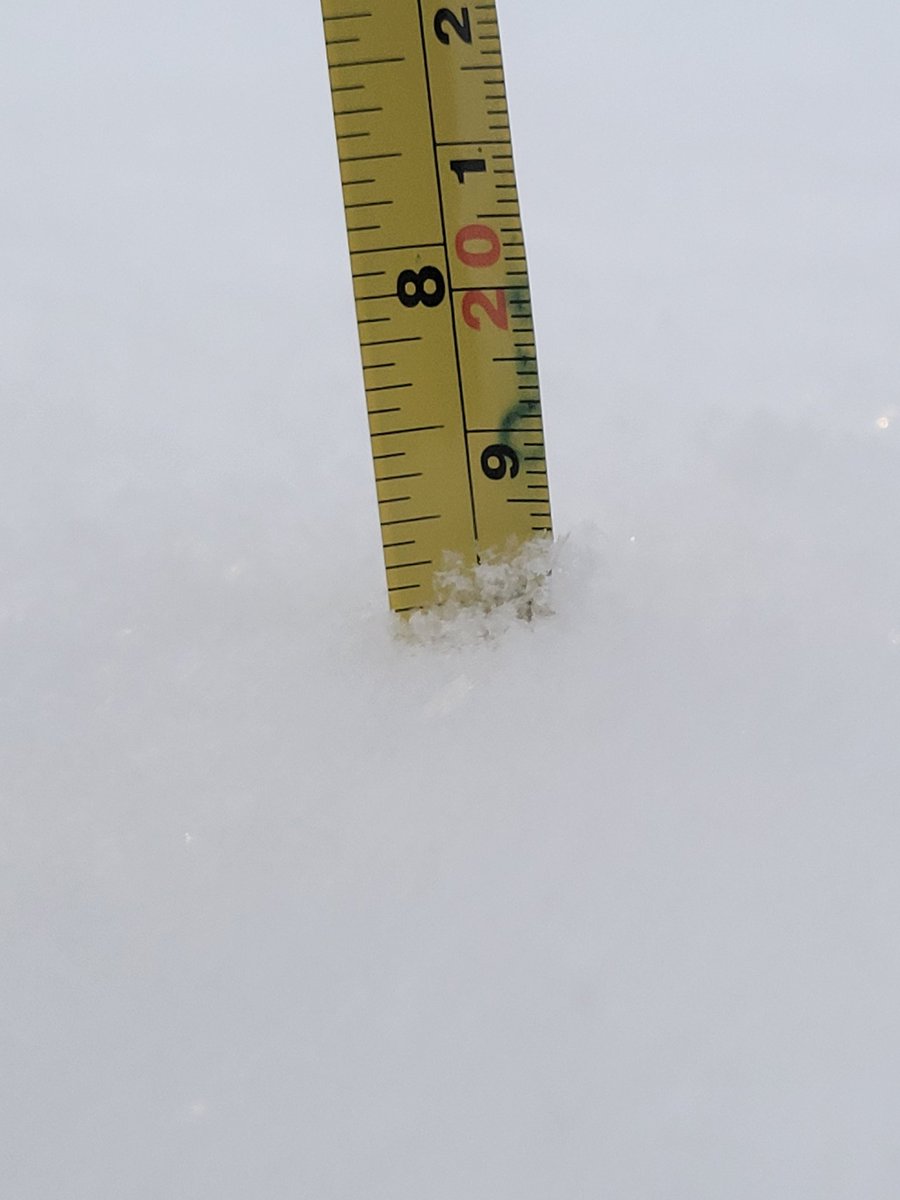
Snow is sticking to the trees at Newfound Gap! Temperatures have went from 40 down to 34 over the last two hours, Kuwohi is down to 29 degrees. #WVLTFirstAlert #snow #smokies

We're staying dry for Monday, but winds will pick up through the afternoon and evening. Expect gust close to 30 mph at times in the valley with higher gust in the higher elevations. We're tracking when rain returns tonight on WVLT News at 11. #wvltfirstalert #tnwx #wvltwx
We have issued a WVLT First Alert Weather Day for Wednesday evening with the potential for strong storms. The biggest risk is damaging winds with an isolated tornado risk. Tune into WVLT News starting at 3:30 p.m. as we break down the timing and impacts. #wvltfirstalert

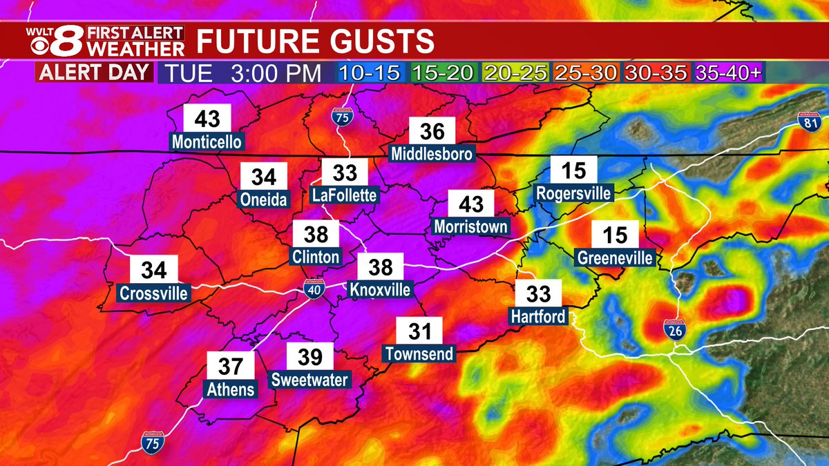
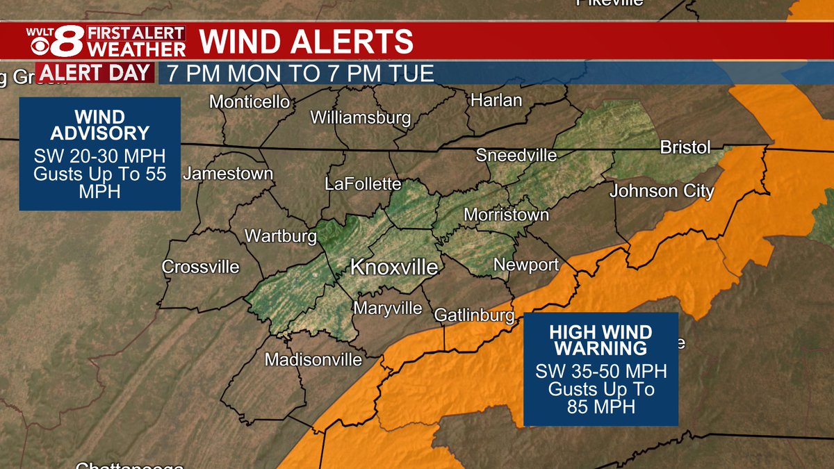
Heavy rain impacts our morning commute, but strong winds arrive for the afternoon and evening. Within the Wind Advisory gust could approach 55 mph, while the High Wind warning could see gust to 85 mph. We're timing out the latest on WVLT News from 4-6:30 p.m. #wvltfirstalert
The National Weather Service issued a Frost Advisory. Find details on the forecast where you live in the free WVLT First Alert Weather app or on wvlt.tv/weather. #WVLTFirstAlert #Frost
The National Weather Service issued a Frost Advisory. Find details on the forecast where you live in the free WVLT First Alert Weather app or on wvlt.tv/weather. #WVLTFirstAlert #Frost
The National Weather Service issued a Frost Advisory. Find details on the forecast where you live in the free WVLT First Alert Weather app or on wvlt.tv/weather. #WVLTFirstAlert #Frost
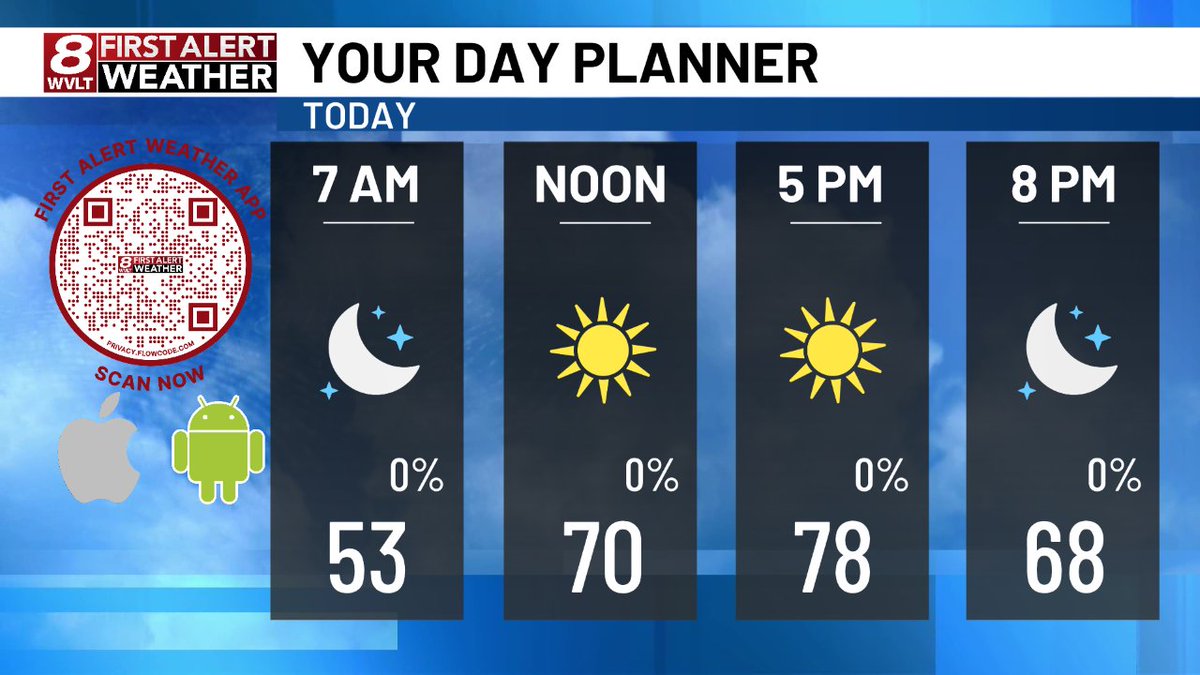
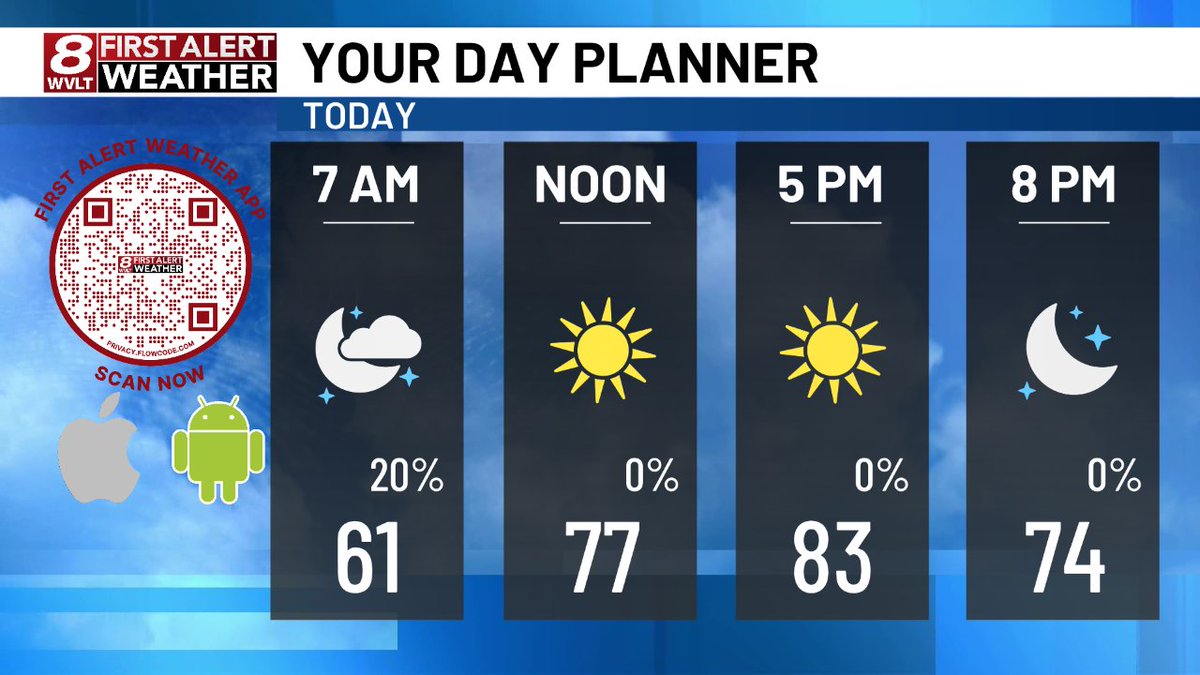
Here's a quick look at today's planner. Join us on @wvlt for your First Alert Forecast! wvlt.tv/weather #WVLTFirstAlert
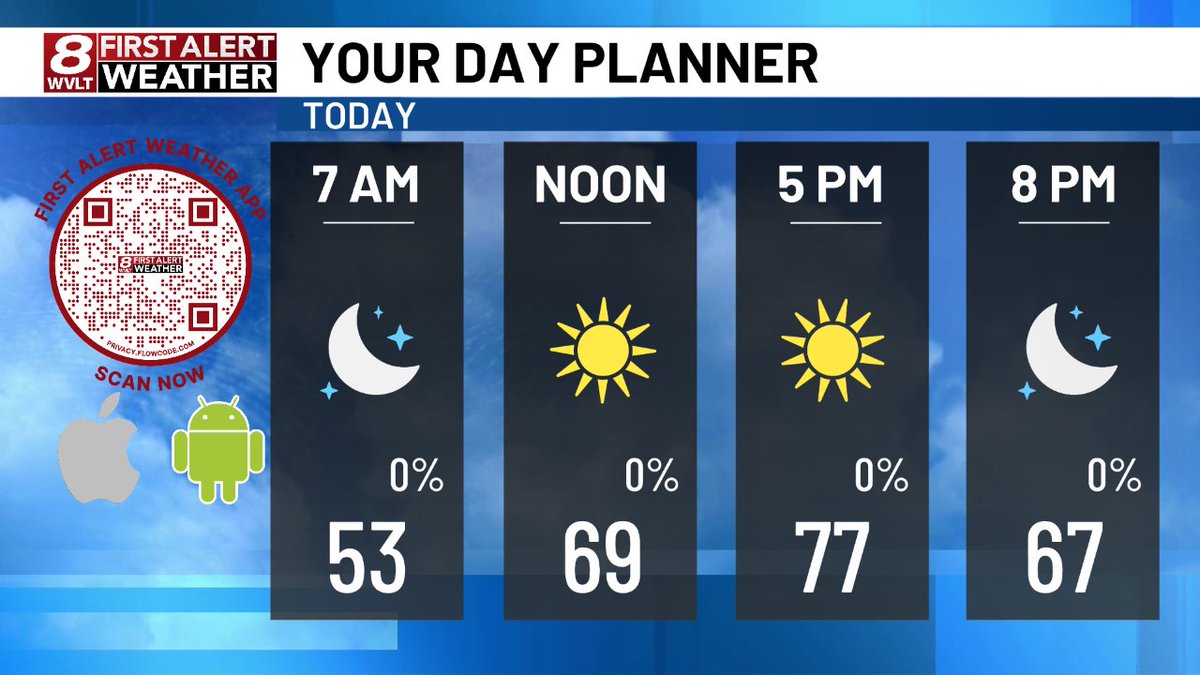
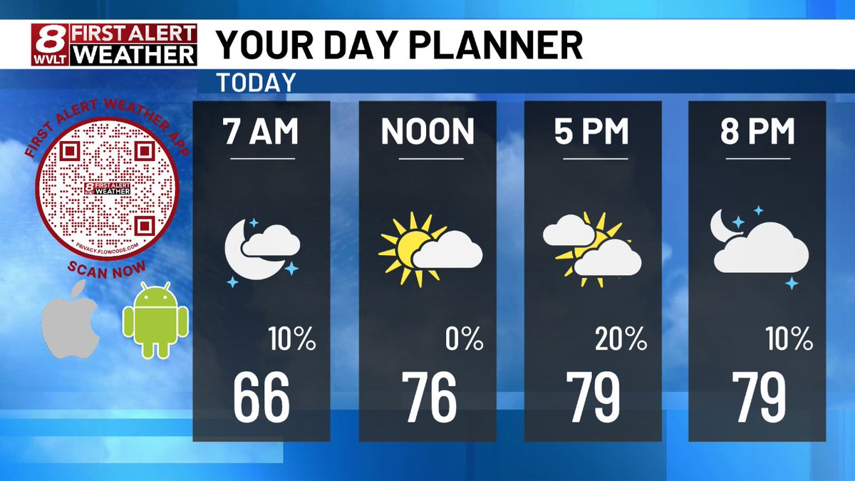
Here's a quick look at today's planner. Join us on @wvlt for your First Alert Forecast! wvlt.tv/weather #WVLTFirstAlert
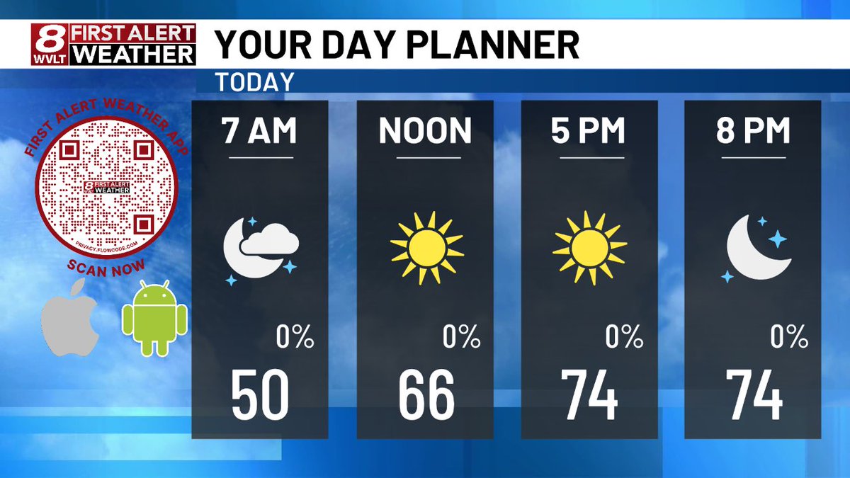
Here's a quick look at today's planner. Join us on @wvlt for your First Alert Forecast! wvlt.tv/weather #WVLTFirstAlert

Here's a quick look at today's planner. Join us on @wvlt for your First Alert Forecast! wvlt.tv/weather #WVLTFirstAlert
Here's a quick look at today's planner. Join us on @wvlt for your First Alert Forecast! wvlt.tv/weather #WVLTFirstAlert
Here's a quick look at today's planner. Join us on @wvlt for your First Alert Forecast! wvlt.tv/weather #WVLTFirstAlert

Here's a quick look at today's planner. Join us on @wvlt for your First Alert Forecast! wvlt.tv/weather #WVLTFirstAlert
Here's a quick look at today's planner. Join us on @wvlt for your First Alert Forecast! wvlt.tv/weather #WVLTFirstAlert

Here's a quick look at today's planner. Join us on @wvlt for your First Alert Forecast! wvlt.tv/weather #WVLTFirstAlert
Here's a quick look at today's planner. Join us on @wvlt for your First Alert Forecast! wvlt.tv/weather #WVLTFirstAlert
Here's a quick look at today's planner. Join us on @wvlt for your First Alert Forecast! wvlt.tv/weather #WVLTFirstAlert

Here's a quick look at today's planner. Join us on @wvlt for your First Alert Forecast! wvlt.tv/weather #WVLTFirstAlert
Here's a quick look at today's planner. Join us on @wvlt for your First Alert Forecast! wvlt.tv/weather #WVLTFirstAlert
Here's a quick look at today's planner. Join us on @wvlt for your First Alert Forecast! wvlt.tv/weather #WVLTFirstAlert

Here's a quick look at today's planner. Join us on @wvlt for your First Alert Forecast! wvlt.tv/weather #WVLTFirstAlert
Here's a quick look at today's planner. Join us on @wvlt for your First Alert Forecast! wvlt.tv/weather #WVLTFirstAlert
Here's a quick look at today's planner. Join us on @wvlt for your First Alert Forecast! wvlt.tv/weather #WVLTFirstAlert
Ummm excuse me @wvlt you scared (excited? 🤔) my hubby this morning with this alert. 🤭🤭. #wvltfirstalert #head #heatalert
Heads up! Our next batch of rain is pushing in from the south and will be sticking around into the evening commute creating ponding on the roadways. Allow yourself some extra time as you head home this evening. #wvltfirstalert
We have a few downpours and storms this morning, but we'll have to watch the afternoon as well. Another round of downpours and storms could cause slow downs for your commute. The latest on the WVLT First Alert Weather Day right now on WVLT News this morning! #wvltfirstalert
Much needed rainfall is on the way over the next 24 hours, but a good reminder to drive with caution on the roadways, especially with wet leaves. Here's a look at the stopping distances if you're traveling at 40 mph. #WVLTFirstAlert #tnwx #wvltwx
Heavy rain impacts our morning commute, but strong winds arrive for the afternoon and evening. Within the Wind Advisory gust could approach 55 mph, while the High Wind warning could see gust to 85 mph. We're timing out the latest on WVLT News from 4-6:30 p.m. #wvltfirstalert
Monday will be another pleasant day to spend outdoors with warmer temperatures, but it will be breezy as winds gust close to 30 mph. Tune into WVLT News at 6:30 p.m. as we track the return of rain and storms and when winds could gust to 40 mph this week. #wvltfirstalert
Our strong winds are beginning to bring down trees across the region. This is from Robyn Cardwell Kelly in Dandridge. Are you seeing any damage where you live? #wvltfirstalert
Are we looking at a mirror or the Tennessee River? Check out the cool view from Erin Bradford from the Gay Street Bridge. A perfect mirror image of the clouds on a slick calm day. #tnwx #wvltwx #WVLTFirstAlert
Right on track, additional showers and storms have developed along the plateau and are slowly drifting north and east. Here's a track of when they make it into the valley if they hold together. #wvltfirstalert
Here's a quick look at today's planner. Join us on @wvlt for your First Alert Forecast! wvlt.tv/weather #WVLTFirstAlert
We're not done with the colder temperatures just yet! While Sunday will be another mild day, a chance for a frost and freeze arrives to start our week. We'll let you know how long the cold will last on WVLT News tonight at 11 p.m. #wvltfirstalert #tnwx #wvltwx
Good Saturday morning! We're tracking areas of dense fog to start the day. Take it slow as you head out the door with many areas under a mile visibility at times. We're tracking additional rain chances on WVLT News this morning at 7 a.m. #wvltfirstalert #tnwx #wvltwx
Get ready for big changes! Colder temperatures settle in for our Monday and we'll feel even colder with breezy conditions. Tune into WVLT News tonight at 11 p.m. as we break down our week ahead. #wvltfirstalert #tnwx #wvltwx
ANOTHER ARCTIC SURGE EARLY NEXT WEEK! More arctic air returns Monday through Wednesday behind this weekend’s cold front! (Jan 20-22nd) HOW COLD? Teens and 20s with single digit wind chills. #WVLTFirstAlert #Brrr
We have issued a WVLT First Alert Weather Day for Wednesday evening with the potential for strong storms. The biggest risk is damaging winds with an isolated tornado risk. Tune into WVLT News starting at 3:30 p.m. as we break down the timing and impacts. #wvltfirstalert
Snow is sticking to the trees at Newfound Gap! Temperatures have went from 40 down to 34 over the last two hours, Kuwohi is down to 29 degrees. #WVLTFirstAlert #snow #smokies
We're staying dry for Monday, but winds will pick up through the afternoon and evening. Expect gust close to 30 mph at times in the valley with higher gust in the higher elevations. We're tracking when rain returns tonight on WVLT News at 11. #wvltfirstalert #tnwx #wvltwx
Something went wrong.
Something went wrong.
United States Trends
- 1. Mueller N/A
- 2. #OGCHIBI N/A
- 3. #UFCLondon N/A
- 4. chappell N/A
- 5. Charlie Kirk N/A
- 6. Jazzy N/A
- 7. Coen Carr N/A
- 8. Brit N/A
- 9. Louisville N/A
- 10. Dimona N/A
- 11. Mason Jones N/A
- 12. Michigan State N/A
- 13. Arad N/A
- 14. Clemson N/A
- 15. Danny Silva N/A
- 16. Patterson N/A
- 17. Jeremy Fears N/A
- 18. Austen Lane N/A
- 19. Izzo N/A
- 20. Gronk N/A