#wildcatfire ผลการค้นหา

#WildcatFire in Barona [final] Fire is fully contained at one acre. Firefighters are wrapping up and will come available shortly. Wildcat Canyon Rd is reopened for traffic.
![CALFIRESANDIEGO's tweet image. #WildcatFire in Barona [final] Fire is fully contained at one acre. Firefighters are wrapping up and will come available shortly. Wildcat Canyon Rd is reopened for traffic.](https://pbs.twimg.com/media/FysKRUpX0BUcan8.jpg)

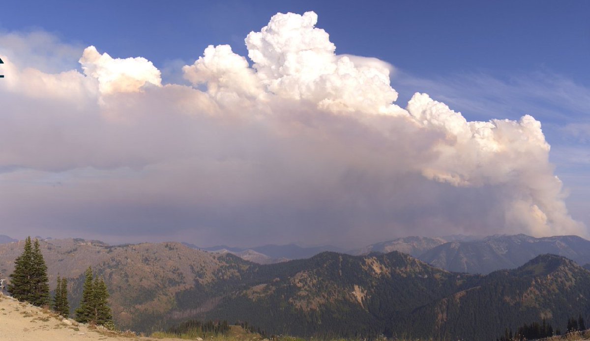
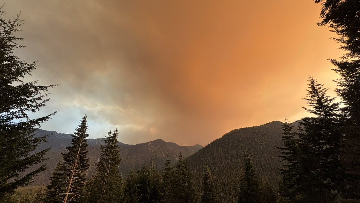
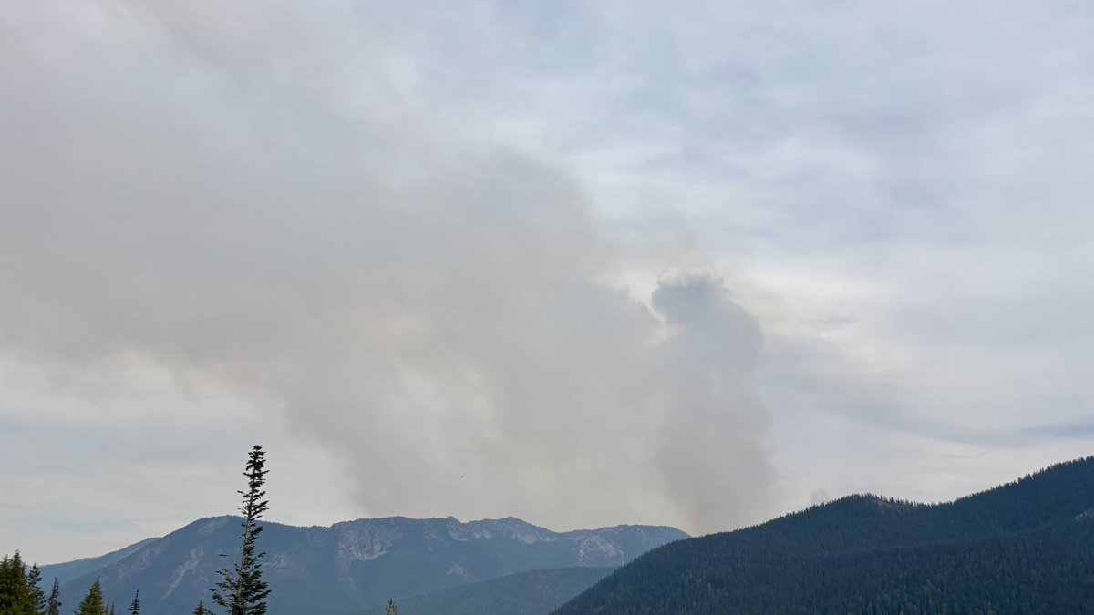
The #WildcatFire east of Mount Rainier is producing a pyrocumulonimbus cloud ("pyro" = fire) producing LIGHTNING! This happens occasionally with very vigorous fires and strong upward motion. It creates it's own "thunderstorm"! #wawx
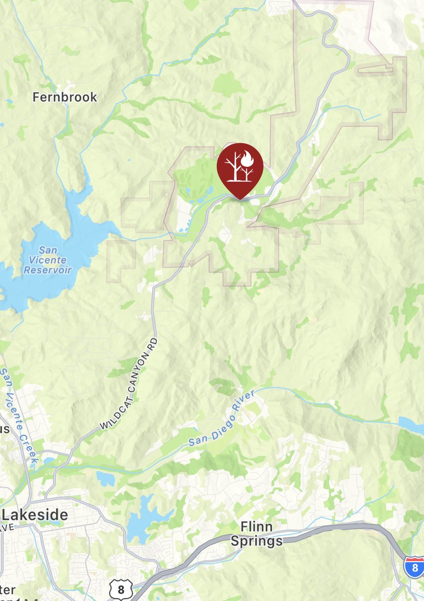
#WildcatFire [Update] The fire is 10 to 15 acres in medium fuels with a potential for 100 acres. This fire is threatening Barona Mesa Road and Calistoga Place. Additional crews, and aircraft have been ordered. alertca.live/cam-console/21…
![CALFIRESANDIEGO's tweet image. #WildcatFire [Update] The fire is 10 to 15 acres in medium fuels with a potential for 100 acres. This fire is threatening Barona Mesa Road and Calistoga Place. Additional crews, and aircraft have been ordered.
alertca.live/cam-console/21…](https://pbs.twimg.com/media/FzGmA0lakAAiMdm.jpg)

UPDATE: The evacuation warnings for the #WildcatFire in Barona have been lifted. trib.al/BajKBmX
fox5sandiego.com
Barona brush fire stopped at 12 acres; evacuation warnings lifted
A brush fire in the Barona area of East County burned 20 acres Tuesday and led to an evacuation warning for some residents.


#WildcatFire in Barona [final] Fire is now 100% contained at 12.2 acres; all resources available. SD County utilizes the ‘SD Emergency’ app to relay critical info during an emergency. Download it on your smartphone and visit AlertSD.org for more info.
WATCH: The #WildcatFire east of Mount Rainier putting out massive amounts of smoke this afternoon, with a timelapse from Crystal Mountain showing the plume. More on @KIRO7Seattle now at 5. kiro7.com/video/ #wawx #wafire
.@CALFIRESANDIEGO is at scene with Barona FD of a vegetation fire along Wildcat Canyon Rd east of Quincy Canyon Rd in Barona. Fire spread stopped at one acre; firefighters will remain at scene for mop up and containment. #WildcatFire

#WildcatFire #AZFire #AZTNF bit.ly/3QW3cgh Wildcat Fire: Updated Publication Added: Wildcat Fire

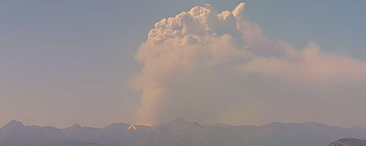
The #WildcatFire to the east of Mt. Rainier is exploding today due to unstable and windy conditions. It is over 1,000 acres in size and quickly growing. The image below is from the Crystal Mountain webcam 10 minutes ago. #wawx
#WildcatFire [Update] Forward rate of progress stopped at 20 acres. Evacuation Warnings remain in place.
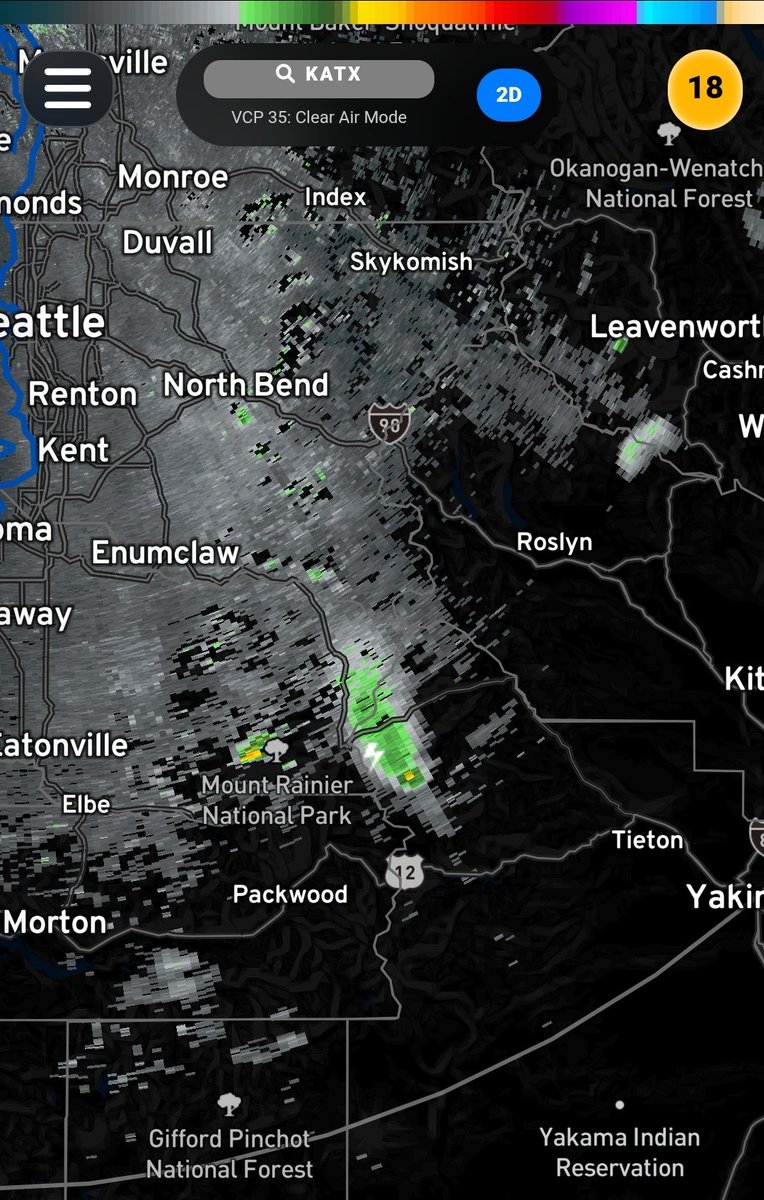
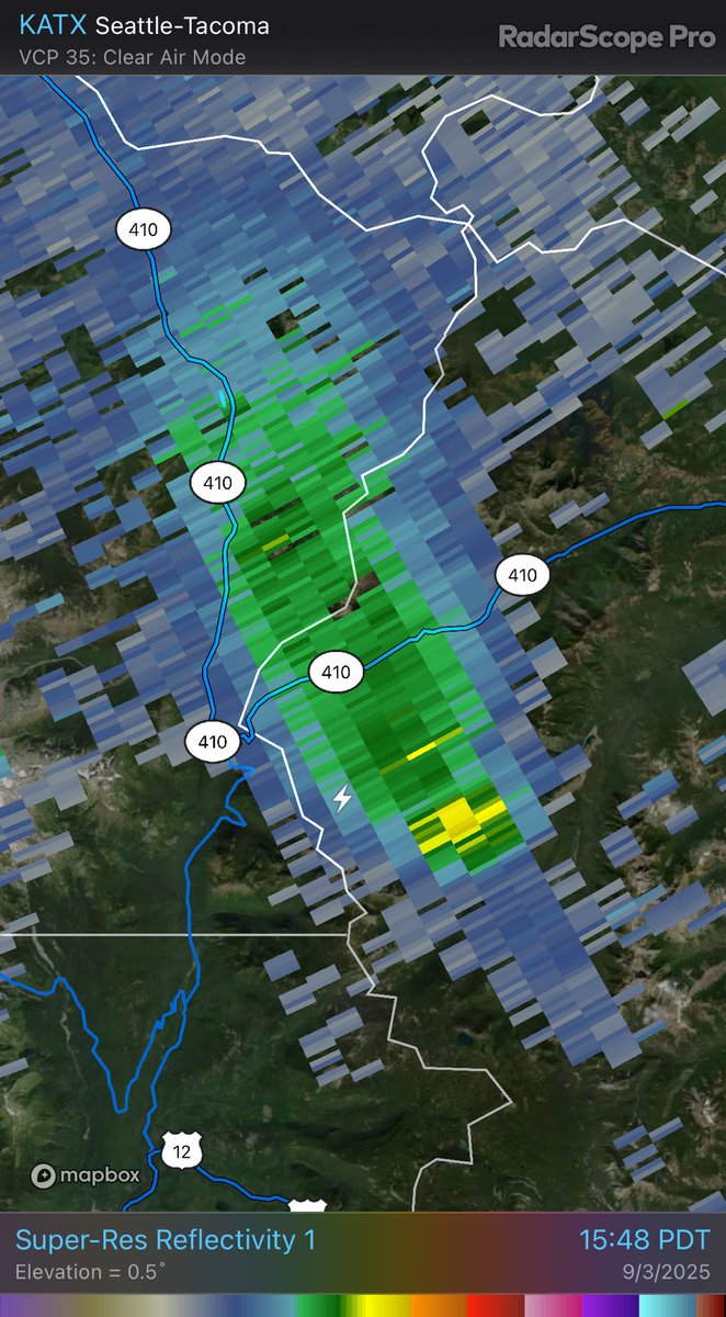
We’ve got shower and thunderstorm activity moving NW this morning off the Cascades. How far it lasts is questionable, but decaying storms are producing some rain over Thurston County (high-based storms), and there has been lightning over the Cascades near the #WildcatFire. #wawx

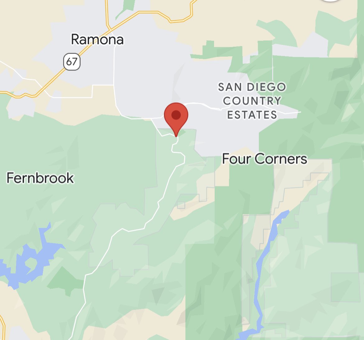
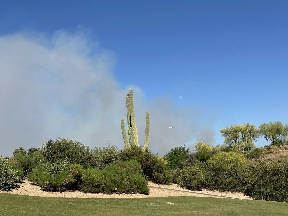
.@CALFIRESANDIEGO is at the scene of a vegetation fire on 1800 block of Barona Road in the community of Barona. Five acres running uphill with a potential of 30 acres. This is in the area of the paintball park. #WildcatFire

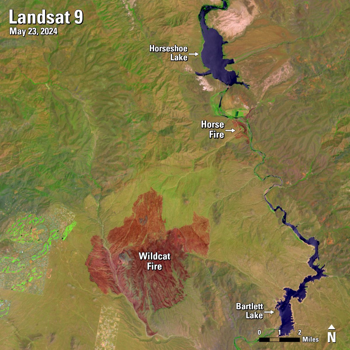
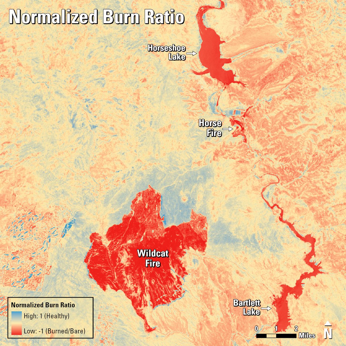
Arizona’s #WildcatFire, which started on May 18, has scorched 14,402 acres in the #TontoNationalForest. #Landsat #NormalizedBurnRatio and Level-3 #BurnedArea #ScienceProducts show the extent of the fire. Learn more here: ow.ly/v6Ac50S15Yb #WildfireAwarenessMonth


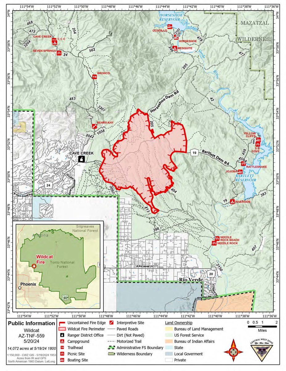
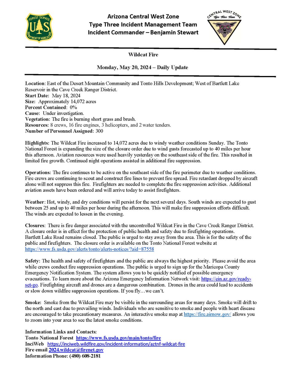
#WildcatFire Update- Monday, May 20, 2024 Location: East of the Desert Mountain Community and Tonto Hills Development; West of Bartlett Lake Reservoir in the Cave Creek Ranger District. Start Date: May 18, 2024 Size: Approx. 14,072 acres Percent Contained: 0% Read more below⬇️

New 🔥 Start: #WildcatFire - Fishlake NF (Beaver Co.) Est 10 acres. Smoke may be visible from I-70/I-15. Firefighters are working in challenging, inaccessible terrain, with local engine & Initial Attack resources on scene. Cause is under investigation. Do not report. #ffslkmg

Incredible pyrocumulonimbus going on right now 😮 Creating its own lightning ⚡️ #Wildcatfire #wawx #pnw


#WildcatFire #WAOWF inciweb.wildfire.gov/incident-publi… Wildcat Fire: Updated Publication Added: Wildcat Fire

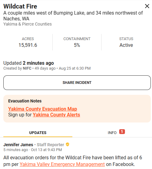
#WildcatFire This fire has been marked as fully contained and should stay confined to its boundaries, FINAL UPDATE
#WildcatFire Some great news from crews working on the Wildcat Fire! Containment has been increased from 40% to 90%, this fire is nearing its full end with even more rain and snow in the forecast! Fire season is over!! 🎉

In just now from Watch Duty from the #WildcatFire burning near Crystal Mountain, near 410. Great news, all evacuation orders have been lifted which was the Level 2 evacuation remaining. #wawx

NEW FIRE START: #WildcatFire - Beaver County, estimated 10 acres. Smoke may be visible from I-70/I-15. Firefighters are working in challenging, inaccessible terrain, with local engine & Initial Attack resources on scene. Cause is under investigation. Do not report. #ffslkmg

🔥 Here’s the #WildcatFire burning in Beaver County, southeast of Cove Fort with smoke 💨 likely visible from I-15 & I-70. 🌧️ Rain is expected in the area. The fire was reported earlier Thursday morning in inaccessible terrain resulting in a long hike for ground crews. Last
New 🔥 Start: #WildcatFire - Fishlake NF (Beaver Co.) Est 10 acres. Smoke may be visible from I-70/I-15. Firefighters are working in challenging, inaccessible terrain, with local engine & Initial Attack resources on scene. Cause is under investigation. Do not report. #ffslkmg

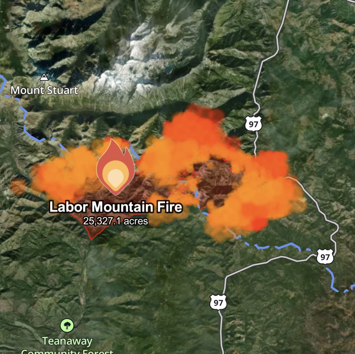
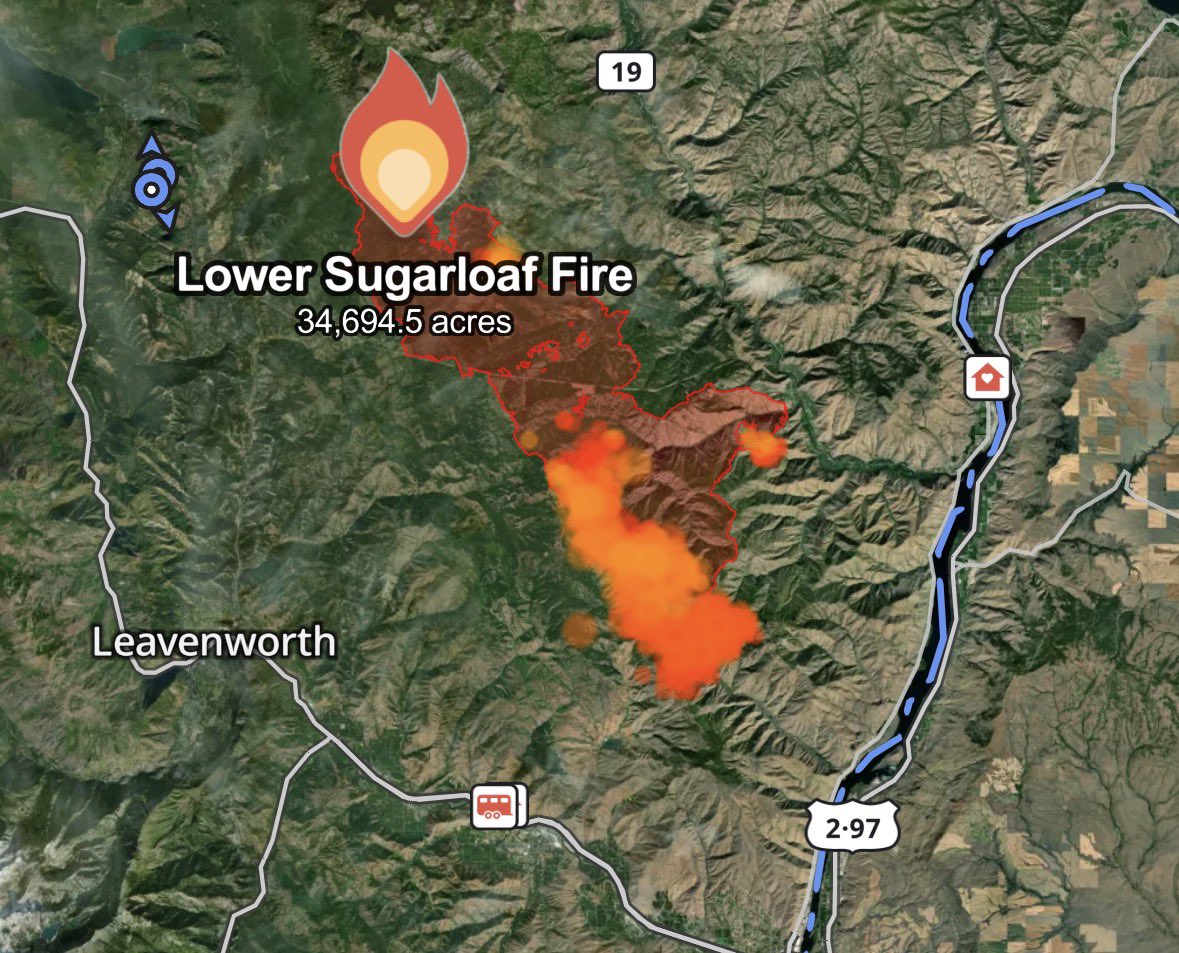
This View of major wildfires across Washington State was captured live from @sen's 4K external camera payload on the @Space_Station at 3:22 pm PDT this afternoon. #WildcatFire #LowerSugarloafFire #LaborMountainFire @PortlandGov @CityofSeattle @SpokaneCity @NWSSeattle
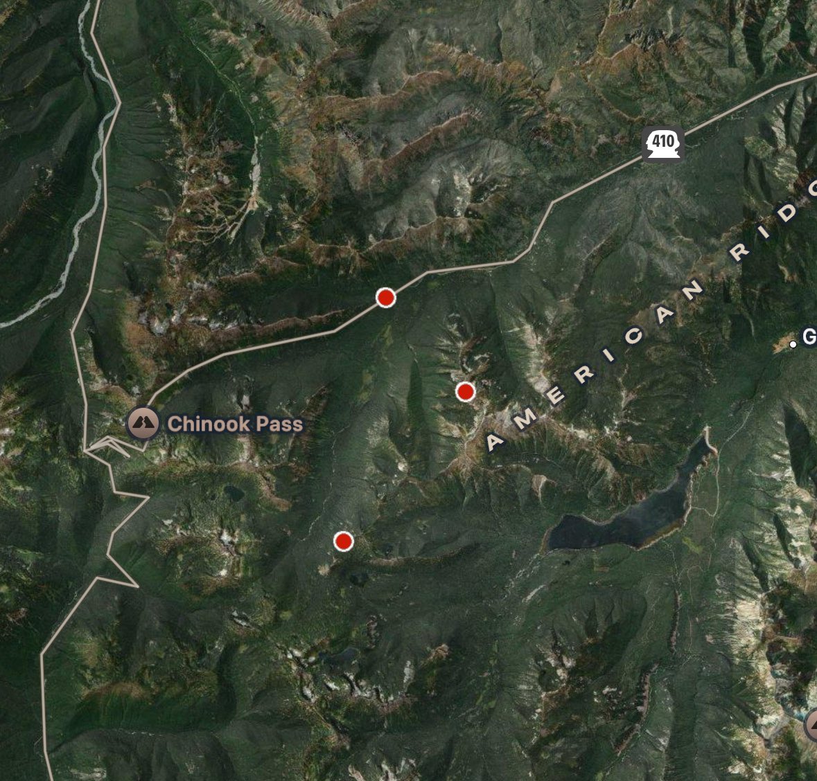
Thursday was a bad day for fires in the Cascades. The #LaborMountainFire crossed US-97 and grew nearly 8K acres. The #LowerSugarloafFire grew 4K acres to the SE, with new level 3 evacuations. The #WildcatFire grew too, getting very close to Goose Prairie. #wawx
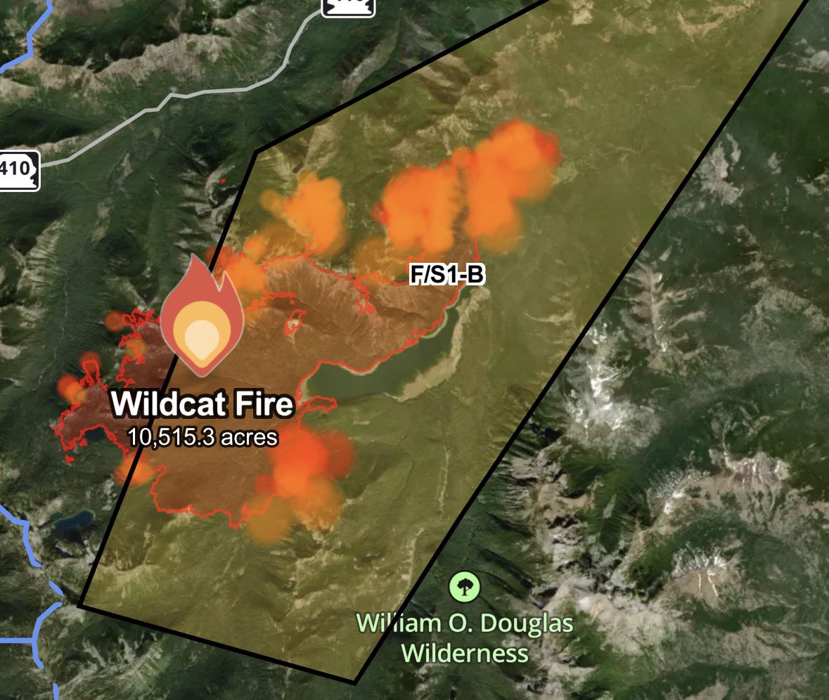

We need support on the #wafire #wildcatfire. There are historic and lived in homes directly in the path, and with one way in/out it's too dangerous for firefighters. We need #airsupport quickly for #bumpinglake and #gooseprairie.
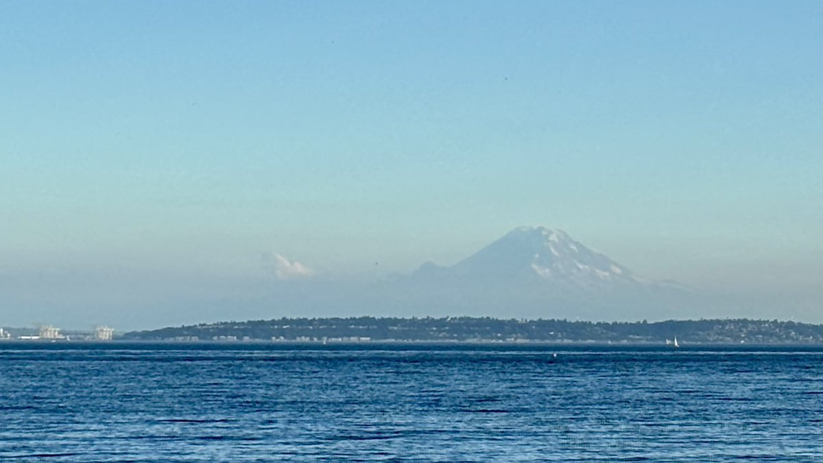
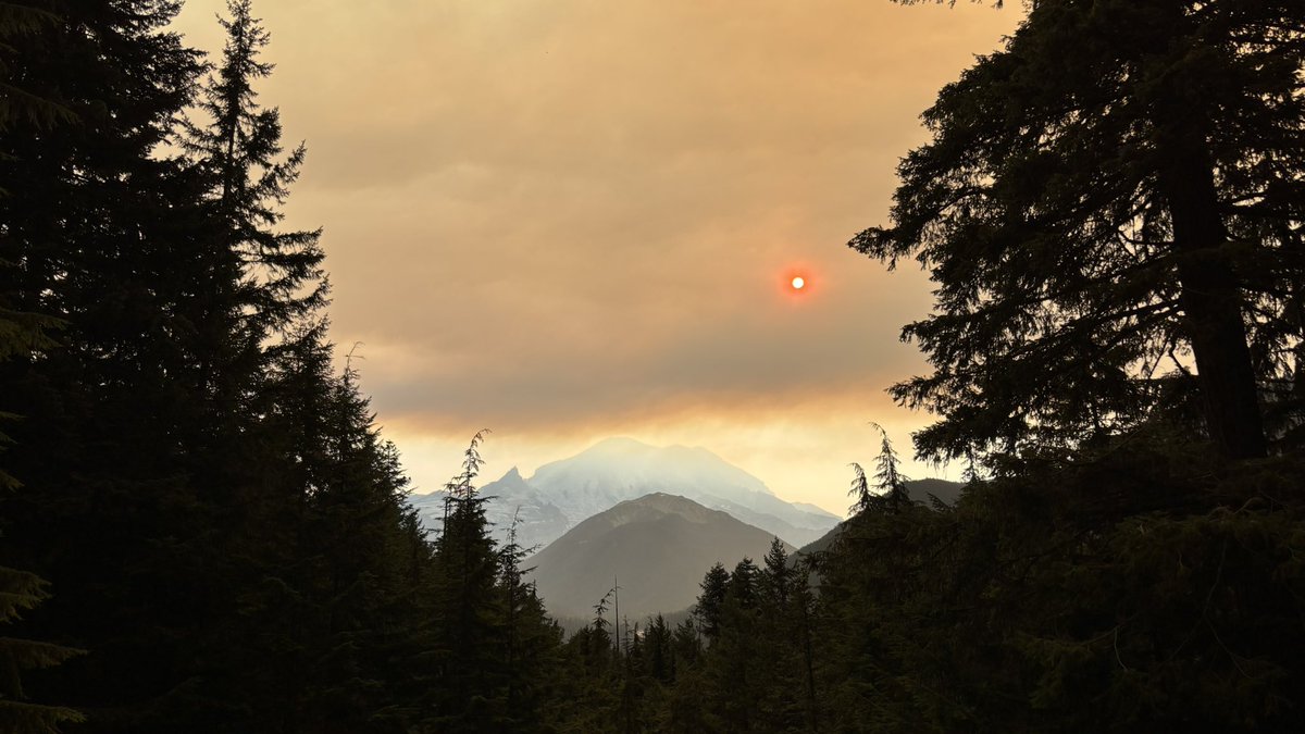
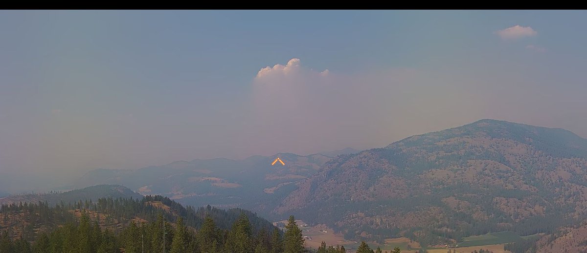
Blurry phone photo of the #WildcatFire pyrocumulus cloud and a barren Mt. Rainier as seen from northern Bainbridge Island around 6:10 PM Saturday. #wawx
Drone shot on the evening of Tuesday, Sept. 2nd, as the smoke plume from the #WildcatFire blew north over Cle Elum. The fire would go on to grow over 3,000 acres in the ensuing 24 hours. #wawx

Nice storm over the #WildcatFire right now, hopefully bringing some much needed rain without too much lightning! #wawx


. @NWSEastern IMET trainee en route to #WildcatFire near Naches, WA #WAwx #WAFires @NWSPendleton @OkaWenNF inciweb.wildfire.gov/incident-infor… Map courtesy Inciweb

. @NWSMedford IMET en route to #WildcatFire near Naches, WA #WAwx #WAFires @NWSPendleton @OkaWenNF inciweb.wildfire.gov/incident-infor… Photo courtesy Inciweb

Arizona’s #WildcatFire, which started on May 18, has scorched 14,402 acres in the #TontoNationalForest. #Landsat #NormalizedBurnRatio and Level-3 #BurnedArea #ScienceProducts show the extent of the fire. Learn more here: ow.ly/v6Ac50S15Yb #WildfireAwarenessMonth
Blurry phone photo of the #WildcatFire pyrocumulus cloud and a barren Mt. Rainier as seen from northern Bainbridge Island around 6:10 PM Saturday. #wawx


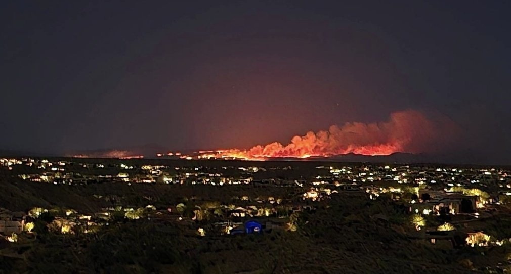
Lots of tankers over my area yesterday and today as hot shot crews tackle the #wildcatfire Hope for no evacuations, last check was 5,000 acres burned.

Not a CAL FIRE incident/ assisting: #WildcatFire near Forest Service Road 10S069 and Trimmer Springs Road, Pine Flat in Fresno County. Lead agency: @Sierra_NF fire.ca.gov/incidents/2023…
We’ve got shower and thunderstorm activity moving NW this morning off the Cascades. How far it lasts is questionable, but decaying storms are producing some rain over Thurston County (high-based storms), and there has been lightning over the Cascades near the #WildcatFire. #wawx

#WildcatFire [Update] The fire is 10 to 15 acres in medium fuels with a potential for 100 acres. This fire is threatening Barona Mesa Road and Calistoga Place. Additional crews, and aircraft have been ordered. alertca.live/cam-console/21…

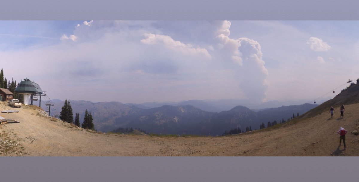
A view of the #WildcatFire producing a pyrocumulus cloud this afternoon, on the 1:40 PM Crystal Mountain summit camera shot. The fire is producing clouds estimated by radar to be 26,000 feet high. #wawx

Incredible pyrocumulonimbus going on right now 😮 Creating its own lightning ⚡️ #Wildcatfire #wawx #pnw


#WildcatFire, #BearGulchFire, #LowerSugarloafFire, and #CrownCreekFire/#BlackhawkMountainFire all burning actively this afternoon. Read the latest WA Smoke Blog for more info ➡️ wasmoke.blogspot.com #wawx #wawildfire
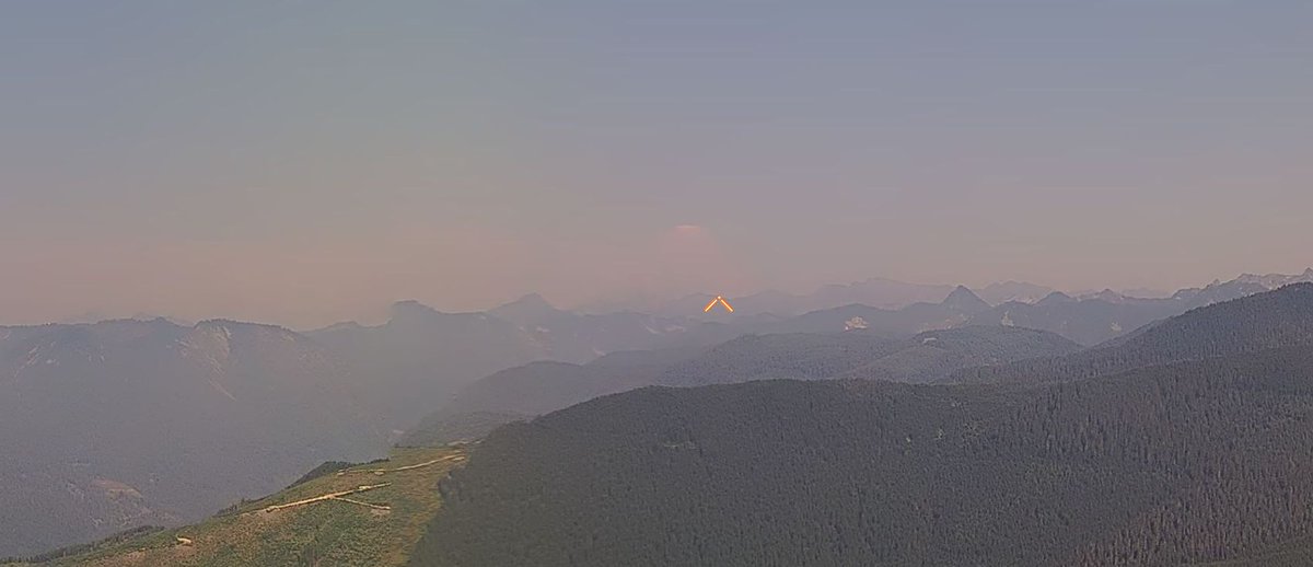
The #WildcatFire is burning so hot that it just generated its own thunderstorm, also known as a pyrocumulonimbus! This will likely cause the fire to spread even more via lightning strikes caused by it. Basically creating a wildfire feedback loop...🌩🔥 #wawx
WOW…we’ve got lightning in the #WildcatFire now. This is a pyrocumulonimbus cloud, and the fire is rapidly growing. Extraordinary. #wawx
Something went wrong.
Something went wrong.
United States Trends
- 1. Mike Evans N/A
- 2. Falcons N/A
- 3. DONALD GLOVER N/A
- 4. Titans N/A
- 5. 49ers N/A
- 6. Giants N/A
- 7. Bowles N/A
- 8. Luke Kornet N/A
- 9. Chiefs N/A
- 10. Bucs N/A
- 11. Bengals N/A
- 12. Raiders N/A
- 13. Cardinals N/A
- 14. Saints N/A
- 15. Oweh N/A
- 16. Devin Lloyd N/A
- 17. Mafe N/A
- 18. Penix N/A
- 19. Willis N/A
- 20. Broncos N/A