#komuwx 検索結果

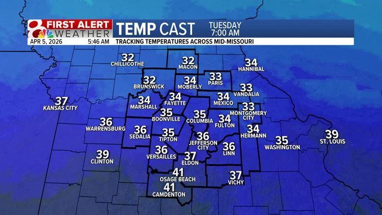
REST OF YOUR WEEKEND: Temperatures today and Sunday will reach the 70s for highs, with clouds overall increasing. Storm chances don't ramp up until Sunday night into Monday. I'll have the details streaming on @KOMUNews at 6! #mowx #midmowx #komuwx
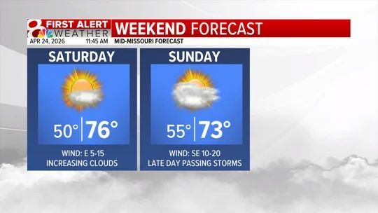
SUNDAY: While all eyes are on Monday for the potential of strong storms, Sunday looks to bring a nice end to the weekend. Highs in the 70s with a few clouds make it good for outdoor activities. #mowx #midmowx #komuwx

COLD FRONT: A cold front crashed through last night, bringing storms and sweeping out moisture. Dew points in the 20s and 30s overspread Mid-Missouri. This will keep storm activity at bay as we start the next week. #mowx #midmowx #komuwx

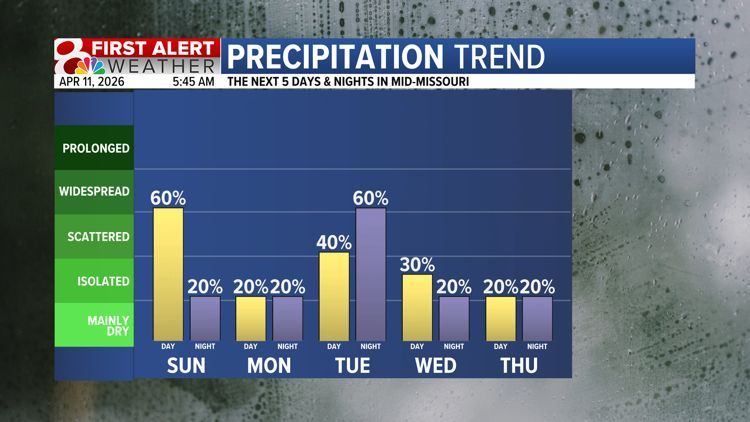
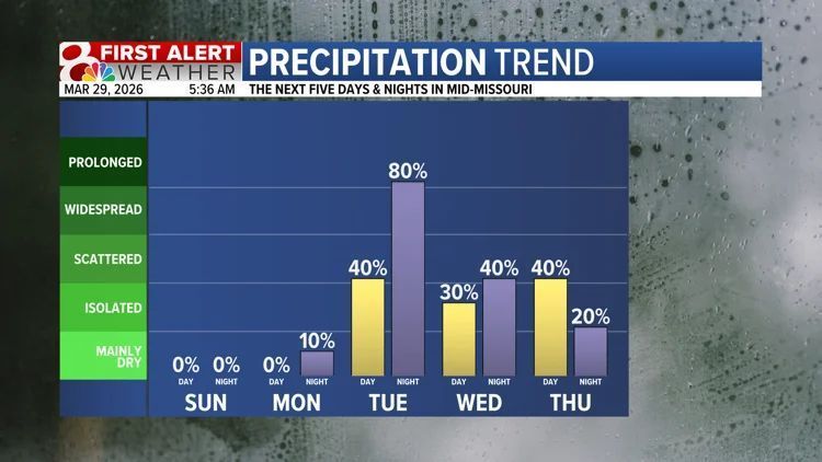
ACTIVE PATTERN AHEAD: Showers and storms will be likely Tuesday through Friday, with substantial rainfall and stronger storms being possible. We don't expect this to be anything out of the ordinary for spring, but the rain/storms could be inconvenient. #mowx #midmowx #komuwx

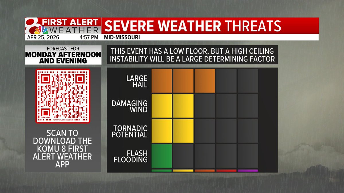
MONDAY SEVERE POTENTIAL: We are growing more confident in an environment capable of strong storms on Monday, but a couple questions remain. How unstable will the atmosphere be, and where will storms manage to form? I'll have the latest on @KOMUNews at 6. #mowx #midmowx #komuwx
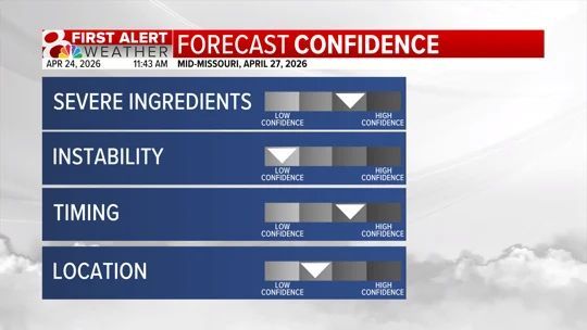
Monday is a First Alert Weather Day due to severe potential in the afternoon and evening. Still some questions around just how strong these storms will be. I'll take you through it on @KOMUNews at 6. #mowx #midmowx #komuwx

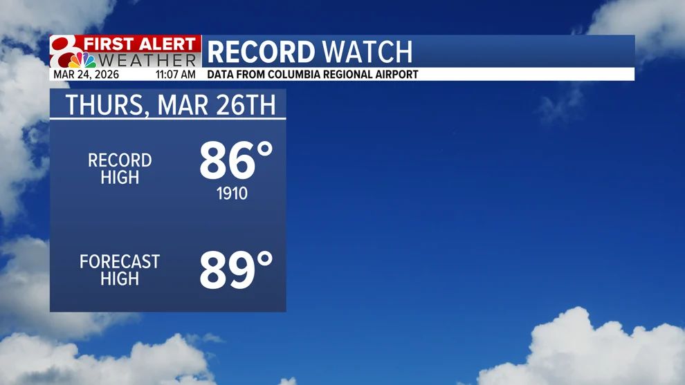
More record warmth? That's what we are forecasting this Thursday, with us once again nearing the 90s. If you have outdoor activities, let's make sure we're staying hydrated and taking time to cool off when needed. #mowx #midmowx #komuwx

ACTIVE PATTERN AHEAD: Rain chances will be up and down through the week, with our best chances on Tuesday. A stronger storm or two can't be ruled out on Tuesday or Wednesday, but there are still many questions about just how strong those storms will be. #mowx #midmowx #komuwx
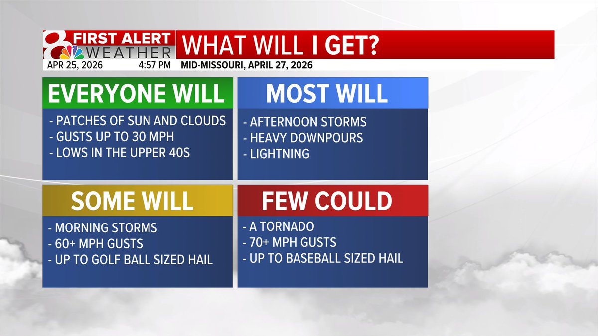
FIRST ALERT WEATHER DAY: Monday has the potential of strong storms. The main question is if morning storms will zap instability. If this does happen, the severe threat is lower. I'll tell you what happens if it doesn't on @KOMUNews at 9 and 10. #mowx #midmowx #komuwx

Wildfire smoke is beginning to move out today, and is replaced by cloud cover. We'll also begin a warming trend tomorrow that ramps up both the heat and humidity by the end of the week. komu.com/weather/foreca… #mowx #midmowx #komuwx
komu.com
Forecast: Smoke clears out and clouds build in
Temperatures today will stay pleasant, smoke moves out while increasing clouds build this evening.
TUESDAY STORMS: Our partners at the Storm Prediction Center do not currently have us in a severe weather risk for Tuesday. While a 1/5 risk for damaging wind gusts could be introduced, we don't expect any major problems. #mowx #midmowx #komuwx


THE WEEKEND AHEAD: On and off rain chances are expected this weekend, but there will still be dry time throughout both Saturday and Sunday. A few rumbles of thunder are possible, but no severe weather is expected. #mowx #midmowx #komuwx

RAINY WEEK AHEAD: Tuesday will be the start of a wet period. Heavy rain and storms are expected Tuesday night, before we see lighter on and off showers for the remainder of the week. I'll tell you how much rain we expect on @KOMUNews at 5, 9, and 10! #mowx #midmowx #komuwx
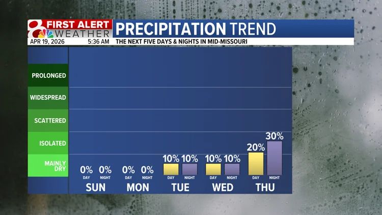
SUNSHINE AHEAD: After an active pattern, the weather in Mid-Missouri is expected to settle down for once. This won't last long though, as a more active pattern returns sooner rather than later. I'll tell you when on @KOMUNews at 9 and 10! #mowx #midmowx #komuwx

THE FIRST ALERT: A First Alert Weather Day is in place for this afternoon and this evening. Large hail, damaging wind gusts, and a spin-up tornado or two are all possible today. I'll have the latest on @KOMUNews at noon. #mowx #midmowx #komuwx


ABUNDANT RAIN: We expect that it will rain often Tuesday - Friday. The bad news is that dreary, inconvenient weather is likely. The good news is that this will likely get rid of any remaining drought concerns in Mid-Missouri. #mowx #midmowx #komuwx

DRY TIME: After how active late last week was, this dry time is a welcome change. It won't last long, though, as thunderstorm chances return late next week. #mowx #midmowx #komuwx
NICE MONDAY: Temperatures starting in the 50s and warming to the 80s make it feel more like May than March. This will be the warmest day we see for a while. #mowx #midmowx #komuwx

ROLLER COASTER CONTINUES: Highs will warm to the lower to middle 80s to begin the work week, before a cold front passes through, bringing storm chances, and highs down to the 50s. #mowx #midmowx #komuwx

FIRST ALERT WEATHER DAY: Monday has the potential of strong storms. The main question is if morning storms will zap instability. If this does happen, the severe threat is lower. I'll tell you what happens if it doesn't on @KOMUNews at 9 and 10. #mowx #midmowx #komuwx
SUNDAY: While all eyes are on Monday for the potential of strong storms, Sunday looks to bring a nice end to the weekend. Highs in the 70s with a few clouds make it good for outdoor activities. #mowx #midmowx #komuwx
MONDAY SEVERE POTENTIAL: We are growing more confident in an environment capable of strong storms on Monday, but a couple questions remain. How unstable will the atmosphere be, and where will storms manage to form? I'll have the latest on @KOMUNews at 6. #mowx #midmowx #komuwx
Monday is a First Alert Weather Day due to severe potential in the afternoon and evening. Still some questions around just how strong these storms will be. I'll take you through it on @KOMUNews at 6. #mowx #midmowx #komuwx
REST OF YOUR WEEKEND: Temperatures today and Sunday will reach the 70s for highs, with clouds overall increasing. Storm chances don't ramp up until Sunday night into Monday. I'll have the details streaming on @KOMUNews at 6! #mowx #midmowx #komuwx
DRY TIME: After how active late last week was, this dry time is a welcome change. It won't last long, though, as thunderstorm chances return late next week. #mowx #midmowx #komuwx
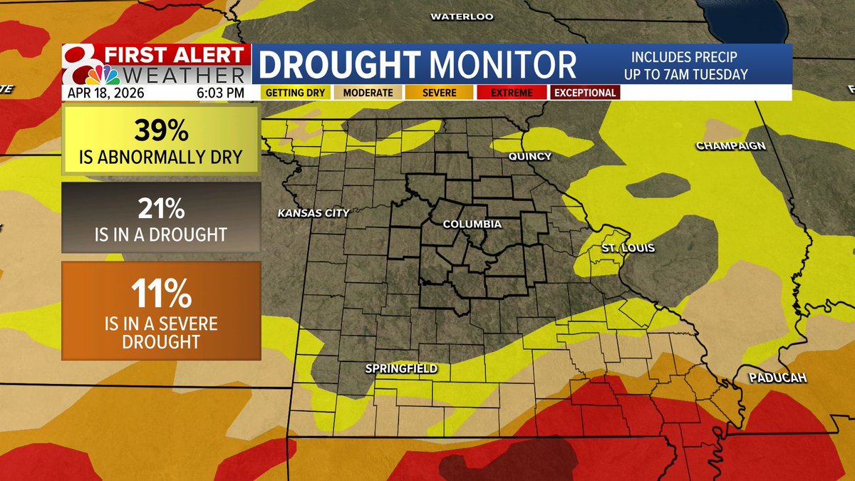
DROUGHT UPDATE: Strong storms are never good news, but at least they help relieve drought. Mid-Missouri isn't in drought of any kind right now, and with only a short period of dry time expected, drought concerns will remain at bay. #mowx #midmowx #komuwx
COLD FRONT: A cold front crashed through last night, bringing storms and sweeping out moisture. Dew points in the 20s and 30s overspread Mid-Missouri. This will keep storm activity at bay as we start the next week. #mowx #midmowx #komuwx
SUNSHINE AHEAD: After an active pattern, the weather in Mid-Missouri is expected to settle down for once. This won't last long though, as a more active pattern returns sooner rather than later. I'll tell you when on @KOMUNews at 9 and 10! #mowx #midmowx #komuwx
RAIN TOTALS: Last night's storms brought quite a lot of rainfall for much of Mid-Missouri. Sedalia takes the cake with 2.60". A silver lining after a rough night for many is that the next few days will be sunny and nice. #mowx #midmowx #komuwx

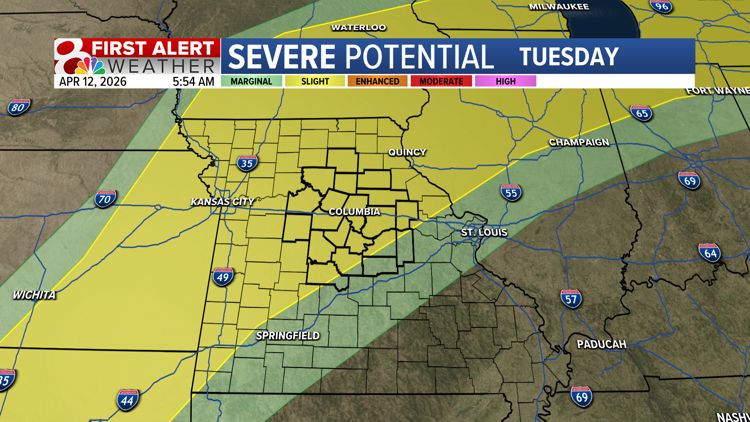
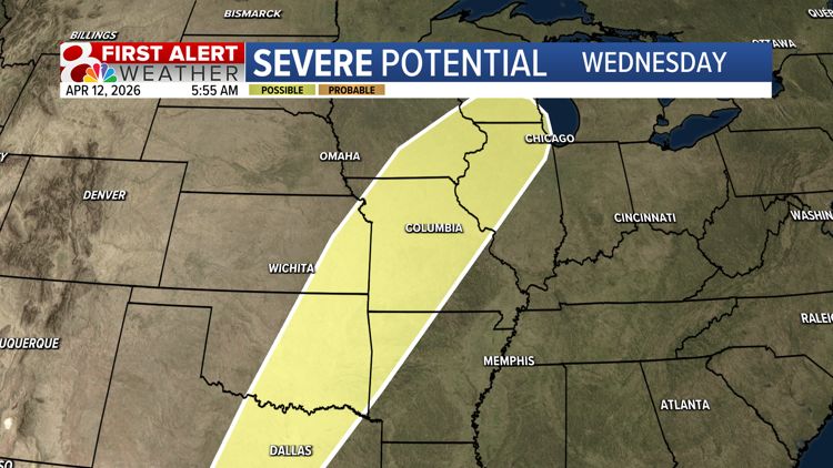
SEVERE POTENTIAL: We are tracking the possibility of some stronger storms on Tuesday and Wednesday. Still a lot of questions about who gets the worst of it. You'll want to stay tuned to the forecast. #mowx #midmowx #komuwx

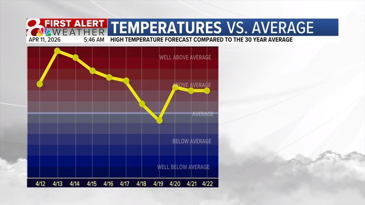
TEMPERATURE SWINGS: Above average temperatures are the story to start the week, before a cold front sweeps through and brings temperatures back to near average. I'll break down how this impacts your week on @KOMUNews at 6! #mowx #midmowx #komuwx
ACTIVE PATTERN AHEAD: Rain chances will be up and down through the week, with our best chances on Tuesday. A stronger storm or two can't be ruled out on Tuesday or Wednesday, but there are still many questions about just how strong those storms will be. #mowx #midmowx #komuwx
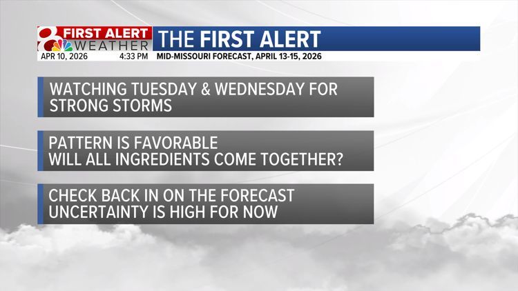
FIRST ALERT: Strong storms are possible on Tuesday & Wednesday. While the large scale pattern is favorable, there are still questions about whether all of the small scale ingredients will come together. I'll have the latest on @KOMUNews at 6! #mowx #midmowx #komuwx
THE WEEKEND AHEAD: On and off rain chances are expected this weekend, but there will still be dry time throughout both Saturday and Sunday. A few rumbles of thunder are possible, but no severe weather is expected. #mowx #midmowx #komuwx
ACTIVE WEEKEND: We just came out of an active pattern, and will be dry for a few days yet, but a more active pattern, along with thunderstorm chances returns this weekend. I'll have the details on @KOMUNews at 5! #mowx #midmowx #komuwx

MILD MONDAY: With lows in the 40s, and highs in the 60s, Monday will feel like a typical spring day for mid-Missouri. This won't stick around for long through, I'll break down the next pattern flip on @KOMUNews at 5! #mowx #midmowx #komuwx

FROST/FREEZE: Monday night into Tuesday morning temperatures could cool to near freezing for many, and perhaps below freezing in our northern most counties. I'll tell you everything you need to know about the week ahead on @KOMUNews at 5! #mowx #midmowx #komuwx
THUNDERSTORMS: Late this week and into the weekend thunderstorm potential is expected to continue. Strong storms are possible both Thursday and Friday, but we are not yet confident enough to issue a First Alert Weather Day. #mowx #midmowx #komuwx

RECORD WATCH: Highs in the middle to upper 80s will easily break the record high for today set all the way back in 1967. This record warmth won't stay for long, though. A cooler and rainy pattern begins Tuesday. #mowx #midmowx #komuwx

More record warmth? That's what we are forecasting this Thursday, with us once again nearing the 90s. If you have outdoor activities, let's make sure we're staying hydrated and taking time to cool off when needed. #mowx #midmowx #komuwx
THE WEEKEND AHEAD: On and off rain chances are expected this weekend, but there will still be dry time throughout both Saturday and Sunday. A few rumbles of thunder are possible, but no severe weather is expected. #mowx #midmowx #komuwx
RAIN TOTALS: Last night's storms brought quite a lot of rainfall for much of Mid-Missouri. Sedalia takes the cake with 2.60". A silver lining after a rough night for many is that the next few days will be sunny and nice. #mowx #midmowx #komuwx
THUNDERSTORMS: Late this week and into the weekend thunderstorm potential is expected to continue. Strong storms are possible both Thursday and Friday, but we are not yet confident enough to issue a First Alert Weather Day. #mowx #midmowx #komuwx
RECORD WARMTH EXPECTED: As we near Thursday, we currently forecast the high to break the record set back in 1910. While the forecast can change, confidence is high in temperatures nearing 90 as we round off the work week. #mowx #midmowx #komuwx
TUESDAY STORMS: Our partners at the Storm Prediction Center do not currently have us in a severe weather risk for Tuesday. While a 1/5 risk for damaging wind gusts could be introduced, we don't expect any major problems. #mowx #midmowx #komuwx
ABUNDANT RAIN: We expect that it will rain often Tuesday - Friday. The bad news is that dreary, inconvenient weather is likely. The good news is that this will likely get rid of any remaining drought concerns in Mid-Missouri. #mowx #midmowx #komuwx
ACTIVE WEEKEND: We just came out of an active pattern, and will be dry for a few days yet, but a more active pattern, along with thunderstorm chances returns this weekend. I'll have the details on @KOMUNews at 5! #mowx #midmowx #komuwx
ACTIVE PATTERN AHEAD: Rain chances will be up and down through the week, with our best chances on Tuesday. A stronger storm or two can't be ruled out on Tuesday or Wednesday, but there are still many questions about just how strong those storms will be. #mowx #midmowx #komuwx
THE FIRST ALERT: A First Alert Weather Day is in place for this afternoon and this evening. Large hail, damaging wind gusts, and a spin-up tornado or two are all possible today. I'll have the latest on @KOMUNews at noon. #mowx #midmowx #komuwx
TEMPERATURE SWINGS: Above average temperatures are the story to start the week, before a cold front sweeps through and brings temperatures back to near average. I'll break down how this impacts your week on @KOMUNews at 6! #mowx #midmowx #komuwx
FIRST ALERT: Strong storms are possible on Tuesday & Wednesday. While the large scale pattern is favorable, there are still questions about whether all of the small scale ingredients will come together. I'll have the latest on @KOMUNews at 6! #mowx #midmowx #komuwx
SUNSHINE AHEAD: After an active pattern, the weather in Mid-Missouri is expected to settle down for once. This won't last long though, as a more active pattern returns sooner rather than later. I'll tell you when on @KOMUNews at 9 and 10! #mowx #midmowx #komuwx
DROUGHT UPDATE: Strong storms are never good news, but at least they help relieve drought. Mid-Missouri isn't in drought of any kind right now, and with only a short period of dry time expected, drought concerns will remain at bay. #mowx #midmowx #komuwx
NICE MONDAY: Temperatures starting in the 50s and warming to the 80s make it feel more like May than March. This will be the warmest day we see for a while. #mowx #midmowx #komuwx
DRY TIME: After how active late last week was, this dry time is a welcome change. It won't last long, though, as thunderstorm chances return late next week. #mowx #midmowx #komuwx
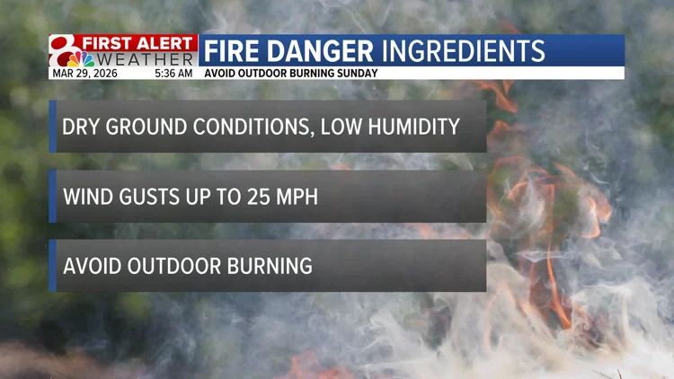
AVOID OUTDOOR BURNING TODAY: Dry, breezy conditions mean that fires are more prone to erratic behavior, making them harder to control. #mowx #midmowx #komuwx
RAINY WEEK AHEAD: Tuesday will be the start of a wet period. Heavy rain and storms are expected Tuesday night, before we see lighter on and off showers for the remainder of the week. I'll tell you how much rain we expect on @KOMUNews at 5, 9, and 10! #mowx #midmowx #komuwx
Something went wrong.
Something went wrong.
United States Trends
- 1. Cade N/A
- 2. Pistons N/A
- 3. #WWERaw N/A
- 4. Duren N/A
- 5. Spencer Jones N/A
- 6. Devin Booker N/A
- 7. Jamal Cain N/A
- 8. Magic N/A
- 9. #bucciovertimechallenge N/A
- 10. Desmond Bane N/A
- 11. #ThunderUp N/A
- 12. Naz Reid N/A
- 13. Tobias Harris N/A
- 14. Jalen Suggs N/A
- 15. Game 6 N/A
- 16. World War Eleven N/A
- 17. Christian Braun N/A
- 18. Kimmel N/A
- 19. Tyus Jones N/A
- 20. Franz N/A