#latesttutorial ผลการค้นหา

#LatestTutorial in the #LearnArcGIS Series Title: DIGITIZING (Creating Vector Data) In this video, we are going to be learning how to Digitize data that is to be able to create our own Vector Data sets. We will use two methods:

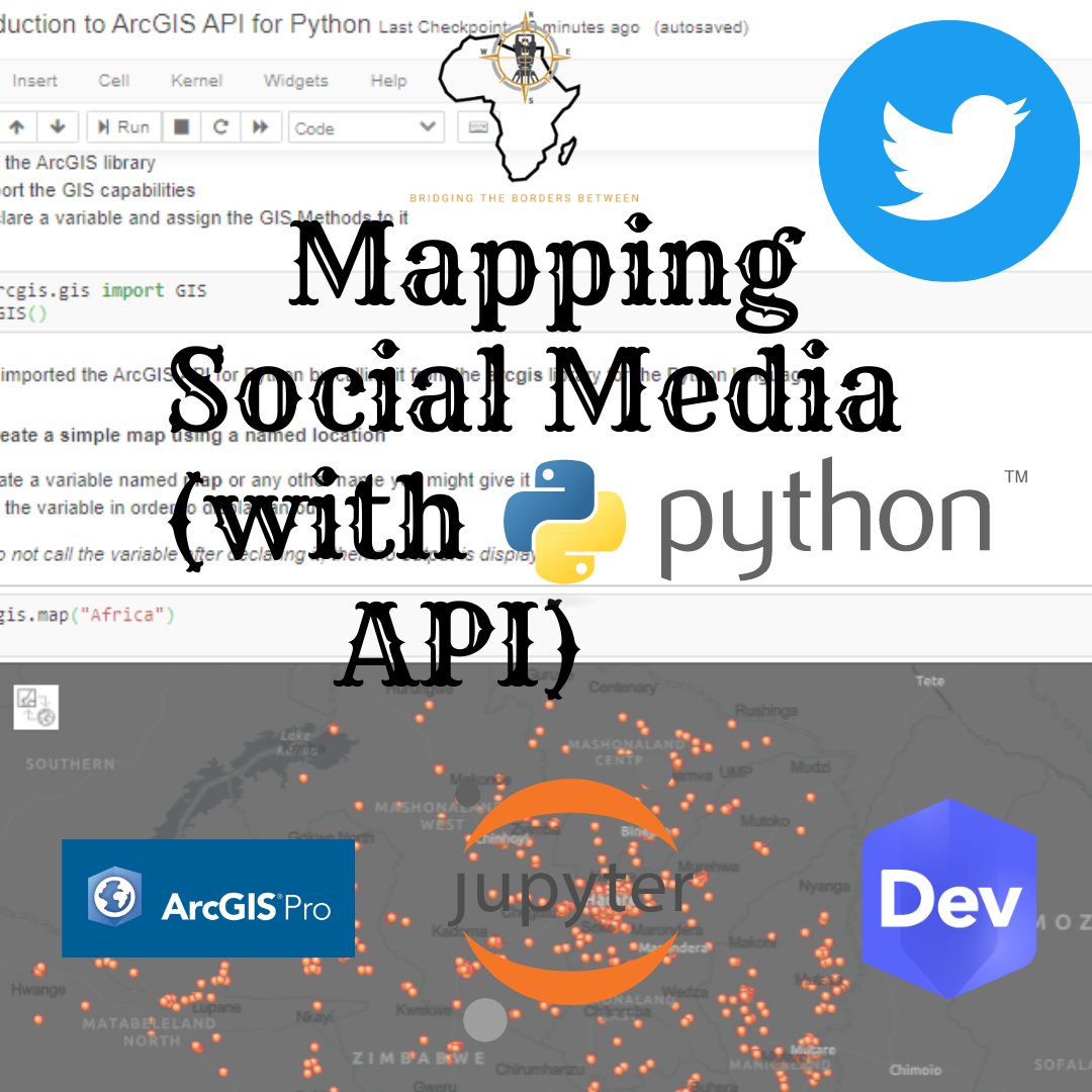
#LatestTutorial in the #LearnArcGIS series. Titled: Mapping Social Media In this latest tutorial from the #LearnArcGIS series, we are going to be doing some #DataMining over social media. We will be using Twitter for this tutorial. #tweepy #Python

Latest & Awesome Illustrator Tutorials to Improve Yore Illustrator Art blog.karachicorner.com/2018/08/latest… #illustratortutorial #latesttutorial #awesometutorial #artdesign #illustratorart

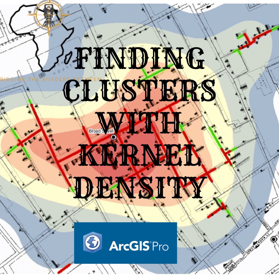
#LatestTutorial in the #LearnArcGIS series Title: IDENTIFYING CLUSTERS WITH THE KERNEL DENSITY ALGORITHM Back to 1854, we are going to be using the same model used by Jon Snow to identify the cause of the Cholera outbreak in London. youtu.be/FQOlY8piEg8
#LatestTutorial in the #LearnArcGIS series Title: Defining Distance with Buffers Next video in the #LearnArcGIS we are going to be going through how we can create buffers and how the 3 different types of Buffering works. youtu.be/irkQ3afUpdE

#LatestTutorial in the #LearnArcGIS series. Title: GETTING DATA FROM THE LIVING ATLAS INTO AN ArcGIS PRO PROJECT You might want to borrow a few data sets which have been made public over the #LivingAtlas platform in order to complete your project. youtu.be/rAvyZa9OJGU

#LatestTutorial in the #LearnArcGIS tutorial series Title: INTRODUCTION TO ARCGIS API FOR #Python For those without #ArcPro licensed software you can use the alternative which is #JupyterNotebooks and download and install the API Learn how—> youtu.be/572QvhSUhmM

#LatestTutorial in our #LearnArcGIS tutorial series. Title: SYMBOLIZING & LABELING YOUR DATA IN ARCGIS PRO Next up in our Learn ArcGIS tutorial series, we are going to be going over how you can Symbolize and Label your data for visualization purposes. youtu.be/xw3CtCX8KHs
#LatestTutorial in the #ArcGISPro series Title: Synchronizing Your Workflow in ArcGIS Pro & ArcGIS Online Synchronization of data is kep especially when you want to provide real-time data to the group of individuals that you decide to share with. youtu.be/5ARBh0tqQzY/
#LatestTutorial in the #LearnArcGIS tutorial. Title: INTRODUCTION TO ARCGIS NOTEBOOKS In this introduction video tutorial we will be introducing you to the ArcGIS Notebooks user interface and the Pandas #Python library for #DataScience. youtu.be/1u4UlbhKrbs
#LatestTutorial in the #LearnArcGIS series. Titled: Mapping Social Media In this latest tutorial from the #LearnArcGIS series, we are going to be doing some #DataMining over social media. We will be using Twitter for this tutorial. #tweepy #Python
#LatestTutorial in the #LearnArcGIS tutorial series Title: INTRODUCTION TO ARCGIS API FOR #Python For those without #ArcPro licensed software you can use the alternative which is #JupyterNotebooks and download and install the API Learn how—> youtu.be/572QvhSUhmM
#LatestTutorial in the #LearnArcGIS tutorial. Title: INTRODUCTION TO ARCGIS NOTEBOOKS In this introduction video tutorial we will be introducing you to the ArcGIS Notebooks user interface and the Pandas #Python library for #DataScience. youtu.be/1u4UlbhKrbs
#LatestTutorial in the #LearnArcGIS Series Title: DIGITIZING (Creating Vector Data) In this video, we are going to be learning how to Digitize data that is to be able to create our own Vector Data sets. We will use two methods:
#LatestTutorial in the #LearnArcGIS series Title: Defining Distance with Buffers Next video in the #LearnArcGIS we are going to be going through how we can create buffers and how the 3 different types of Buffering works. youtu.be/irkQ3afUpdE
#LatestTutorial in the #LearnArcGIS series Title: IDENTIFYING CLUSTERS WITH THE KERNEL DENSITY ALGORITHM Back to 1854, we are going to be using the same model used by Jon Snow to identify the cause of the Cholera outbreak in London. youtu.be/FQOlY8piEg8
#LatestTutorial in the #LearnArcGIS series. Title: GETTING DATA FROM THE LIVING ATLAS INTO AN ArcGIS PRO PROJECT You might want to borrow a few data sets which have been made public over the #LivingAtlas platform in order to complete your project. youtu.be/rAvyZa9OJGU
#LatestTutorial in our #LearnArcGIS tutorial series. Title: SYMBOLIZING & LABELING YOUR DATA IN ARCGIS PRO Next up in our Learn ArcGIS tutorial series, we are going to be going over how you can Symbolize and Label your data for visualization purposes. youtu.be/xw3CtCX8KHs
#LatestTutorial in the #ArcGISPro series Title: Synchronizing Your Workflow in ArcGIS Pro & ArcGIS Online Synchronization of data is kep especially when you want to provide real-time data to the group of individuals that you decide to share with. youtu.be/5ARBh0tqQzY/
Latest & Awesome Illustrator Tutorials to Improve Yore Illustrator Art blog.karachicorner.com/2018/08/latest… #illustratortutorial #latesttutorial #awesometutorial #artdesign #illustratorart


#LatestTutorial in the #LearnArcGIS Series Title: DIGITIZING (Creating Vector Data) In this video, we are going to be learning how to Digitize data that is to be able to create our own Vector Data sets. We will use two methods:
Latest & Awesome Illustrator Tutorials to Improve Yore Illustrator Art blog.karachicorner.com/2018/08/latest… #illustratortutorial #latesttutorial #awesometutorial #artdesign #illustratorart
#LatestTutorial in the #LearnArcGIS series. Titled: Mapping Social Media In this latest tutorial from the #LearnArcGIS series, we are going to be doing some #DataMining over social media. We will be using Twitter for this tutorial. #tweepy #Python
#LatestTutorial in the #LearnArcGIS series Title: IDENTIFYING CLUSTERS WITH THE KERNEL DENSITY ALGORITHM Back to 1854, we are going to be using the same model used by Jon Snow to identify the cause of the Cholera outbreak in London. youtu.be/FQOlY8piEg8
#LatestTutorial in the #LearnArcGIS series Title: Defining Distance with Buffers Next video in the #LearnArcGIS we are going to be going through how we can create buffers and how the 3 different types of Buffering works. youtu.be/irkQ3afUpdE
#LatestTutorial in the #LearnArcGIS tutorial series Title: INTRODUCTION TO ARCGIS API FOR #Python For those without #ArcPro licensed software you can use the alternative which is #JupyterNotebooks and download and install the API Learn how—> youtu.be/572QvhSUhmM
#LatestTutorial in the #LearnArcGIS series. Title: GETTING DATA FROM THE LIVING ATLAS INTO AN ArcGIS PRO PROJECT You might want to borrow a few data sets which have been made public over the #LivingAtlas platform in order to complete your project. youtu.be/rAvyZa9OJGU
Something went wrong.
Something went wrong.
United States Trends
- 1. Yamamoto 38.6K posts
- 2. #DWTS 39.4K posts
- 3. Brewers 40.1K posts
- 4. Ohtani 13.3K posts
- 5. #Dodgers 15.2K posts
- 6. #DWCS 7,392 posts
- 7. #WWENXT 18K posts
- 8. Robert 105K posts
- 9. #RHOSLC 4,151 posts
- 10. Young Republicans 62.5K posts
- 11. Haji Wright 1,050 posts
- 12. Carrie Ann 4,662 posts
- 13. Roldan 2,470 posts
- 14. Politico 285K posts
- 15. Elaine 60.3K posts
- 16. Whitney 15.4K posts
- 17. Will Richard 2,461 posts
- 18. Yelich 1,731 posts
- 19. Max Muncy 4,334 posts
- 20. bush 36.9K posts