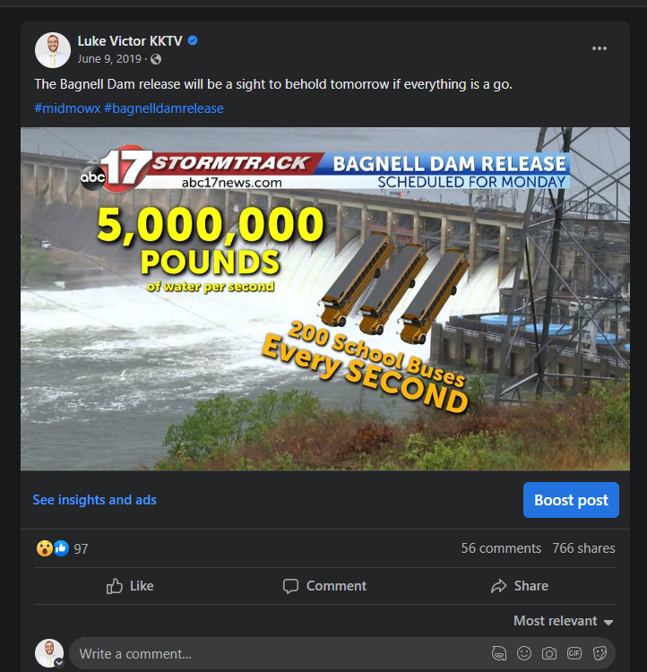
#midmowx resultados de búsqueda

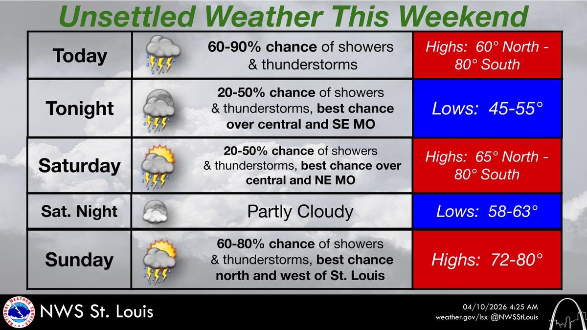
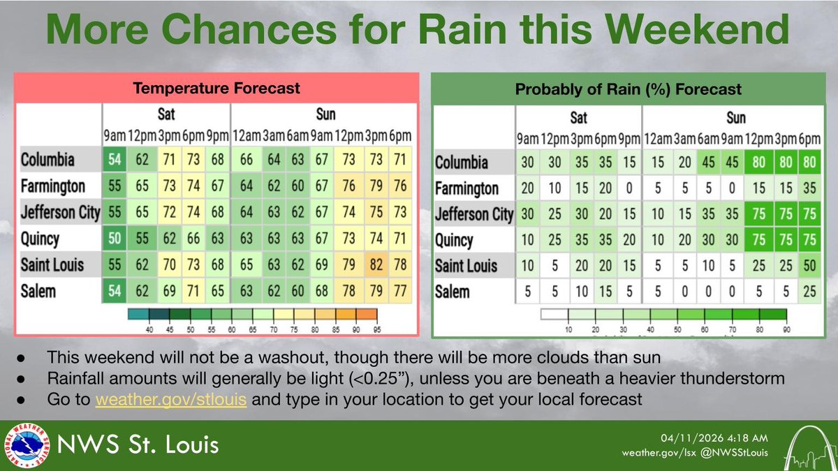
An active weather pattern will bring multiple chances of showers and thunderstorms this weekend, especially today and Sunday. Go to weather.gov/stlouis and type in your location to get your local forecast. #stlwx #midmowx #ilwx #mowx

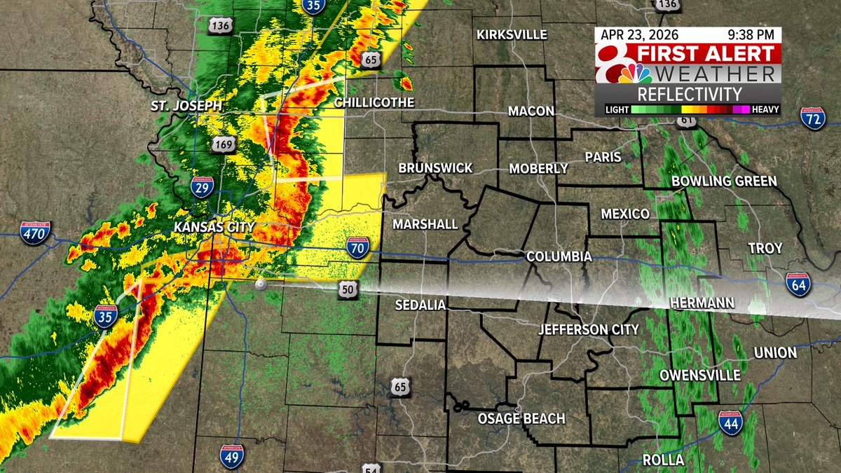
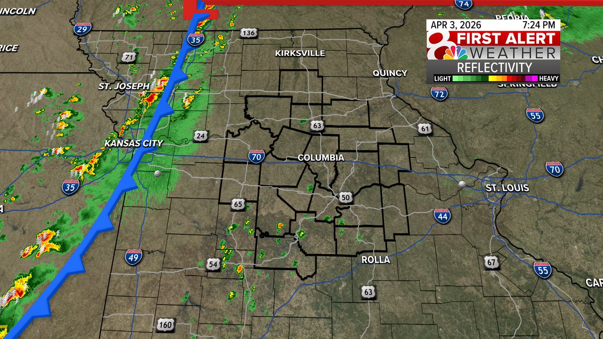
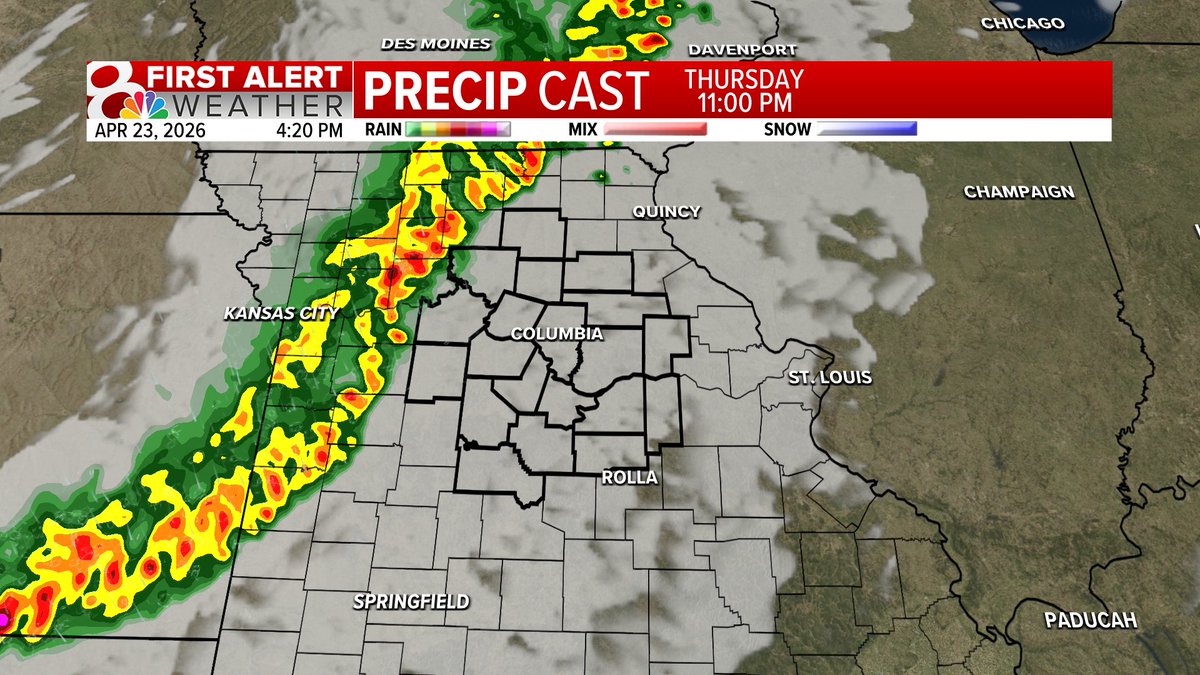
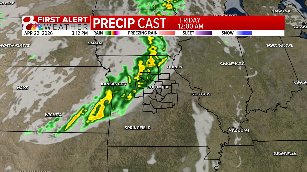
9:38PM Thursday Radar: Watching storms coming out of the KC Area. These have been pretty nasty and have even had some rotation over the last hour or so. These are starting to weaken as they move closer to our region. Watching for a few 40-60 mph wind gusts. #MidMoWx #MoWx
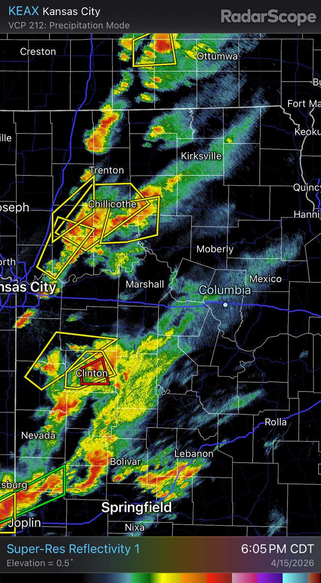
6PM Radar: Two clusters of storms to watch right now. The northern cluster is a little more messy, but still capable of strong winds and large hail. The southern storms are a bit more organized, all forms of severe weather possible. Both clusters of storms are moving NE. #MidMoWx
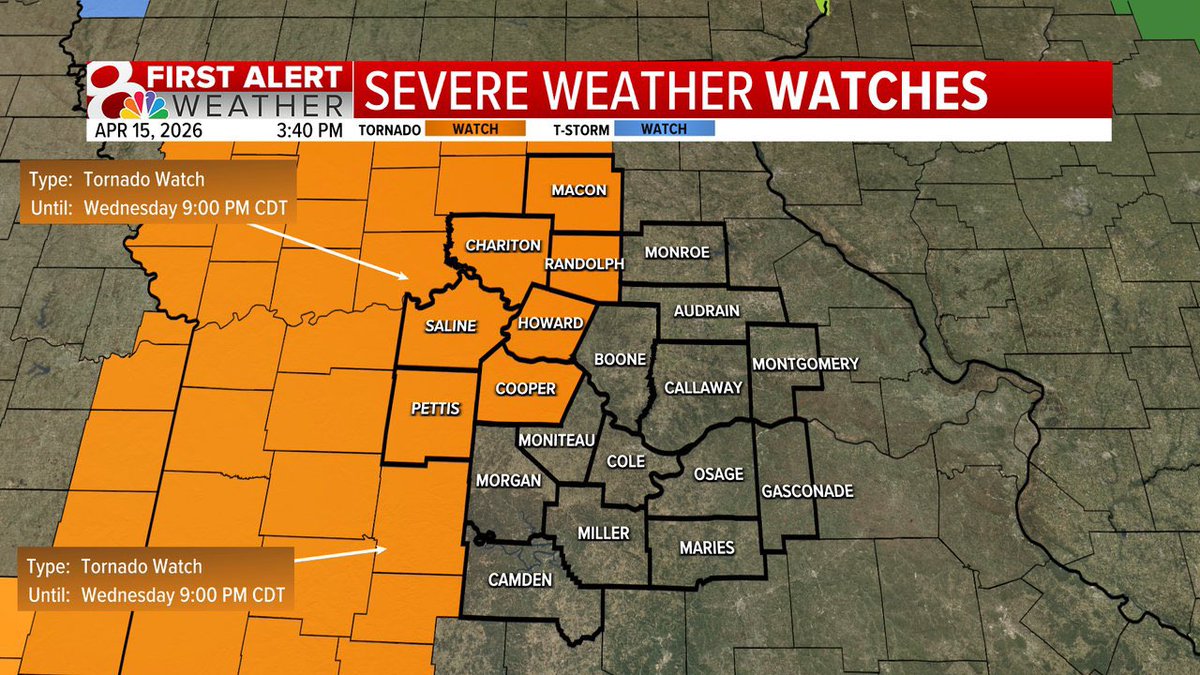
WEDNESDAY 6:50PM UPDATE: The tornado watch has been expanded to include all of Mid-Missouri until midnight. The main threat remains hail and damaging winds,but a tornado or two can’t be ruled out. @kesley_wx & @ethanbeanwx will keep you updated on KOMU 8. #MidMoWx #MoWx
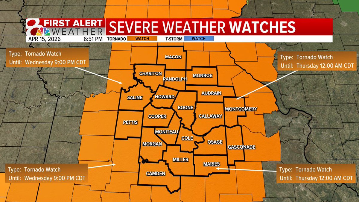
A Tornado Watch for areas along and west of Highway 63 until 9PM Wednesday. While the tornado watch is in effect and a few tornadoes are possible, the main threats remain to be large hail and damaging winds. @kesley_wx & @ethanbeanwx will keep you updated #MidMowx #Mowx #MidMo
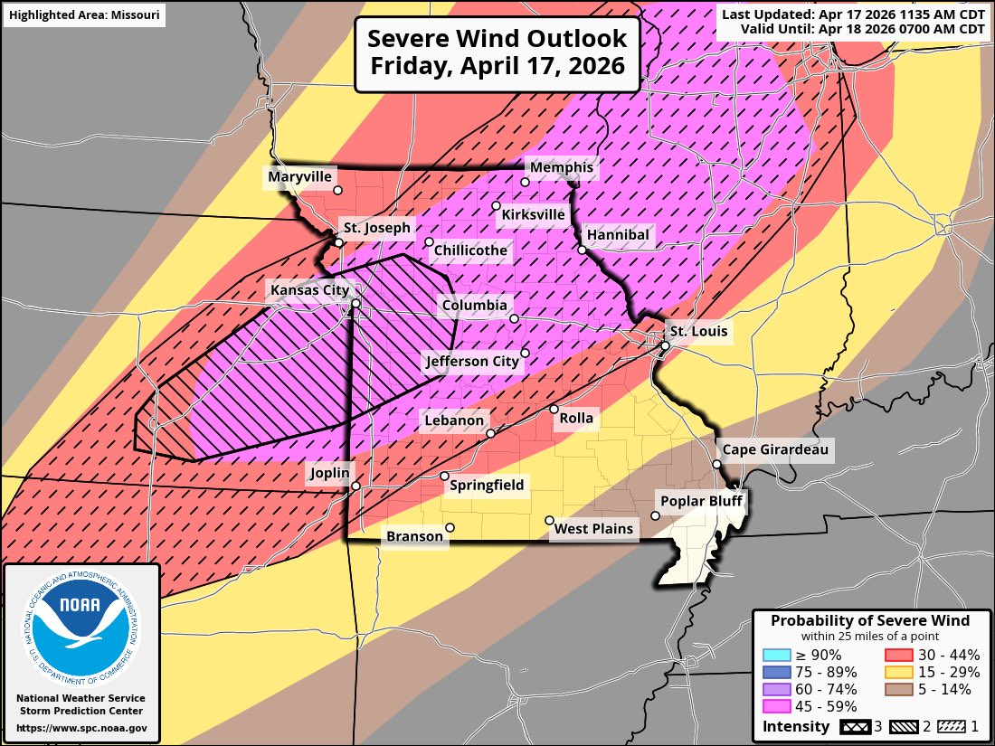
FRIDAY UPDATE: The Storm Prediction Center just upgraded to a moderate (4/5) risk from roughly Marshall /Sedalia stretching southwest to KC into Ks. This is a wind driven upgrade. Wind gusts in the worst storms could be over 80MPH especially in the red area. #MidMoWx #MoWx

Temperatures will drop down into the 30s across the area on Monday night including a high chance (50 to 80 percent) of freezing temperatures over parts of northeast Missouri. Outdoor plants should be covered or brought inside away from the cold. #stlwx #midmowx #mowx #ilwx

7:30PM Friday: Storms have had a hard time sustaining themselves out to our west near the cold front. This is good news and a trend in the right direction. Severe threat is still there, but already starting to trend lower. I'm on duty tonight until the threat ends! #MidMoWx #MoWx

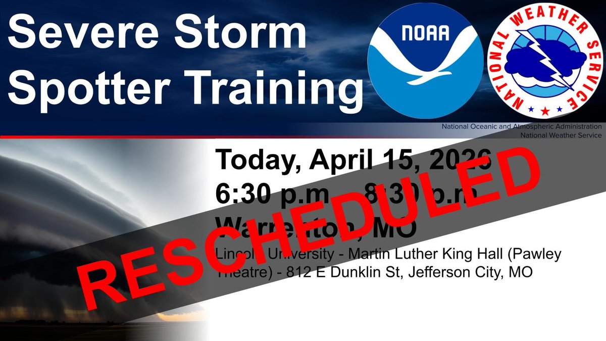
Update: The Storm Spotter Training session that was cancelled on April 15 has been rescheduled for April 21. See the graphic for details! #mowx #midmowx

There will be scattered showers and a few thunderstorms across the area this weekend, with the best chance across central and NE MO and west central IL on Sunday afternoon. Temperatures will be warmer across the area on Sunday behind a warm front. #stlwx #midmowx #mowx #ilwx
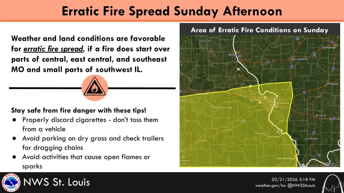
Erratic fire conditions are likely again on Sunday afternoon from a combination of strong winds and low humidity. Leave burning to the professionals and reduce the risk for open flames and sparks. #stlwx #midmowx #ilwx #mowx
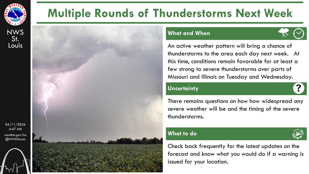
An active weather pattern will bring a chance of showers and thunderstorms to the area next week. There is the potential for a few strong to severe thunderstorms on Tuesday and Wednesday, so make sure you to check back for future updates. #stlwx #midmowx #ilwx #mowx


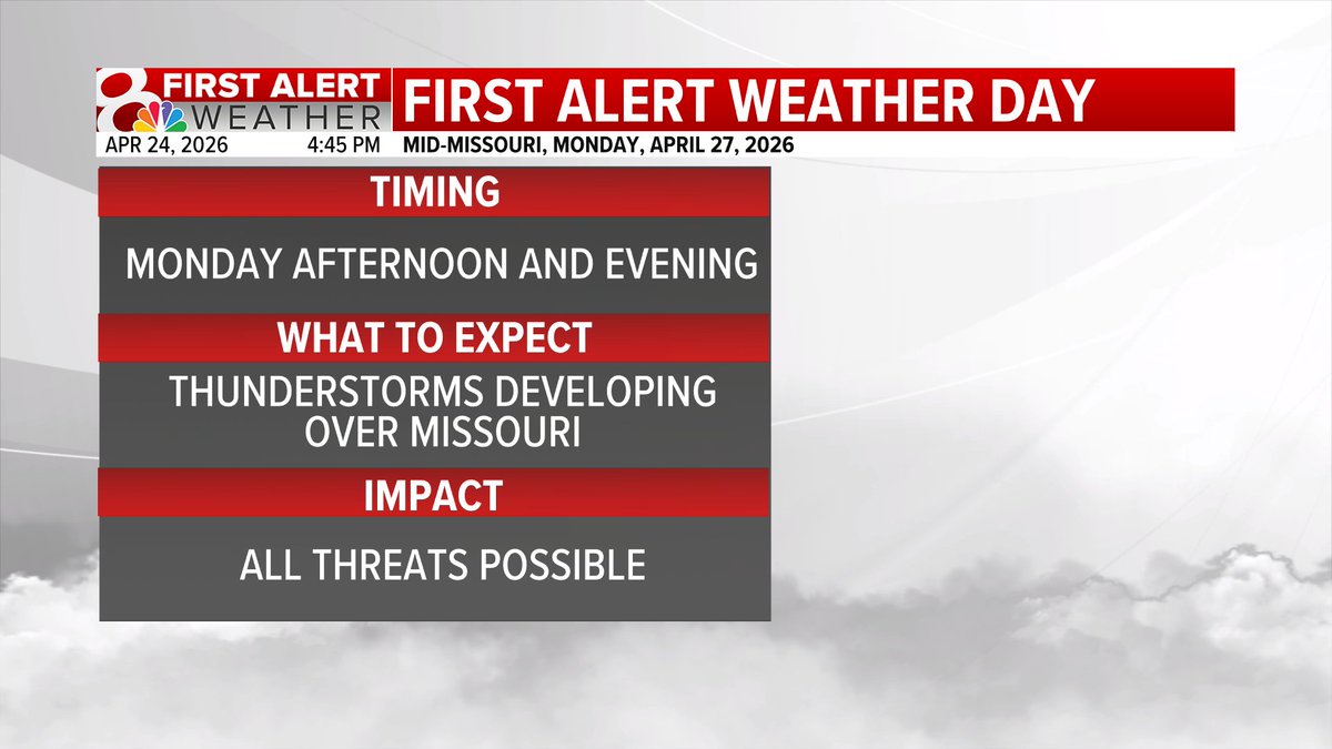
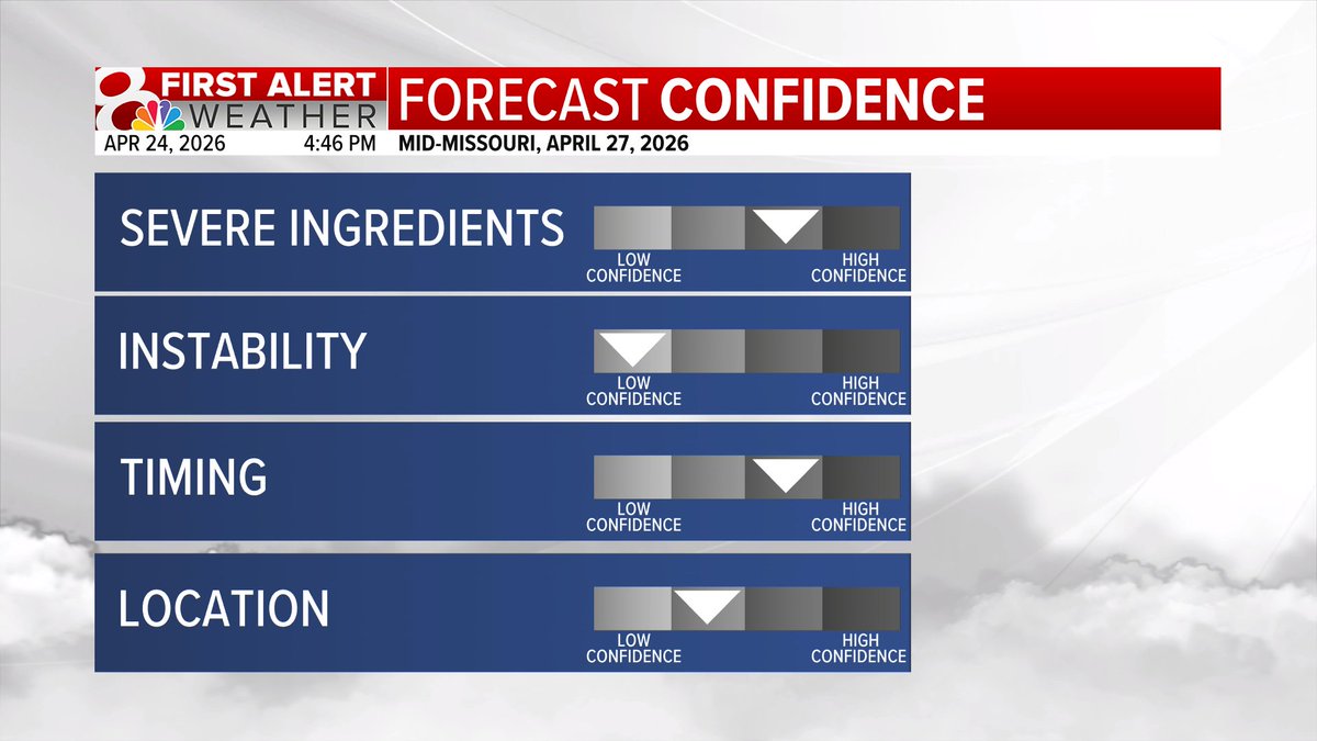
MONDAY STORMS: Monday will be our next First Alert Weather Day. There are still a lot of details that need to be ironed out, including just how far west the potential for severe weather extends. Check back in with the forecast throughout the weekend. #midmowx #midmo #mowx

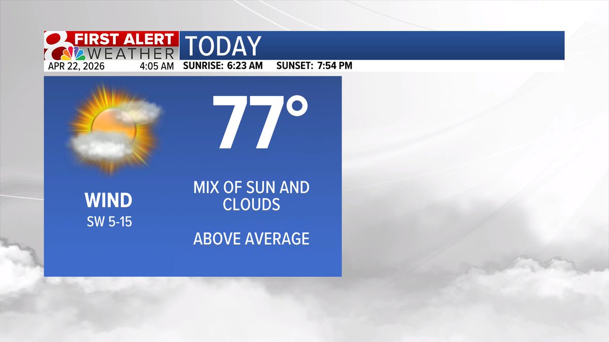
Friday Morning: The rain is done and clouds will clear late this morning into the afternoon. Highs in the 70s today. #MidMoWx #MoWx #MidMo

FIRST ALERT: Rain chances late Sunday into Monday will bring the potential for strong to severe storms. Exact timing is key & still very uncertain at this time. There are still a lot of questions about this round of rain. Stay tuned. #midmowx #midmo #mowx @KOMUnews

FRIDAY: Temperatures will climb into the middle 70s with decreasing clouds this afternoon. Winds will be out of the northwest at 5-15 mph. #midmowx #midmo #mowx @KOMUnews

HEADLINES: Good morning and happy Friday! Rain is moving out this morning, leaving behind cloudy skies for the morning commute. We will see decreasing clouds throughout the day with highs in the 70s. We are trending dry for most of the weekend. #midmowx #midmo #Mowx @KOMUnews

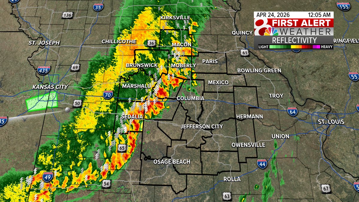
12:05AM Thursday Night/Friday Morning: Storms continue to inch into Mid-Missouri and they are continuing to show signs of weakening. Still keeping an eye on everything, but I'm liking the trend we're on. #MidMoWx #MoWx #MidMo
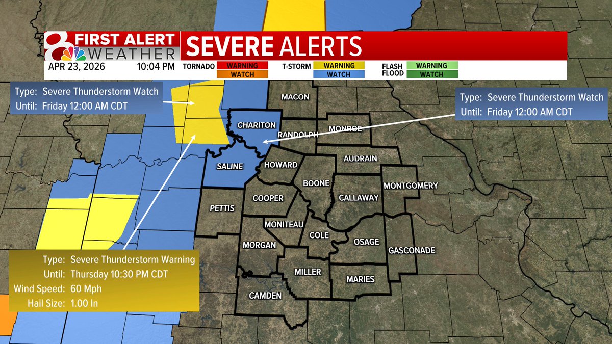
A Tornado Warning is in effect until 4/23 11:30PM for Henry, Johnson, Pettis County. Please take shelter and tune into KOMU 8 for live coverage. #MoWx #MidMoWx
A Severe Thunderstorm Watch is in effect for Chariton and Saline County until Midnight. That is where our near-term severe potential is over the next half hour to an hour. #MidMoWx #MoWx #MidMo
9:38PM Thursday Radar: Watching storms coming out of the KC Area. These have been pretty nasty and have even had some rotation over the last hour or so. These are starting to weaken as they move closer to our region. Watching for a few 40-60 mph wind gusts. #MidMoWx #MoWx
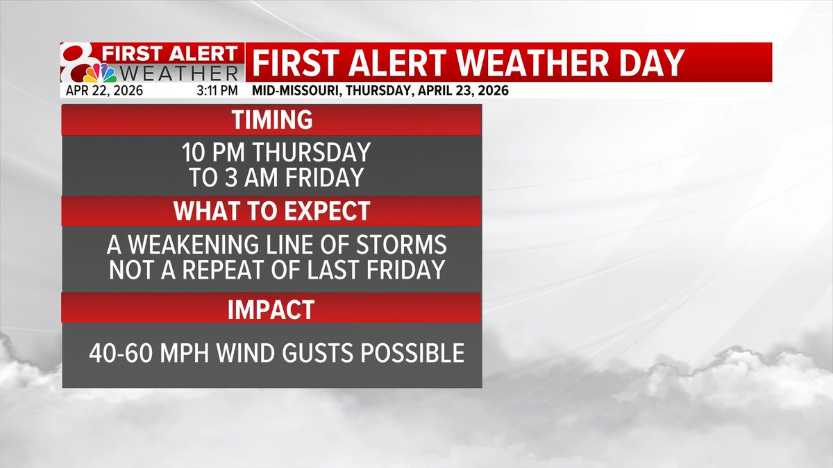
Thursday Night/Friday Morning: Storm Timeline: A weakening line of showers and thunderstorms will move through the region tonight and could produce a few 40-60 mph wind gusts. Overall, severe threat is on the lower side, but one or two severe storms are possible. #MidMoWx #MoWx


FIRST ALERT: Thursday night/early Friday morning will be a First Alert Weather Day as a weakening line of storms will move through mid-MO. This will NOT be a repeat of last Friday, but more similar to other storm chances earlier this spring. #midmowx #Midmo #Mowx


Midday Wednesday: Hoping for some sunshine this afternoon, but cloud cover has been pretty persistent. #MidMoWx #MoWx #MidMo

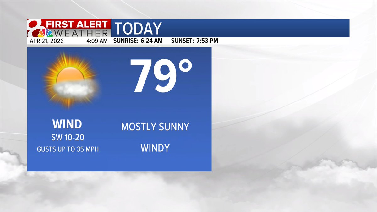
WEDNESDAY: Temperatures will climb into the upper 70s under a mix of sun and clouds. Winds will be out of the southwest at 5-15 mph. #midmowx #midmo #mowx @KOMUnews
OUT THE DOOR temperatures are in the 50s, I would grab your light jacket and a hot coffee as you head out the door. #midmowx #midmo #mowx @KOMUnews


HEADLINES: Good morning and happy Wednesday! It is mild this morning with temperatures in the 60s. We climb into the upper 70s again this afternoon. Rain chances return very late Thursday into Friday. We are seasonal this weekend. More on @KOMUnews until 7AM! #midmowx #midmo

5PM Tuesday: Discovery Parkway is looking BUSY! Probably going to look like that a lot over the next few months with the northbound ramps at Grindstone and New Haven Road are closed due to construction. #MidMoWx #MoWx #MidMo

It's happening tonight! The last Storm Spotter Training for 2026 is tonight at 6:30 PM in at Lincoln University in Jefferson City, Missouri. Find out more at weather.gov/lsx/spottertal… #MoWx #IlWx #MidMoWx

TUESDAY: Temperatures will climb into the upper 70s under mostly sunny skies today. Winds will be out of the southwest at 10-20 mph, gusting up to 35 mph. #midmowx #midmo #mowx @KOMUnews
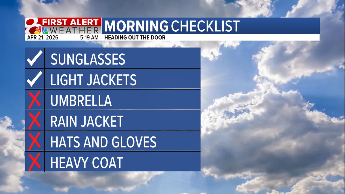
OUT THE DOOR temperatures are in the 50s, it's chilly! Grab your light jackets, a hot coffee, and your sunglasses! #midmowx #midmo #mowx @KOMUnews


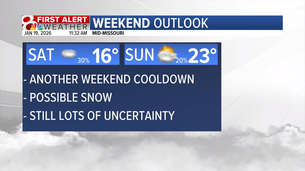
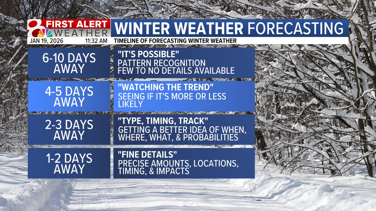
You may be seeing some buzz on social media about possible snow this weekend. It's definitely on my radar as something to watch but it's still too early to give exact details like timing, amounts, and location. Keep checking back through the week for updates. #midmowx #midmo
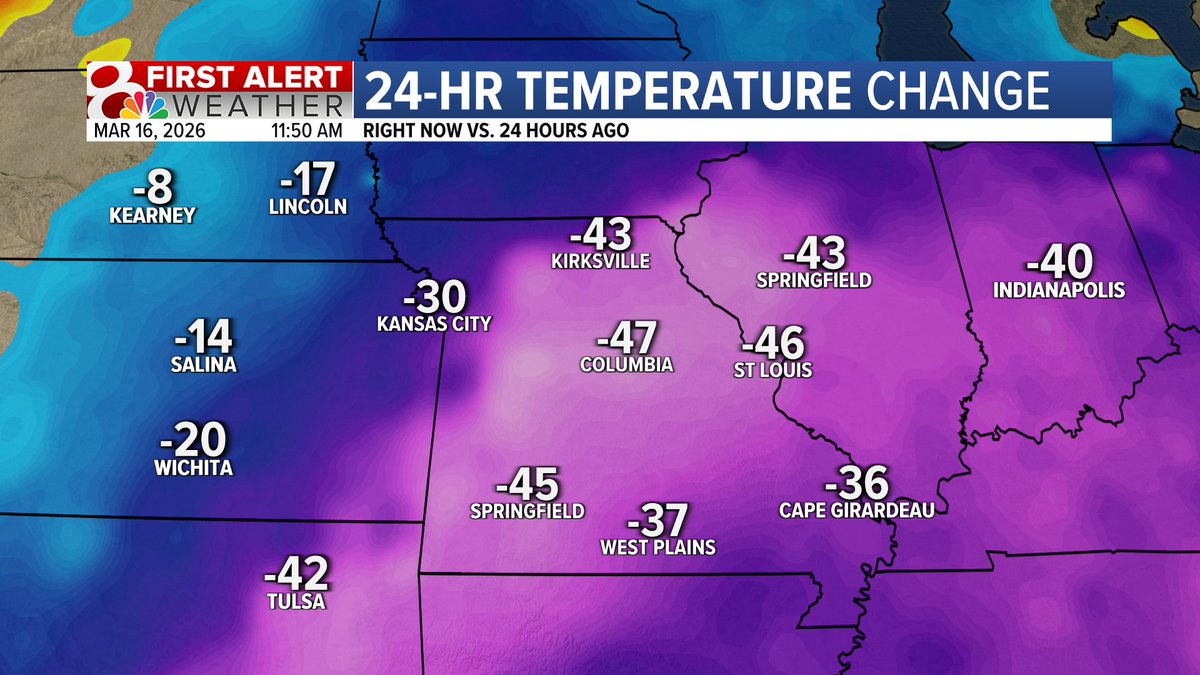
I spent several hours this weekend sitting on a patio with friends. Today, the lock on my car door was frozen shut. #midmowx #midmo #mowx
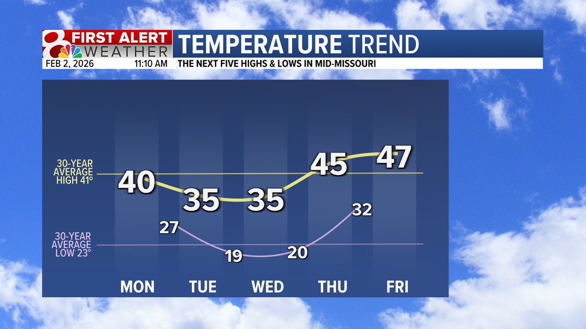
Phil may be saying six more weeks of winter, but I'm forecasting temps above freezing this week! Feeling much less winter-like than the past few weeks... #midmowx #midmo #mowx
MONDAY STORMS: Monday will be our next First Alert Weather Day. There are still a lot of details that need to be ironed out, including just how far west the potential for severe weather extends. Check back in with the forecast throughout the weekend. #midmowx #midmo #mowx
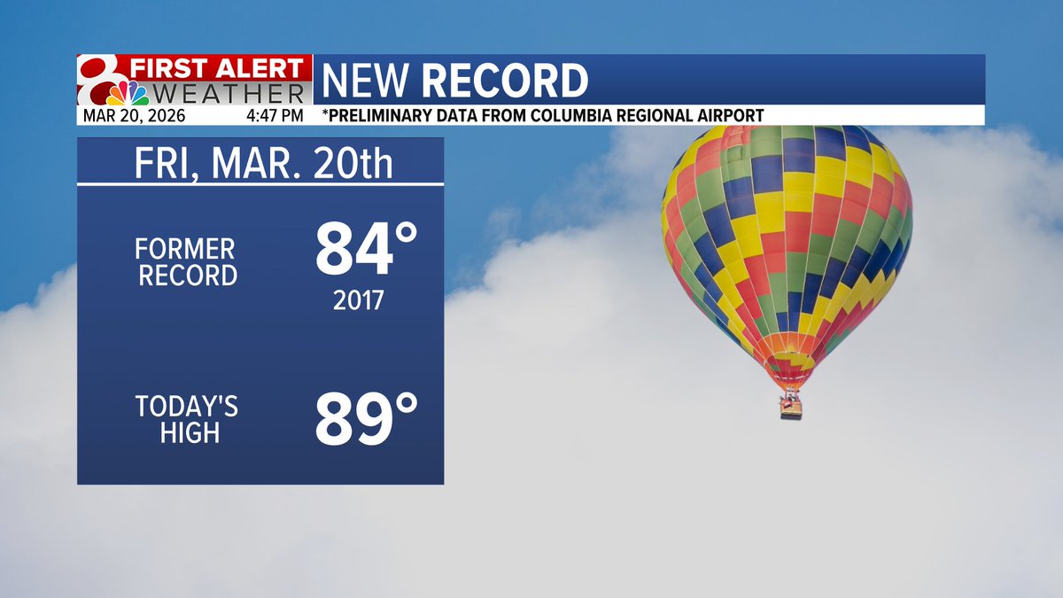
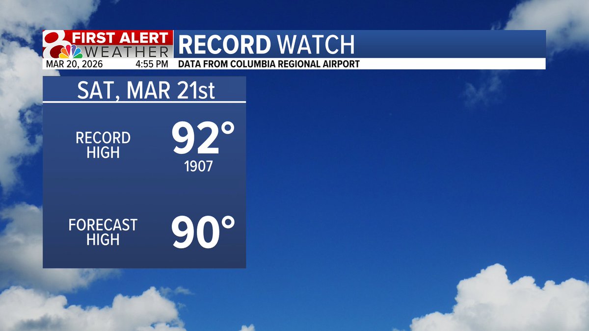
NEW RECORD! COU hit 89 degrees today breaking the previous record from 2017. There is another chance for nearing a temperature record tomorrow. #midmo #midmowx #midmo
Friday is a First Alert Weather Day for storms this evening and overnight. Most of Friday will be dry, warm, and breezy with isolated storms possible this afternoon and widespread storms past sunset. #midmowx #Midmo #Mowx

Yes we had two days in a row of 80+ degree temps. Yes wind chills will be in the teens Monday morning. #midmowx #midmo #mowx

5PM Tuesday: Discovery Parkway is looking BUSY! Probably going to look like that a lot over the next few months with the northbound ramps at Grindstone and New Haven Road are closed due to construction. #MidMoWx #MoWx #MidMo
UPDATE: An EF0 tornado has been confirmed by the National Weather Service during Friday's storms. The weather service says that it is likely that the tornado touched down and uplifted multiple times along the track. #MidMoWx #MoWx #MidMo

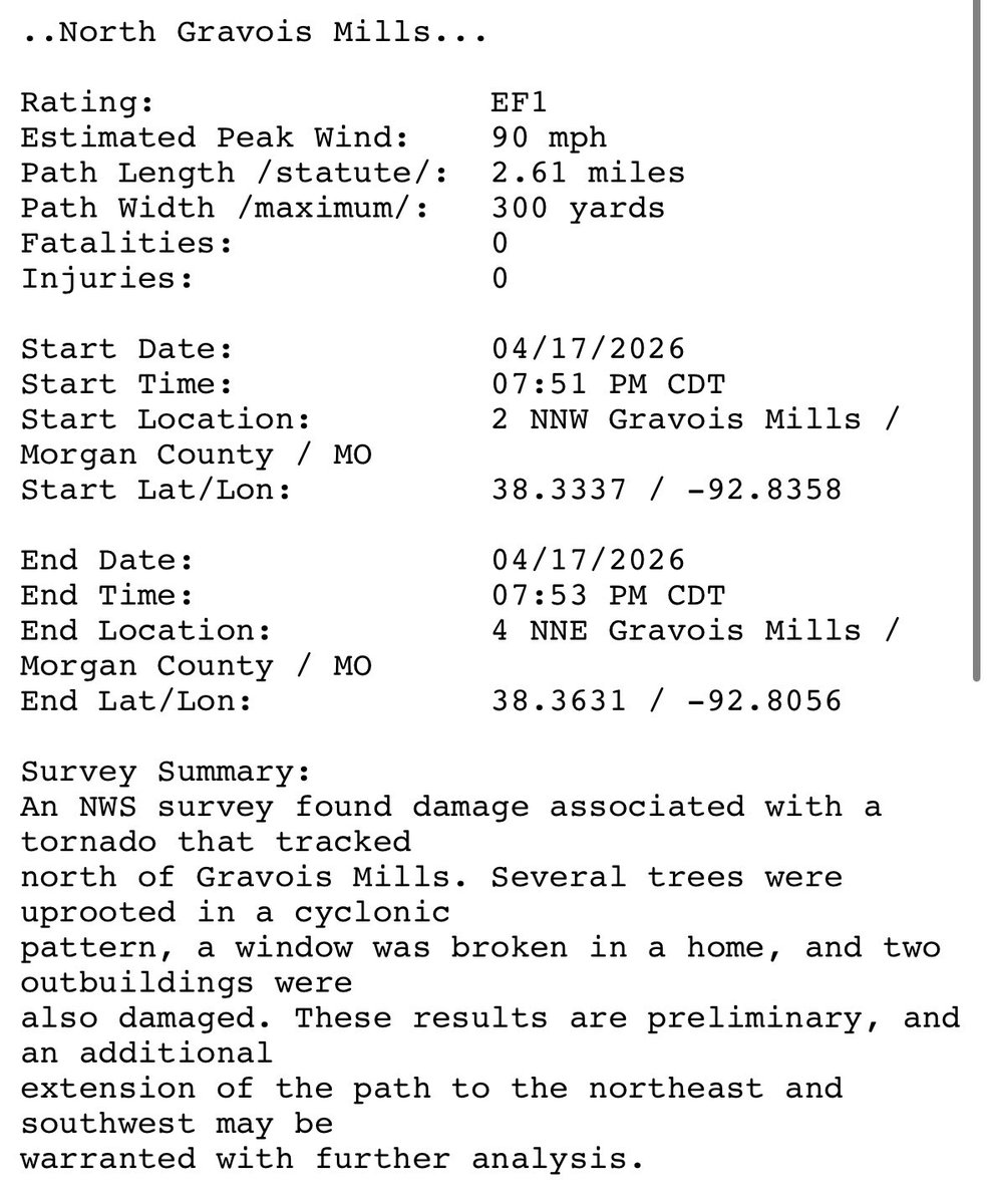
UPDATE: Two tornadoes have been confirmed from Friday’s storms in Morgan County. One tornado was near Gravois Mills and was rated as an EF1. Another tornado was confirmed near Barnett and was rated as an EF0. #MidMoWx #MoWx #MidMo


6PM Radar: Two clusters of storms to watch right now. The northern cluster is a little more messy, but still capable of strong winds and large hail. The southern storms are a bit more organized, all forms of severe weather possible. Both clusters of storms are moving NE. #MidMoWx
Cooler temperatures will start off the week. A reinforcing shot of colder air will bring low temperatures into the 30s and possibly the upper 20s in northern areas before temperatures begin warming by midweek. #stlwx #midmowx #mowx #ilwx

An active weather pattern will bring a chance of showers and thunderstorms to the area next week. There is the potential for a few strong to severe thunderstorms on Tuesday and Wednesday, so make sure you to check back for future updates. #stlwx #midmowx #ilwx #mowx
Something went wrong.
Something went wrong.
United States Trends
- 1. Dylan Harper N/A
- 2. Rockets N/A
- 3. Marcus Smart N/A
- 4. Lakers N/A
- 5. Bron N/A
- 6. #SmackDown N/A
- 7. #TheLastDriveIn N/A
- 8. Scoot N/A
- 9. Allar N/A
- 10. Kairi N/A
- 11. #LakeShow N/A
- 12. Carter Bryant N/A
- 13. Reed Sheppard N/A
- 14. McCoy N/A
- 15. #MutantFam N/A
- 16. Tanner Scott N/A
- 17. Bow Wow N/A
- 18. #FlyTogether N/A
- 19. Ducks N/A
- 20. Sengun N/A