#midmowx risultati di ricerca

TUESDAY STORMS: Our partners at the Storm Prediction Center do not currently have us in a severe weather risk for Tuesday. While a 1/5 risk for damaging wind gusts could be introduced, we don't expect any major problems. #mowx #midmowx #komuwx


Local legend is stepping away from tv. @WeatherZach, you are the epitome of a chief, especially for younger talent entering tv weather. From life lessons to life-changing moments shared while covering #midMOwx, those helped shape me into the meteorologist and person I am today.

When you grow up in a place like Oklahoma City, where the weather can just jump up and clobber you any time, you develop a respect for this group of people. Cheers! #MidMoWx


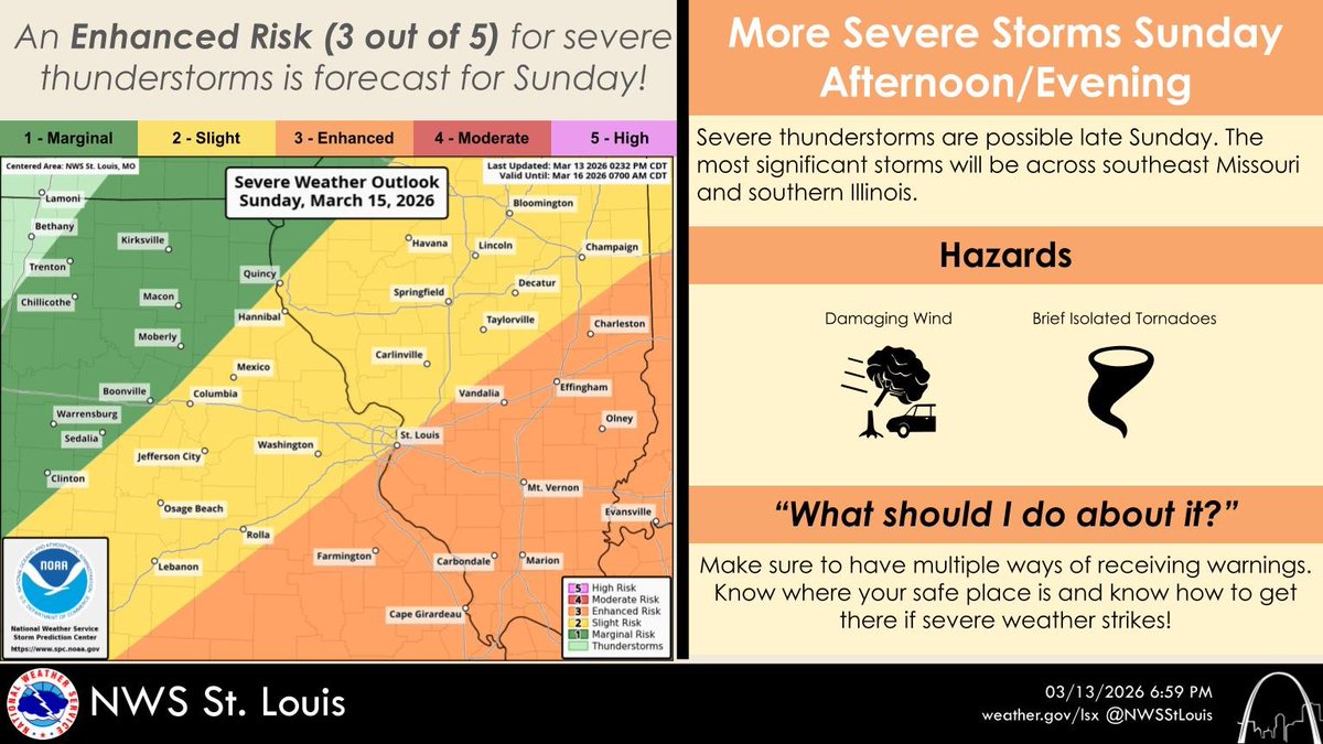
Sunday afternoon will bring an enhanced risk of severe weather along a strong cold front to the south of I-44, with a lesser risk farther north. #stlwx #midmowx #mowx #ilwx
Midday Thursday: A tornado watch will likely be issued in northern Missouri as well as parts of Iowa and Illinois later this afternoon. Main threat stays to the north of the KOMU 8 Viewing area. #MidMoWx #MoWx #MidMo


Erratic fire conditions will continue each afternoon through the end of the weekend from a combination of strong winds and low humidity. Leave burning to the professionals this weekend and reduce the risk for open flames and sparks. #MoWx #IlWx #MidMoWx #StlWx

Rain is exiting the area this morning, leaving cloudy and cooling conditions across the area. Clouds will clear out overnight and Sunday will be clear with warmer temperatures peaking in the 60s. #MoWx #IlWx #MidMoWx #StlWx

4:30AM ice update in Columbia, MO: Sidewalks are completely iced over. The parking lot was treated but it turned out it’s just as icy to the point it would be the best 5° angle EVER to go sledding on! (don’t actually do that) #mowx #midmowx @NWSStLouis @KOMUnews

Are you ready for the next round of winter weather? Get ready NOW, and check out our Winter Driving Tips at modot.org/winter-driving…. Once the snow starts, don't forget to keep updated on road conditions on our Traveler Information Map at traveler.modot.org. #mowx #midmowx
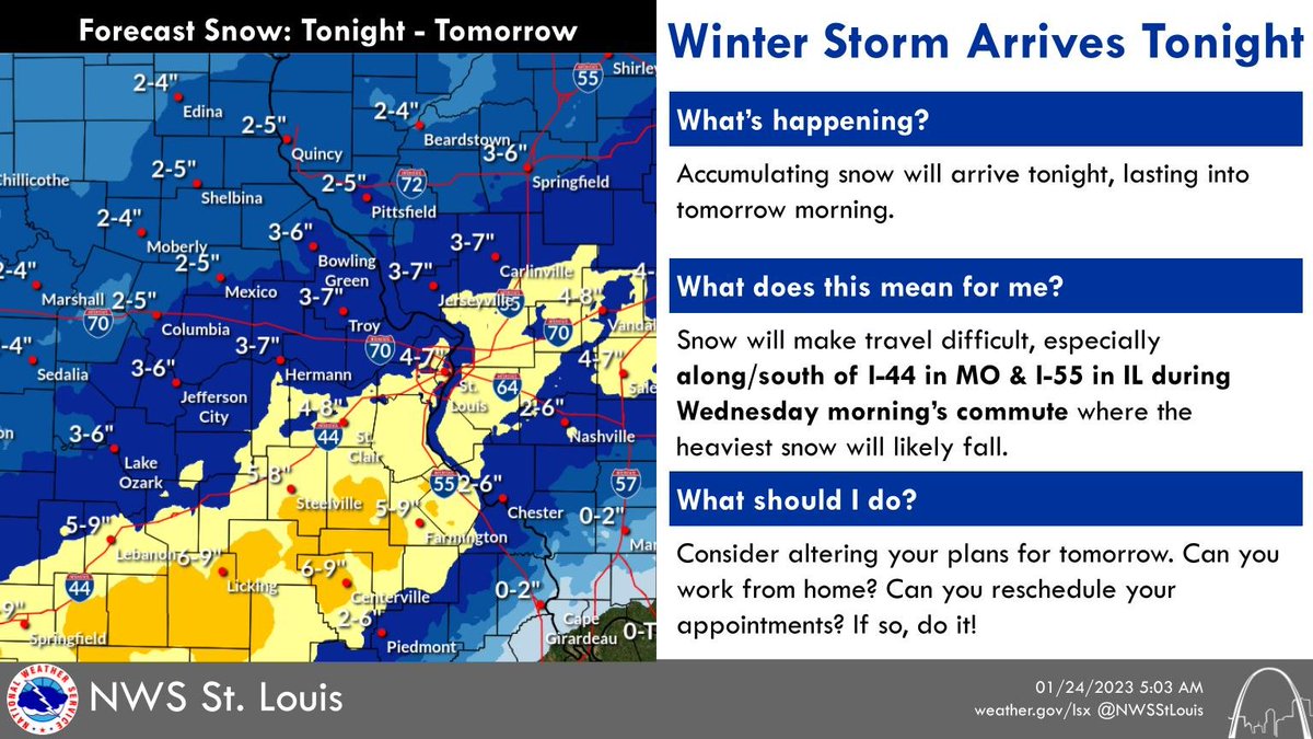
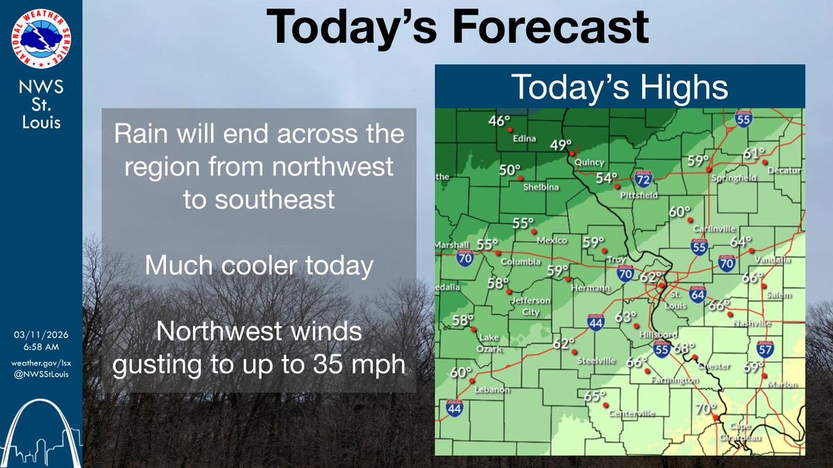
The rain will end from northwest to southeast as a cold front moves through the area. It will be much cooler today with northwest winds gusting up to 35 mph. #stlwx #midmowx #mowx #ilwx

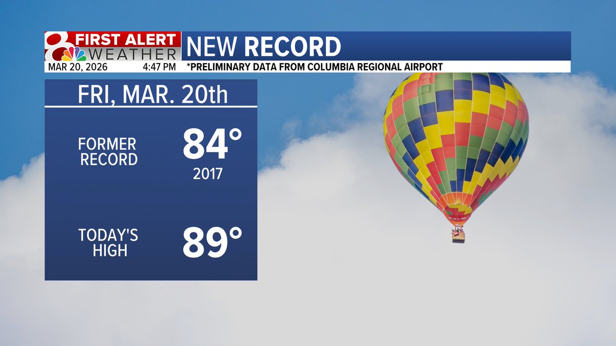
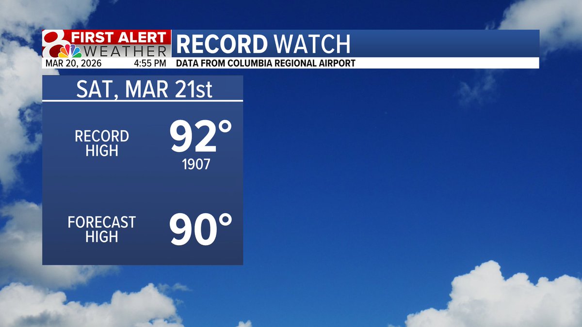
NEW RECORD! COU hit 89 degrees today breaking the previous record from 2017. There is another chance for nearing a temperature record tomorrow. #midmo #midmowx #midmo
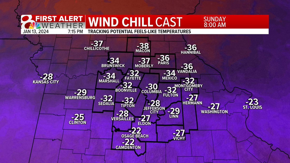
Temperatures will be dangerously cold Sunday morning. Frostbite could appear on exposed skin within minutes in these temperatures. Would not recommend taking a walk in the park 🥶 #midmowx #mowx #cold

I spent several hours this weekend sitting on a patio with friends. Today, the lock on my car door was frozen shut. #midmowx #midmo #mowx
I have said all night that our severe threat is low and that continues to decrease. Localized flash flooding continues to increase in concern as heavy rain moves over the same areas. Give yourself extra time on Thursday morning. #MidMoWx #MoWx #MidMo 1/2


Look at this awesome rainbow! I don’t think I’ve ever seen a full one before! #midmowx #nwsstlouis #nwskansascity

A couple things to keep in mind with the upcoming solar eclipse on Monday: There will be a LOT of people traveling, so stay extra aware if you're traveling anywhere on Monday. Also, don't burn your eyeballs! They'll thank you if you use official solar eclipse glasses! 🌞 #midmowx

THUNDERSTORMS: Late this week and into the weekend thunderstorm potential is expected to continue. Strong storms are possible both Thursday and Friday, but we are not yet confident enough to issue a First Alert Weather Day. #mowx #midmowx #komuwx


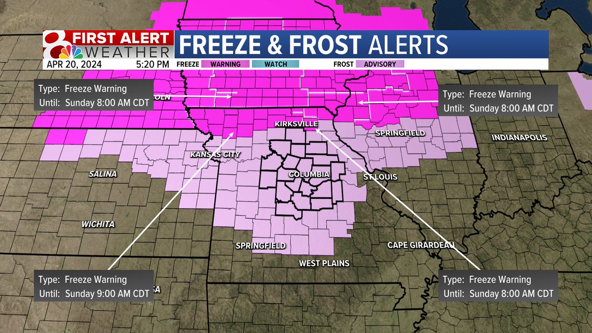
The ABC 17 Stormtrack Team will be extending our Weather Alert Day coverage through Monday morning at 10 am. Extreme cold remains with us lasting through Sunday AM, but then the possibility of freezing rain moves in Sunday night lasting through Monday morning. #midmowx

One year ago on Thursday, an EF2 tornado hit Pilot Grove, seriously damaging homes and leaving hundreds without power. KOMU 8’s Casey Bennett talked with a resident that recounts her story from that morning. #MidMoWx #MoWx #MidMo komu.com/news/midmissou…


MORE SEVERE WEATHER - There's another chance of severe weather this afternoon and evening. I'm breaking down all the details in the Futuretrack Hour-By-Hour. @ABC17News (4-3-26) #midmowx #weather #SevereWeather

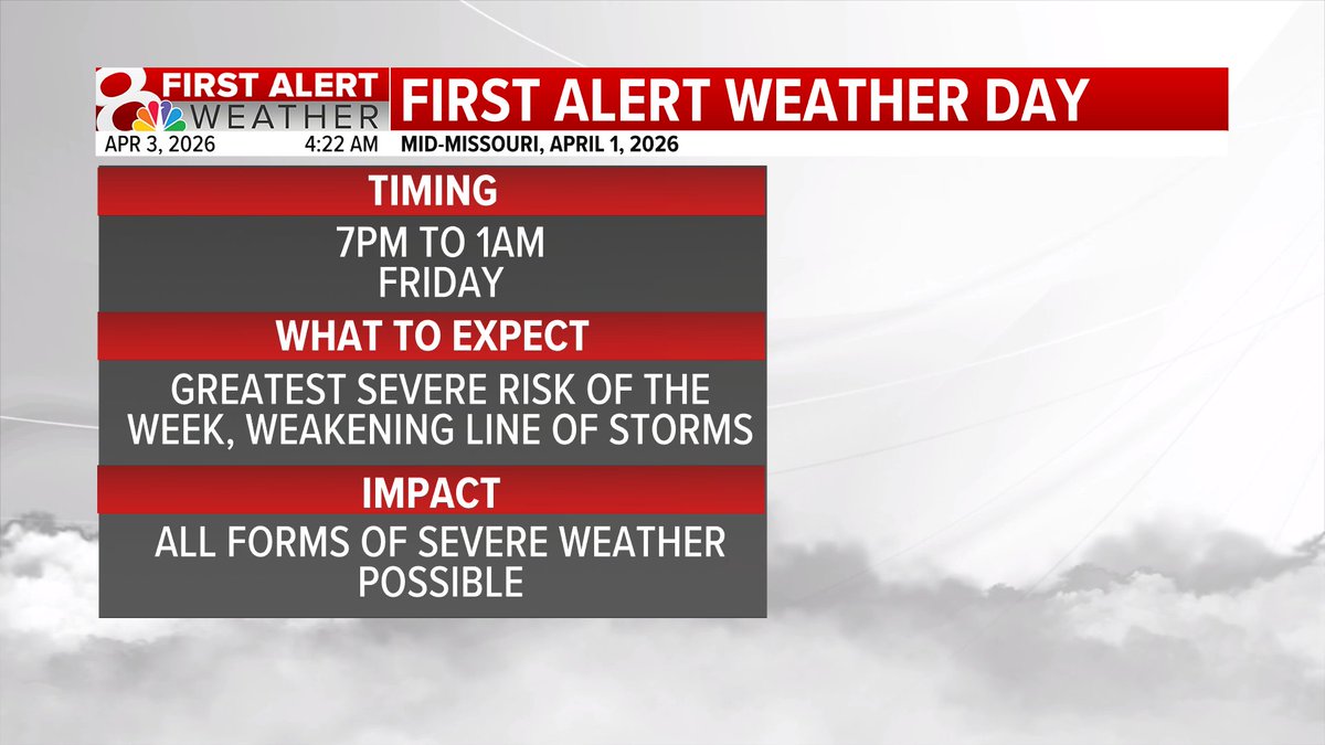
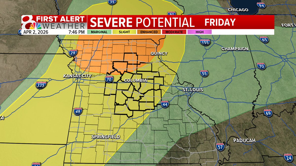
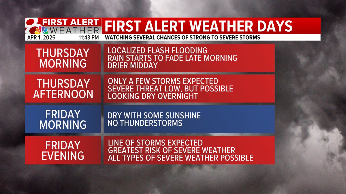
FIRST ALERT: We have our last First Alert Weather Day for the week. Timing for Friday: evening (7PM-1AM), a line of storms, more organized threat. All threats of severe weather are possible. Stay weather aware. #midmowx #midmo #mowx @KOMUnews


HEADLINES: Good morning! We are tracking more storm chances this evening and into the night. More on @KOMUnews until 7AM! #midmowx #midmo #mowx

It takes just 6" of fast flowing water to stall most cars and just 1' of water to float most vehicles away. Don't be a statistic! Don't put first responders at risk. TURN AROUND DON'T DROWN. #MidMoWx #MoWx #MidMo

"According to the daughter, they underestimated the amount of water on the road and decided to try to cross." This is how you die in a flood. I know that sounds harsh, but most flooding deaths occur in a motor vehicle. TURN AROUND DON'T DROWN #MoWx komu.com/news/father-an…

Thursday Evening Update: We'll be dry tonight & most of Friday, but our greatest chance of severe weather that we've had this week moves into the region Friday evening. All forms of severe weather possible, but damaging wind gusts will be the main concern #MidMoWx #MoWx #MidMo


Rainfall Totals (As of 5PM Thursday): Here's a look at some of the rainfall totals across the region so far this week. Most locations have seen 1-2" of rain, but there have been some big jackpots with Sedalia at 6.36" so far and Boonville at 4.34" #MidMoWx #MoWx #MidMo

A Tornado Watch has been issued for areas along and north of Highway 24 in mid-Missouri until 8PM Thursday. The main threat will be farther north into Iowa and Illinois, but those in the watch area should remain weather aware. #MoWx #MidMoWx #MidMo

Severe weather season is here! Join us for the First Alert Severe Weather Special at 6:30PM tonight (Thursday). We’ll have a look at the long range pattern, and get you prepared for the season ahead.#MidMoWx #MoWx #MidMo
Midday Thursday: A tornado watch will likely be issued in northern Missouri as well as parts of Iowa and Illinois later this afternoon. Main threat stays to the north of the KOMU 8 Viewing area. #MidMoWx #MoWx #MidMo
Friday: The greater risk of severe weather comes late afternoon and evening when a line of widespread thunderstorms is expected. The environment looks more favorable and that combination with more widespread storms means that we’ll need to watch this closely. #MidMoWx #MoWx

Thursday Midday: The main severe weather threat today is across eastern IA and into IL. Back here in mid-Mo we’ll look for isolated storms to develop with an isolated severe potential this afternoon. Most of mid-Mo won’t see severe storms, but one or two are possible. #MidMoWx

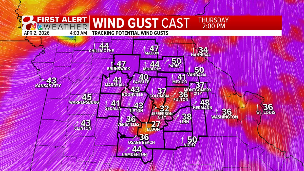
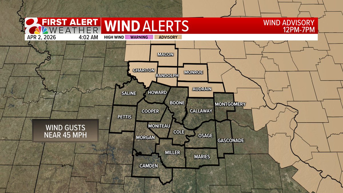
WIND ADVISORY issued for a few counties due to wind gusts up to 45 mph. Make sure the patio furniture is secure! #midmowx #midmo #mowx @KOMUnews
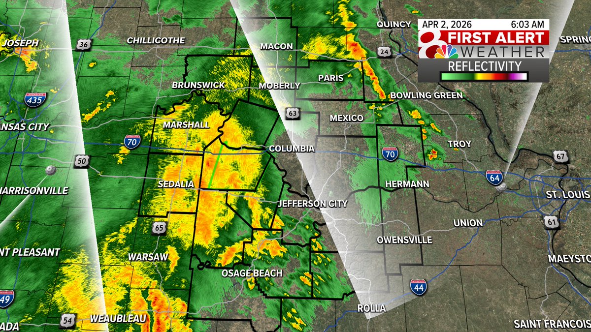
6AM RADAR UPDATE: Heavy rain now moving in to Howard County, getting ready to cross HWY 63. Grab the rain gear! #midmowx #midmo #mowx @KOMUnews
FIRST ALERT: Two First Alert Weather Days, one today and one tomorrow. Timing for Thursday: afternoon/evening, very isolated. Timing for Friday: evening, a line of storms, more organized threat. Stay weather aware. #midmowx #midmo #mowx @KOMUnews


525AM RADAR UPDATE: Heavy rain now moving into Audrain County and Monroe County. Heavy rain moving in from the southwest too. Localized flooding is a concern this morning. Add extra time to the morning commute. #midmowx @KOMUnews

5AM RADAR UPDATE: Heavy rain cross HWY 63 right now, rain continues throughout the morning commute. Grab the rain gear out the door. #midmowx #midmo #mowx @KOMUnews

Thursday midday looks dry, with isolated afternoon storms (most won’t see any, but any could be severe). Dry again Thurs night–midday Fri. Storm chances increase Friday PM, bringing greater severe risk. Both are First Alert Weather Days, but Friday is of more concern. #MidMoWx
I have said all night that our severe threat is low and that continues to decrease. Localized flash flooding continues to increase in concern as heavy rain moves over the same areas. Give yourself extra time on Thursday morning. #MidMoWx #MoWx #MidMo 1/2


Temperatures will be dangerously cold Sunday morning. Frostbite could appear on exposed skin within minutes in these temperatures. Would not recommend taking a walk in the park 🥶 #midmowx #mowx #cold
THE FIRST ALERT: A First Alert Weather Day is in place for this afternoon and this evening. Large hail, damaging wind gusts, and a spin-up tornado or two are all possible today. I'll have the latest on @KOMUNews at noon. #mowx #midmowx #komuwx


Bring the plants inside! (or give them a blanket) It's going to get cold tonight with temperatures hovering in the mid 30s causing a frost advisory to be issued for mid Missouri.🥶 #midmowx #mowx

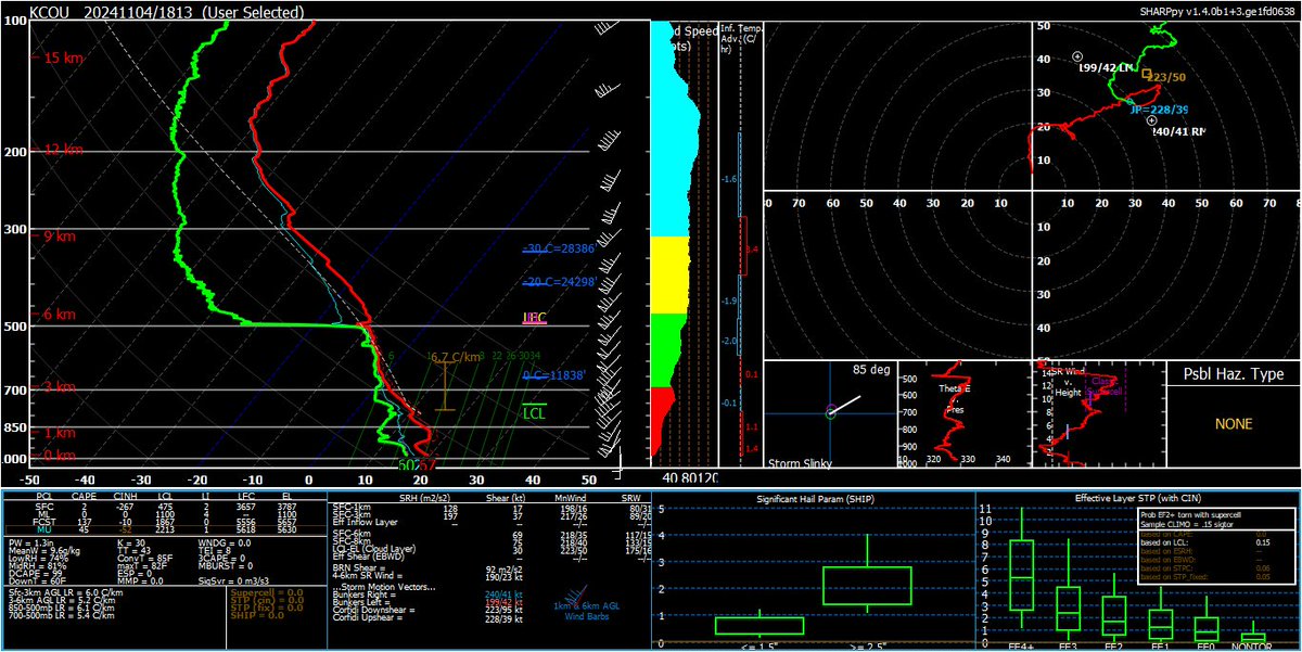
18 UTC observed sounding from Columbia, MO showed almost no instability and lackluster mid-level lapse rates well to the north of the warm front. Cleared up for about 30 minutes post-launch but is overcast again. Plenty of shear though. #mowx #midmowx #wxtwitter
Unless you're a fan of dancing in the rain, grab an umbrella! On and off showers expected throughout tomorrow! #mowx #midmowx☔️

RECORD WATCH: Highs in the middle to upper 80s will easily break the record high for today set all the way back in 1967. This record warmth won't stay for long, though. A cooler and rainy pattern begins Tuesday. #mowx #midmowx #komuwx

NICE MONDAY: Temperatures starting in the 50s and warming to the 80s make it feel more like May than March. This will be the warmest day we see for a while. #mowx #midmowx #komuwx

THUNDERSTORMS: Late this week and into the weekend thunderstorm potential is expected to continue. Strong storms are possible both Thursday and Friday, but we are not yet confident enough to issue a First Alert Weather Day. #mowx #midmowx #komuwx
ROLLER COASTER CONTINUES: Highs will warm to the lower to middle 80s to begin the work week, before a cold front passes through, bringing storm chances, and highs down to the 50s. #mowx #midmowx #komuwx

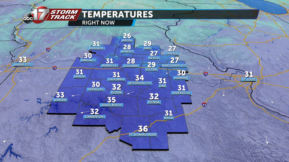
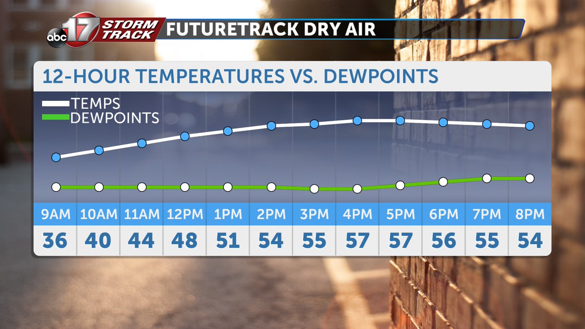
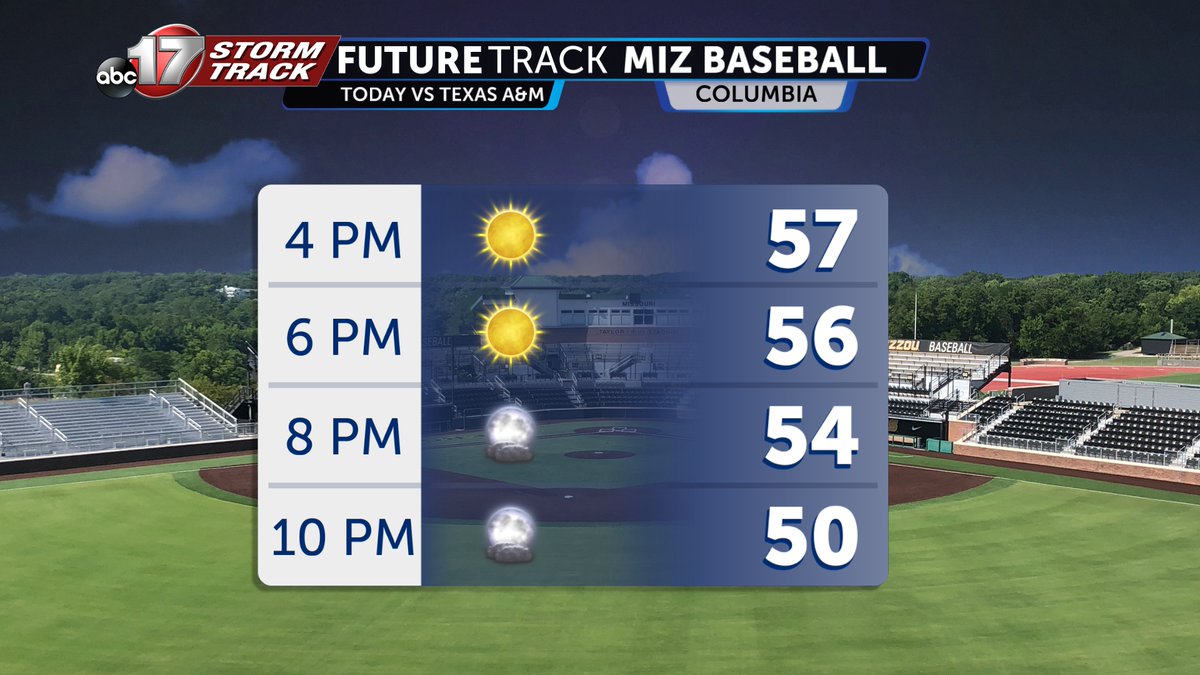
COLD START, MILD END - We are starting below freezing this morning, but mild air returns as temperatures get into the upper 50s. Conditions are favorable for rapid fire spread, so avoid burning. Looks like it will be a great evening for Mizzou Baseball! 🐯@ABC17News #midmowx

ACTIVE PATTERN AHEAD: Showers and storms will be likely Tuesday through Friday, with substantial rainfall and stronger storms being possible. We don't expect this to be anything out of the ordinary for spring, but the rain/storms could be inconvenient. #mowx #midmowx #komuwx

As expected, an observed sounding from Columbia, MO shows a strong capping inversion. Additionally, the hodograph isn't as curved as model guidance initially suggested. #mowx #midmowx #wxtwitter

TUESDAY STORMS: Our partners at the Storm Prediction Center do not currently have us in a severe weather risk for Tuesday. While a 1/5 risk for damaging wind gusts could be introduced, we don't expect any major problems. #mowx #midmowx #komuwx

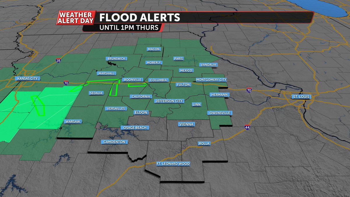
A Flood Watch is in effect for much of Mid-MO tonight as 1-3" of rain could fall over some of the same locations that saw 1-2" of rain in the last 24 hours. Low water crossings will be dangerous into the morning! #midmowx
Sunday afternoon will bring an enhanced risk of severe weather along a strong cold front to the south of I-44, with a lesser risk farther north. #stlwx #midmowx #mowx #ilwx
A couple things to keep in mind with the upcoming solar eclipse on Monday: There will be a LOT of people traveling, so stay extra aware if you're traveling anywhere on Monday. Also, don't burn your eyeballs! They'll thank you if you use official solar eclipse glasses! 🌞 #midmowx
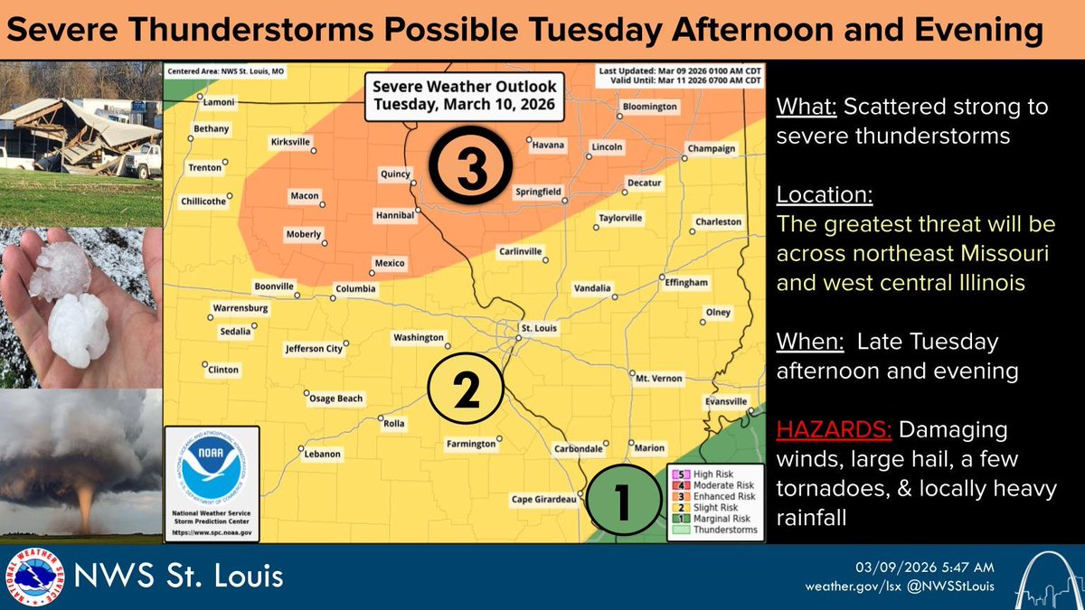
Thunderstorms are expected to develop along a front over northern Missouri and west central Illinois late Tuesday afternoon and evening. Large hail, damaging winds, and a few tornadoes will be possible with the strongest storms. #stlwx #midmowx #ilwx #mowx
We're tracking light snow this evening and overnight with a patchy dusting possible. While snow is falling, there could be lower visibility. Widespread issues are not expected. #midmowx #midmo #mowx

Something went wrong.
Something went wrong.
United States Trends
- 1. Good Friday N/A
- 2. Good Friday N/A
- 3. F-15 N/A
- 4. $ROCKET N/A
- 5. Theo N/A
- 6. Viernes Santo N/A
- 7. CSAR N/A
- 8. #FursuitFriday N/A
- 9. #LastFourWatched N/A
- 10. #FanCashDropPromotion N/A
- 11. Fraud Czar N/A
- 12. Holostars N/A
- 13. #OnlyFriendsDreamOnEP6 N/A
- 14. #FridayVibes N/A
- 15. Memphis N/A
- 16. Hassett N/A
- 17. CENTCOM N/A
- 18. Delirious N/A
- 19. IT IS FINISHED N/A
- 20. Mark Lee N/A