#rasterfunctions ผลการค้นหา

Different generalizations for different zoom levels combined with scale-dependent visibility to produce a multi-scale, multi-directional shaded relief, about to be published as a tile layer for an online map. #NasaDem processed with #RasterFunctions in #ArcGISPro. #cARTography
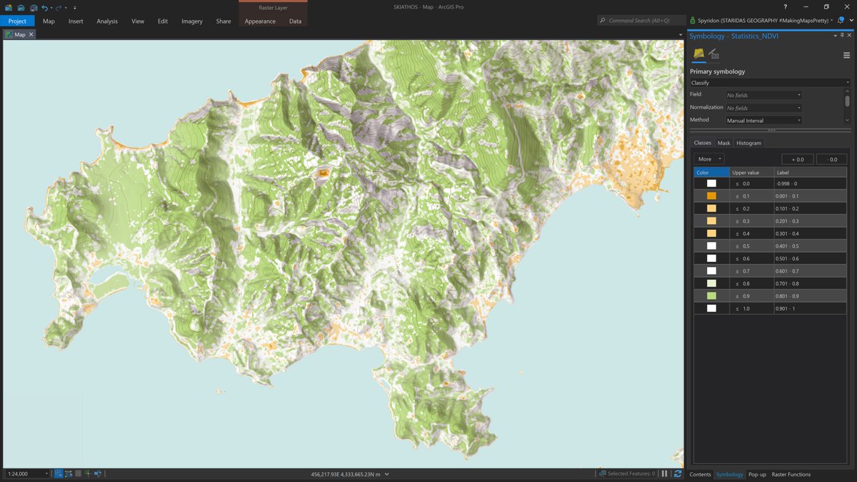
Land cover from #Sentinel2 with #RasterFunctions in #ArcGISPro completes the topo basemap. #cARTography #MakingMapsPretty
Here I apply #RasterFunctions to generalize and homogenize similar color areas in order to sample them later with the eyedropper tool. For this I split the RGB bands, perform resample and neighbor statistics, then composite back again. #cARTography #MakingMapsPretty #ArcGISPro
I wrote a blog post on how to extract the lovely colors of an old map with #RasterFunctions and the eyedropper tool in #ArcGISPro here staridasgeography.gr/lovely-colors-… #cARTography #MakingMapsPretty @ArcGISPro


another free and useful learning resource: analyzing declining malaria rates in Africa. esri.com/arcgis-blog/pr… #rasterfunctions

#EsriUC 5 R&D focuses lately re: #remotesensing 1.bring in any dataset 2. Better image mgmt including indexed spatiotemporal cubes 3. Better map production with imagery 4. Better analysis capabilities (learn about #rasterfunctions if you havent) 5. Better search, discovery, & viz
I wrote a blog post on how to extract the lovely colors of an old map with #RasterFunctions and the eyedropper tool in #ArcGISPro here staridasgeography.gr/lovely-colors-… #cARTography #MakingMapsPretty @ArcGISPro
Here I apply #RasterFunctions to generalize and homogenize similar color areas in order to sample them later with the eyedropper tool. For this I split the RGB bands, perform resample and neighbor statistics, then composite back again. #cARTography #MakingMapsPretty #ArcGISPro
Different generalizations for different zoom levels combined with scale-dependent visibility to produce a multi-scale, multi-directional shaded relief, about to be published as a tile layer for an online map. #NasaDem processed with #RasterFunctions in #ArcGISPro. #cARTography
Land cover from #Sentinel2 with #RasterFunctions in #ArcGISPro completes the topo basemap. #cARTography #MakingMapsPretty
#EsriUC 5 R&D focuses lately re: #remotesensing 1.bring in any dataset 2. Better image mgmt including indexed spatiotemporal cubes 3. Better map production with imagery 4. Better analysis capabilities (learn about #rasterfunctions if you havent) 5. Better search, discovery, & viz
another free and useful learning resource: analyzing declining malaria rates in Africa. esri.com/arcgis-blog/pr… #rasterfunctions
Land cover from #Sentinel2 with #RasterFunctions in #ArcGISPro completes the topo basemap. #cARTography #MakingMapsPretty
Something went wrong.
Something went wrong.
United States Trends
- 1. #Talus_Labs N/A
- 2. Lakers 76.8K posts
- 3. Luka 69.4K posts
- 4. Wemby 26.6K posts
- 5. Marcus Smart 6,029 posts
- 6. #LakeShow 5,678 posts
- 7. Russ 10.9K posts
- 8. Blazers 8,674 posts
- 9. #AmphoreusStamp 6,927 posts
- 10. Ayton 16.2K posts
- 11. Horford 2,002 posts
- 12. Will Richard 6,563 posts
- 13. #RipCity N/A
- 14. #dispatch 64.3K posts
- 15. Godzilla 1,098 posts
- 16. Kuminga 3,362 posts
- 17. Nico Harrison 1,869 posts
- 18. Unplanned 5,608 posts
- 19. Podz 2,427 posts
- 20. Klay 8,413 posts