
ECCC Weather Yukon
@ECCCWeatherYT
Canada’s official weather and climate source. Tweets by @environmentca meteorologists. Suivez-nous en français @ECCCMeteoYT Terms: http://ow.ly/yBnM30le8Za
You might like


Looking for 24/7 #Weather alerts from Environment Canada on Twitter? Find an account to follow here: ec.gc.ca/meteo-weather/…
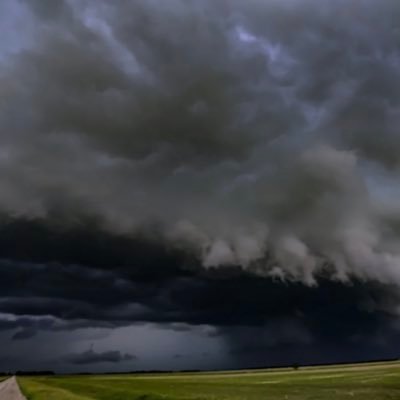
🚨Satellite imagery shows a powerful pacific storm sending heavy snow & strong winds into White Pass & Chilkat Pass! Winter Storm Warnings are in effect: up to 50 cm snow & low visibility in blowing snow possible now through Friday. ow.ly/PMUA50XkCU6 #YTStorm
Halfway through October 2025, most areas have seen less than 10 mm so far — but Dawson’s sure soaking it up, already at its monthly average! ☔ #YTStorm


When severe weather is on its way, we issue Warnings, Advisories, and Watches - so you can take action to protect yourself, those around you, and your property. Learn more about weather alerts: ow.ly/uxz450WX6xQ #WeatherReady
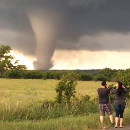
⛈️ Severe Thunderstorm Watches are in effect over southeastern Yukon (July 31, 2025). Plenty of energy & instability in the atmosphere = potential for strong wind gusts, large hail & heavy rain. 🔗ow.ly/FppP50WyhqX 🌩️#whenthunderroarsgoindoors #YTStorm

Heads up! Severe Thunderstorm Watches are in effect for Mayo & Watson Lake ⛈️ (July 29, 2025) Conditions are lining up for storms that could bring: 💨 strong winds 🌧️ heavy downpours 🌨️ large hail 🔗 ow.ly/Zixr50WwW4c #whenthunderroarsgoindoors #YTStorm

A blast of wintry weather impacts the northern Yukon Tuesday & Wednesday! ❄️ 👀 ow.ly/GrmH50Wm2tO
Dig out your parkas...our weather whiplash continues this week for Yukon. After record breaking mild temperatures in the single digits yesterday, temps will drop to the –40s in central Yukon and the –30s further south by the weekend #YTStorm ow.ly/S4jz50UOXeq


Record-breaking temperatures continued yesterday as daily highs approached the mid-single digits. The warm weather sticks around today but a change is on the way with –20°C temperatures expected late this week #ytstorm Summary: ow.ly/2Gvy50UGnqX


The first week of January will be a cold one for Yukon. Watch for temperatures in the minus 20s by tomorrow afternoon in the south, closer to –30 further north. Cold weather and wind chills in the –40s expected by the weekend. #ykstorm #cold
Parts of southern Yukon could get their coveted “Perfect Christmas” this year with snow expected on Wednesday. Above seasonal temperatures are expected through the holidays this year in the territory so plenty of time to get outside #YKWx #HappyHolidays
This fall has a bit of a split in Yukon, with slightly cooler temperatures to the south, but warmer in the far north. It was also on the drier side in most areas with Old Crow and Burwash seeing their top 10 driest falls on record. #ykstorm 🍂


A winter storm warning is now in effect for southern Yukon with 20-30 cm expected. ❄️ begins tomorrow morning lasting through Wednesday afternoon. #YTStorm #shiftintowinter @511yukon Alerts: ow.ly/zPIG50TUZCZ

Out with the old, in with the new! Our #WeatherCAN app has a new look. It will now be a breeze to get your #weather information, directly to your mobile device! Check it out today: ow.ly/Uc9c50TS1q1
Yukon’s first substantial snow is on the way to close the work week. Steady snow will begin in the far south on Thursday and continue through Saturday in the southeast. Expecting a widespread 5-10 cm for the south with up to 20 cm towards Swift River and Watson Lake #YKStorm
Temps will take a nosedive this week. Watch for overnight lows to fall towards –10°C by Thursday night and the low minus teens by the weekend in south and central Yukon (around 15°C below normal). Local wind chill values in the minus 20s expected on Friday morning. ️#YKstorm
Winds will pick up tonight and remain strong through tomorrow/tomorrow night in the north. Gusts to 60 km/h for most areas & up to 80 km/h along the Dempster Hwy. Blowing snow expected in the north, so take care on the roads and tie down loose items #YKstorm
Wintry mix is likely to arrive to northern Yukon tonight to tomorrow afternoon. (Red: Freezing Rain, Blue: Snow, Green: Rain) #YTstorm ow.ly/kByF50Taiee


United States Trends
- 1. Cheney 39.3K posts
- 2. Election Day 83.7K posts
- 3. Logan Wilson 3,831 posts
- 4. Good Tuesday 28.9K posts
- 5. GO VOTE 72.9K posts
- 6. #tuesdayvibe 1,586 posts
- 7. Rolex 16.1K posts
- 8. Jerry 45.2K posts
- 9. Halliburton 2,114 posts
- 10. #Talus_Labs N/A
- 11. #Election2025 2,261 posts
- 12. George W. Bush 8,943 posts
- 13. #TuesdayFeeling 1,038 posts
- 14. Jonathan Bailey 49.8K posts
- 15. St. Charles Borromeo N/A
- 16. Hogg 8,325 posts
- 17. iPads N/A
- 18. Congratulations Laura N/A
- 19. WMDs 1,267 posts
- 20. Kissinger N/A
You might like
-
 ECCC Weather Northwest Territories
@ECCCWeatherNT -
 ECCC Weather Nunavut
@ECCCWeatherNU -
 ECCC Weather Prince Edward Island
@ECCCWeatherPE -
 ECCC Weather Nova Scotia
@ECCCWeatherNS -
 ECCC Weather Saskatchewan
@ECCCWeatherSK -
 ECCC Weather Newfoundland and Labrador
@ECCCWeatherNL -
 ECCC Weather Alberta
@ECCCWeatherAB -
 ECCC Weather New Brunswick
@ECCCWeatherNB -
 ECCC Weather Quebec
@ECCCWeatherQC -
 ECCC Weather Manitoba
@ECCCWeatherMB -
 ECCC Météo Québec
@ECCCMeteoQC -
 ECCC Météo Ontario
@ECCCMeteoON -
 ECCC Météo Manitoba
@ECCCMeteoMB -
 ECCC Météo Yukon
@ECCCMeteoYT -
 ECCC Weather Ontario
@ECCCWeatherON
Something went wrong.
Something went wrong.