
내가 좋아할 만한 콘텐츠


#SeaIce coverage along the northern route of the #NorthwestPassage reached a record low for mid-October, creating an open water route along the waterway—an unprecedented event for this late in the season. #Arctic #ClimateChange

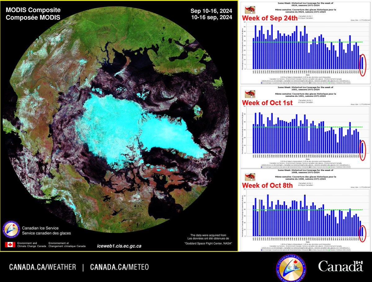
The Canadian #Arctic #seaice minimum was reached on Sept 10, 2024, with a coverage of 12% (336,446 km²), a close 2nd to the record low of 11% set in 2012. However, ice coverage over the past 3 weeks has set new record lows for this time of year, based on records since 1971.
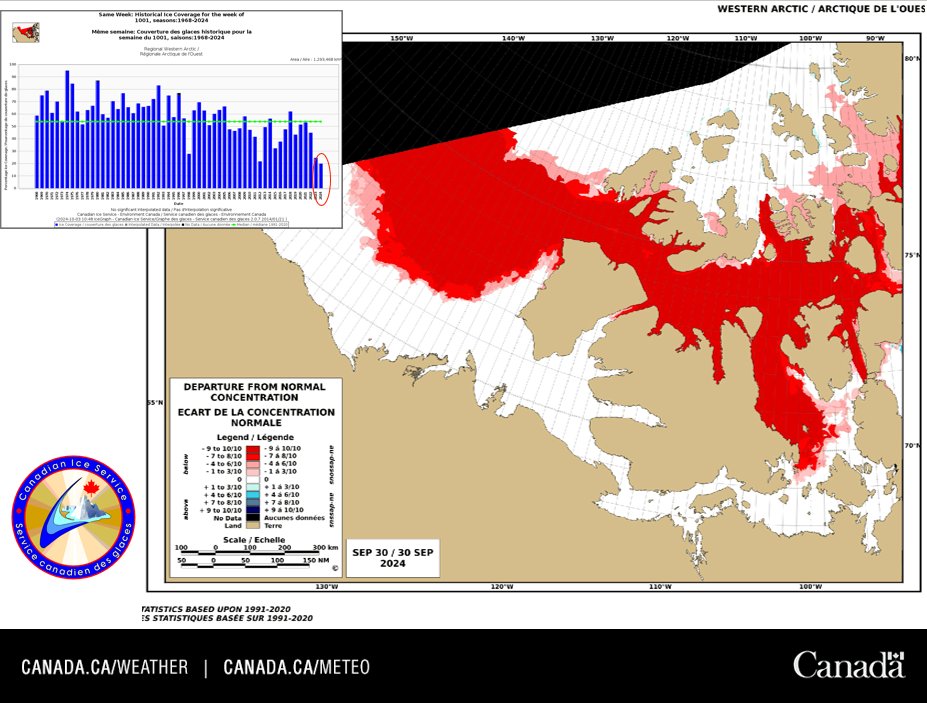
Over the past three weeks, the western #Arctic has seen the lowest #seaice coverage for this time of year since observations began in 1968. The red areas on this map highlight regions with little to no ice compared to the climatological record. #climate #northwestpassage
High resolution Sentinel-2 #satellite image from March 21st showing the recent break-up of #seaice along the Yukon coast due to strong southeasterly winds and mild temperatures. @ECCCWeatherYT @ECCCWeatherNT #Arctic #climate

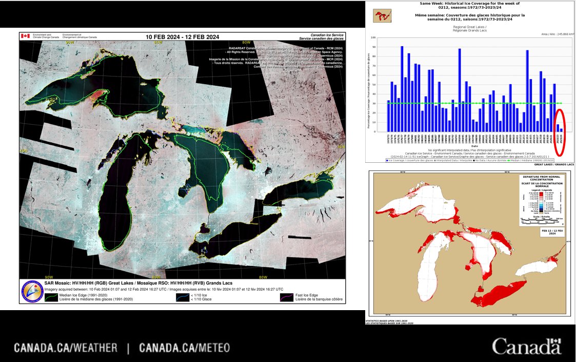
The past week had record breaking low ice coverage in the #GreatLakes. The 3% coverage is the lowest on record for the week of February 12th since 1973. #lakeice #climate @CoastGuardCAN
So far this winter, the #GreatLakes and the #eastcoast waters have had the 2nd lowest total accumulated ice coverage on record, at 1.2% and 0.5% respectively. The lowest was 0.6% in 2006/2007 for the Great Lakes and 0.2% in 2010/2011 for the east coast.#seaice #lakeice #climate
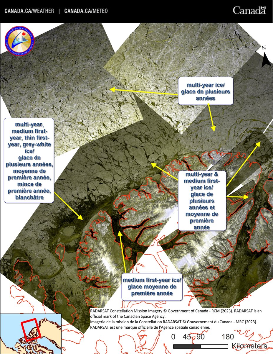
Tuvaijuittuq means "the place where ice never melts" in #Inuktitut. Recent RCM #satellite images show some of the oldest and thickest #seaice in the #Arctic Ocean in this culturally, historically and ecologically significant marine protected area. @environmentca @FishOceansCAN
#Sentinel1 #satellite animation along the NWT coast on December 5, 2023, showing how persistent southeasterly winds can cause thicker mobile #seaice to move offshore, leading to thinner ice formation adjacent to the landfast ice. #climate #Arctic
#Seaice freeze-up is around 1-2 weeks slower than normal over northern Hudson Bay, southern Foxe Basin and western Davis Strait due to anomalously high temperatures in many regions in the Canadian #Arctic throughout November. #climate @CoastGuardCAN

What a difference 19 years can make! Not only have our ice charts changed, but so has the western #Arctic ice regime! This past week's western Arctic #seaice coverage is the lowest ever recorded for this time of year. At 55% coverage, it is well below the #climate median of 89%.
Bellot Strait is notorious for being a critical point along the northwest passage since it is narrow and can fill rapidly with #seaice due to the up to 8 knot ocean current. #Arctic #shipping @CoastGuardCAN
This year (2023), the northern route of the #NorthwestPassage had a minimum #seaice coverage of 6% during the week of August 27. This coverage is the 2nd lowest on record since 1968; the lowest was 4% and occurred in 2011. #Arctic @CoastGuardCAN #climate

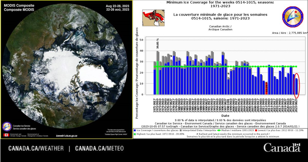
The 2023 Canadian #Arctic #seaice minimum occurred around August 28th. The 14.83% total ice coverage was the 4th lowest since 1971. The record for the lowest ice minimum was in 2012, with a total ice coverage of 11.29%. #climate @eccc_news
This MODIS #satellite animation from March 20th to April 2nd, 2023, shows the recent formation of the Nares Strait #icebridge. #shipping #climate #seaice #Arctic @CoastGuardCAN
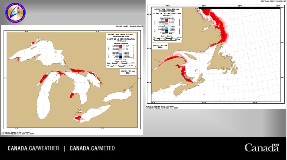
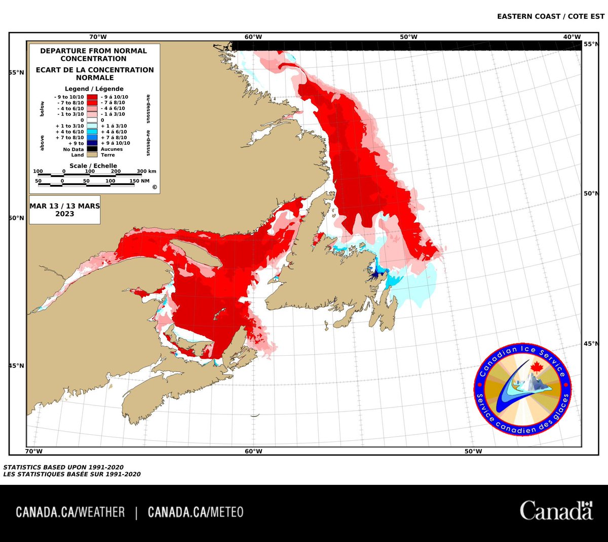
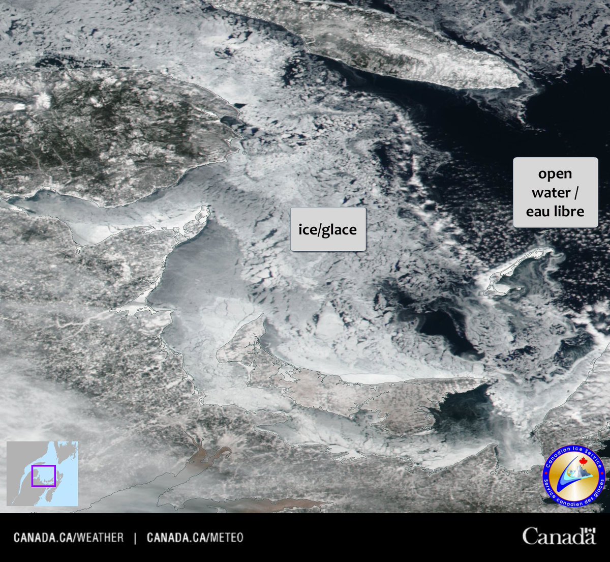
The most recent "Departure from Normal Concentration" chart for the East Coast region shows a #seaice coverage far below normal.
Animation of MODIS #satellite imagery showing an unusually large area of fast #seaice in the Beaufort Sea. In the final 2 frames, the ice suddenly breaks away from the coast, re-establishing a more typical fast ice extent. #Arctic #climate
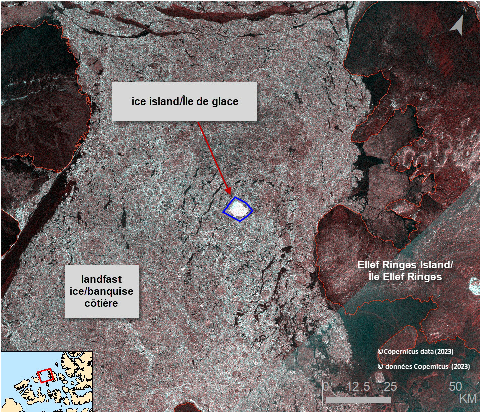
Sentinel #satellite image from March 8th showing a 28 km2 #iceisland (fragment of the #MilneIceShelf) embedded in the land fast old #seaice, ~26 km west of Ellef Ringnes Island. #Arctic #shipping #climate #iceberg

Sea ice in the Gulf of St. Lawrence was relatively late forming this winter, but satellite imagery recorded an increase during the month of February, as shown in this image of ice conditions around the Iles-de-la-Madeleine, Quebec. Radar satellites effectively monitor icy waters.
Recent cold temperatures have caused significant ice growth across much of the western Gulf of St. Lawrence region, as seen in this visual #satellite image from the end of February. #MODIS #seaice #icebreaking
Ice cover is usually close to its peak at this time of year on the #GreatLakes. This year has hit a new record low at just 8% coverage, well below last year’s 51% and the historical median of 30%. #lakeice #climate @ECCCWeatherON


United States 트렌드
- 1. Skattebo 15.5K posts
- 2. Saquon 11.8K posts
- 3. Nick Mangold 22.8K posts
- 4. #NYGiants 2,741 posts
- 5. Vini 107K posts
- 6. #FlyEaglesFly 5,581 posts
- 7. James Cook 2,377 posts
- 8. Tush Push 9,506 posts
- 9. Lamine 254K posts
- 10. Ravens 32.4K posts
- 11. #ElClasico 93K posts
- 12. Go Birds 8,233 posts
- 13. Myles Garrett 1,375 posts
- 14. Madrid 539K posts
- 15. Mike Green 1,313 posts
- 16. Andy Dalton 2,785 posts
- 17. #BillsMafia 5,521 posts
- 18. #NYGvsPHI N/A
- 19. Tyler Nubin N/A
- 20. Barca 178K posts
내가 좋아할 만한 콘텐츠
-
 ECCC Weather Northwest Territories
@ECCCWeatherNT -
 ECCC Weather Yukon
@ECCCWeatherYT -
 ECCC Weather Nunavut
@ECCCWeatherNU -
 Canada Gazette
@CanadaGazette -
 ECCC Canadian Hurricane Centre
@ECCC_CHC -
 ECCC Weather Quebec
@ECCCWeatherQC -
 Canadian Anti-Fraud Centre
@canantifraud -
 CMOS-SCMO
@CMOS_SCMO -
 Dr. Merritt Turetsky
@queenofpeat -
 BC Sport Fish (DFO)
@sportfishingbc -
 TIPS_SPIIE
@TIPS_SPIIE -
 OMEAOntario
@OMEAOntario -
 PolarKnowledgeCanada
@POLARCanada -
 Kimberly Murray
@kahnasatake -
 Patrick Duplessis
@Pat_wx
Something went wrong.
Something went wrong.