EOdatascience
@EOdatascience
At EO Data Science, our mandate is to harness the power of what we can see, learn and know from space to help organisations enact positive change.
You might like


🌍 Did you miss this NGIS and SADA webinar? ESG compliance and sustainability initiatives are growing importance in today's business world! 🔗 Register to watch now: bit.ly/3NyCRTd
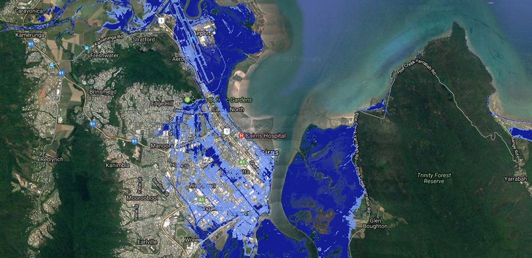
🌊With rising sea levels posing a threat to valuable infrastructure and private property, our mapping technology provides an intuitive interface for interpreting crucial information and making data-driven decisions. See if your house is safe: bit.ly/434Jcf6
Customers are tired of false sustainable claims and are demanding more clarity. The ACCC has noticed and is cracking down on businesses! Learn how your company verify products sustainability impact and avoid greenwashing. 🌱 bit.ly/42XzEDA
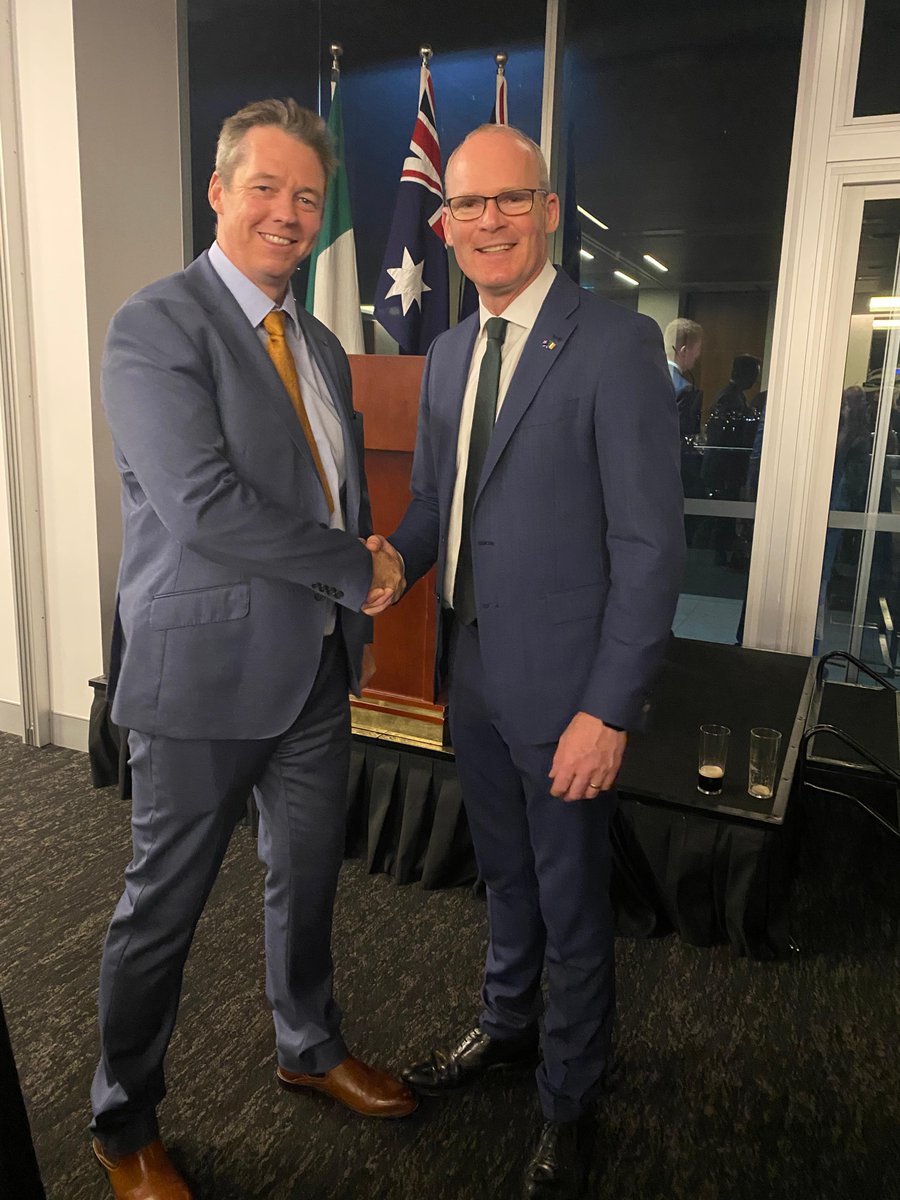
Rory Donnelly attended a celebration of St Patrick's Day with Ireland's Minister of Enterprise, Trade and Employment, Simon Coveney. The event celebrated the partnership between the two countries. 🇮🇪🇦🇺
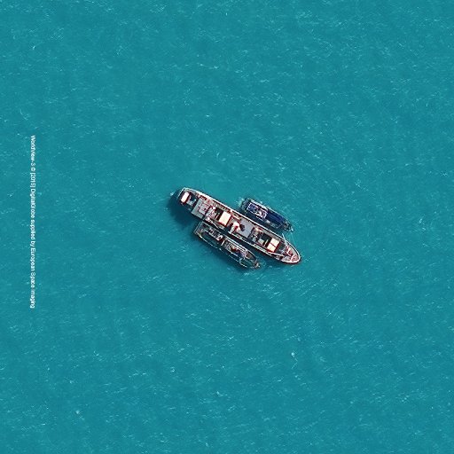
The international surface water and ocean topography (SWOT) satellite recently took off from Vandenberg in California. 🚀The UK-backed mission will observe huge swathes of the ocean and surface water in unprecedented detail. Read more here: bit.ly/3Iz3wyd
A new #EarthEngine tutorial just went live 🌏 The tutorial is learning about how to work with gap-filled imagery- HISTARFM. Read more here: bit.ly/3AT2sAO
developers.google.com
HISTARFM - How to Work with Gap-Filled Imagery | Google Earth Engine | Google for Developers
HISTARFM - How to Work with Gap-Filled Imagery | Google Earth Engine | Google for Developers
Google Earth Engine can be used to monitor land use and land cover for agriculture but can it predict a feast or famine? Read more here: bit.ly/3UTcDxf
At @COP27, we’re talking about how geospatial data can make supply chains more sustainable. Learn how #GoogleCloud and @ngis_australia TraceMark platform shows the impact of sourcing a particular material on the environment in our Live from COP27 report. google.smh.re/1sLZ

The European Parliament have passed a law to ban imports of raw materials that have been linked to deforestation! 🌲The legislation includes commodities such as cattle, cocoa, coffee, palm oil, soy, and wood. Read more here: bit.ly/3VatPhi
Clean energy is looking towards geospatial technology to mitigate environmental risks. The solar industry is continuing to expand and this comes a heightened need to identify where panels, solar farms and infrastructure should be located. Read here: bit.ly/3t5PpaU
Geo for Good Summit has announced this open access book "Cloud-Based Remote Sensing with Google Earth Engine." 📖 The book caters for all levels- beginners to experts. Read the book here: bit.ly/3EuaFOs
Interested in #deeplearning and how we can normalise it to improve models? Read more to see how different factors influence the data and how to normalise it: bit.ly/3LZpk5M
The Queensland Earth Observation Hub launches with two new #earthobservation projects. 🛰️The new projects will monitor remote geohazards such as flood water levels or landslides and Queensland's coasts for hazards and conditions. Read more: bit.ly/3USbN40
We are a 100% carbon neutral business! At EO we care about the impact we have in the world, particularly the emissions we make through a business. We are making more conscious decisions about the way we do business! Find out more about us here: bit.ly/3BNzpyf
Australia's space sector has plans to grow to $12 billion and add 20,000 jobs by 2030 🚀 This growth has great opportunities for those industries ready to use space-enabled technology for data-driven insights. Read more: bit.ly/3f3zlCt #geospatial #GEE
Round 12 of the lightning talk from Group on Earth Observations @googleearth Program is up. In the talk, you'll hear from five project teams on how they used Google Earth Engine on People & Society. Watch here: bit.ly/3R1X3gz
youtube.com
YouTube
Geo for Good Lightning Talks #12: GEO-GEE Programme - People & Society
The OFE platform leverages #geospatial technology to effectively analyse field trials. Read more here: bit.ly/3bZKAe9
NGIS has been part of a three year research collaboration to help grain farmers be their own in field scientists. More than 35 farmers participated in the @foodagility project, running 50 experiments testing the application of fertilisers and the impact on yield.
With CI facing constant threats, both natural and manmade, #geospatial data is essential for the in-depth risk analysis required to inform policy and make decisions. Excitingly, the #GEE Community Dataset now includes the CISI! Share the GitHub project: bit.ly/3zPR5cz
Critical Infrastructure (CI) is the foundations of a society and a requirement for socio-economic development. Sadhana Nirandjan outlines the a Critical Infrastructure Spatial Index (CISI) in her paper: go.nature.com/3Qa4ZM3


United States Trends
- 1. #HardRockBet 3,984 posts
- 2. Arsenal 284K posts
- 3. Tottenham 91K posts
- 4. Mason Rudolph 3,311 posts
- 5. Thomas Frank 7,052 posts
- 6. #ARSTOT 16.3K posts
- 7. Nahshon Wright N/A
- 8. #HereWeGo 2,306 posts
- 9. #COYG 7,229 posts
- 10. #AskFFT 1,190 posts
- 11. Go Birds 8,043 posts
- 12. Richarlison 10.2K posts
- 13. Merino 20.6K posts
- 14. Klay 43.8K posts
- 15. Raya 17.6K posts
- 16. Trossard 17.5K posts
- 17. Great for 60 1,009 posts
- 18. Eberechi Eze 11.3K posts
- 19. Sean Tucker 1,104 posts
- 20. Cornbread 2,287 posts
You might like
-
 Earth Blox
@EarthBlox -
 Justin Braaten
@jstnbraaten -
 Remote Sensing MDPI
@RemoteSens_MDPI -
 Group on Earth Observations
@GEOSEC2025 -
 GEDI
GEDI
@GEDI_Knights -
 IEEE Geoscience and Remote Sensing Society
@IEEE_GRSS -
 Radiant Earth
@OurRadiantEarth -
 ForestSAT
@ForestSAT -
 SERVIR Global Collaborative
@SERVIRGlobal -
 Laura Duncanson
@lauraduncanson -
 Africa Flores
@africa_science -
 GRSS IADF
@GrssIadf -
 SPACE4GEO Alliance
@SPACE4GEO -
 Belgian Earth Observation
@BelgianEO
Something went wrong.
Something went wrong.