
Masae Analytics
@MasaeAnalytics
Data Science for Informed Decisions
You might like


The sulfur dioxide plume from the recent Hayli Gubbi eruption in Ethiopia was detected by ESA’s Sentinel-5P satellite as it crossed southern Arabia and reached Kathmandu today. The animation shows high SO2 concentrations linked to the eruption, extending over 10,000 km.

🛰️ Welcome @MasaeAnalytics to the EARSC community! Masae harnesses EO data & data science to drive social & economic development in emerging countries, turning complex data into valuable insights & impact. Learn more (masae-analytics.com)


The construction of the Qosh Tepa canal in Northern Afghanistan is progressing rapidly, evident even from space through the analysis of Sentinel-2 data (NDWI index here: sentinelshare.page.link/sKTT)

Spectacular satellite image of the fuel depot fire in Conakry available with Sentinel 3 (ESA) - dated Dec 18th


Une carte des destructions dans la bande de Gaza a été produite par Masae Analytics, une entreprise spécialisée dans l'analyse de l'imagerie satellite. Cette imagerie permet de déceler les bâtiments détruits ou endommagés par les frappes israéliennes liberation.fr/international/…
liberation.fr
Guerre Hamas-Israël : la carte des destructions dans la bande de Gaza depuis le 7 octobre
La comparaison de deux séries d’images radar de l’enclave palestinienne, prises à cinq semaines d’intervalle, permet de déceler les bâtiments détruits ou endommagés par les frappes israéliennes.

Quelle: Sorgfältige Satellitenbildanalyse von @MasaeAnalytics und weitere Recherche @adinarenner und @jesseberhart (und nicht die Hamas).

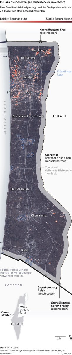
Auf diese Gebiete im Gazastreifen richtet Israel seine Luftangriffe – @jesseberhart und ich zeigen auf Karten und mit Satellitenbildern, welche Stadteile am stärksten betroffen sind. 👉nzz.ch/international/… 🛰️ Analyse von @MasaeAnalytics
Uncovering the destruction of Gaza reuters.com/graphics/ISRAE… with @JonRMcClure @Da_Pacific and @AditiHBhandari

How to Leverage Satellite Data in Journalism ? The next two dates for our 8-hour training sessions, designed specifically for journalists, are Sept 20th in Paris and Oct 12th in London (limited availability of only 15 spots per session). Register here masae-analytics.com/trainings

Mapping Ukraine’s counteroffensive. Today we Uncover the extensive destruction of Bakhmut in a new detailed analysis reuters.com/graphics/UKRAI… with @JonRMcClure Thanks @MasaeAnalytics for the analysis
New analysis by Masae Analytics, a technology & strategy consulting firm, using satellite images and algorithm-based analysis, has measured the severity of the destruction in Bakhmut

... once this important step is over, you can just follow what these leaks become over time using RGB images from Sentinel-2 or Landsat 8/9. Sentinel-2 flew over the area on Friday, and by chance the sky was a lot clearer. Water was still bubbling...apps.sentinel-hub.com/eo-browser/?zo…
apps.sentinel-hub.com
Sentinel-hub EO-Browser3
Sentinel-2 L2A imagery taken on September 30, 2022
It was way easier to confirm Nord Stream leaks location using Sentinel-1 SAR imagery from the 29th of September than trying to find large white bubble blobs in an area mostly covered by clouds ! apps.sentinel-hub.com/eo-browser/?zo…

Our latest analysis using Sentinel-1 SAR data over Ukraine has been used to build very effective data visualisations by (to name a few) El País (english.elpais.com/international/…), Der Spiegel (spiegel.de/international/…), La Vanguardia and Die Zeit (zeit.de/politik/auslan…)
zeit.de
Krieg in der Ukraine: Die Schlacht um Mariupol
Mariupol ist einer der schlimmsten Schauplätze des russischen Angriffskrieges. Eine Dokumentation der Belagerung in Chatverläufen, Satellitenbildern, Karten und Videos
Don't miss out on this great opportunity at Masae!

🆕 Nouveau job publié : Développeur FullStack - Conseil en Data Science dans les pays émergents - CDI 🏬 Masae Analytics 🌎 11 Rue de Milan, 75009 Paris, France #ESS #emploi #socent #job 👉bit.ly/3vfQT47


United States Trends
- 1. Dodgers N/A
- 2. Good Friday N/A
- 3. #FanCashDropPromotion N/A
- 4. #FridayFeeling N/A
- 5. Guehi N/A
- 6. #RetoAdmirable2026 N/A
- 7. Nobel N/A
- 8. Smart Money N/A
- 9. AI Summary N/A
- 10. Happy Friyay N/A
- 11. RED Friday N/A
- 12. Mets N/A
- 13. #PowerBookForce N/A
- 14. #FridayMotivation N/A
- 15. Yankees N/A
- 16. Stearns N/A
- 17. Tariq N/A
- 18. Diaz N/A
- 19. Finally Friday N/A
- 20. Kyle Tucker N/A
You might like
-
 NorwayNATO
@NorwayNATO -
 ALIPH Foundation
@ALIPHFoundation -
 Verena Hölzl
@verenahoelzl -
 Tom Patterson
@MtnMapper -
 Isabelle Steyer
@isabelle_steyer -
 Romain Laveau 🇪🇺🌻
@RomainLaveau -
 Ridhwaan Suliman
@rid1tweets -
 CardMedic
@cardmedic -
 Olivier Sarbil
@oliviersarbil -
 SOCOMJOHN
@SOCOMJOHN -
 boaz (Malik)🗳⭐️⭐️(6624)
@boaz1999 -
 S
S
@shaykzer -
 ZeroRelevance
@ZeroRelevance0 -
 Andrea Ruggeri
@AndreaRuggeri71 -
 沙米 ⏚ 🇵🇸🇳🇨
@80ZavjWkDwV3CdD
Something went wrong.
Something went wrong.