
你可能會喜歡


A nationwide survey of damage to buildings in Ukraine is a big part of my dissertation research. @JamonVDH and I worked with the talented @TmarcoH and @wallacetim to support their team @nytimes reporting on damage with our data. Their piece is out today: nytimes.com/interactive/20…

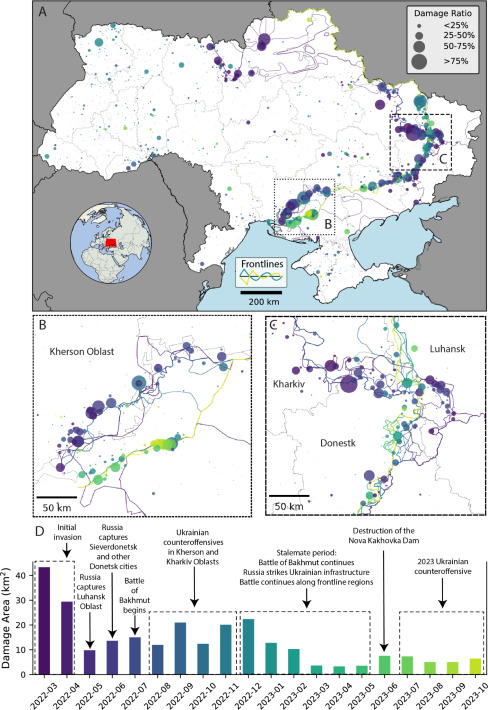
With new approaches to urban damage mapping in #Ukraine using #InSar we can make quick analysis of risk to hazardous facilities, and building debris etc estimates to assess public health and environmental harm. Great paper by @coreymaps / @JamonVDH sciencedirect.com/science/articl…

Honoured with the @ESA_EO Excellence Award 2025 for our joint efforts with academics and civil society to monitoring impacts of conflict on #environment and people using #earthobservation. Great team effort with @JamonVDH, @coreymaps, @eklund_lina paxforpeace.nl/news/conflict-…


Ph.D. candidate Corey Scher (@coreymaps) provided the data used to make maps that showed the scope of the destruction in the LA wildfires. He explains his new technique for analyzing open-source satellite images gc.cuny.edu/news/how-and-w… @cunygcees


NEW: Maps showing estimated building damage from LA fires and latest fire perimeters and evacuation areas, huge thanks to @coreymaps @JamonVDH for the data. Read @grimes_ce's account ft.com/content/940000… #dataviz
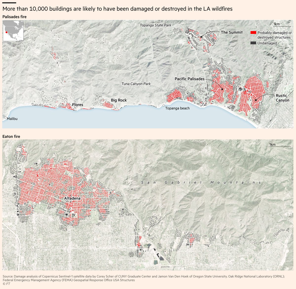


To conduct this analysis, we relied on @coreymaps and @jamonvdh’s excellent damage maps and estimates, which are based on Sentinel-1 satellite radar analysis. Combined with Microsoft building footprints, they allow you to make a map of damage (in red) that can look like this:


Almost as many buildings have been destroyed or damaged in Gaza as in all of Ukraine after its first two years of war with Russia, according to Corey Scher and Jamon Van Den Hoek, U.S.-based researchers who use satellite radar to document the wars’ devastation.…
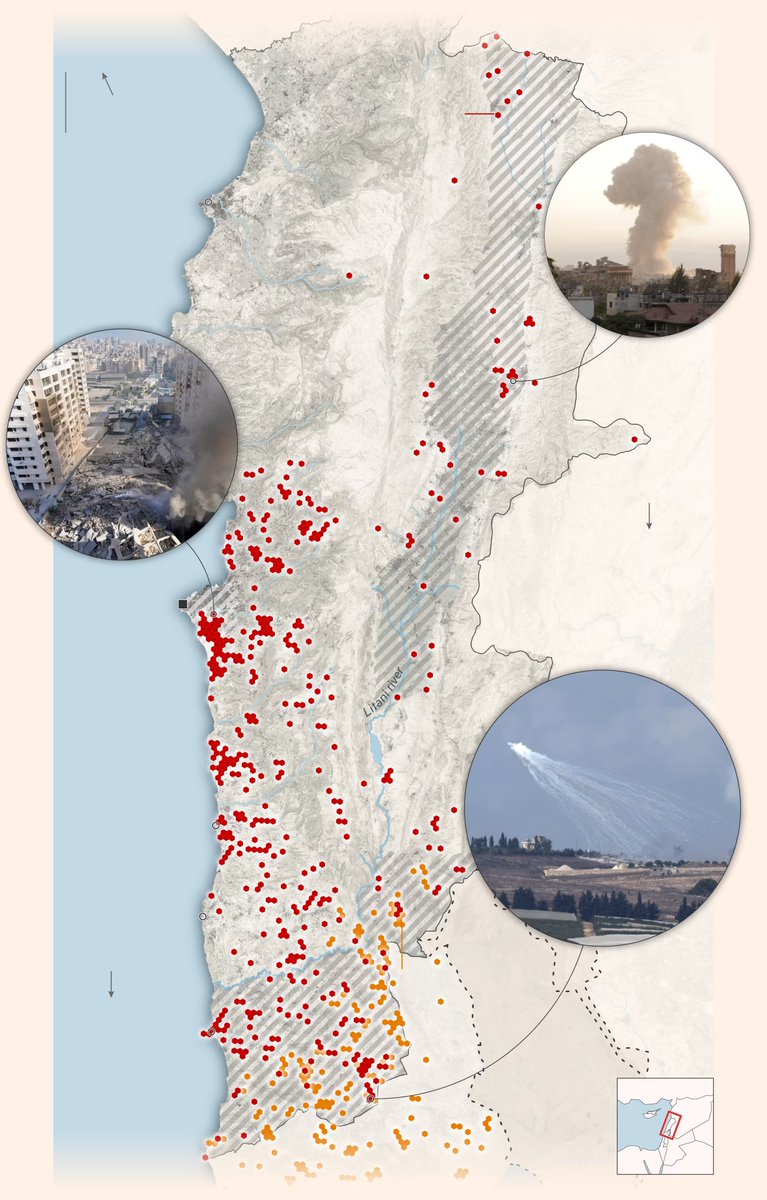
Satellite data shows more than 3,100 buildings affected by Israeli strikes on Lebanon. Important analysis by @FT in collaboration with @coreymaps and @JamonVDH. ft.com/content/e646b8…


Using Sentinel-1 satellite imagery, academics @JamonVDH and @coreymaps have estimated the likely damage to buildings over each month of the war. The damage now stands at 59% of all buildings

This follows a similar piece - with @rayajalabi and @malaika_tapper - on Israel’s strikes on Lebanon, using the clever @coreymaps radar analysis Israel’s push to create a ‘dead zone’ in Lebanon on.ft.com/3xq67aN

On Israel’s north: We thought we lived in Tuscany’: Hizbollah strikes ravage Israel’s north on.ft.com/46wqakM By @JamesShotter, @NeriZilber, me and @AditiHBhandari. Feat some ingenious work by @coreymaps and @hyinhe to track damage.


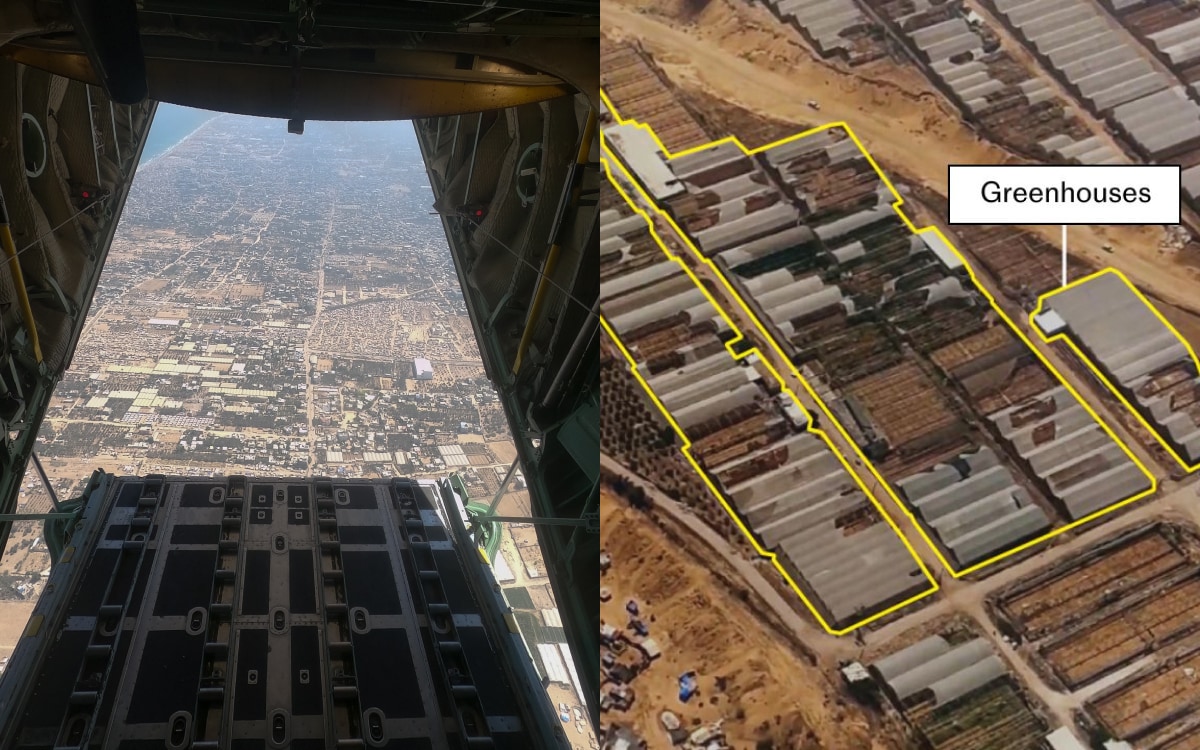
What #Gaza looks like today… I went w #Jordan’s Royal Air Force on a humanitarian aid drop & captured rare images of the destruction after 10 mos of #war @Telegraph geolocated what it all used to be - orchards, wedding venue, mosques, whole villages telegraph.co.uk/world-news/202…
The ongoing bombings on the borders between Israel and Lebanon resulting already in severe destruction of houses, displacement and affected agricultural areas, new #remotesensing analysis by @coreymaps / @JamonVDH @hyinhe shows. Good @BBC piece below bbc.com/news/articles/…


We are seeking abstracts for our AGU session "Tracking the Footprint of War: Earth and Environmental Science Perspectives on Monitoring Conflict Impacts" happening between 9-13 Dec 2024 in Washington, D.C. agu.confex.com/agu/agu24/prel…


An incredible collection and analysis of geographic and spatial data from @coreymaps and @JamonVDH on the destruction across Ukraine. nytimes.com/interactive/20…


Incredible deep dive on the destruction of #Ukraine - with beautiful images of Marinka - by @TmarcoH, with @coreymaps and @JamonVDH always powering good work. nytimes.com/interactive/20…
A reconstruction of #Ukraine's destruction - so well done by @TmarcoH, with @coreymaps and @JamonVDH

I spend months using satellites to trace what years of war have done to settlements in Ukraine nytimes.com/interactive/20…


United States 趨勢
- 1. Jets 77.3K posts
- 2. Jets 77.3K posts
- 3. Justin Fields 7,479 posts
- 4. Aaron Glenn 3,971 posts
- 5. #HardRockBet 3,194 posts
- 6. Garrett Wilson 3,036 posts
- 7. London 209K posts
- 8. Sean Payton 1,349 posts
- 9. HAPPY BIRTHDAY JIMIN 127K posts
- 10. Tyrod 1,330 posts
- 11. #OurMuseJimin 171K posts
- 12. #DENvsNYJ 1,981 posts
- 13. Bo Nix 2,588 posts
- 14. #JetUp 1,833 posts
- 15. #30YearsofLove 153K posts
- 16. Peart 1,849 posts
- 17. Bam Knight N/A
- 18. Kurt Warner N/A
- 19. Hail Mary 2,512 posts
- 20. Rich Eisen N/A
你可能會喜歡


Something went wrong.
Something went wrong.