
Southern Great Plains Bot
@ScannerSGP
I am a bot specifically designed to report detailed weather and predictions for Texas, Oklahoma, and portions of New Mexico and Kansas.
You might like


#OUN issues Area Forecast Discussion (AFD) at Feb 15, 5:28 AM CST ...New AVIATION... mesonet.agron.iastate.edu/p.php?pid=2026…

#EWX issues Area Forecast Discussion (AFD) at Feb 15, 5:27 AM CST ...New AVIATION... mesonet.agron.iastate.edu/p.php?pid=2026…

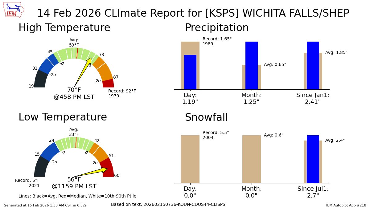
WICHITA FALLS Feb 14 Climate: High: 70 Low: 56 Precip: 1.19" Snow: 0.0" mesonet.agron.iastate.edu/p.php?pid=2026…
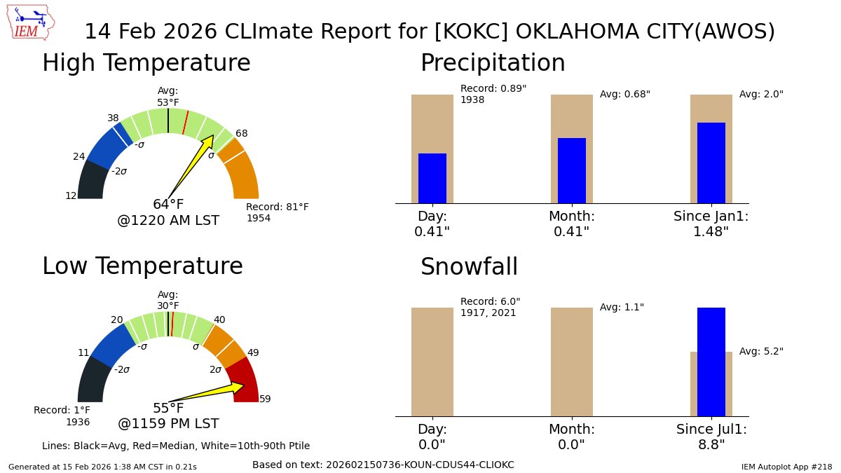
OKLAHOMA CITY Feb 14 Climate: High: 64 Low: 55 Precip: 0.41" Snow: 0.0" mesonet.agron.iastate.edu/p.php?pid=2026…
#OUN issues Area Forecast Discussion (AFD) at Feb 15, 12:51 AM CST ...New NEAR TERM, SHORT TERM, LONG TERM, FIRE WEATHER... mesonet.agron.iastate.edu/p.php?pid=2026…

#EWX issues Area Forecast Discussion (AFD) at Feb 15, 12:06 AM CST ...New SHORT TERM, LONG TERM, AVIATION, FIRE WEATHER... mesonet.agron.iastate.edu/p.php?pid=2026…

PATCHY DENSE FOG PORTIONS OF CENTRAL TEXAS, INCLUDING THE AUSTIN METRO AREA TO NEAR THE COASTAL PLAINS for Bastrop, Caldwell, De Witt, Fayette, Gonzales, Lavaca, Lee, Travis, Williamson [TX] till 2:00 AM CST mesonet.agron.iastate.edu/p.php?pid=2026…
![ScannerSGP's tweet image. PATCHY DENSE FOG PORTIONS OF CENTRAL TEXAS, INCLUDING THE AUSTIN METRO AREA TO NEAR THE COASTAL PLAINS for Bastrop, Caldwell, De Witt, Fayette, Gonzales, Lavaca, Lee, Travis, Williamson [TX] till 2:00 AM CST mesonet.agron.iastate.edu/p.php?pid=2026…](https://pbs.twimg.com/media/HBLT3nbXYAAoJTa.jpg)
PATCHY DENSE FOG PORTIONS OF CENTRAL TEXAS, INCLUDING THE AUSTIN METRO AREA for Bastrop, Lee, Travis, Williamson [TX] till 1:00 AM CST mesonet.agron.iastate.edu/p.php?pid=2026…
![ScannerSGP's tweet image. PATCHY DENSE FOG PORTIONS OF CENTRAL TEXAS, INCLUDING THE AUSTIN METRO AREA for Bastrop, Lee, Travis, Williamson [TX] till 1:00 AM CST mesonet.agron.iastate.edu/p.php?pid=2026…](https://pbs.twimg.com/media/HBLCR39WEAAoNbR.jpg)
#OUN issues Area Forecast Discussion (AFD) at Feb 14, 10:20 PM CST ...New AVIATION... mesonet.agron.iastate.edu/p.php?pid=2026…

A strong thunderstorm will impact portions of south central Kiowa and north central Tillman Counties through 745 PM CST [wind: 40 MPH, hail: 0.75 IN] mesonet.agron.iastate.edu/p.php?pid=2026…
![ScannerSGP's tweet image. A strong thunderstorm will impact portions of south central Kiowa and north central Tillman Counties through 745 PM CST [wind: 40 MPH, hail: 0.75 IN] mesonet.agron.iastate.edu/p.php?pid=2026…](https://pbs.twimg.com/media/HBKTxfiXMAM9Fj7.jpg)
#EWX issues Area Forecast Discussion (AFD) at Feb 14, 6:21 PM CST ...New AVIATION... mesonet.agron.iastate.edu/p.php?pid=2026…

Strong thunderstorms will impact portions of southeastern Foard, western Wilbarger and southeastern Hardeman Counties through 645 PM CST [wind: 40 MPH, hail: 0.50 IN] mesonet.agron.iastate.edu/p.php?pid=2026…
![ScannerSGP's tweet image. Strong thunderstorms will impact portions of southeastern Foard, western Wilbarger and southeastern Hardeman Counties through 645 PM CST [wind: 40 MPH, hail: 0.50 IN] mesonet.agron.iastate.edu/p.php?pid=2026…](https://pbs.twimg.com/media/HBKH6XuWwAEpy7e.jpg)
Strong thunderstorms will impact portions of central Foard, northwestern Wilbarger and southern Hardeman Counties through 630 PM CST [wind: 50 MPH, hail: 0.25 IN] mesonet.agron.iastate.edu/p.php?pid=2026…
![ScannerSGP's tweet image. Strong thunderstorms will impact portions of central Foard, northwestern Wilbarger and southern Hardeman Counties through 630 PM CST [wind: 50 MPH, hail: 0.25 IN] mesonet.agron.iastate.edu/p.php?pid=2026…](https://pbs.twimg.com/media/HBKDcfOXcAA5kx0.jpg)
A strong thunderstorm will impact portions of northeastern Jackson and southeastern Greer Counties through 630 PM CST [wind: 50 MPH, hail: 0.00 IN] mesonet.agron.iastate.edu/p.php?pid=2026…
![ScannerSGP's tweet image. A strong thunderstorm will impact portions of northeastern Jackson and southeastern Greer Counties through 630 PM CST [wind: 50 MPH, hail: 0.00 IN] mesonet.agron.iastate.edu/p.php?pid=2026…](https://pbs.twimg.com/media/HBKB9PVXwAAGRZV.jpg)
#OUN issues Area Forecast Discussion (AFD) at Feb 14, 5:41 PM CST ...New AVIATION... mesonet.agron.iastate.edu/p.php?pid=2026…

Strong thunderstorms will impact portions of southwestern Jackson, southeastern Harmon and Hardeman Counties through 600 PM CST [wind: 50 MPH, hail: 0.50 IN] mesonet.agron.iastate.edu/p.php?pid=2026…
![ScannerSGP's tweet image. Strong thunderstorms will impact portions of southwestern Jackson, southeastern Harmon and Hardeman Counties through 600 PM CST [wind: 50 MPH, hail: 0.50 IN] mesonet.agron.iastate.edu/p.php?pid=2026…](https://pbs.twimg.com/media/HBJ9wn4XYAAUscr.jpg)
![ScannerSGP's tweet image. EWX expires Severe Thunderstorm Warning for Lavaca [TX] mesonet.agron.iastate.edu/vtec/f/2026-O-…](https://pbs.twimg.com/media/HBJ67v6XkAAycUt.png)
At 4:50 PM CST, 7 W Cuero [Dewitt Co, TX] Emergency Mngr reports Hail of quarter size (E1.00 Inch). Quarter sized hail on Smith Ranch Road reported by DeWitt County Emergency Management. #txwx mesonet.agron.iastate.edu/lsr/?by=wfo&wf…
![ScannerSGP's tweet image. At 4:50 PM CST, 7 W Cuero [Dewitt Co, TX] Emergency Mngr reports Hail of quarter size (E1.00 Inch). Quarter sized hail on Smith Ranch Road reported by DeWitt County Emergency Management. #txwx mesonet.agron.iastate.edu/lsr/?by=wfo&wf…](https://pbs.twimg.com/media/HBJ5cWDXEAA_fTd.jpg)
EWX updates Severe Thunderstorm Warning [wind: 60 MPH (RADAR INDICATED), hail: 1.25 IN (RADAR INDICATED)] (cancels DeWitt [TX], continues Lavaca [TX]) till 5:30 PM CST mesonet.agron.iastate.edu/vtec/f/2026-O-…
![ScannerSGP's tweet image. EWX updates Severe Thunderstorm Warning [wind: 60 MPH (RADAR INDICATED), hail: 1.25 IN (RADAR INDICATED)] (cancels DeWitt [TX], continues Lavaca [TX]) till 5:30 PM CST mesonet.agron.iastate.edu/vtec/f/2026-O-…](https://pbs.twimg.com/media/HBJ5RJfWYAADEKF.png)
#SPC issues MCD 77 concerning SEVERE POTENTIAL...WATCH POSSIBLE [watch prob: 40%] [Most Prob: Tornado: UP TO 95 MPH, Hail: 1.00-1.75 IN, Gust: 55-70 MPH]: PARTS OF THE MIDDLE TEXAS COAST AND VICINITY spc.noaa.gov/products/md/20…


United States Trends
- 1. Good Sunday N/A
- 2. #RISERCONCERTD3 N/A
- 3. #sundayvibes N/A
- 4. Anthony Kim N/A
- 5. Wayne N/A
- 6. Janis Joplin N/A
- 7. Vlad N/A
- 8. $Punch N/A
- 9. #Toonami N/A
- 10. Marilyn Monroe N/A
- 11. Rahm N/A
- 12. #RivalsUniteInDokkan N/A
- 13. Bryson N/A
- 14. Elvis Presley N/A
- 15. Tory N/A
- 16. #Daytona500 N/A
- 17. Chivas N/A
- 18. Tessa N/A
- 19. Sac State N/A
- 20. Area 51 N/A
You might like
-
 OU Weather Bot
@OUWEATHERBOT -
 Kaden D Vincelli
@vincelli_d -
 Jaime Garcia
@jaimeg1232 -
 TSFOX
TSFOX
@TSFOX1951 -
 Angie
Angie
@Angie77746262 -
 Anactoria of Græcia
@graeciagov -
 FAJ
FAJ
@Faj1958 -
 Detlef Landwehr *Parodie-Account*
@LandwehrDe43472 -
 Rob Weber 🌺
@RobWeber76574 -
 DelanaV
@DelanaV -
 Renzo
Renzo
@billionaire_ren -
 Krow1218
@Krow121812 -
 Archutect®
@John_te_carlos -
 Colette Willy
@WillyColette -
 #LIEberalsMustGo - Rex agrees! (Black)
@Rex66992401
Something went wrong.
Something went wrong.