#txwx search results

A look at the Borderland forecast temperatures this week (daily highs and lows). Cool to start, but warming quickly above normal. Then moderate mid week and beyond, must a bit above average. #nmwx #txwx


(9:06PM) Storms are no longer severe, but there are still some heavy downpours with frequent lightning moving over areas north of highway 380 in Denton, Grayson, and Collin county. We'll monitor these as they work into areas NE of DFW, but should stay below severe limits. #TXwx


9:57AM Saturday 4/18 | Expect warm and muggy conditions with wind gusts up to 30mph. Rain and storms will filter in overnight and will become more widespread throughout the day Sunday. #RGVWX #TXWX


#TXWX How much rain??? This is the European rainfall accumulation model for Texas through next Thursday night.

105 AM - A line of strong thunderstorms continues to move towards the southeast this morning. The main hazards will be small hail and strong winds. #okwx #txwx


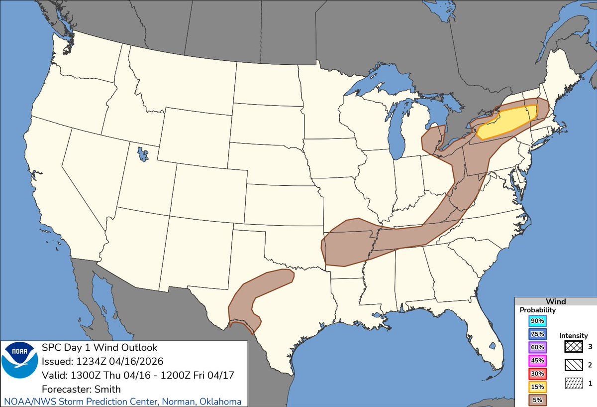
We have slight risks of severe storms this afternoon for New York into southern Vermont and over the northern half of Arkansas for damaging winds, large hail and isolated tornadoes possible #txwx #okwx #arwx #mowx #tnwx #mswx #kywx #wvwx #vawx #ohwx #miwx #pawx #nywx #vtwx #mawx


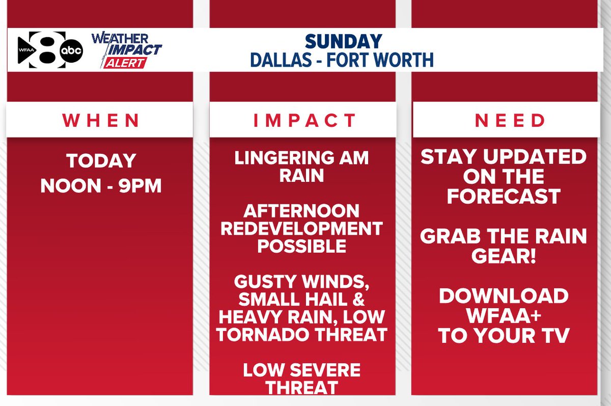
Our WFAA Weather Alert is from Noon today until 9 PM. Storms that redevelop this afternoon will pose a risk for 50-60 mph wind gusts, up to quarter size hail, and a very low (just not zero) tornado threat. #txwx

10:45 AM Update: A few showers are moving east across the metroplex. No lightning with these at the moment. #txwx


Multiple cars stranded due to high water. Turn Around Don’t Drown Houston Lockwood under Texas Spur @abc13houston @TxStormChasers @accuweather @NWSHouston #houwx #htx #TXWX #hounews
Thanks to Canadian high pressure exiting our Four-State area, along with thin high clouds and a S/SE wind around 10 mph, we will see a great start to the week. A warming trend resumes tonight with more needed rainfall on the way. #okwx #lawx #txwx #arwx


#Fiesta continue this week for San Antonio and while the rain will SLOWLY come to an end...NIOSA will start off damp, cool and wet Tuesday night. Only isolated showers and storms likely into the weekend. #txwx

8:20 AM - Showers and storms continue to form and push east this morning. We'll be in this rainy pattern at least through Tuesday night before rain chances trend down. Some high water and minor flooding may occur in your area as more rain pushes through overnight. #txwx


Good morning! Today will be Showers with a high of 65F and a low of 58F. Full forecast for Pflugerville: ift.tt/AlxuzrU #atxwx #txwx #weather

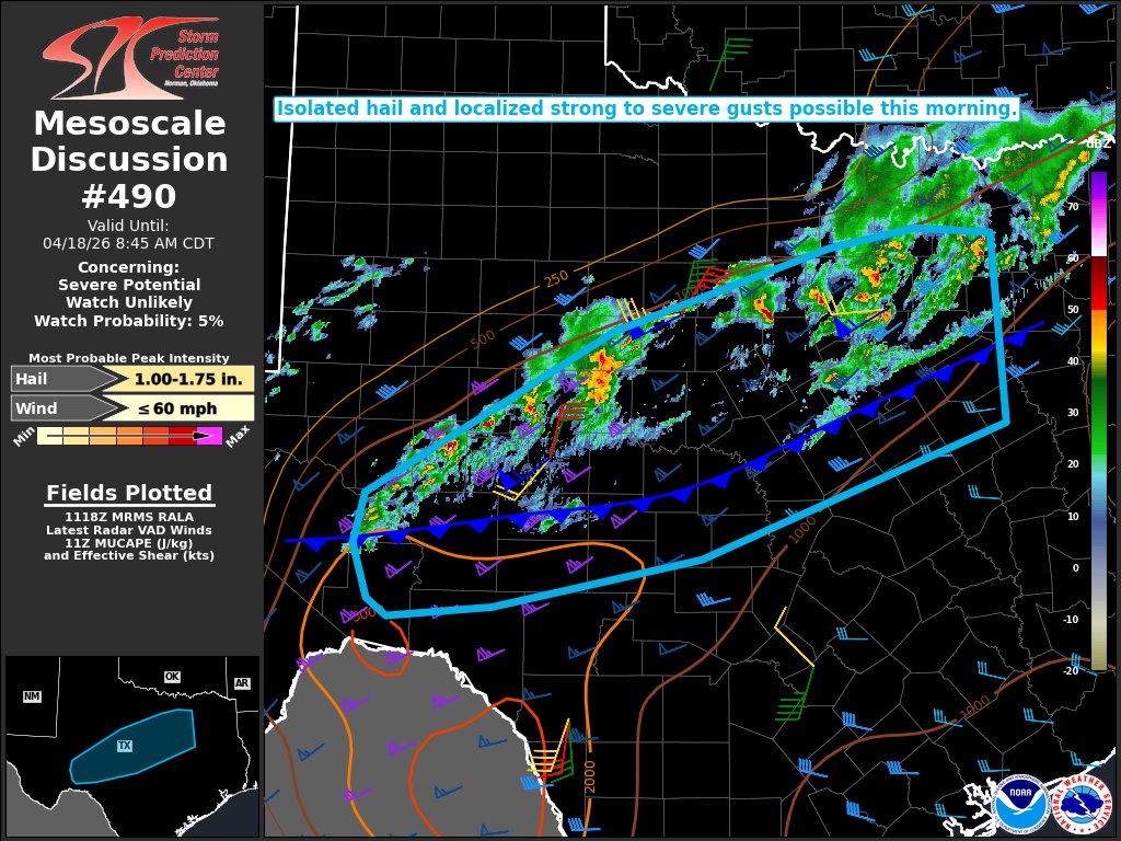
SPC has maintained its "Slight" risk outline across roughly our northern half for Friday of this week. #etxwx #txwx

[7:05 AM | 4/20/26] Good morning, we're off the a cloudy, but mainly dry start to the day. Rain chances will return this afternoon. The best chance for rain will be closer to the coast. Temperatures will warm up into the mid 70s. #RGVWX #TXWX
![KRGV_Weather's tweet image. [7:05 AM | 4/20/26] Good morning, we're off the a cloudy, but mainly dry start to the day. Rain chances will return this afternoon. The best chance for rain will be closer to the coast. Temperatures will warm up into the mid 70s.
#RGVWX #TXWX](https://pbs.twimg.com/media/HGWPO8XXAAEdeIl.jpg)

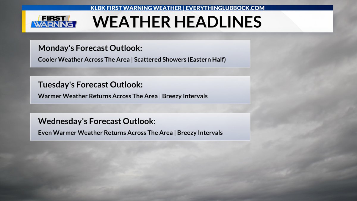
Good Morning! Here's my update on your work and school week forecast across the South Plains and the Rolling Plains on this Monday. #txwx #KLBK #Lubbock (Click on the image below to link to the full forecast.) everythinglubbock.com/weather/klbk-m…

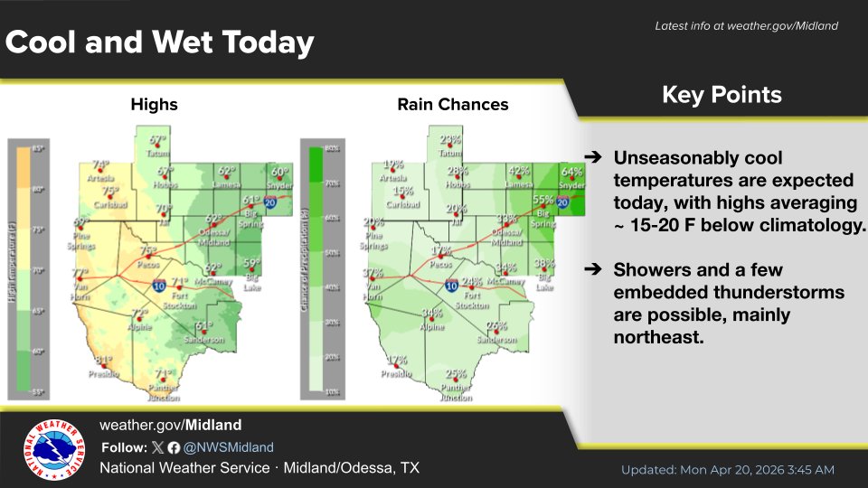
Unseasonably cool temperatures are expected today, with highs averaging ~ 15-20 F below climatology. Showers and a few embedded thunderstorms are possible, mainly northeast. #txwx #nmwx

Good Morning! Here's Meteorologist Chris Whited's update on your work and school week forecast across the South Plains and the Rolling Plains on this Monday. #txwx #KLBK #Lubbock (Click on the image below to link to the full forecast.) everythinglubbock.com/weather/klbk-m…

If you are looking for the DOC OIG Review of the National Weather Service’s Actions to Support Kerr County During the Catastrophic Flash Flood in Texas (OIG-26-017-I) its here: oversight.gov/sites/default/… #TXwx #Texas #TexasFloods #HillCountryFloods #KerrCounty
Turn Around Don’t Drown Houston. Saturday Afternoon April 18, 2026 Footage of Flooding as major freeway closes I-10 at McCarty Street in both directions @abc13houston @TxStormChasers #houwx #htx #TXWX #hounews #flooding #texas #rain

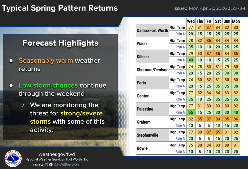
Low storm chances (10-40%) will persist through the weekend with temperatures warming back into the 80s. We're monitoring the potential for some of these storms to become strong or severe, but widespread severe weather is not expected at this time. #dfwwx #ctxwx #txwx
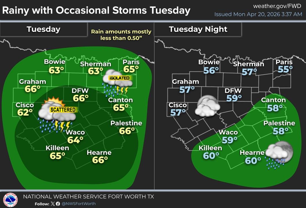
Most areas stay dry today, but rain & isolated storms will gradually move in across the west. Higher coverage is then expected overnight and during the day Tuesday. Any areas with storms will see a bit higher totals, but most locations will get less than an inch. #dfwwx #txwx

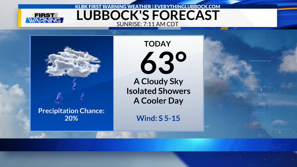
Here's my Monday forecast for the #Lubbock metro area. A mostly cloudy to cloudy day and cooler. Isolated rain showers in the morning and in the afternoon. High around 63° with a southerly wind 5-15 mph. Sunrise is at 7:11 AM CDT. #txwx #KLBK

Here's our Monday forecast for the #Lubbock metro area. A mostly cloudy to cloudy day and cooler. Isolated rain showers in the morning and in the afternoon. High around 63° with a southerly wind 5-15 mph. Sunrise is at 7:11 AM CDT. #txwx #KLBK
04/19/26 Time Lapse! #txwx #timelapse #sky #alldayvideo #lakealanhenry #garzacountytx #weathercam youtu.be/pXVKYWXxBEo

youtube.com
YouTube
Lake Alan Henry Weather

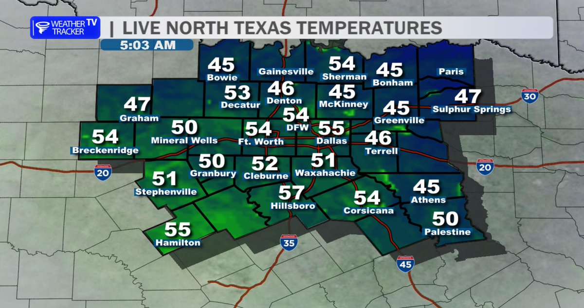
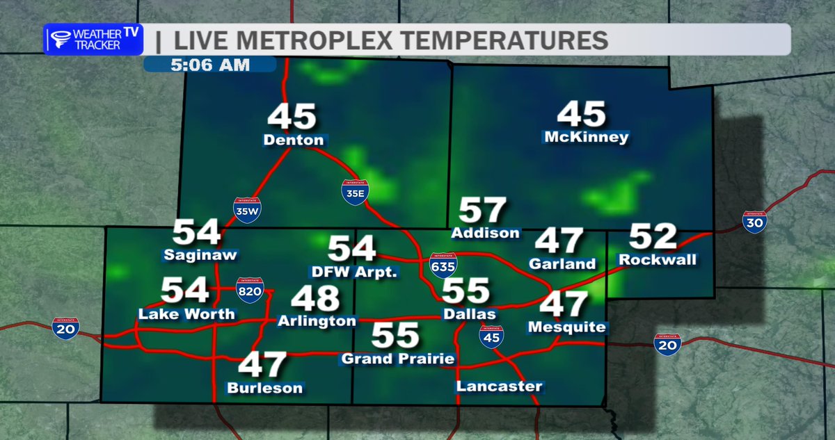
5:20 AM: Good Monday morning! It's a cool start with temperatures in the 40s and 50s around North Texas. ☕️ Right now, traffic flow looks good in Dallas County as the morning commute begins. 🚗💨 #dfwwx #txwx


Good Morning! Here's a look at our weather headlines across the South and Rolling Plains on this Monday and over the next couple of days. Meteorologist Chris Whited has your full forecast update at 6:00 a.m. on #KLBK Rise & Smile and later on KLBK News at Noon. #txwx #Lubbock

Good Morning! Here's a look at my weather headlines across the South Plains and Rolling Plains on this Monday and over the next couple of days. I'll have your full forecast update coming up at 6:00 a.m. on #KLBK Rise & Smile and later on KLBK News at Noon. #txwx #Lubbock


Temperatures remain below normal through midweek. Rain chances return Tuesday. Our next cold front arrives on Friday! #txwx


Rain coverage looks low over the next couple of weeks with up and down temperatures! We will have pretty comfortable afternoon highs this weekend. #txwx

Storm coverage looks highest this week on Wednesday. Temperatures stay warm and we stay pretty windy! A cold front comes in on Saturday. #txwx


Something went wrong.
Something went wrong.
United States Trends
- 1. Happy 420 N/A
- 2. AJ Brown N/A
- 3. Good Monday N/A
- 4. #MondayMotivation N/A
- 5. #MCMRechazadaPorLaDerecha N/A
- 6. Trent Williams N/A
- 7. Jim Ryan N/A
- 8. Patrick Muldoon N/A
- 9. Boston Marathon N/A
- 10. Marathon Monday N/A
- 11. Schefter N/A
- 12. Howie N/A
- 13. #MondayVibes N/A
- 14. Melrose Place N/A
- 15. Broderick Jones N/A
- 16. Will Howard N/A
- 17. #FelizLunes N/A
- 18. Happy Patriots N/A
- 19. #PatriotsDay N/A
- 20. Detroit Lions N/A