
Cherokee County EM
@Tahlequah_EM
The official Twitter site of Cherokee County (OK) Emergency Management. Please follow NWS Tulsa for local watch & warning information.
You might like


REMINDER: City of Tahlequah will test its outdoor warning sirens at noon today. No severe weather is in the area. Thank you!
Perfect 2nd Saturday for an outdoor siren test in the city of Tahlequah. This will occur at noon today. No severe weather is in the area. Thank you.
Flood Watch issued for our immediate area. Weather Event Onset 1:00 AM (CDT), August 28 Description * WHAT...Flooding caused by excessive rainfall continues to be possible. weather.gov/safety/flood
REMINDER: weather permitting, the City of Tahlequah (OK) will test its outdoor warning system this Saturday, Aug. 9, at noon.

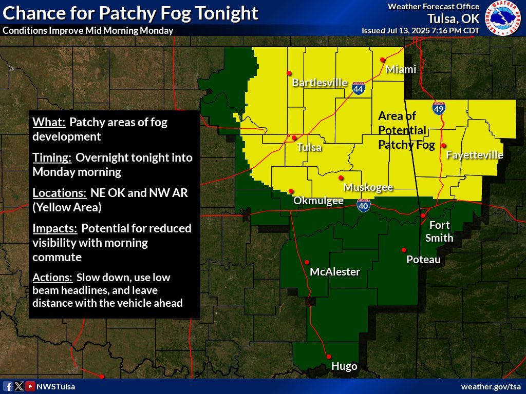

[8:15 PM 7/13/25] Shower/storm chances remain overnight tonight for much of E OK & NW AR w/the greater potential south of I-40 through late evening. Also tonight over NE OK & NW AR a potential for patchy areas of fog exists. Use caution while driving tonight. #okwx #arwx
![NWStulsa's tweet image. [8:15 PM 7/13/25] Shower/storm chances remain overnight tonight for much of E OK & NW AR w/the greater potential south of I-40 through late evening. Also tonight over NE OK & NW AR a potential for patchy areas of fog exists. Use caution while driving tonight.
#okwx #arwx](https://pbs.twimg.com/media/Gvx8luZW0AA6YrO.jpg)
![NWStulsa's tweet image. [8:15 PM 7/13/25] Shower/storm chances remain overnight tonight for much of E OK & NW AR w/the greater potential south of I-40 through late evening. Also tonight over NE OK & NW AR a potential for patchy areas of fog exists. Use caution while driving tonight.
#okwx #arwx](https://pbs.twimg.com/media/Gvx83txWMAAM5z1.jpg)

3:46am CDT #SPC Public Severe Weather Outlook #PWO concerning #arwx #mowx #okwx spc.noaa.gov/products/outlo…

Review your severe wx action plans and stay wx aware today. Storms start forming during the midday hours just to our west and spread into area during the afternoon, packing high-impact severe potential. This includes very large hail and strong tornadoes. #okwx #arwx
While the greatest severe impacts will likely be during the afternoon, some severe threat will linger into the evening as well until the cold front passes. Here is the latest estimated timing...#okwx #arwx

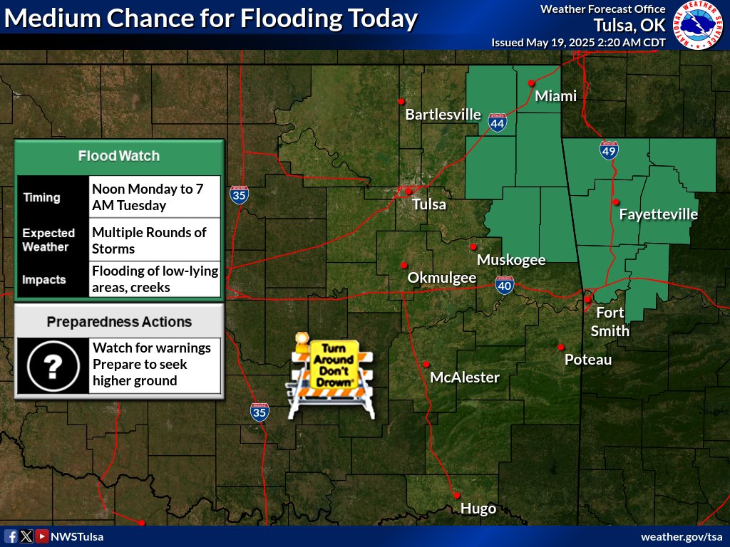
Heavy rains fell over NW #ARwx and far NE #OKwx yesterday. Multiple rounds of storms are expected thru tonight in those same areas, which could lead to dangerous flash flooding. A Flood Watch is in effect from noon today to 7 AM Tuesday morning. #TADD
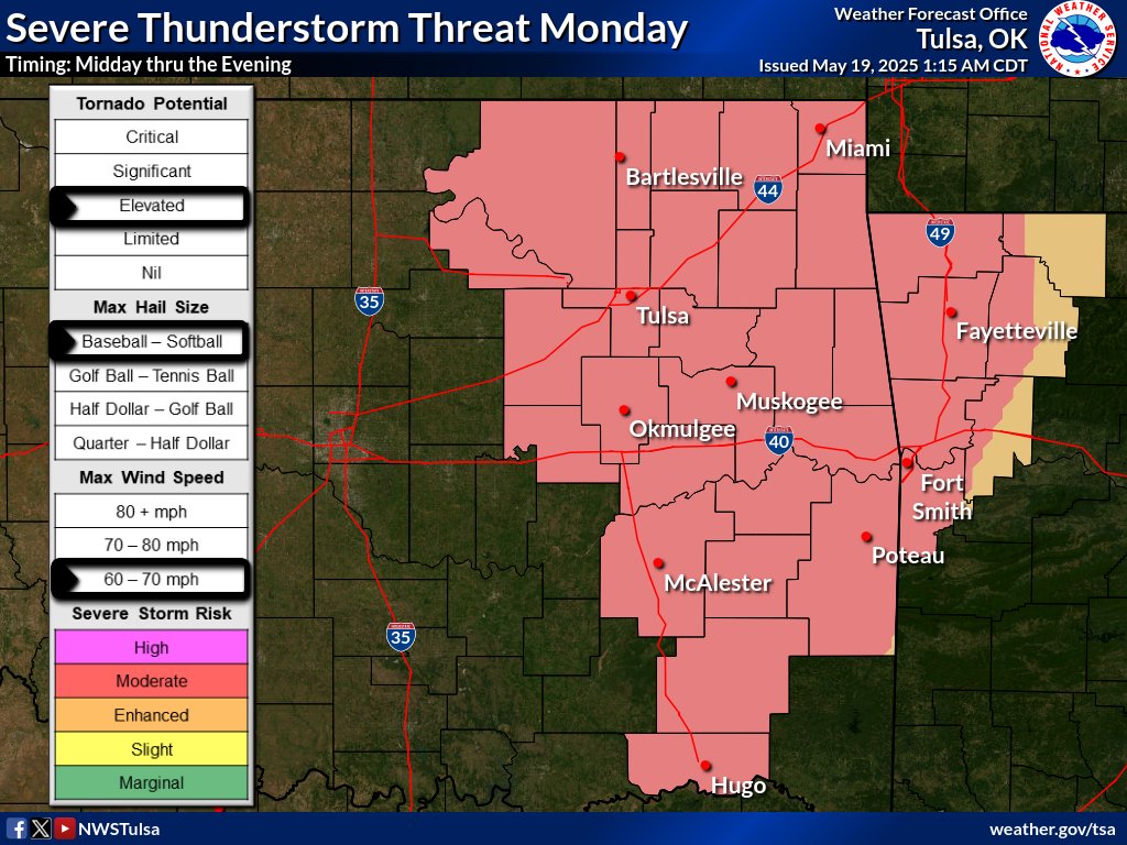
[7:14 am - 5/18/25] Severe thunderstorm potential remains today, again Monday, Monday night. The potential for tornadoes will be higher today and tomorrow than with the previous couple of days. Keep an eye on the forecast. Have multiple ways to receive weather info! #okwx #arwx
![NWStulsa's tweet image. [7:14 am - 5/18/25] Severe thunderstorm potential remains today, again Monday, Monday night. The potential for tornadoes will be higher today and tomorrow than with the previous couple of days. Keep an eye on the forecast. Have multiple ways to receive weather info! #okwx #arwx](https://pbs.twimg.com/media/GrOwb66WAAE6Fkx.jpg)
![NWStulsa's tweet image. [7:14 am - 5/18/25] Severe thunderstorm potential remains today, again Monday, Monday night. The potential for tornadoes will be higher today and tomorrow than with the previous couple of days. Keep an eye on the forecast. Have multiple ways to receive weather info! #okwx #arwx](https://pbs.twimg.com/media/GrOwb66WcAA8EW_.jpg)
![NWStulsa's tweet image. [7:14 am - 5/18/25] Severe thunderstorm potential remains today, again Monday, Monday night. The potential for tornadoes will be higher today and tomorrow than with the previous couple of days. Keep an eye on the forecast. Have multiple ways to receive weather info! #okwx #arwx](https://pbs.twimg.com/media/GrOwb64WkAECfW4.jpg)

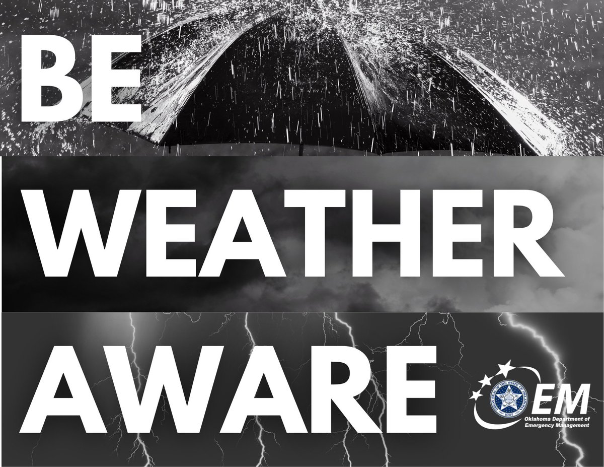
Be #WeatherAware Oklahoma! ⛈️ Severe weather is possible Friday evening/overnight and Saturday evening. Large hail, damaging winds, flash flooding, and tornadoes are possible. Have multiple ways of receive warnings and keep the volume turned up when you go to sleep. #okwx
[4:48 AM 4/18/25] Multiple rounds of widespread heavy rainfall are forecast Fri-Sun over E OK & NW AR in addition to the severe weather risks. Widespread 2-6 inches of rain w/locally toward 8 inches are forecast which will increase Flash Flood & River Flood concerns! #okwx #arwx
![NWStulsa's tweet image. [4:48 AM 4/18/25] Multiple rounds of widespread heavy rainfall are forecast Fri-Sun over E OK & NW AR in addition to the severe weather risks. Widespread 2-6 inches of rain w/locally toward 8 inches are forecast which will increase Flash Flood & River Flood concerns! #okwx #arwx](https://pbs.twimg.com/media/Gozu68-WAAEsmkB.jpg)
![NWStulsa's tweet image. [4:48 AM 4/18/25] Multiple rounds of widespread heavy rainfall are forecast Fri-Sun over E OK & NW AR in addition to the severe weather risks. Widespread 2-6 inches of rain w/locally toward 8 inches are forecast which will increase Flash Flood & River Flood concerns! #okwx #arwx](https://pbs.twimg.com/media/GozvbraXwAEbOsG.jpg)

CHEROKEE CO: All lanes of SH-51 are open a half a mile west of the SH-51 Spur junction in Tahlequah.
The city of Tahlequah (OK) will test outdoor warning sirens Saturday, April 12, at noon. No severe weather is expected in the area today.
BREAKING: County Commissioners have issued a 14-day BURN BAN for all of Cherokee County (OK) effective immediately.
UPDATE: Still expecting snow in Cherokee County tomorrow with possible freezing rain and sleet before it transitions to all snow. Accumulations will vary. Northern area could see 4+ inches while southern areas get 1-2 inches. Regardless, travel will become treacherous.


United States Trends
- 1. Good Thursday 24.5K posts
- 2. Happy Friday Eve N/A
- 3. #thursdaymotivation 1,452 posts
- 4. #หลิงออมปฏิทินช่อง3ปี2569 620K posts
- 5. #thursdayvibes 2,035 posts
- 6. LINGORM CH3 CALENDAR SIGN 618K posts
- 7. #ThursdayThoughts 1,422 posts
- 8. #ProofOfFortification N/A
- 9. Nnamdi Kanu 55.3K posts
- 10. FEMA 76.6K posts
- 11. But Jesus 21.9K posts
- 12. Knicks 14K posts
- 13. Shamet 3,115 posts
- 14. GM CT 23.6K posts
- 15. Crockett 57.2K posts
- 16. NO CAP 14.8K posts
- 17. FREE HAT 1,814 posts
- 18. Sam Harris 3,723 posts
- 19. Sheila Cherfilus-McCormick 57.2K posts
- 20. Poverty 81K posts


Something went wrong.
Something went wrong.