#weatheraware search results

A clear start does not guarantee a smooth finish. Some of the biggest disruptions on the course build in ways that change the round fast. #GolfLife #WeatherAware #PlaySmart


⚠️ Yellow weather warning issued ⚠️ Very strong winds across Scotland Saturday 1800 – Sunday 1200 Latest info 👉 bit.ly/WxWarning Stay #WeatherAware⚠️
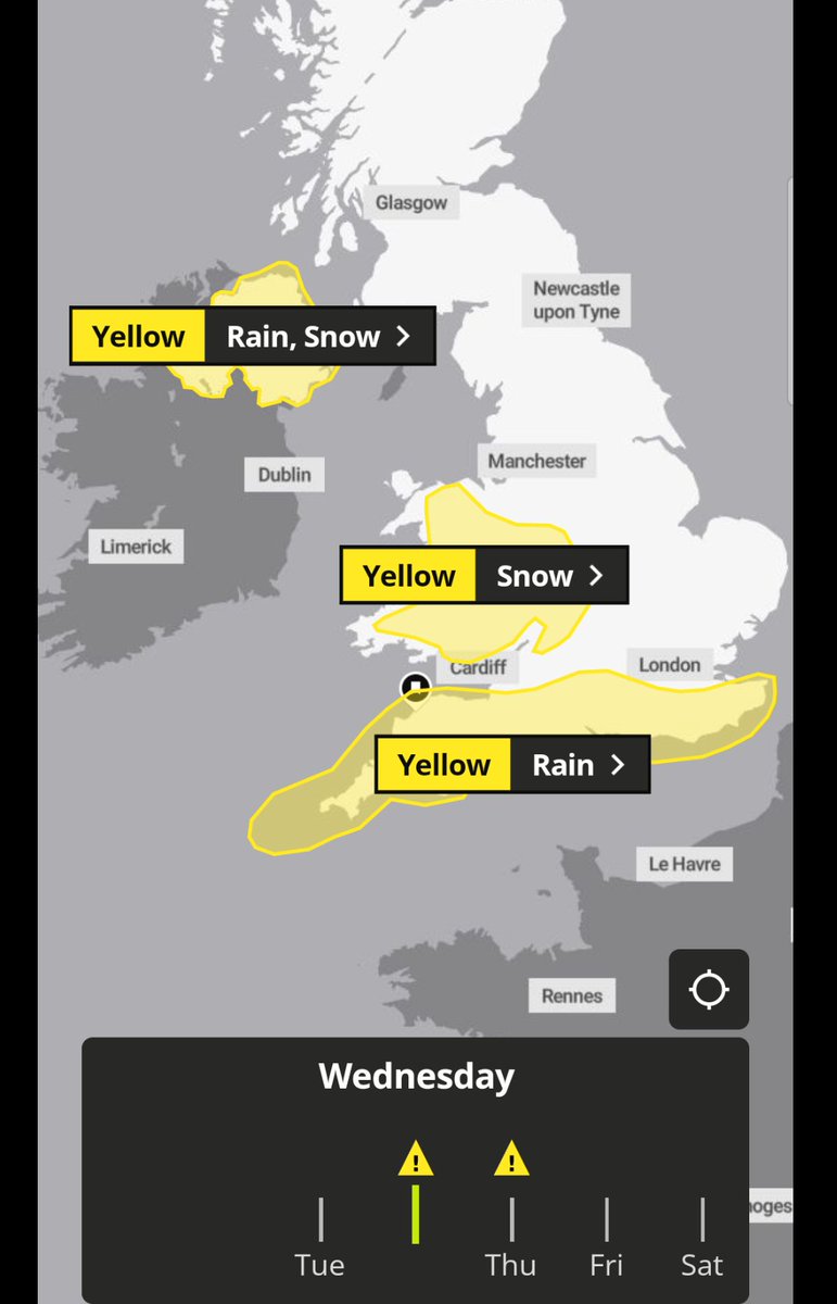
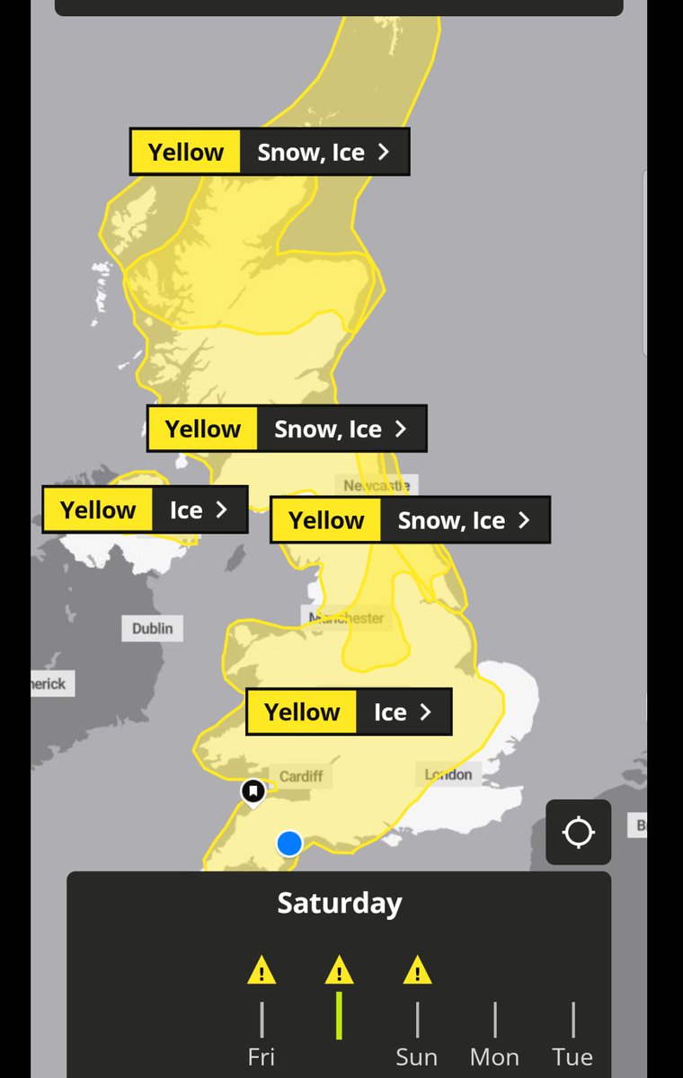
#Metoffice yellow warning ⚠️ for snow and ice issued for tomorrow morning #weatheraware metoffice.gov.uk

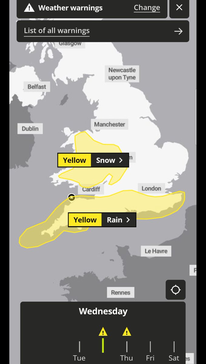
#Metoffice yellow warnings ⚠️ for rain and snow issued for Wednesday and Wednesday night #weatheraware metoffice.gov.uk
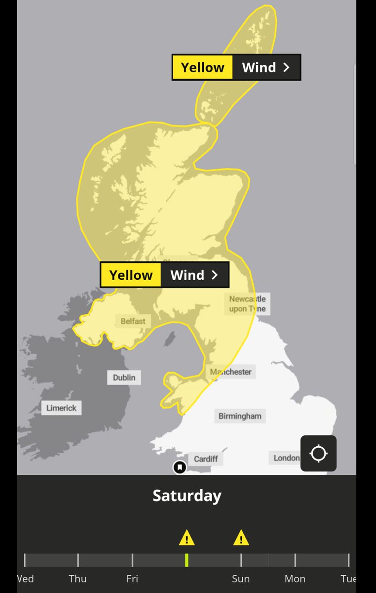
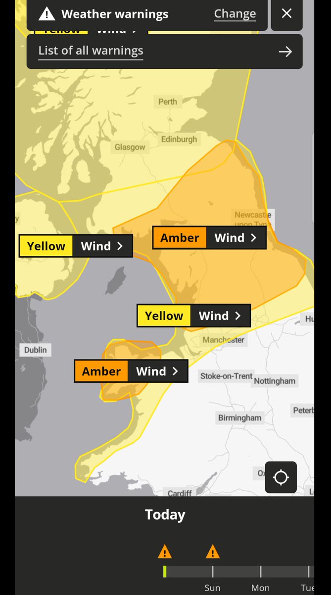
#Metoffice yellow warnings ⚠️ for #wind issued for Saturday evening through Sunday 85 to 90mph gusts possible #weatheraware metoffice.gov.uk

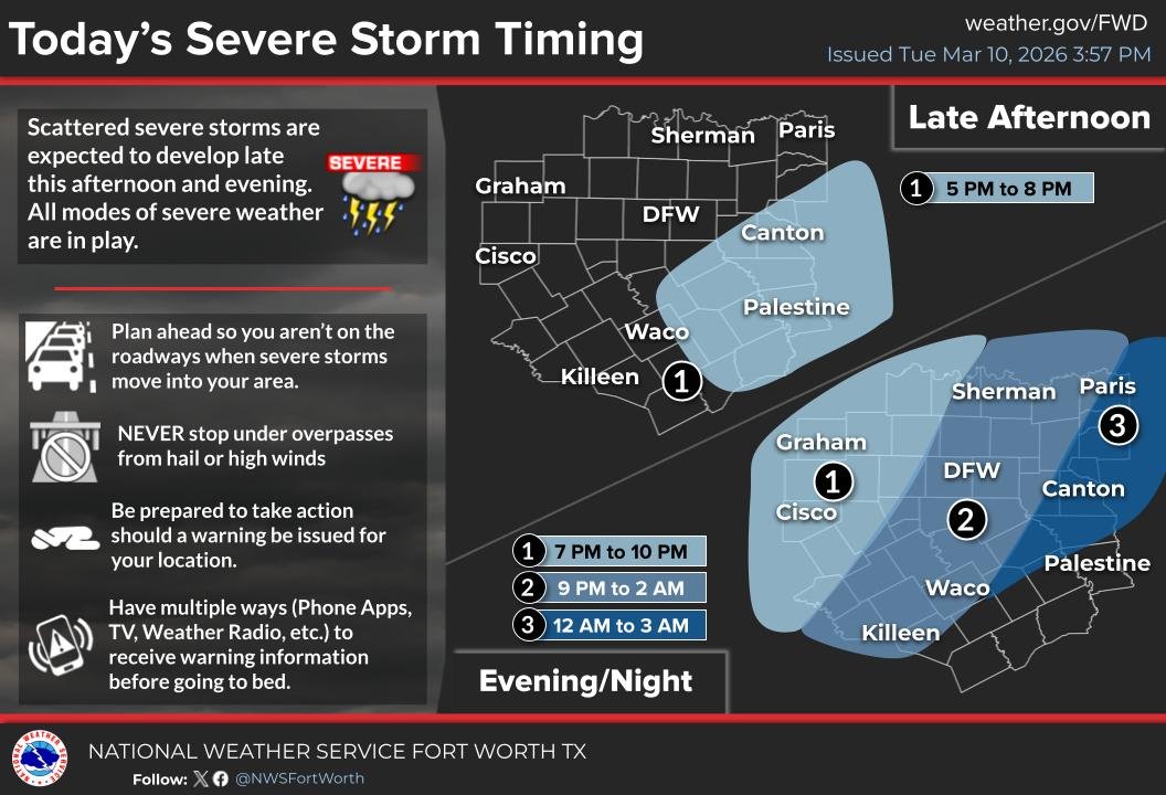
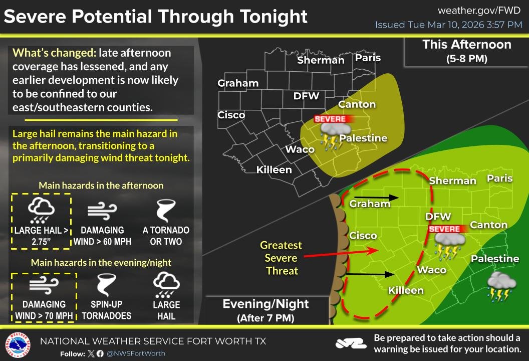
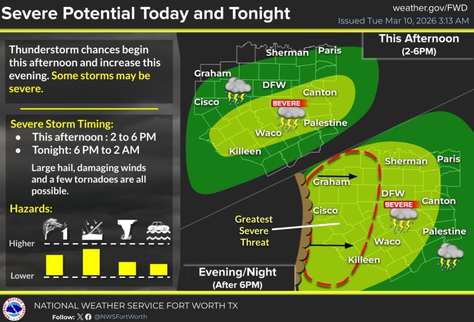
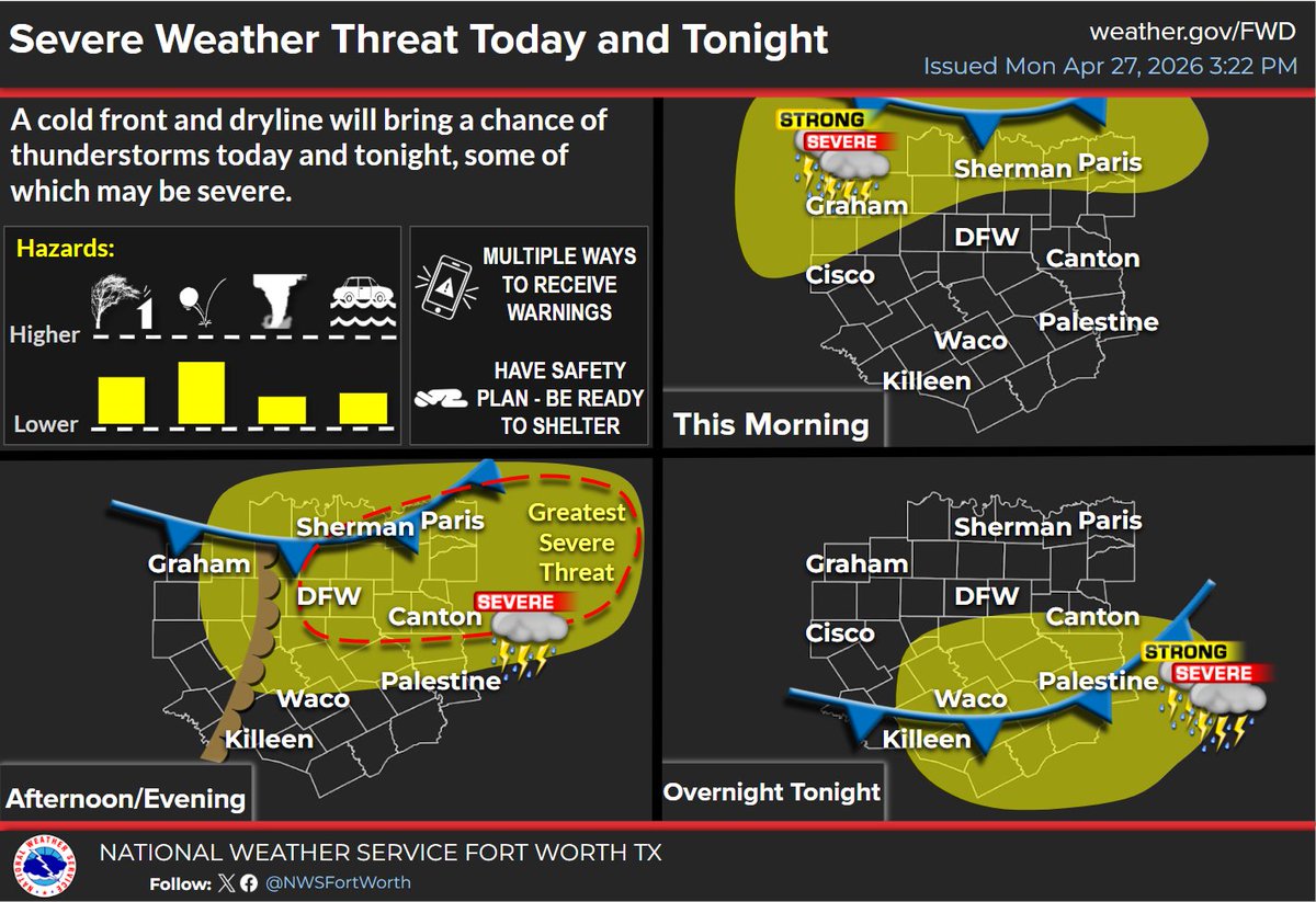
(4:45 p.m. 3/10/26) Continue to stay #WeatherAware as potential for severe weather will continue into tonight. A line of storms capable of producing damaging winds, large hail and spin up tornadoes is developing out west and expected to reach the metroplex between 9 p.m. and 2

4 PM Update: The potential for severe storms late this afternoon in portions of CTX continues. Storms will develop in this area closer to around 5 PM. The timing of the main line later tonight remains the same. All hazards remain possible, along with localized flooding. #txwx
#Metoffice AMBER wind warning ⚠️ issued for #StormDave tonight More details #weatheraware metoffice.gov.uk
2:50PM: We’re watching a few storms northwest of DFW. So far they have remained sub-severe, but we expect storms to intensify over the next few hours. Remain #WeatherAware this afternoon and evening. #txwx
3:00 PM: Areas east of DFW are starting to become more unstable, increasing the thunderstorm potential for the rest of this afternoon and evening. Remain #WeatherAware toddy! #txwx
#Metoffice yellow warning ⚠️ for rain and snow issued for N Ireland 0400 to 2000 tomorrow #weatheraware metoffice.gov.uk

🌧️ Driving in heavy rain? Stay safe. ✔️ Slow down – stopping distances increase. ✔️ Keep headlights on for visibility. ✔️ Leave extra space between vehicles. ✔️ Watch for standing water after sudden downpours. #WeatherReady #WeatherAware #TRIP
Please be #WeatherAware this evening, Frisco. The @NWSFortWorth has issued a Tornado Watch through 11 p.m. tonight for an area that includes Denton & Collin counties. Any severe storms that develop could produce tornadoes, large hail and gusty winds. Sign up for CodeRED alerts at
A tornado watch has been issued for parts of Oklahoma and Texas until 11 PM CDT

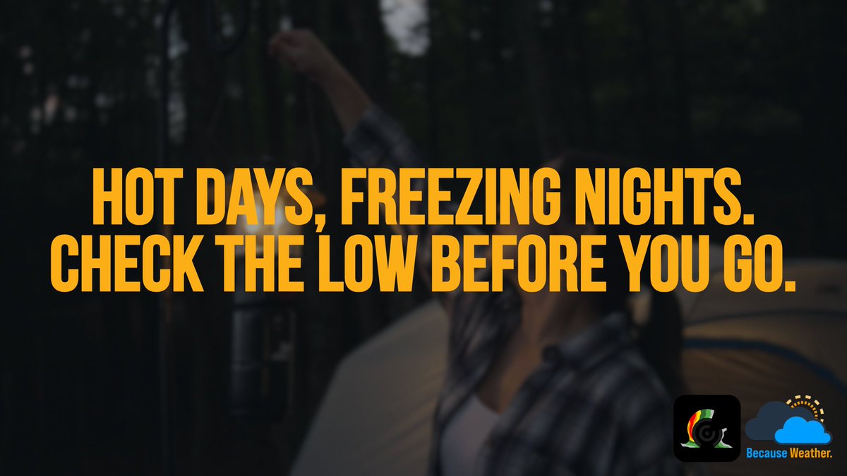
Desert temps can swing 30-40°F after sunset. 🌡️ Don’t let a warm afternoon fool you; pack layers, a proper sleeping bag, and a solid sleep system. 🌙 #DesertCamping #CampSmart #WeatherAware
Stay #weatheraware later today, Frisco. ⛈️The @NWSFortWorth forecasts the potential for severe storms late afternoon into overnight. Register for CodeRED alerts at FriscoTexas.gov/CodeRed. Get notifications if a warning is issued for your address. @FriscoFFD I @FriscoPD

2/26 - Fresh to strong southerly return flow across the NW Gulf will expand across the SW and central Gulf tonight into Thu ahead of the next cold front forecast to enter the NW Gulf early Fri. Latest marine forecast at hurricanes.gov/marine #marinewx #weatheraware⚓️
2/20 – A plume of Saharan dust continues moving west across the tropical Atlantic, suppressing shower and t’storm activity and reducing visibility. Latest marine forecast: hurricanes.gov/marine #marinewx #Saharandust #weatheraware


11:30 AM CST 03/05/2026 - Today’s tornado potential has slightly increased over southwestern Oklahoma and northeastern portions of the #KLBK forecast area. A bullseye has been placed over Childress, Quanah, Wellington, Magnum, Altus, and Eldorado. Stay #WeatherAware, and stick

Storm Claudia is here. Fri 14 & Sat 15 Nov will see heavy rainfall. We're re-checking culverts, gullies and drains to help rainwater drain away & our traffic officers, inspectors & control rooms are monitoring conditions 24/7. #WeatherReady #WeatherAware #TRIP

🌧️ Driving in heavy rain? Stay safe. ✔️ Slow down – stopping distances increase. ✔️ Keep headlights on for visibility. ✔️ Leave extra space between vehicles. ✔️ Watch for standing water after sudden downpours. #WeatherReady #WeatherAware #TRIP
A clear start does not guarantee a smooth finish. Some of the biggest disruptions on the course build in ways that change the round fast. #GolfLife #WeatherAware #PlaySmart

🌩️ Stay #WeatherAware today!
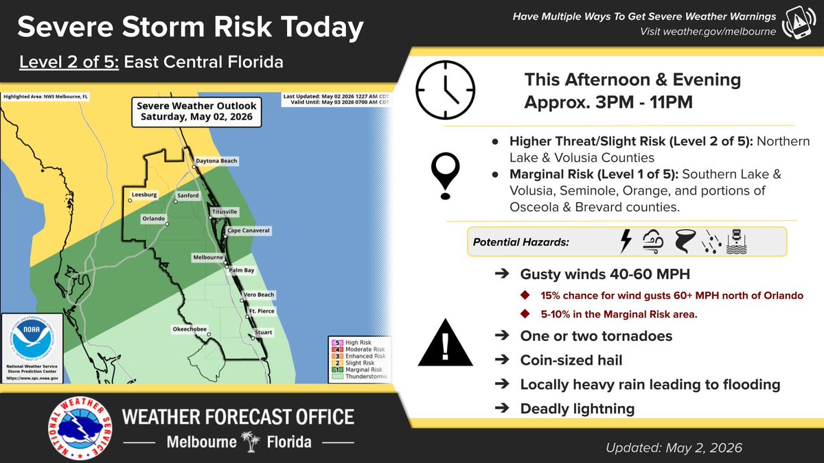
May 2 | Very active weather day. Wind gusts increase to 30-35 mph in the late morning, then hot as temps soar into the U80s-M90s, near record for the southern coast. In the afternoon & evening, a line of strong to severe lightning storms pushes through near/ahead of a front.


مع توقع هطول الأمطار، من المهم الاستعداد والبقاء آمنين على الطرق. تأكد من متابعة حالة الطقس طوال المساء. 🌧️ تحقق من حالة الطرق في الوقت الفعلي هنا: traffic.houstontranstar.org/layers/ 📍 #HouWX #WeatherAware
天气预报有降雨,做好准备并在道路上注意安全非常重要。请在今晚持续关注天气情况。🌧️ 在此查看实时道路状况:traffic.houstontranstar.org/layers/ 📍 #HouWX #WeatherAware
With rain in the forecast, it’s important to stay prepared and stay safe on the roads. Be sure to monitor weather conditions throughout the evening. 🌧️Check real-time road conditions here: traffic.houstontranstar.org/layers/ 📍 #HouWX #WeatherAware
Golf does not always stop because of your scorecard. Rain, fog, and soaked conditions can change the day quickly and turn a normal round into a waiting game! ☔️ #GolfLife #RainDelay #WeatherAware

Ready to run? 🏃♂️ Check the real conditions first. Heat. Humidity. Wind. It all adds up. AcuRite helps you run smarter—before you step outside. #RunSmart #WeatherAware #OutdoorFitness #AcuRite


Rain can change the pace of a round in a hurry. A dry start does not always last, and soggy fairways, paused play, and rushed decisions can follow fast. #GolfLife #RainDelay #WeatherAware
Rain can change the pace of a round in a hurry. A dry start does not always last, and soggy fairways, paused play, and rushed decisions can follow fast. #GolfLife #RainDelay #WeatherAware

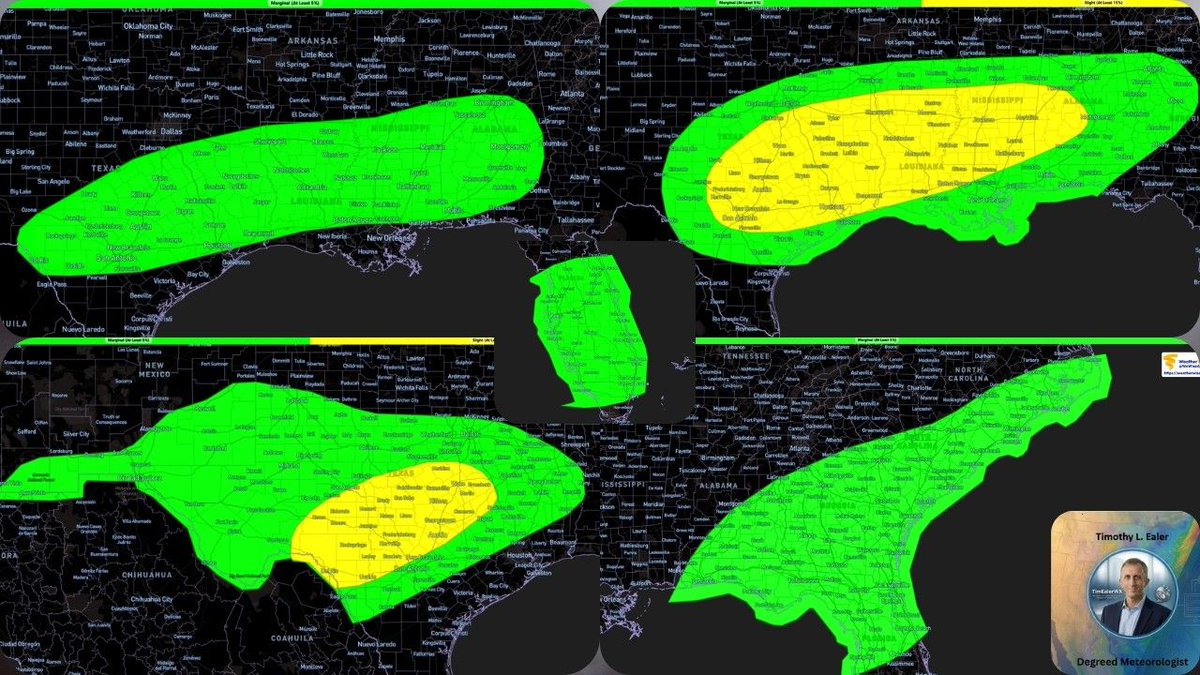
⛈️ New Forecast Discussion: We’ve got one more day of severe weather to navigate before heavy rain takes over for the weekend. From tornado risks in the Southeast to huge hail in Texas, get the full timing here: Forecast Discussion - youtu.be/-9pir9dFIKE #WeatherAware

WDEF-TV NEWS 12 WEATHER OVERTIME - TUE APR 28 2026 More severe weather potential tonight. Time to be #WeatherAware. Catch the repeat performance of tonight's WDEF News 12 exclusive video #weatherblog #WeatherOvertime. youtube.com/live/GtBHVr4Ng…


Good Tuesday evening folks, we hope y’all have a good and safe night. According to the National Weather Service, more rain and the possibility of severe weather will move in overnight. Keep weather alerts on and stay weather aware! #GoodnightHaralson #WeatherAware #HCSO


Friends - I used to be a strong, independent girl. Since I’ve been with my BF, however, I’ve turned into such a princess, I’m about to have to call and ask him where the flashlight is. 🤦🏼♀️ #weatheraware ⛈️🌪️⚡️

Stay #WeatherAware today, Frisco! The @NWSFortWorth is forecasting the possibility of severe thunderstorms this afternoon and evening. Stay alert and make sure you're signed up for CodeRED alerts at FriscoTexas.gov/CodeRed @FriscoFFD | @FriscoPD


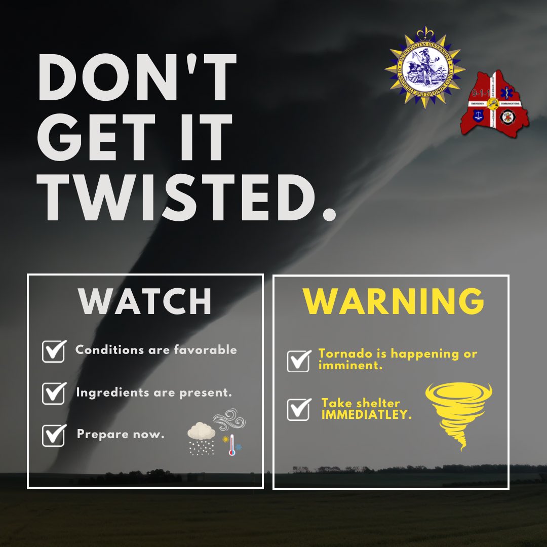
Nashville and Davidson County are included in a Tornado WATCH issued by the National Weather Service Nashville until 5:00 AM CDT, Monday April 28, 2026. A Tornado WATCH means conditions are favorable for tornadoes. Stay #WeatherAware and have a shelter plan ready.

⚠️ #WEATHERAWARE: 3 rounds of strong to severe storms hit Central Alabama tonight through Wednesday. ➡️Round 1 arrives overnight (best chance NW of I-59). ➡️Round 2 Tuesday afternoon/night is the main concern for ALL of Central Alabama — wind, hail, heavy rain, low tornado risk.

youtube.com
YouTube
CBS 42

Behind the rain, there's a low risk for strong-to-severe thunderstorms after 3 p.m. Wednesday. Stay weather aware throughout the day! @wcnc #weatheralert #weatheraware #charlotte #ncwx #scwx


Please be #WeatherAware this evening, Frisco. The @NWSFortWorth has issued a Severe Thunderstorm Watch through 2 a.m. tonight for an area that includes Denton & Collin counties. Sign up for CodeRED alerts at FriscoTexas.gov/CodeRed. @FriscoFFD I @FriscoPD
A severe thunderstorm watch has been issued for parts of Arkansas, Oklahoma and Texas until 2 AM CDT


#SAR 🛟 A @USCG Station Marathon boat crew rescued a capsized kayaker beset by weather near Seven Mile Bridge, Saturday. Before launching your kayak, check local conditions and forecasts. Staying aware keeps your voyage safe and enjoyable. #SafeBoating #WeatherAware

As severe weather season approaches, it's important to understand how tornado warnings are communicated. NWS forecast offices may include Impact Based Warning (IBW) damage tags to convey expected impacts & urgency. #WeatherAware #SevereWeatherPrep

#Metoffice AMBER wind warning ⚠️ issued for #StormDave tonight More details #weatheraware metoffice.gov.uk
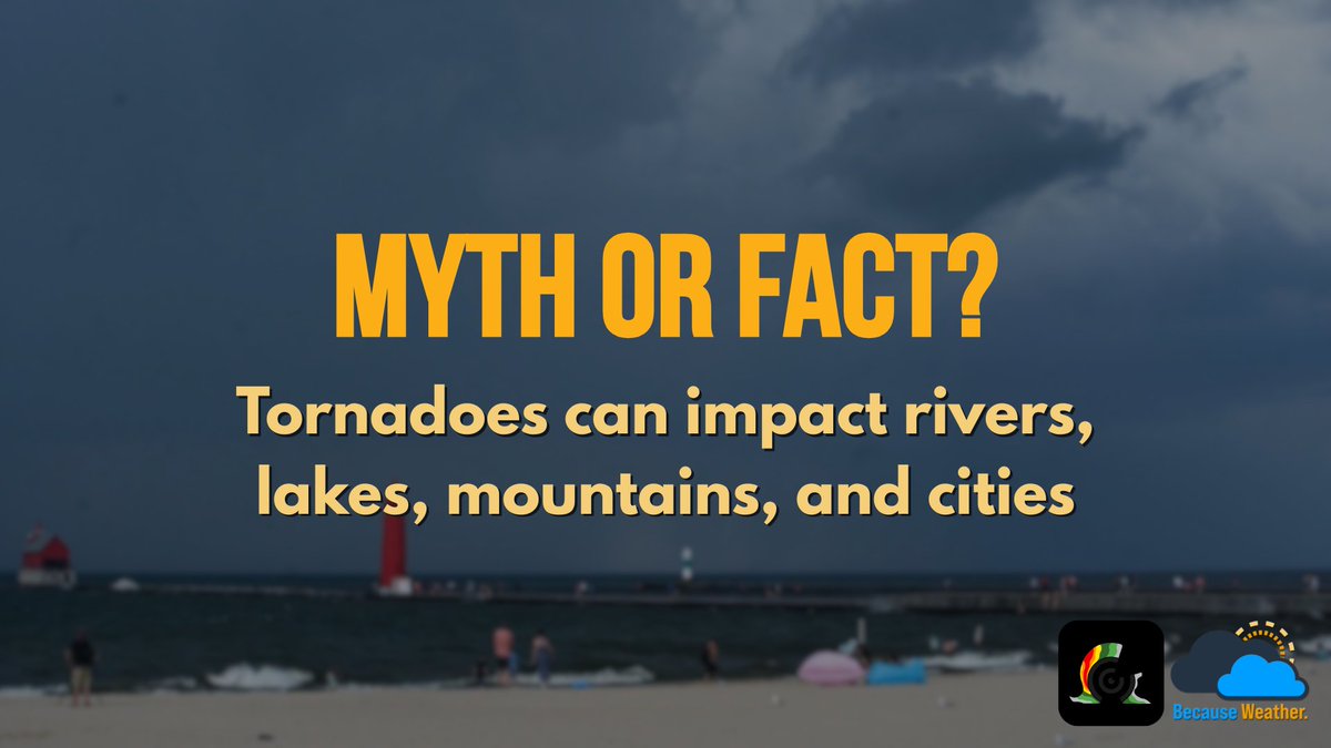
FACT: Tornadoes can impact rivers, lakes, mountains, and cities. No place is “safe” just because you’re outdoors. If you’re hiking, boating, camping, or at the lake, always check the forecast and have a way to get warnings. ⚠️🌪️ #TornadoSafety #OutdoorSafety #WeatherAware
A clear start does not guarantee a smooth finish. Some of the biggest disruptions on the course build in ways that change the round fast. #GolfLife #WeatherAware #PlaySmart
A clear view from the tee box does not always tell the full story. Staying informed before and during your round can help you avoid unexpected changes on the course. #GolfSafety #WeatherAware #BePrepared

#Metoffice yellow warnings ⚠️ for rain and snow issued for Wednesday and Wednesday night #weatheraware metoffice.gov.uk
#Metoffice yellow warnings ⚠️ for #wind issued for Saturday evening through Sunday 85 to 90mph gusts possible #weatheraware metoffice.gov.uk

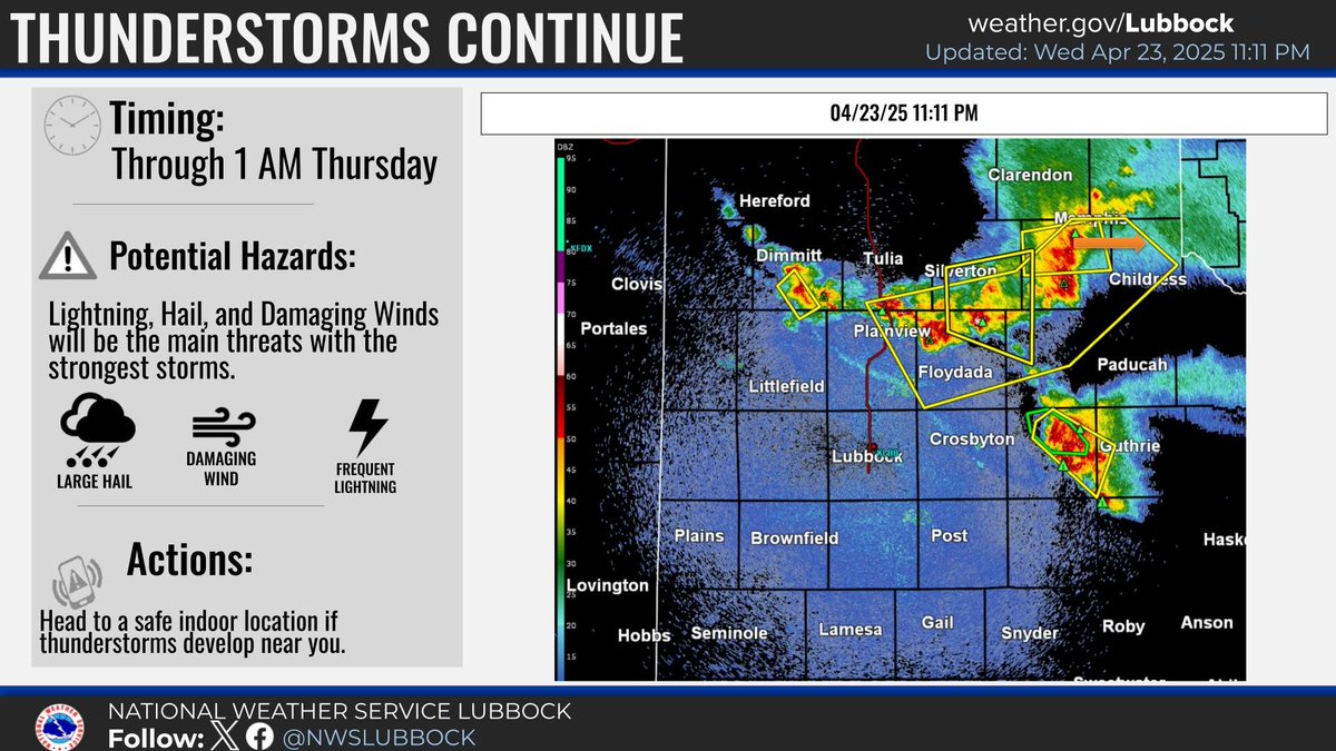
11PM KLBB Radar Update. Storms continue to impact much of the far southern Texas Panhandle and Rolling Plains this evening. Large hail and damaging wind gusts remain the main threat with storms. Have a way to stay #weatheraware! #lubwx #txwx
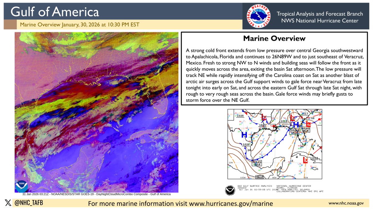
1/30 - Gale Warning is in effect across the SW and Eastern Gulf waters due to an unusually strong cold front moving across the basin. Mariners are urged to use caution. More at hurricanes.gov/marine #marinewx #weatheraware
Shiny, wet-looking pavement in freezing temps can be a hidden sheet of ice. Slow down, avoid sudden turns or hard braking, and give yourself extra space and time whenever conditions are near or below freezing. ❄️🚗 #WinterSafety #DriveSafe #WeatherAware

Impact-based severe thunderstorm warnings highlight the expected threat level, from damaging winds & larger hail to considerable or destructive impacts. Pay attention to the wording of your warnings, stronger tags mean higher danger. #SevereWeatherSafety #WeatherAware

Desert temps can swing 30-40°F after sunset. 🌡️ Don’t let a warm afternoon fool you; pack layers, a proper sleeping bag, and a solid sleep system. 🌙 #DesertCamping #CampSmart #WeatherAware
#Metoffice yellow warning ⚠️ for rain and snow issued for N Ireland 0400 to 2000 tomorrow #weatheraware metoffice.gov.uk

A Tornado Watch is in effect for much of the state today/tonight. Damaging winds, hail/heavy rain are other key threats as severe weather really sets in Tuesday, Wednesday and Friday this week. Know the risks for your area and any driving or outdoor plans! 👇🏼 #WeatherAware


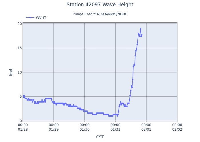
1/31 - Strong gale-force winds and very rough seas are affecting the eastern Gulf waters. A buoy recently reported 19 ft seas in the SE Gulf. More at hurricanes.gov/marine #marinewx #weatheraware @databuoycenter
1/29 - High pressure dominates much of the SW N Atlantic, supporting fresh to locally strong E winds and locally rough seas S of 23N and W of the front. Also, fresh to strong NW winds & rough seas follow the front N of 29N. More at hurricanes.gov/marine #marinewx #weatheraware

2/20 – A plume of Saharan dust continues moving west across the tropical Atlantic, suppressing shower and t’storm activity and reducing visibility. Latest marine forecast: hurricanes.gov/marine #marinewx #Saharandust #weatheraware
⚠️ Heads Up, Mid-South! Sunday afternoon/evening looks dicey. A line of thunderstorms will move through with a cold front, bringing damaging winds and the potential for quick spin-up tornadoes. Stay tuned for updates and stay #WeatherAware! ⛈️
Something went wrong.
Something went wrong.
United States Trends
- 1. May the 4th N/A
- 2. Star Wars N/A
- 3. John Sterling N/A
- 4. Chelsea N/A
- 5. Cole Palmer N/A
- 6. Joao Pedro N/A
- 7. Rick Barnes N/A
- 8. Yankees N/A
- 9. Jedi N/A
- 10. Juke Harris N/A
- 11. Strait of Hormuz N/A
- 12. #MondayMotivation N/A
- 13. Good Monday N/A
- 14. #May4th N/A
- 15. #BudGreatDelivery N/A
- 16. CNBC N/A
- 17. Teacher Appreciation Week N/A
- 18. Rogue One N/A
- 19. Derry N/A
- 20. NextNRG Inc N/A