
Todd Kimberlain
@Todd_Met
SFWMD Met. Tweets are my own, not my employer's.
คุณอาจชื่นชอบ


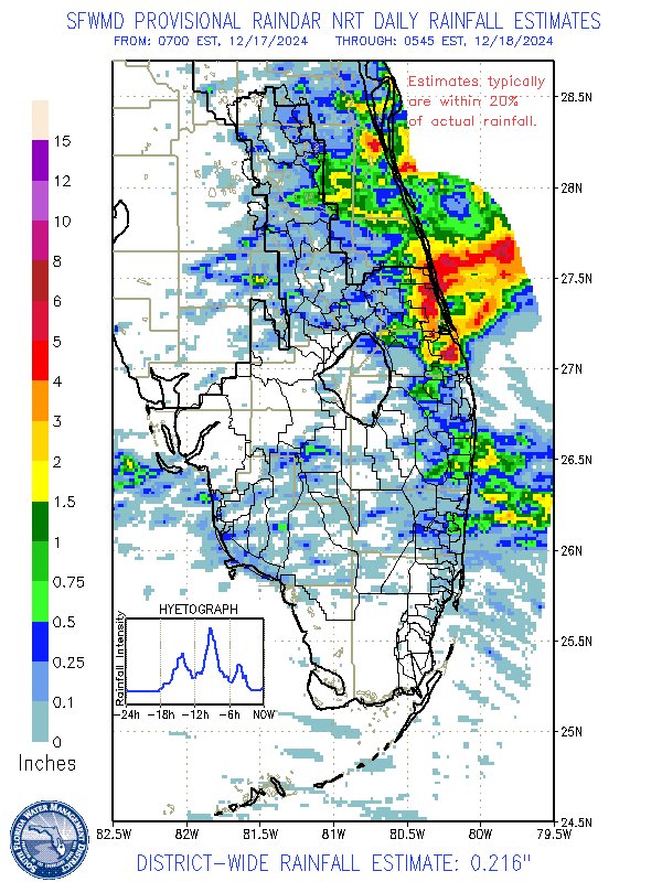
Deep moisture from the Bahamas/Caribbean, instability fueled by warm Gulf Stream waters, 'lift' from a southern jet stream disturbance, & mesoscale processes combine to unleash torrential rains along FL's Treasure Coast. Radar: 8.5" in Martin Co., 6-7" in St. Lucie! #flwx @SFWMD

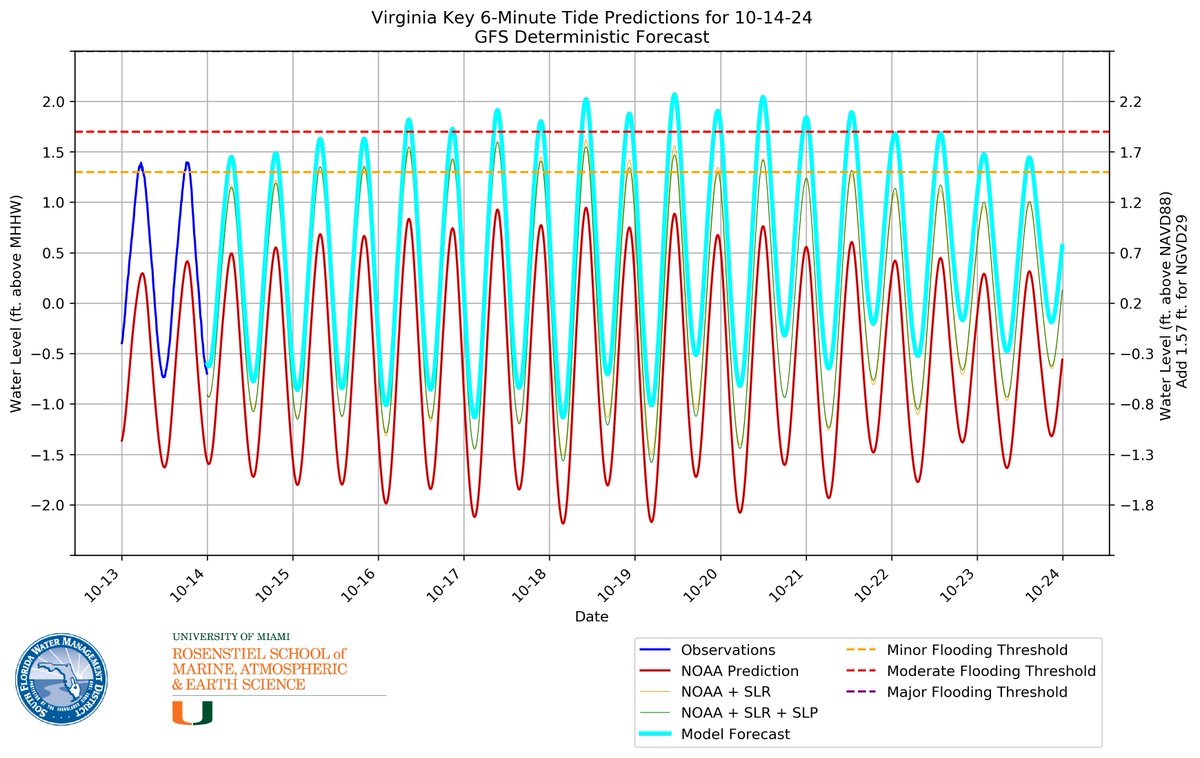
As expected, the highest astronomical tide of the year is coming up on Oct 18. Tide forecasts show that #Miami could experience record-breaking high tides from the 16th-23rd, so be prepared for a week of tidal flooding around every high tide. #KingTides …trict-resiliency-sfwmd.hub.arcgis.com/apps/855a2167a…
![BMcNoldy's tweet image. #Tide predictions for 2024 in southeast #Florida feature a primary peak centered on October 18 near a full moon. Note that tide predictions are only astronomical/climatological in nature, and do not account for actual weather or ocean conditions which can be significant. [1/3]](https://pbs.twimg.com/media/GC2Vm3PbUAACw_2.png)
![BMcNoldy's tweet image. #Tide predictions for 2024 in southeast #Florida feature a primary peak centered on October 18 near a full moon. Note that tide predictions are only astronomical/climatological in nature, and do not account for actual weather or ocean conditions which can be significant. [1/3]](https://pbs.twimg.com/media/GC2Vn9ra0AAJlft.png)

I don’t think I’ve ever seen a tornado this large in #swfl from a tropical system. This was taken earlier in the day south of Clewiston by Cade Mullens #swfl #Milton

Live with @JimCantore in Port Charlotte, FL where the surge is rising from #HurricaneMilton
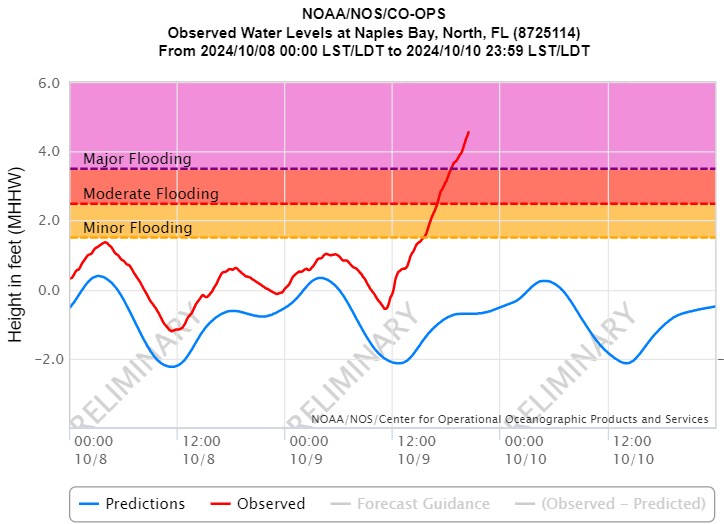
4.56 ft. MHHW at Naples Bay and still climbing. 2nd highest water level in Naples after Hurricane Ian 28 Sept '22, when the water level peaked of 6.2 ft. MHHW. #Milton

Wow! My cousin sent this to me by a neighbor of his of the tornado that struck Wellington, FL from earlier today. Incredible speed & power that tornado possessed. #HurricaneMilton #flwx
PBI tying their all-time record high of 99 degrees for the month of May around 1 pm! #flwx
Virginia Key (near #Miami) just set a record high tide for the second consecutive day on Monday. It's also the 44th daily record high tide during 2023 so far. That means that new record high water levels have been set on 13% of the days this year! [1/2]
![BMcNoldy's tweet image. Virginia Key (near #Miami) just set a record high tide for the second consecutive day on Monday. It's also the 44th daily record high tide during 2023 so far. That means that new record high water levels have been set on 13% of the days this year! [1/2]](https://pbs.twimg.com/media/F_8hHZXbsAAjK-2.jpg)
Virginia Key, near Miami, experienced a record-high tide for the date on Thursday (1.65' MHHW). This was forecast perfectly by our tide forecast model five days in advance. The next 5-6 days will be contenders for new records too, especially Sunday-Monday. bmcnoldy.earth.miami.edu/tide/
Tide forecasts are escalating for the #Miami area. Water levels could reach the highest since Nov 10, 2022 when Hurricane Nicole's passage coincided with an already-high #KingTide. As of now, the forecasts peak on Monday... about 5 inches above the moderate flooding threshold.

Satellite loop of Hurricane Otis explosively intensifying from a tropical storm to a category 5 hurricane in less than 24 hours, courtesy of the GOES-18 satellite mesoscale floater:

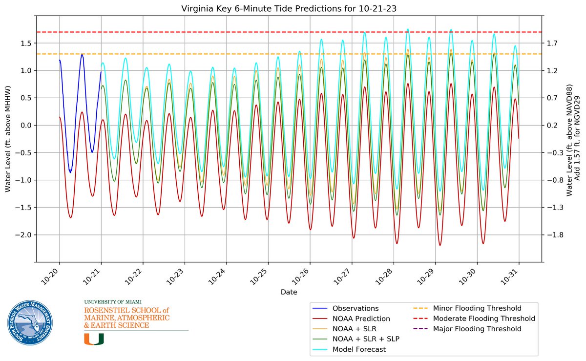
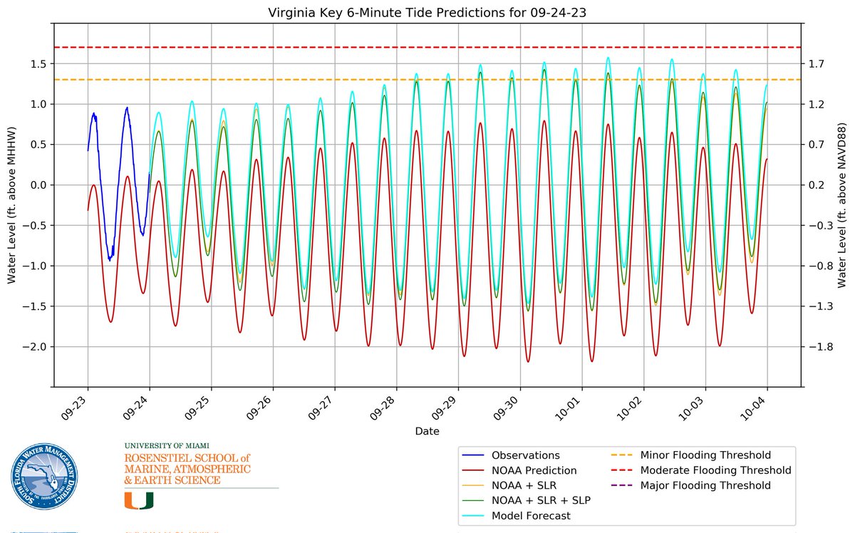
With Lake Worth flooding today, I expect all four sites in south Florida to see some level of tidal flooding tomorrow, including Virginia Key. Flooding will likely be a daily occurrence through most of next week with the highest tides happening around 10-2 & 10-3. @BMcNoldy
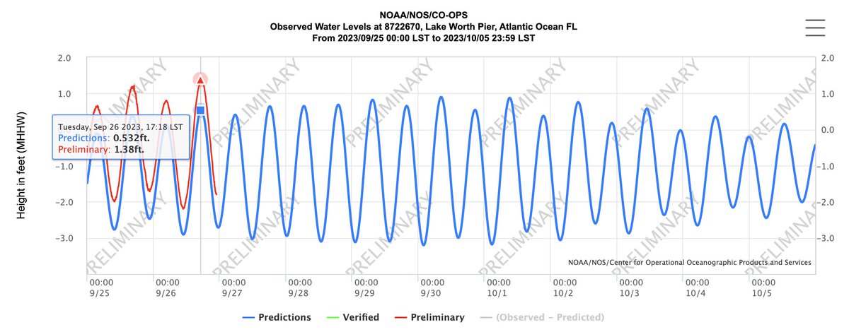
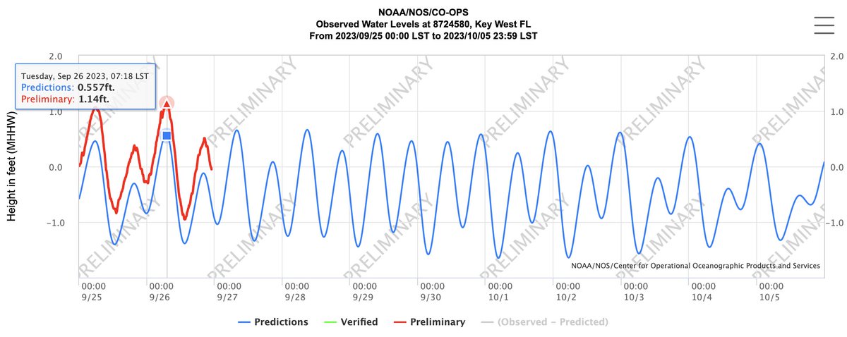
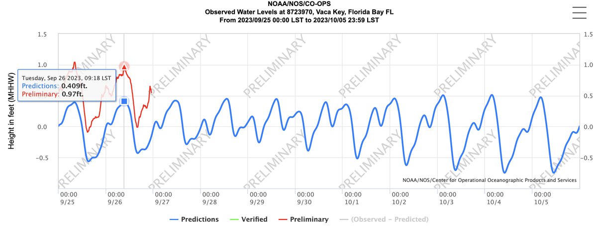
Water levels exceeded the minor flooding threshold at Lake Worth Pier, Key West, and Vaca Key today. This is the first day of flooding for Lake Worth and Key West, and the sixth consecutive day of flooding for Vaca Key. More info can be found below: bmcnoldy.earth.miami.edu/tide/
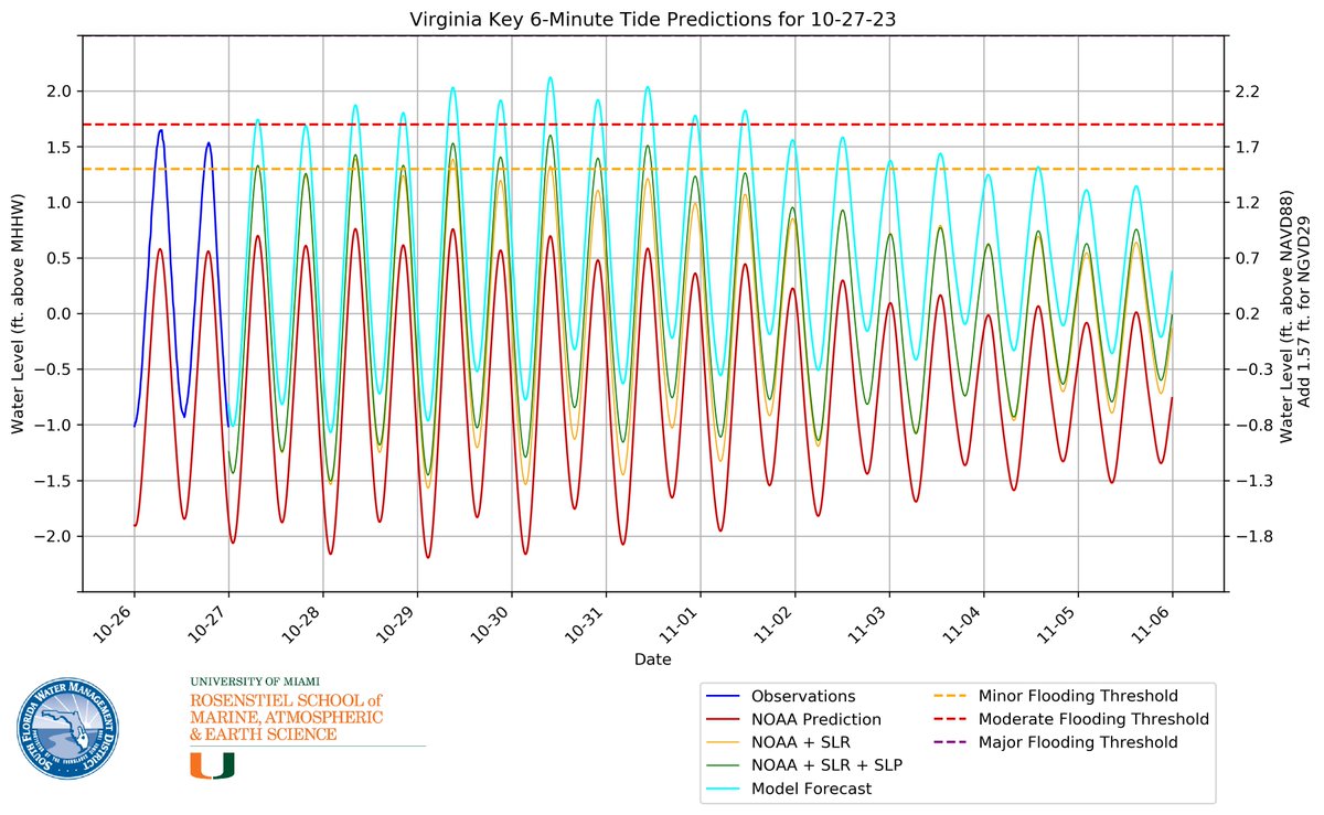
The #Miami area now has at least six days of potential tidal flooding near every high tide beginning on the 28th. bmcnoldy.earth.miami.edu/tide/ #KingTide
🌦️ It's #WorldMeteorologicalDay, and we’re recognizing our @SFWMD meteorologists who provide weather forecasts that guide important water management decisions. Check out the real-time weather tools that our team uses to keep an eye on the sky. Visit SFWMD.gov/Weather
Key West with just 2% of normal rainfall YTD. Last measurable rainfall 12 February. Amazing. Luckily, could get some relief this coming week. #flwx


United States เทรนด์
- 1. Washington Post N/A
- 2. WaPo N/A
- 3. #NGWSD N/A
- 4. Bezos N/A
- 5. The Post N/A
- 6. Maxine Waters N/A
- 7. Scott Bessent N/A
- 8. Ryan Routh N/A
- 9. #NSD26 N/A
- 10. #WorldCancerDay N/A
- 11. Mickey Lolich N/A
- 12. Frisco N/A
- 13. National Signing Day N/A
- 14. #ForeverWithYouTH N/A
- 15. Meeks N/A
- 16. taehyun N/A
- 17. Secretary Bessent N/A
- 18. #텬냥이생일_모아가_축하한다고냥 N/A
- 19. Frank Reich N/A
- 20. Eala N/A


Something went wrong.
Something went wrong.