
StormTrackerSacher
@TrackerSacker
Northeast Tennessee coverage on short and long range weather, 7-Day forecasts for the Tri-Cities, model discussion, etc. Snow is the best kind of weather.
Bạn có thể thích


Every winter we’re all on baited breath to see if we can get into phase 8. Looks like we will. Time will tell.


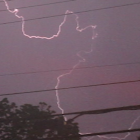
⚡️Thundersnow?❄️ Notice the light blue streaks on the HRRR model? That’s lightning. Some of the snow squalls on Monday *might* produce “thundersnow”. Even though this setup results in spotty light accumulations at best in the valley, sometimes you can get briefly heavy rates and…

Arctic Cold Snap: Besides the accumulating snow expected, low temperatures and wind chills will be very cold tonight and Monday night. Gusty winds the next couple of nights paired with much colder than normal temperatures, will create really cold wind chills.


⚠️Winter Weather Advisory now in effect for Johnson-Southeast Greene-Unicoi-Southeast Carter-Southeast Monroe Wise-Russell-Washington VA- Including the cities of Limestone Cove, Erwin, Wise, Citico, Norton, Castlewood, Shady Valley, Laurel Bloomery, Coker Creek, Appalachia, Dye,…

Winter Storm Warning now in effect for Cocke Smoky Mountains-Blount Smoky Mountains Sevier Smoky Mountains including the cities of Cades Cove, Hartford, Elkmont, and Gatlinburg from 7:00 PM this evening to 7:00 AM Tuesday. The Winter Storm Watch has upgraded. Heavy and…

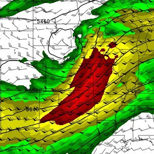
No one can agree on politics nowadays, but we all finally found unity in the realization that the Euro is king and the GFS is off its rocker

EURO taking the dub with this one. Not even close
Latest snowfall probabilities from our friends at the National Weather Service in Morristown for the upcoming event through Tuesday morning: (Concerning the Tri-Cities) • Probability of > a dusting: 65-90% chance • Probability of >1”: 25-50% chance • Probability of >2”:…


If I ever feel like a failure I’ll just think of the GFS
If you’re a nature photographer in the Southern Appalachian region, get your cameras ready. There is a slight chance we are about to get some very picturesque scenes if we can net even a light coating of snow on this leftover fall foliage; an opportunity we do not get very often.


GSMNP Highway 411 and Newfound Gap Road will close at 6 PM tomorrow due to winter weather.
🌬️Arctic Blast & Snow Headlines for Tri-Cities • 🌡️ Temperatures: Falling into the 30s Sunday night and never recovering with and eventual drop into the 20s by later Monday and settling in the low 20s Monday night and Tuesday morning. Highs only 35-40° on Tuesday. Wind chills…


United States Xu hướng
- 1. Colts 36.3K posts
- 2. Falcons 22.8K posts
- 3. Daniel Jones 8,628 posts
- 4. Jonathan Taylor 7,212 posts
- 5. Penix 7,866 posts
- 6. Bijan 5,339 posts
- 7. Mooney 3,257 posts
- 8. Drake London 3,818 posts
- 9. Tyler Warren 1,302 posts
- 10. Konate 16.1K posts
- 11. Max B 17.7K posts
- 12. Raheem Morris 1,811 posts
- 13. Liverpool 159K posts
- 14. #ForTheShoe 2,556 posts
- 15. Zac Robinson N/A
- 16. Pitts 3,979 posts
- 17. $LMT $450.50 Lockheed F-35 N/A
- 18. Tyler Allgeier 1,468 posts
- 19. $APDN $0.20 Applied DNA N/A
- 20. $SENS $0.70 Senseonics CGM N/A
Bạn có thể thích
-
 Mitch West
@SCweather_wx -
 Gerald Mengel
@GMengel -
 Will Ciccone
@weatherwilly -
 Norman Smith
@Norman_Wx -
 Henry Burton
@HenryWX -
 Spot On Weather
@eulermatthew4 -
 BGWX
BGWX
@BradyBGWX -
 Jim Bishop
@StormgasmJim -
 Convective Chronicles
@ConvChronicles -
 Brendan Weathers
@WeathersWX -
 Mark Margavage
@MeteoMark -
 Nathan Renner
@Nathan_Renner_ -
 IndyWx.com
@indywx -
 Empire Weather
@empirewx -
 Seth Monteith ⛈
@SethMonteith150
Something went wrong.
Something went wrong.