IsaacWxObserver
@IsaacWxObserver
Weather observer in Rockland county. I focus on weather in and around NYC
Bạn có thể thích


Widespread temperatures in the 20s outside of NYC and the coast this morning. The first widespread freeze for the region.

Really hard to hate this progression for December if you are a snow lover. Lots of high latitude blocking and plentiful cold air in the Lower 48


Tomorrow's cover: Zohran Mamdani wins 2025 NYC mayoral election trib.al/akdfChF

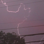
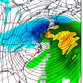
That front is going to arrive like a freight train

Recent runs have toned down the extreme winds. Not surprised really, but nonetheless peak wing gusts of 50mph are still likely.

Fronts like tomorrow night I call freight train FROPAs! You’ll notice when the front comes through because it’s like a freight train. It will get your attention…or in this case with it approaching near midnight, it will wake you up. Instant wind shift from SW to NW with gusts…

Recent runs have toned down the extreme winds. Not surprised really, but nonetheless peak wing gusts of 50mph are still likely.
Winds tomorrow night are going to be no joke. Winds gusts up to 60mph in the NYC metro


Sure going to be interesting having a communist mayor in NYC.

Winds die down tonight only to ramp up again tomorrow afternoon with potentially damaging gusts at night, likely peaking around midnight and staying blustery into Thursday.

I have some doubts on the higher-end winds for tomorrow night, but I would still suggest securing anything that might be outside tomorrow night after the cold front passage. I expect 30 to 60 mph wind gusts for a short time between 10 PM and 2 AM tomorrow night.
Its going to be a cold week next week. After that we likely get warm for a while though.

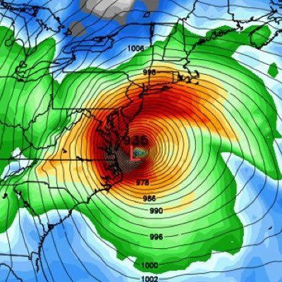
A strong cold frontal passage Wednesday evening will bring potential for damaging wind gusts Wednesday evening into early Thursday morning. The front also brings potential for a line of scattered to broken showers in the evening, which may contain strong to severe wind gusts.

[High Wind Watch] Damaging wind gusts are possible Wednesday night into early Thursday morning. West winds 20-30 mph with gusts up to 60 mph may occur, bringing potential of downed trees and power outages. A high wind watch is in effect from 9pm Wednesday through 8 am Thursday.
![NWSNewYorkNY's tweet image. [High Wind Watch] Damaging wind gusts are possible Wednesday night into early Thursday morning. West winds 20-30 mph with gusts up to 60 mph may occur, bringing potential of downed trees and power outages. A high wind watch is in effect from 9pm Wednesday through 8 am Thursday.](https://pbs.twimg.com/media/G47nEC5WoAAsr24.jpg)
![NWSNewYorkNY's tweet image. [High Wind Watch] Damaging wind gusts are possible Wednesday night into early Thursday morning. West winds 20-30 mph with gusts up to 60 mph may occur, bringing potential of downed trees and power outages. A high wind watch is in effect from 9pm Wednesday through 8 am Thursday.](https://pbs.twimg.com/media/G47nMVIXsAAaLe5.jpg)
Winds tomorrow night are going to be no joke. Winds gusts up to 60mph in the NYC metro

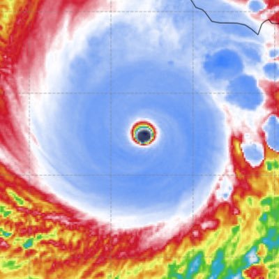
❗️High wind gusts up to 40-60 mph is possible Tomorrow into Thursday Morning. Isolated-Scattered power outages are expected! Several models are depicting a seasonal windstorm to occur middle in the week. 🕐TIMING... Tuesday for the Northern Plains and great lakes region.…


Many things are lining up for a fast start to winter this year in the East-Central US For ex: being in a La Niña w/ a slower-moving and more amplified MJO (due in part to the easterly QBO) makes a subsequent -NAO/AO more likely Fig from Lee et al (2019): agupubs.onlinelibrary.wiley.com/doi/full/10.10…

Haven't had much time to comment on this lately due to #Melissa, but meteorological winter looks poised to get off to a fast start over the Eastern US this year Favorable West Pac-W Hem MJO orbit coupled w/ La Nina heavily favors a +PNA/-EPO/-NAO type pattern to open up December


United States Xu hướng
- 1. Penn State 22.1K posts
- 2. Mendoza 18.9K posts
- 3. Gus Johnson 6,226 posts
- 4. #iufb 3,998 posts
- 5. $SSHIB 1,287 posts
- 6. Omar Cooper 8,985 posts
- 7. Sayin 65.5K posts
- 8. Estevao 29.4K posts
- 9. Sunderland 151K posts
- 10. #UFCVegas111 3,768 posts
- 11. Iowa 18.7K posts
- 12. Texas Tech 13.2K posts
- 13. Jim Knowles N/A
- 14. James Franklin 8,100 posts
- 15. Happy Valley 1,818 posts
- 16. Oregon 32.8K posts
- 17. Arsenal 252K posts
- 18. Neto 25.5K posts
- 19. Garnacho 22.4K posts
- 20. WHAT A CATCH 11K posts
Bạn có thể thích
-
 Will Ciccone
@weatherwilly -
 Michael Barletta
@MikeBWeather -
 Boston Weather Consulting (by Owen)
@BostonWxConsult -
 BGWX
BGWX
@BradyBGWX -
 Stephen Eckhardt ☀️
@seckhardt -
 #LOCKITIN
@lockingitin -
 Matthew Ferreira | MassachusettsWx
@MassachusettsWx -
 StormchaserJS
@stormchaserjs -
 Logan Giles
@LoganGilesWx -
 Mike Mostwill
@MikeMostwill -
 Jay
Jay
@JayB7897 -
 Maines Abominable SnowBART
@MESNOWman1 -
 Cristopher Cace
@ccace_wx -
 🦄NPCJoey🦄
@npcjoeyy -
 Ralphs Weather OBS
@WeatherNut27
Something went wrong.
Something went wrong.