
Dr. Levi Cowan
@TropicalTidbits
Owner/developer of https://tropicaltidbits.com. PhD in meteorology from FSU. Opinions are mine alone. Follow for expert, factual, no-hype hurricane analysis
قد يعجبك


Aircraft reconnaissance data from the @53rdWRS hurricane hunters shows that Tropical Storm Jerry has max winds of around 65 mph, with the strongest winds confined north and east of the storm center. Jerry remains significantly sheared/tilted and is likely to struggle to intensify…


Tropical Storm #Jerry appears to already be vertically misaligned due to westerly shear, with the low level circulation partially exposed west of the main convective mass. This structure may delay intensification into a hurricane until/if the vortex becomes less tilted.
🌀 Tropical Storm #Jerry has formed east of the Caribbean Sea, and will pass close to the Leeward Islands on Thursday night and Friday morning. 🌀 Jerry does not yet have a well-organized inner core, but is now producing max winds of 45 mph and is forecast to intensify over the…


🌀 A tropical disturbance (Invest #95L) in the central Atlantic is becoming better organized today, with expanding deep convection and apparent mid-level rotation, though a well-defined surface circulation may not yet exist. 🌀 95L will track west-northwestward toward the…


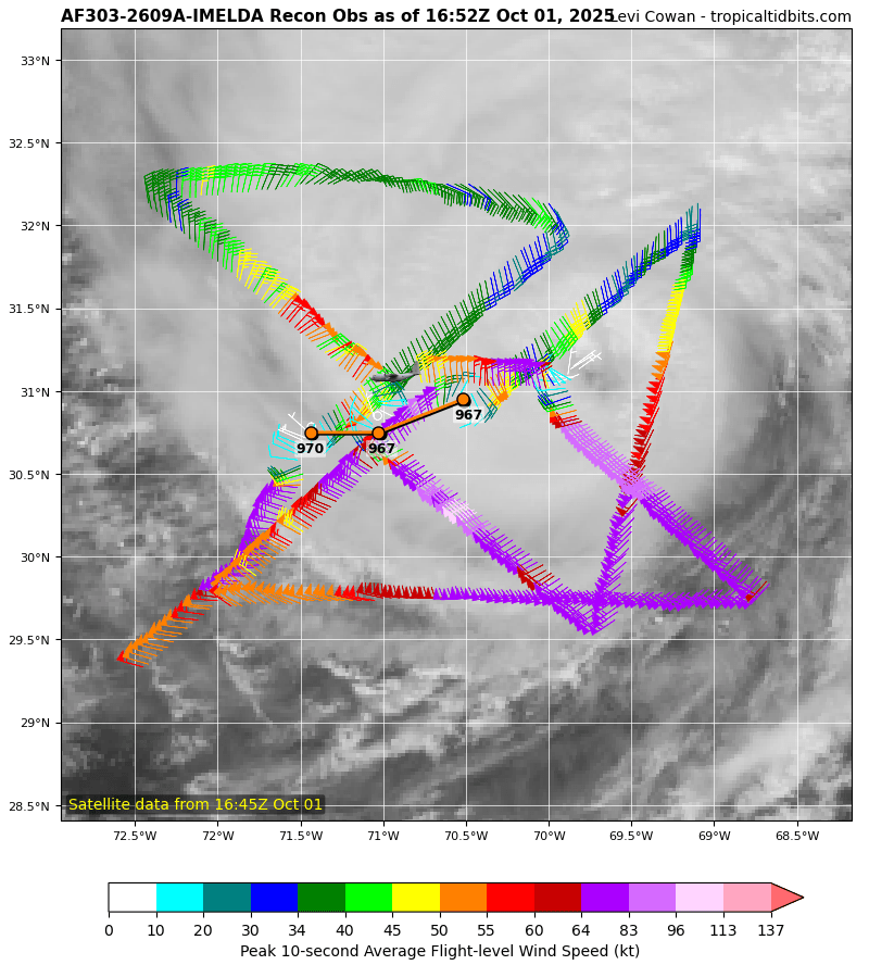
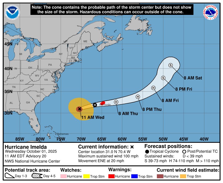
Hurricane #Imelda has strengthened, with aerial reconnaissance data from @53rdWRS indicating max winds are around 100 mph. Imelda is accelerating east-northeastward toward #Bermuda, where a hurricane warning is in place. Imelda is expected to pass near or over the island tonight.…
Tropical Storm #Imelda is intensifying steadily this morning as an inner convective core consolidates and becomes more compact, despite some southerly shear which continues to tilt the vortex slightly. Aircraft data from the @53rdWRS indicates max winds have increased to about 60…


#TD9 has strengthened into a tropical storm and is now officially named #Imelda. Aircraft reconnaissance data from @NOAA_HurrHunter shows a better defined core wind field, but the inner max wind ring remains asymmetric and rather wide at 50-80 NM radius, indicating that Imelda's…


Tropical Depression Nine (#TD9) continues to gradually organize north of Cuba, and may strengthen into Tropical Storm #Imelda later today. The slow motion northward into the #Bahamas has resulted in a further shift southeastward in the track forecast, with the eastward turn…


Still no development of a compact inner core wind ring with #TD9 in aerial reconnaissance data from @NOAA_HurrHunter, so the trend of gradual—not rapid—organization continues tonight.

🌀 Saturday video update on newly-formed Tropical Depression Nine (#TD9; likely to be named #Imelda later) and Major Hurricane #Humberto 🌀 TD9 is expected to bring hazardous weather to the #Bahamas and possibly eastern #Florida, #Georgia, #SouthCarolina, and #NorthCarolina.…
Some good news so far today: The GFS and ECMWF have trended farther south (closer to Cuba) with #TD9's position over the last 24-36 hours (see animations below), resulting in slower tracks northward, leading both models to flip to the "no US landfall" scenario, and rather turn…

The @NHC_Atlantic has initiated advisories on Invest #94L as "Potential Tropical Cyclone Nine (#PTC9)". This means 94L is not yet a tropical cyclone, but is expected to become one soon and threaten land areas. If/when 94L becomes a tropical storm, it would be named #Imelda.…


🌀 Friday (long!) video update on Hurricane #Humberto and Invest #94L (likely to develop and be named #Imelda) 🌀 While uncertainty in this complex forecast remains elevated, risk of life-threatening impacts to the southeastern US continues to increase. Follow your local @NWS…
🌀 Thursday video update on Tropical Storm #Humberto and Invest #94L (would be named #Imelda if it develops). 🌀 These two storms are raising risks to the #TurksAndCaicos, #Bahamas, southeastern US, and #Bermuda this weekend and next week, though uncertainty remains high. Have a…
🌀 Wednesday video update on two tropical systems expected to develop and bring impacts to the southwestern Atlantic region this week and next week:
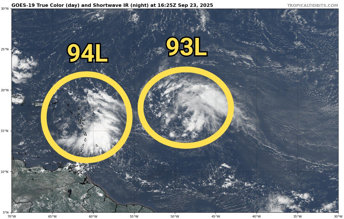
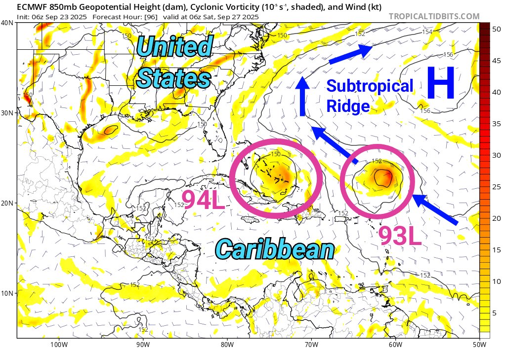
🌀 A pair of tropical waves (#93L and #94L) in the central Atlantic have a chance to develop into tropical cyclones this week as they travel north of the Caribbean. 🌀 Environmental conditions may be suboptimal for the eastern wave (93L) late week as it interacts with an…

Tropical Storm #Gabrielle is entering a more favorable environment for intensification as vertical shear relaxes, resulting in development of a more compact wind field and an increase in max winds to 60 mph. Gabrielle is forecast to become a hurricane as it recurves east of…

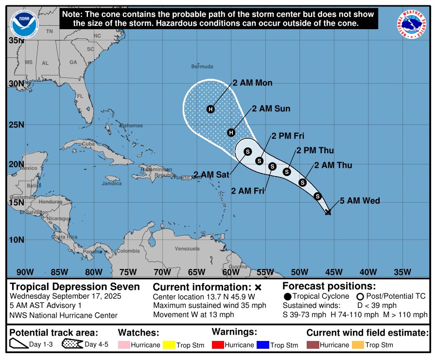
The National Hurricane Center has initiated advisories on Tropical Depression Seven (#TD7) over the central Atlantic. The system is poorly organized due to its elongated structure, which is entangled with some upper-level troughing and dry air to the northwest, and is struggling…
A broad tropical wave in the central Atlantic has been labeled "Invest #92L" by the @NHC_Atlantic and is being monitored for tropical development this week. Current conditions and the prevalence of deep thunderstorm activity around 92L favor consolidation over the next couple of…


United States الاتجاهات
- 1. Auburn 43.3K posts
- 2. Brewers 60.8K posts
- 3. Georgia 66.3K posts
- 4. Cubs 53.9K posts
- 5. Kirby 22.9K posts
- 6. Michigan 61.6K posts
- 7. Arizona 40.6K posts
- 8. Hugh Freeze 3,095 posts
- 9. #GoDawgs 5,438 posts
- 10. Kyle Tucker 3,069 posts
- 11. Boots 49.5K posts
- 12. #BYUFOOTBALL N/A
- 13. Amy Poehler 3,537 posts
- 14. #ThisIsMyCrew 3,172 posts
- 15. Gilligan 5,413 posts
- 16. Tina Fey 2,574 posts
- 17. Jackson Arnold 2,148 posts
- 18. #MalimCendari3D 3,365 posts
- 19. Sherrone Moore 2,034 posts
- 20. Utah 22.8K posts
قد يعجبك
-
 National Hurricane Center
@NHC_Atlantic -
 NOAA Aircraft Operations Center
@NOAA_HurrHunter -
 Philip Klotzbach
@philklotzbach -
 NWS Weather Prediction Center
@NWSWPC -
 Hurricane Hunters
@53rdWRS -
 National Hurricane Center
@NWSNHC -
 NWS Storm Prediction Center
@NWSSPC -
 Dr. Rick Knabb
@DrRickKnabb -
 Mike's Weather Page
@tropicalupdate -
 NHC_TAFB
@NHC_TAFB -
 Jim Cantore
@JimCantore -
 Michael Lowry
@MichaelRLowry -
 Eric Webb
@webberweather -
 WeatherBELL
@weatherbell -
 Mike Ventrice
@MJVentrice
Something went wrong.
Something went wrong.