#ptc9 resultados da pesquisa


🟡#PTC9🟡 ⏺️ Se pronostica un fortalecimiento signficativo del #PTC9 durante los próximos días. Actualmente, tiene vientos máximos sostenidos de 35 mph. ▶️ Se espera que el Potencial Ciclón Número #Nine se convierta en un Huracán Mayor el jueves. Se ha emitido una nueva:…


Really cool new tool: AI Super Ensemble.. I ran Pangu-Weather and FourCastNet initialized with each GEFS member and produced a plot of tracks for #PTC9.. also produced probabilistic forecasts from this super-ensemble. Obviously, this is an experimental product.


🔔🔄#PTC9 - Nuevo Video 📹 #PTC9 está cerca de ser la tormenta tropical #Helene. Se pronostica que pasará muy cerca o sobre la Península de Yucatán y Cuba el miércoles. #Helene podría fortalecerse rápidamente en un huracán de categoría mayor antes de llegar a Florida. Las…
First NHC official forecast for #Helene when it was labeled Potential Tropical Cyclone 9 (#PTC9) (left) vs observed (via @cyclonicwx) (right). In general, I'm not sure how you can do much better than that.


Ok so on to #PTC9 which will become #imelda over the weekend. Guidance continues us down a indecisive path in terms of whether its coming ashore or going out to sea. Regardless it gets tangled up with the current front over the southeast and that will aid in VERY HEAVY RAIN…


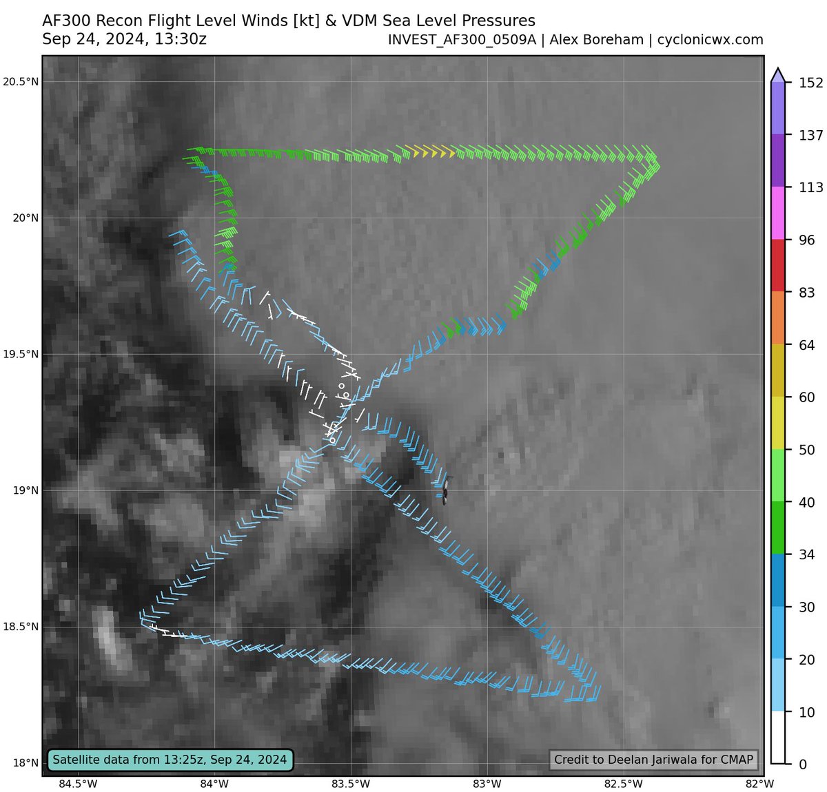
Potential Tropical Cyclone 9 (#PTC9) has likely strengthened into a bonafide tropical storm (#Helene) this morning. A closed, well-defined low-level vortex exists near the SW edge of the convection, while peak flight level winds ~45-50 kt, SFMR ~40 kt, and dropsonde derived SLP…


The @NHC_Atlantic has initiated advisories on Invest #94L as "Potential Tropical Cyclone Nine (#PTC9)". This means 94L is not yet a tropical cyclone, but is expected to become one soon and threaten land areas. If/when 94L becomes a tropical storm, it would be named #Imelda.…


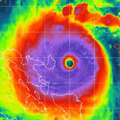
Latest satellite view of Potential Tropical Cyclone Nine. #PTC9 This large area of disorganized showers and thunderstorms over eastern Cuba and Hispaniola could develop into a tropical depression as it moves across the Bahamas over the next day or so.

We now have #PTC9 or otherwise future #Imedla. This is going to be a slow mover, and rainfall will be its calling card. Right now the highest flood eask will be east of I-77, but lots of uncertainty on the track, so please stay tuned for updates all weekend long. #cltwx #ncwx…

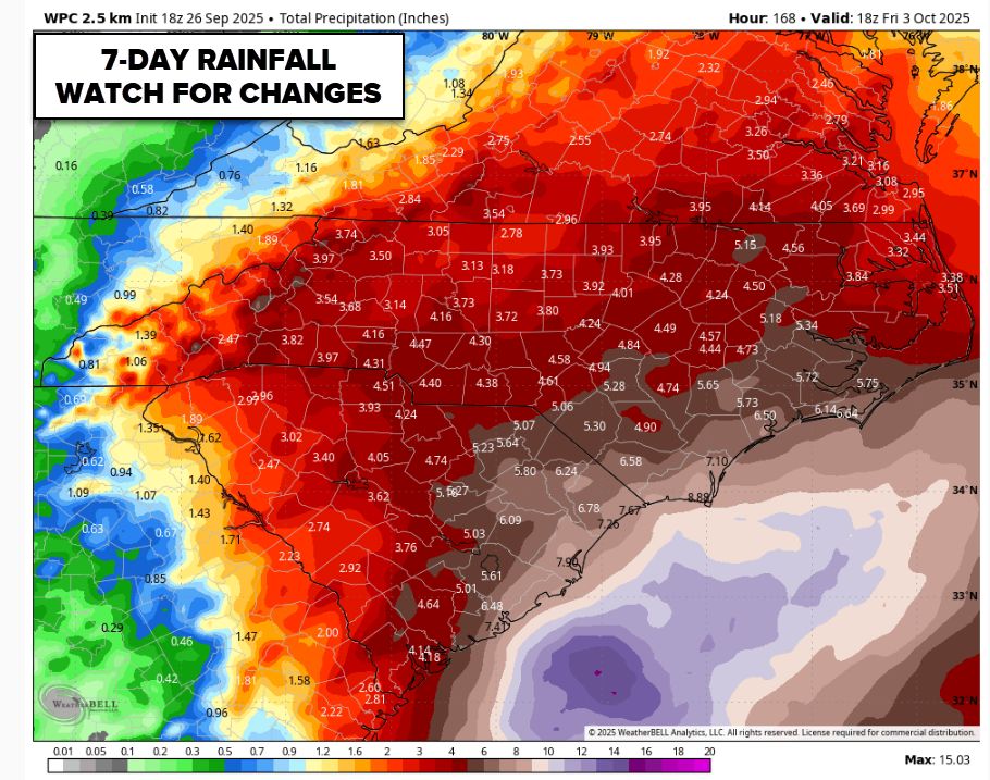
The overnight guidance trend continued with #PTC9 future #Imelda. Most guidance has the system stalling offshore and then being picked up by #Humberto and taken out to sea. There is still a chance it stalls then drifts west, either way, rainfall is going to be heavy for the…


That's a trend you don't want to see... #Ptc9's forecast has shifted more to the west, closer to #Florida. Of course, we will keep you updated on the potential impacts! #wx #flwx #imelda #hurricane


TOP 3 IMPACTS: #PTC9 will become better organized as it lifts northward towards the Lowcountry, bringing a risk of heavy rainfall, strong wind gusts and coastal impacts. Fluctuations in the forecast can, and will, occur as forecast models begin to align. #Tropics #SCWX


#PTC9 has been battling shear and is still asymmetric as a result. Should be a TS soon, though. We'll see if this short-term struggle affects the peak intensity in the Gulf - the hurricane models are still very aggressive, as are some global models like GFS/AIFS. Once this starts…


18z Google Deep Mind ensembles. A handful make an official landfall, while the others are either just off the coast or make the escape to the east. #PTC9


We're @JimCantore official folks!! #imelda #ptc9 #td9 #94L


Well… looks like another one bites the dust. #PTC9 is probably going out to see; it will not latch onto Cuba and is moving way too slow while #Humberto, a Cat 5 hurricane, is going to suck this weak system right out to sea. The east coast of Florida might see some wind and rain,…


Global Warming 🤡🤣🤣 Debunked Long Ago UN IPCC servers hacked, revealed falsified GW Quantitative DATA 🤣🤣 Pro Global Warming PhD dissertations were peer reviewed by SAME agenda minded Governing Panel 🤣🤣 #TD9 #PTC9 #ptc09 THREAD⬇️ x.com/DayWalker378/s…
Global Warming Human Induced #Climate means, Satanic Scientists Want Humans EXTERMINATED from Earth✅ Global Warming, DEBUNKED as Agenda Based Falsified Data, LONG AGO. UN IPCC Server Breach Exposed 10K PhD Clowns were Falsifying Data, for Project Funds cambridge.org/core/journals/…

State of emergency for North Carolina ahead of #PTC9!

I have declared a State of Emergency to enable the State Emergency Response Team to mobilize resources and prepare for potential impacts of hazardous weather, including Tropical Depression 9 or future Imelda. The forecast remains uncertain, so it’s important that North…

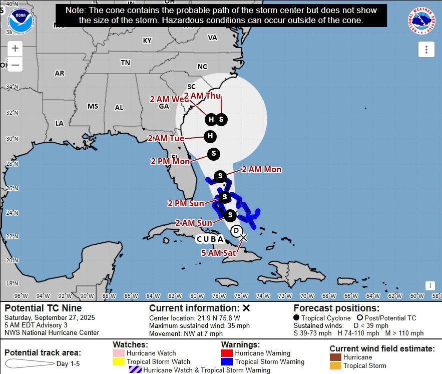
#TrackingTheTropics #PTC9 has become Tropical Depression 9 near the Bahamas. It is forecast to become Tropical Storm #Imelda soon and strengthen into a Category 1 hurricane by Tuesday. The forecast remains the same with a now turn to the right or east and keeps it away from…


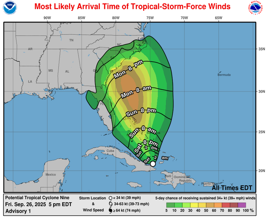
According to the NHC 11 AM update - An Air Force Reserve Hurricane Hunter mission is planned for later today. Current #PTC9 stats: - Maximum Sustained Winds: 35 mph - Minimum Central Pressure: 1005 mb

#PTC9 is starting to organize and get that "look" of being a centralized circulation/depression. Should start to see more development today. Interestingly enough, the NHC is banking a bit more on Hurricane #Humberto to pull on #PTC9 (soon to be "Imelda") to the east once it nears…


#PTC9 becomes a Tropical Depression #Nine this morning. #TD9 will bring Tropical Storm conditions to the Bahamas over the weekend and into early next week, while tropical storm conditions are possible for portions of Florida's east coast starting later this weekend. Confidence in…


11 am EDT - System becomes Tropical Depression Nine just north of eastern Cuba. Tropical Storm Watch issued for portions of the east coast of Florida. Here are the Key Messages. Visit hurricanes.gov for updates.

#Humberto blows up to a CAT 4 (145 mph winds). Recurve west of Bermuda seems to be the solution. #94L has been tagged #PTC9. TS warnings up for Bahamas. Models suggesting a close approach to SE U.S. coast, then getting tugged out to sea by Humberto.


I will be in the Port Canaveral area Monday for the arrival of winds from #PTC9 I will likely be in contact with Cocoa PD as well. #FLwx #wxtwitter.

MLB issues Tropical Storm Watch (Coastal Indian River, Coastal Martin, Coastal St. Lucie, Coastal Volusia, Mainland Northern Brevard, Mainland Southern Brevard, Northern Brevard Barrier Islands, Southern Brevard Barrier Islands [FL]) until further not... mesonet.agron.iastate.edu/vtec/f/2025-O-…
![iembot_mlb's tweet image. MLB issues Tropical Storm Watch (Coastal Indian River, Coastal Martin, Coastal St. Lucie, Coastal Volusia, Mainland Northern Brevard, Mainland Southern Brevard, Northern Brevard Barrier Islands, Southern Brevard Barrier Islands [FL]) until further not... mesonet.agron.iastate.edu/vtec/f/2025-O-…](https://pbs.twimg.com/media/G13JrcmWkAERHth.png)
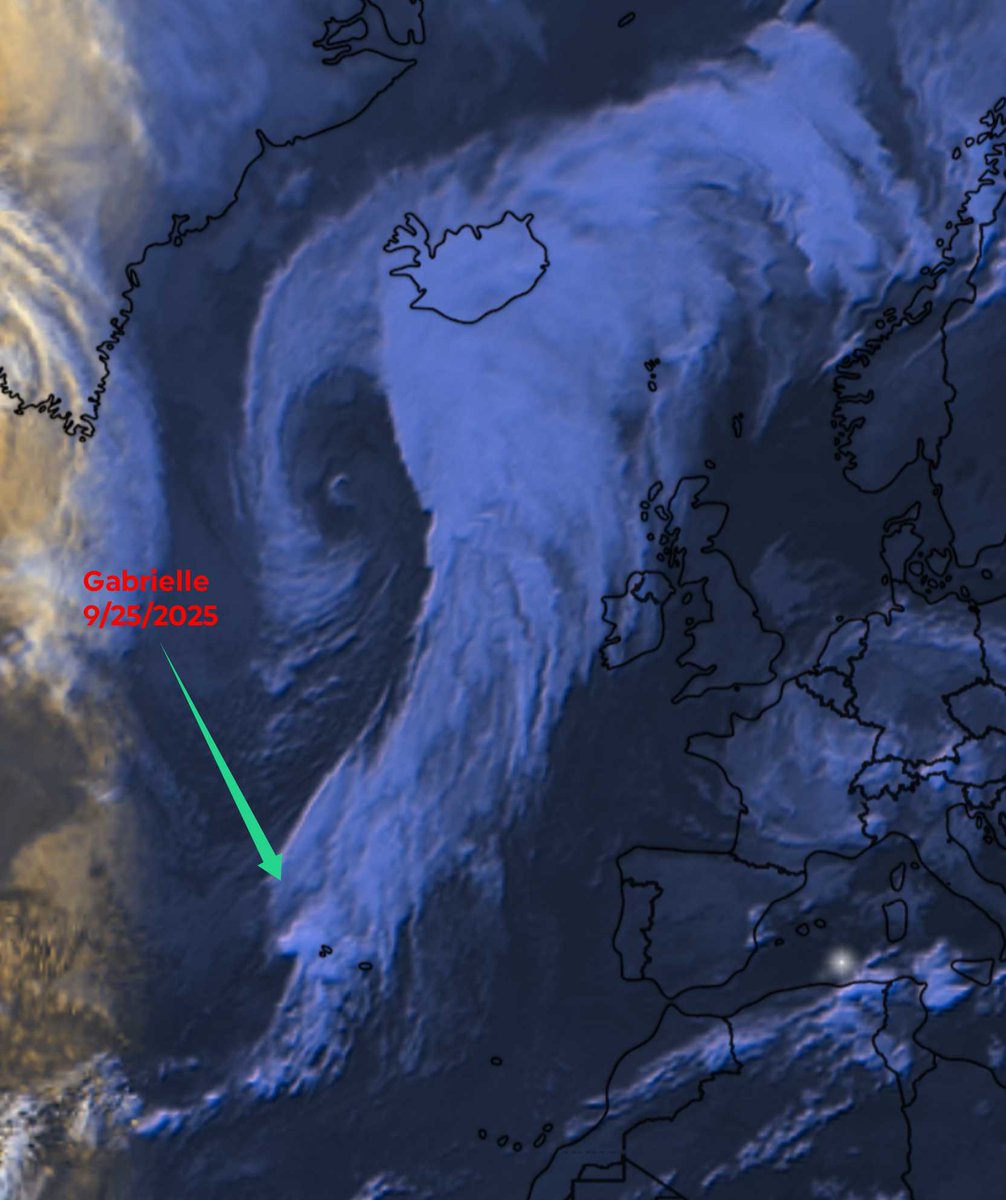
Daily Reminder, NHC is Wrong 90% of the time Here's a recent one, #Gabrielle was projected to be a Hurricane well into Friday. Wrong! But, already dissipated & absorbed into an existing Sting Jet, Thursday morning Then slam into Portugal as a Depression. Wrong! #PTC9 #ptc09


#PTC9 will make a close pass to the southeast US but thankfully all indications are the system will head out to sea with no direct landfall. ift.tt/BPL9sZD


🟡#PTC9🟡 ⏺️ Se pronostica un fortalecimiento signficativo del #PTC9 durante los próximos días. Actualmente, tiene vientos máximos sostenidos de 35 mph. ▶️ Se espera que el Potencial Ciclón Número #Nine se convierta en un Huracán Mayor el jueves. Se ha emitido una nueva:…
#PTC9 A las 11:00 AM EDT empezarán los boletines del Potencial Ciclón Tropical Número 9

NHC will initiate advisories on Potential Tropical Cyclone Nine, located over the northwestern Caribbean Sea, at 1100 AM EDT (1500 UTC).

#PTC9 hasn't changed much overnight, BUT that's going to change today. All hurricane models show a powerful #Helene on Thursday at least Cat 4, making landfall. Hurricane watches are up on the west coast. TODAY is the day to PREPARE, go over your plans and evacuations, and PLEASE…


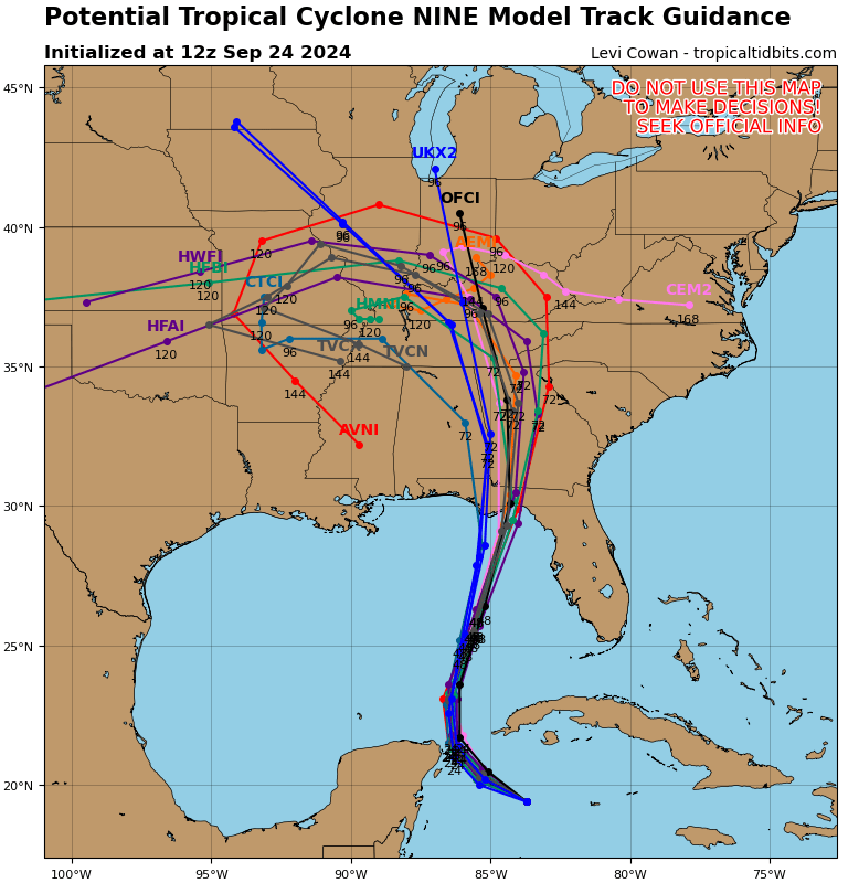
NHC issues first track cone for #PTC9. NHC has stated their top end wind speeds is not as aggressive as some of the guidance. Regardless, once an inner core is established, nothing will stop a very likely rapid intensification. So by this time Wednesday, we are looking at a whole…


9/24 5AM EDT: The potential for life-threatening storm surge from #PTC9 is increasing along the coast of the Florida Panhandle and the Florida west gulf coast. Residents should ensure they have their hurricane plan in place, and also follow advice given by local officials.


Westerly shear over #PTC9 on water vapor channel is evident. Said shear is likely aided by Hurricane John in the east Pacific and once that comes ashore tomorrow morning it will start to slow over pending #Helene PTC9 has very good ventilation with ridging aloft and once the…


11pm EDT Mon 23rd Sep: Here are the latest key messages for Potential Tropical Cyclone Nine #PTC9 which is forecast to strengthen significantly the next few days. Hurricane Watches & Storm Surge Watches will likely be issued on Tuesday. Latest forecast: hurricanes.gov/#Nine

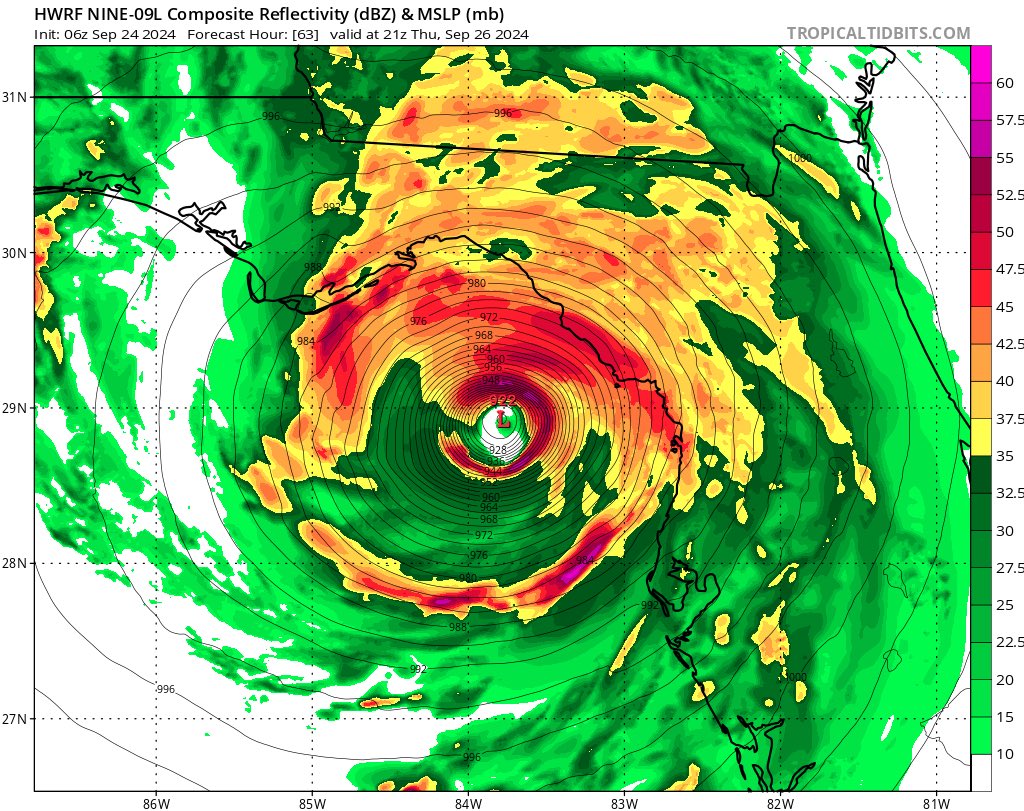
6z HAFS-A and HAFS-b are hot off the press and are stronger than their 0z runs. Landfall location is similar. HAFS-B is approaching 900mb pressure again. #flwx #PTC9


First NHC official forecast for #Helene when it was labeled Potential Tropical Cyclone 9 (#PTC9) (left) vs observed (via @cyclonicwx) (right). In general, I'm not sure how you can do much better than that.
12z spaghetti models remaining consistent with their track. Effects will be felt along the panhandle, big bend and FL west coast. #flwx #PTC9
6z HWRF is very similar to 0z run. Maybe slightly north and east. End result is the same. Major hurricane into the Big Bend. Impacts all along the west coast. #flwx #PTC9

With the potential for heavy rains and storm surge associated with #PTC9, FDOT crews in NW Florida are running field operation tests on high-volume water pumps in anticipation for statewide deployment. #ReadytoServe #OneFDOT

Potential Tropical Cyclone 9 (#PTC9) has likely strengthened into a bonafide tropical storm (#Helene) this morning. A closed, well-defined low-level vortex exists near the SW edge of the convection, while peak flight level winds ~45-50 kt, SFMR ~40 kt, and dropsonde derived SLP…

More important than the seriousness of future-#Helene actually bombing out below 900 mbar is how favorable the 12z Hurricane models apparently think the Eastern Gulf will be. If #PTC9 consolidates an organized core in the Caribbean, the likelihood of rapid intensification over…


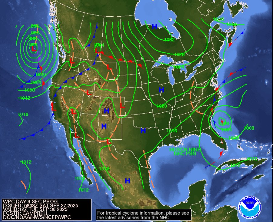
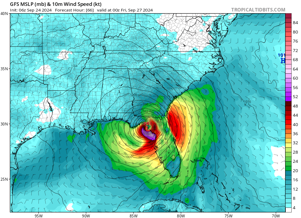
Potential Tropical Cyclone Nine (#PTC9) is now being explicitly forecast to become a 115+ mph, Category 3 Major Hurricane by landfall near Carrabelle, #Florida on Thursday afternoon.

Really cool new tool: AI Super Ensemble.. I ran Pangu-Weather and FourCastNet initialized with each GEFS member and produced a plot of tracks for #PTC9.. also produced probabilistic forecasts from this super-ensemble. Obviously, this is an experimental product.
Something went wrong.
Something went wrong.
United States Trends
- 1. Good Sunday 58.4K posts
- 2. Troy Franklin N/A
- 3. #sundayvibes 5,368 posts
- 4. #AskFFT N/A
- 5. #AskBetr N/A
- 6. Brownlee N/A
- 7. Mason Taylor N/A
- 8. Muhammad Qasim 17.9K posts
- 9. #NationalFarmersDay N/A
- 10. Miary Zo 2,034 posts
- 11. #DENvsNYJ N/A
- 12. Discussing Web3 N/A
- 13. KenPom N/A
- 14. Wordle 1,576 X N/A
- 15. Jermaine Johnson N/A
- 16. Trump's FBI 14.3K posts
- 17. Biden FBI 21.8K posts
- 18. The CDC 33.1K posts
- 19. Blessed Sunday 19K posts
- 20. Bourne 1,494 posts