Bureau of Land Management- Nevada
@blmnv
Between the glowing neon lights of Las Vegas and the High Sierras, we manage nearly 48 million acres of public land in Nevada. #MyPublicLands
You might like


Fire restrictions decrease on southern Nevada public lands on 11/09. Other restrictions remain in effect and vary across agencies. Current BLM restrictions: fireworks, explosives, firearms, & more. All details at blm.gov/announcement/f… #FireYear2024 #WildfirePrevention

It’s #FirePreventionWeek and we want to thank YOU for all you do to prevent wildfires! So, here’s a video of the ways you practice fire safety, but with a little western twist! 🤠 Remember, #OnlyYou can prevent wildfires (but also #ItTakesAllOfUs 😅🔥) BLM & @Maverik video
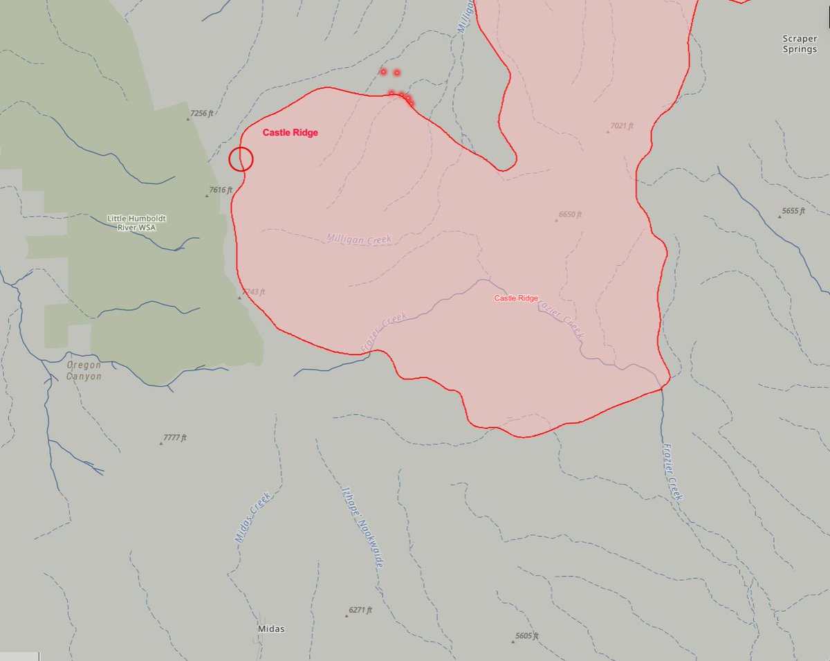
#CastleRidgeFire is ¼ mile north of Midas, Elko Co. & 25,762 acres, 20% contained. Forward progress stopped overnight. Get real-time updates and track movement on the Fire Map: NevadaFireInfo.org More updates: inciweb.wildfire.gov/incident-infor… #FireYear2024

We’re hiring several fire positions across Nevada. See usajobs.gov/Search/Results… We’re happy to chat, answer questions, & give guidance on applying. Click “Talk to a Recruiter” at NevadaFireInfo.org/careers #WeAreBlmFire #NotYourOrdinaryJob #FireJob

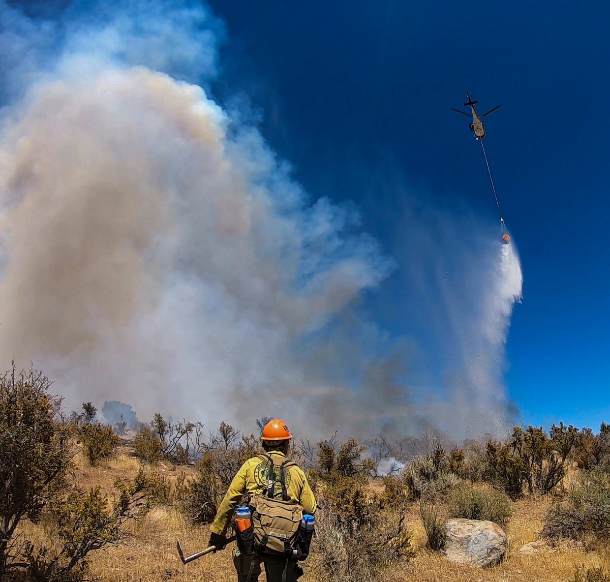
#CastleRidgeFire, north of Midas, Elko Co. Estimate 24,078 acres, 10% contained. For latest updates: NevadaFireInfo.org - Follow fire on Nev. Fire Map & Nev. Fire Camera: Midas Peak (see 📷) and inciweb.wildfire.gov/incident-infor…


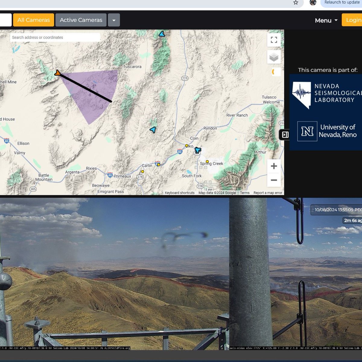
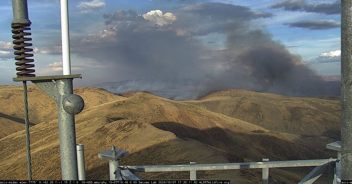
#CastleRidgeFire is 4 miles north of Midas, NV, and as of this morning, was estimated to be 5,700 acres and 10% contained. Wildfire camera: alertnevada.live/cam-console/12… Updates: inciweb.wildfire.gov/incident-infor… 📷: Midas Peak camera, 5:18 PM

Are you traveling this weekend? Take a packing break and learn how to #SparkSafety, not wildfires with your vehicle and trailer. More at NevadaFireInfo.org/prevention #OnlyYou #RecreateResponsibly BLM Video
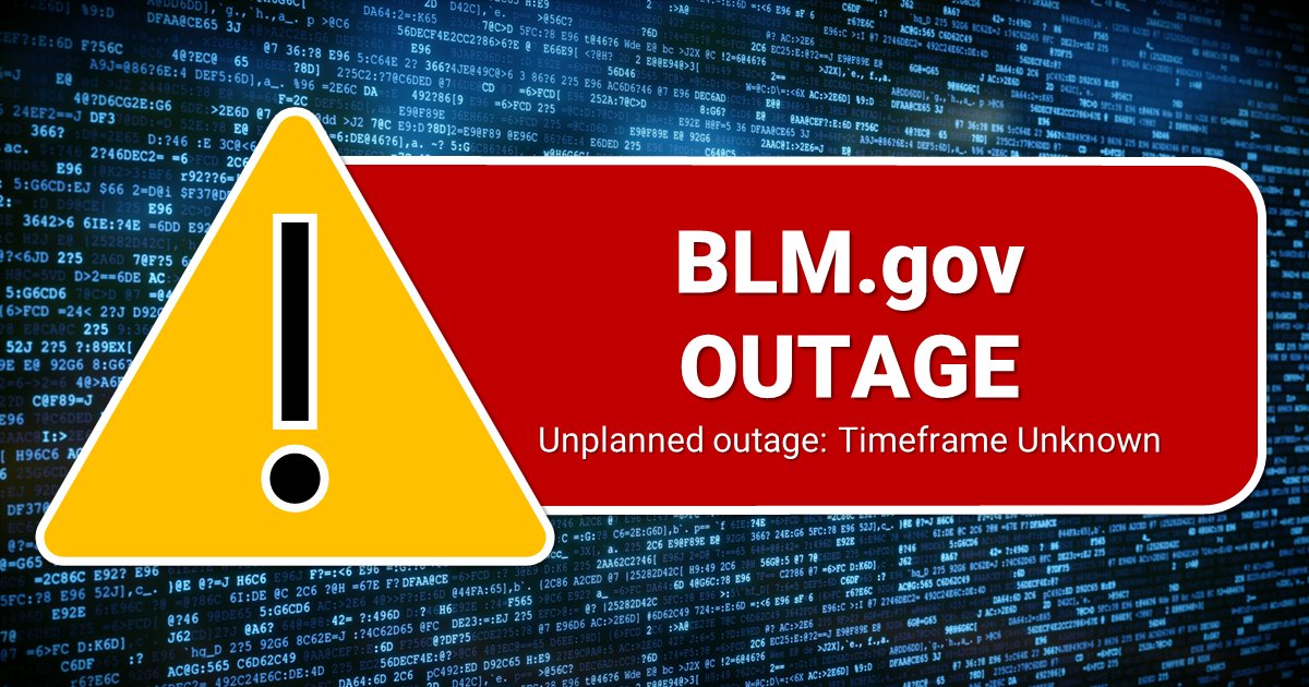
We’re aware that our website (BLM.gov) is unavailable. This is an unexpected outage and we’re working on resolution of the issue as quickly as we can. We apologize for this inconvenience and thank you for your patience during this time.
Douglas Co. #SpringValleyFire is 100% contained, approx. 264 acres. Crews continue to extinguish burning materials on fire control lines. Please visit NevadaFireInfo.org for map of active NV fires, fire cameras, & fire restrictions (most of NV under Stage 1). #FireYear2024

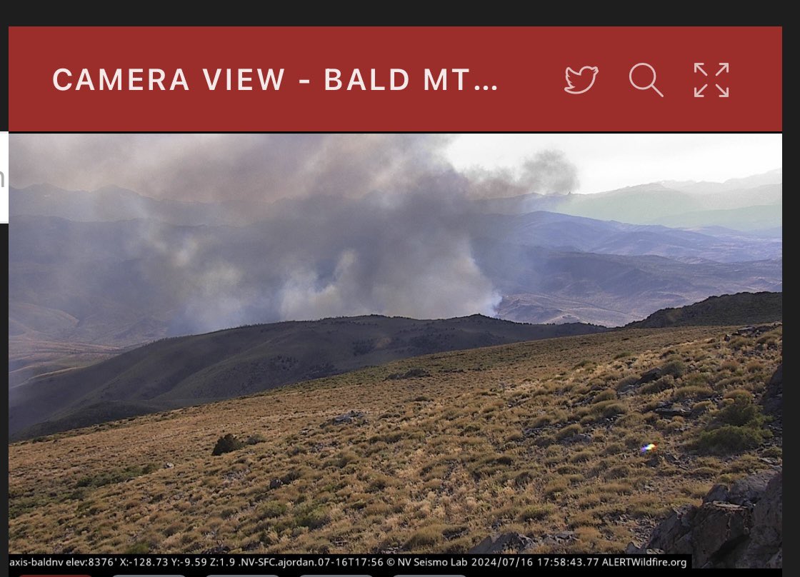
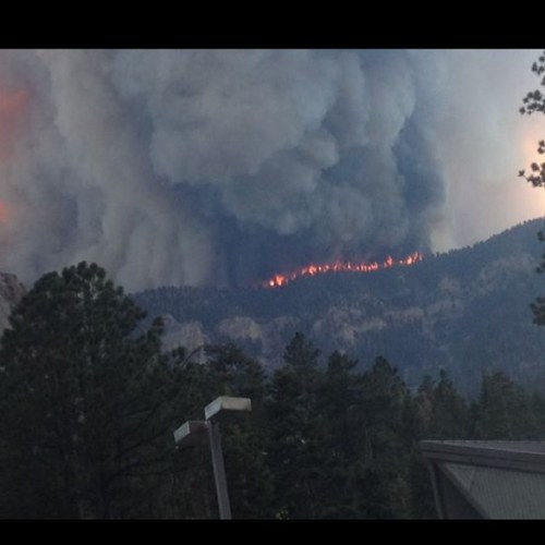
#SpringFire, Douglas Co update: 264 acres, 20% contained. Hwy 395 open. Today's forecast: rising temps, gusty afternoon wind. More info: Evacs. & closures @CountyofDouglas Fire Map & cameras NevadaFireInfo.org 📸: Fire weather & outlook gacc.nifc.gov/gbcc #FireYear2024

Evacuations for TRE are lifted and residents may now return to their homes. The TRE Community Center evacuation center is now closed. The evacuation for Double Springs is still in place. U.S. 395 is still closed in both directions at Leviathan Mine Road and State Route 208.
#SpringFire on Hwy 395. Structures threatened. See @CountyofDouglas evacuations. Estimated 100 acres, 0% contained, & rapid rate of spread. BLM, East Fork Fire Protection District, & more responding. Live fire map and wildfire cameras at NevadaFireInfo.org

Today we pause in honor of Jacob O’Malley and Will Hawkins from the @blmnv Winnemucca District. Both lost their lives on July 10, 2016 in a single-vehicle accident on Hwy 140, 37 miles north of Winnemucca. These young men will forever be in our hearts and #NeverForgotten.


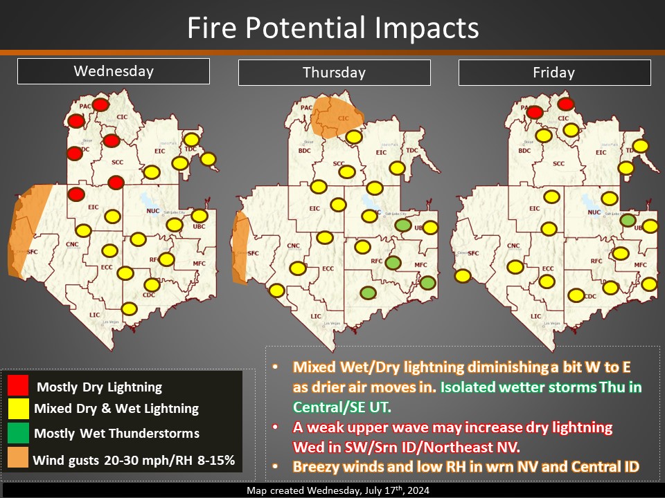
Wildfire risk increases in Nev. Expect record high temps., dry conditions, & winds Wed. - Fri. 85% of wildfires are caused by people, many by accident. See how to prevent wildfire & current restrictions at NevadaFireInfo.org 📷: gacc.nifc.gov/gbcc

Update on 2 fires that ignited 07/07 #WilderFire: Winnemucca District, 16,830 acres & 30% contained at 9:30 AM today inciweb.wildfire.gov/incident-infor… #NorthCreekFire: Ely District, 1,100 acres & 0% contained on Sun, 4:25 PM inciweb.wildfire.gov/incident-infor… See fire map at NevadaFireInfo.org


Public lands belong to you & future generations. BLM's mission is to maintain their health & unique natural & cultural resources. But you play a role! Wildfire activity is becoming more extreme. #RecreateResponsibly to help protect YOUR public lands. Visit NevadaFireInfo.org
BLM Nevada reports 37 fires, 937 acres burned last week. Overall, more than 85% of wildfires are caused by humans. Know current fire restrictions for your area and places you travel. Visit NevadaFireInfo.org 📸: Water drop on Virgin River Fire in Clark County, June 27.
Happy (early) #4thofJuly! Fireworks are always prohibited on public lands managed by BLM-Nevada. Be safe and remember, #OnlyYou can prevent wildfires! Learn more about fire safety and current restrictions at NevadaFireInfo.org

Stage 1 Fire Restrictions begin 06/28 in northwestern & central NV on open fires, operating vehicles on dried vegetation, and more. Details and affected locations: ow.ly/LLP050Ss7xQ. Complete list of NV fire restrictions: nevadafireinfo.org

BLM-NV reports 24 fires, 415 acres burned last week. Weather, dry fuels, & human activity are increasing wildfire risk in Nevada. See fire restrictions in your area & before traveling. They affect campfires, barbecues, fireworks, & more. NevadaFireInfo.org/Restrictions 📷 BLM, 2020 fire


United States Trends
- 1. Cooper Flagg 7,833 posts
- 2. Randle 2,306 posts
- 3. The Spurs 12.4K posts
- 4. Mavs 5,381 posts
- 5. #WWENXT 10.2K posts
- 6. #Pluribus 11.4K posts
- 7. Keldon Johnson N/A
- 8. Cam Johnson N/A
- 9. #LGRW 2,472 posts
- 10. Peyton Watson N/A
- 11. Rosetta Stone N/A
- 12. Bruins 5,097 posts
- 13. GO SPURS GO N/A
- 14. Christmas Eve 163K posts
- 15. Maxey 2,678 posts
- 16. Embiid 3,234 posts
- 17. UNLV 1,778 posts
- 18. Yellow 59.4K posts
- 19. #KennedyCenterHonors N/A
- 20. PWat N/A
You might like
-
 Bureau of Land Management - National
@BLMNational -
 Reno Police
@RenoPolice -
 Nevada DOT
@nevadadot -
 Bureau of Land Management California
@BLMca -
 City of Reno
@CityofReno -
 Bureau of Land Management Colorado
@BLM_CO -
 Humboldt Toiyabe NF
@HumboldtToiyabe -
 City of Sparks, NV
@cityofsparks -
 BLM Utah
@BLMUtah -
 Travel Nevada
@TravelNevada -
 BLMWyoming
@BLMWyoming -
 KOLO8
KOLO8
@KOLO8 -
 Bureau of Land Management - Arizona
@BLMArizona -
 Bureau of Land Management Idaho
@BLMIdaho -
 BLM Montana/Dakotas
@BLM_MTDKs
Something went wrong.
Something went wrong.