
Marc Jansen
@selectoid
Application developer (geospatial applications)
You might like


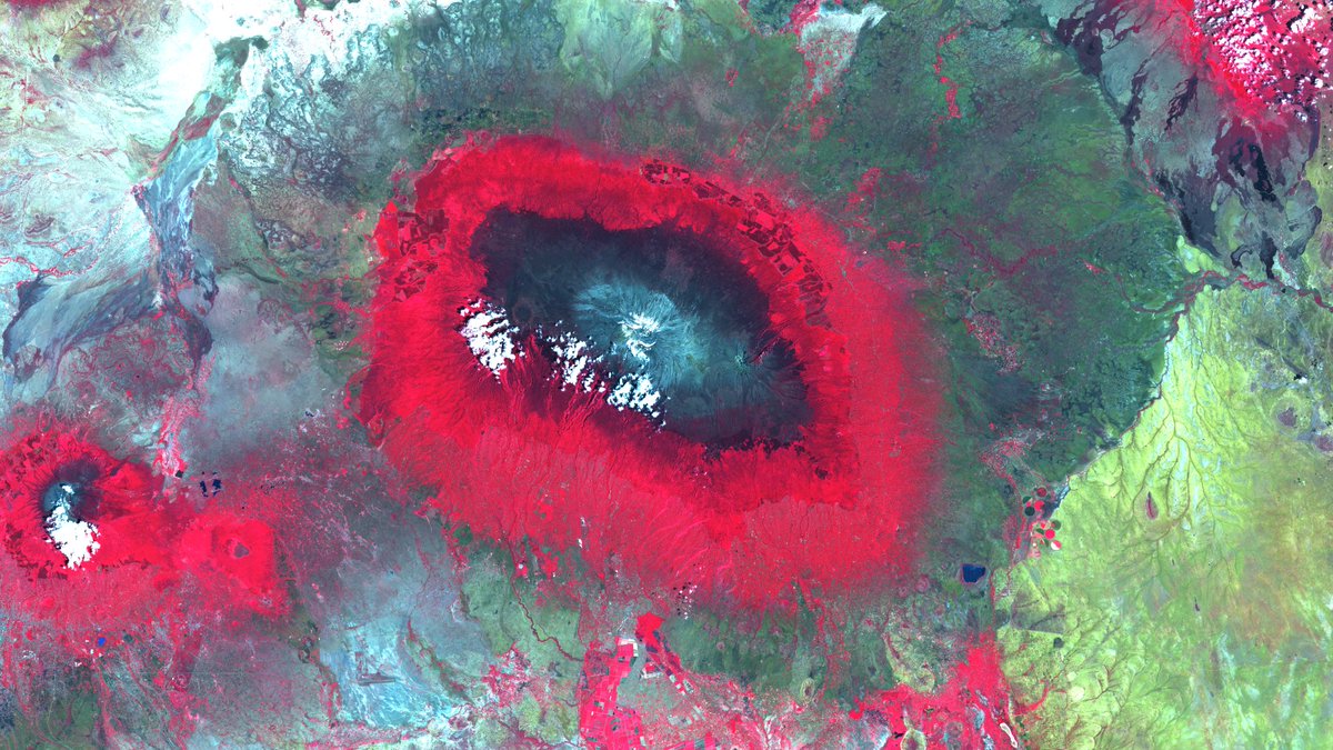
Stunning colours on the slopes of #MountKilimanjaro in #Tanzania. Visit our satellite image of the month May on: mundialis.de/en/satellite-i… Made with #OSGeo #Sentinel2 #Copernicus #satelliteimageofthemonth #Africa #vegetationzones #opendata #opensource
Our latest satellite image of the month shows the artfully meandering #AdelaideRiver in #Australia: mundialis.de/en/satellite-i… made with #OSGeo Now also with geo-localisation by @terrestrisde ! #Sentinel2 #Copernicus #satelliteimageofthemonth #NorthernTerritory #opendata #opensource

Wir & @terrestrisde sind nach DIN EN ISO 9001:2015 und DIN EN ISO 14001:2015 zertifiziert! 🌐🌱 Diese Meilensteine unterstreichen unser fortwährendes Streben nach Exzellenz und nachhaltiger Entwicklung: mundialis.de/qualitaets-und… #Qualitätsmanagement #Umweltmanagement


Two releases on one day! A 7.5.2 patch release fixing an issue with vector hit detection, and the exciting version 8.0.0 with several API improvements and the new StadiaMaps source replacing Stamen. Thanks to everyone who contributed! github.com/openlayers/ope…

OpenLayers 7.5 is out with a batch of great features and 10 first time contributors! Check out the release notes for details github.com/openlayers/ope…

@PhenoRob #careerfair im Universitätsclub Bonn. Mit @MundialisInfo und @terrestrisde. Wir freuen uns auf eine tolle Veranstaltung mit vielen interessanten Menschen 😊


#frischeKarten aus dem #Basemap-Labor: Unsere #3D-Beta-Dienste (basemap.de/beta_produkte_…) sind nun online! Es handelt sich um eine deutschlandweite 3D-Visualisierung auf Grundlage von #DGM5 und den #LOD2-Daten der Länder. #Karten #amtlich


Die Folien von unserem Vortrag "Geodatenanalyse in der Cloud - OGC API Processes und pygeoapi" von C. Mayer und H. Blitza (@terrestrisde) sind online verfügbar. ➡️ klips-project.github.io/fossgis2023/ #FOSSGIS2023 @pygeoapi @opengeospatial

Thanks to everyone who attended! Slides online at terrestris.github.io/fossgis2023/ta…

Slides for the @openlayers Feature Frenzy from @ahoce and me at #FOSSGIS2023 terrestris.github.io/fossgis2023/ta…
OpenLayers 7.3 is out just in time for your Saturday night mapping session! Some nice rendering and editing performance improvements in this release. Thanks to those who contributed, including 5 new first time contributors! github.com/openlayers/ope…
github.com
Release v7.3.0 · openlayers/openlayers
The 7.3 release includes rendering performance improvements with many layers, performance improvements when snapping during editing, and a handful of useful fixes. See the detailed list of changes...
Die AG Smart Mapping informiert am 09.03.2023 alle Interessierten über die aktuellen Entwicklungen im Projekt. Zugangsdaten zur Videokonferenz über: basemap.de/projekt_worksh…

Danke Sponsoren @FOSSGIS_Konf @camptocamp @WhereGroup_com @HumboldtUni @BKG_Bund @OPENGISch @terrestrisde @komoot @MundialisInfo GEOINFO AG @sourcepole @FiveTwoN @OpenCage Wagner-IT Geoinformatikbüro Dassau @latlon_de GKG-Kassel - Claas Leiner @geofabrik d.b.g. mbH @geoSYSnet !B

OpenLayers v7.20 is out \o/ github.com/openlayers/ope… … new features, perf. optimisations, interoperability++ (😍 OGC API - Tiles support) and *much* more. Thanks to all contributors!
github.com
Release v7.2.0 · openlayers/openlayers
The 7.2 release includes … …some new features (e.g. for icon styling), …performance optimisations (e.g. for canvas rendering), …better interoperability (e.g. OGC API - Tiles support, saner project...
Nur noch heute - Call for Participation @FOSSGIS_Konf: bit.ly/3UWVS4F Die #FOSSGIS2023 (15.-18.03.2023 in Berlin) ist die Communityveranstaltung für #OpenSource und #OpenData im Geobereich. #FOSSGIS #OSM #OSGeo


The European Space Agency @esa proudly announces the release of the WorldCover2021 map based on Sentinel-2 & Sentinel-1 constellations with 11 classes, 10m resolution, 77% accuracy independently validated Visit worldcover2021.esa.int @ESA_EO #EuropeanSpaceAgency #WorldCover2021

Our latest satellite image of the month shows a #WorldHeritageSite: The #GrandCanyon in #Arizona, #USA. Have a look at mundialis.de/en/satellitenb… made with #OSgeo #Sentinel2 #Copernicus #satelliteimageofthemonth #NorthAmerica


Auf der #FOSSGIS2022 zeigten wir, wie wir freie #Klimadaten und #Wetterdaten für #GIS-Anwendungen nutzbar machen. Danke für das Feedback! Vortrag: media.ccc.de/v/fossgis2022-… / Beitrag (S. 197 ff.): files.fossgis.de/Konferenz/foss… /cc @selectoid @FOSSGIS_Konf @terrestrisde @figura_richard


United States Trends
- 1. #UFC322 41.4K posts
- 2. Ewing 6,289 posts
- 3. Bama 19.5K posts
- 4. Arch Manning 1,794 posts
- 5. Wellmaker 4,400 posts
- 6. Oklahoma 29.8K posts
- 7. #AEWCollision 6,060 posts
- 8. Georgia 76.2K posts
- 9. Noah Thomas N/A
- 10. James Peoples N/A
- 11. Tracy Cortez 1,941 posts
- 12. Wingo 1,453 posts
- 13. Jeremiah Smith 2,345 posts
- 14. Bronny 5,663 posts
- 15. Ty Simpson 3,887 posts
- 16. Ole Miss 7,108 posts
- 17. Lebby N/A
- 18. Erin Blanchfield 1,035 posts
- 19. #Svengoolie 1,354 posts
- 20. #GoDawgs 5,425 posts


Something went wrong.
Something went wrong.