


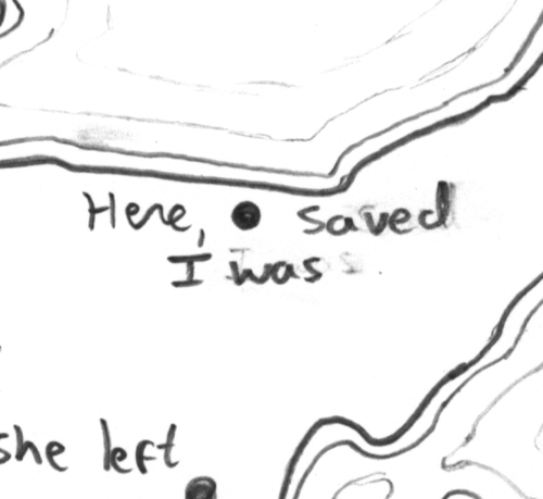
#30DayMapChallenge Day 30: Makeover 🏔️ This is it! Thirty maps in 30 (ahem… 35) days. For today’s prompt I revisited a map I started in the 2024 challenge, when I only managed to complete the coastline. This time, I gave it a proper makeover using the 1:250k LINZ contours
#30DayMapChallenge Day 29: Raster🎨 Today is a “paint by numbers” raster grid of soil moisture based on NASA’s SMAP. Shout out if you’d like a copy to “paint” yourself. Soil moisture is a key piece of the flood puzzle: when soils are already saturated, floods can escalate fast.
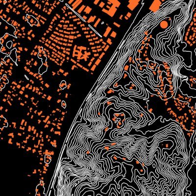
#30DayMapChallenge Day 28 Black ⚫ For today’s prompt I worked entirely in black, letting texture and material determine the map’s form. Three layers come together to depict the buildings, roads and background of Te Herenga Waka Victoria University of Wellington’s Kelburn campus.
#30DayMapChallenge Day 27: Boundaries 🍮 The Hutt River flood extent in Jello and wafer paper. The coastline is often represented as a hard line on maps, and I played with the idea of rethinking permeable boundaries.
#30DayMapChallenge Day 26: Transport 🚣♀️ Today’s map charts Wairarapa Moana in beads. Each bead represents 10 sq km. The lake was an important part of pre-colonisation transport for Māori, connecting communities, resources & seasonal movements across the landscape.
#30DayMapChallenge Day 25: Hexagons 🔷 I started this hexagon map for the 2024 challenge but didn’t get very far at the time. This year I finished the stitching and added the legend. The map shows population density change from 2018 to 2023 using New Zealand Census data.
#30DayMapChallenge Day 24: Places & Their Names 🏞️ I want to introduce you to Wairarapa Glistening Water. A co-designed website that weaves video, audio, text, VR & maps to allow 5 wetlands to tell their kōrero (stories). Co-designed w Ngāti Kahungunu ki Wairarapa
#30DayMapChallenge Day 23: Process 🧵🗺️ Today’s post is less about the final map and more about how it came to be. Turning soil lead concentration data into a field of crocheted hexagons. Data sources: GNS Science Report 2023/23 & LINZ
#30DayMapChallenge Day 22: Data Challenge: Natural Earth🌏 Today’s map of plate boundaries is created from string and beads on paper. The Natural Earth dataset, recentered on Aotearoa New Zealand, is shown using an equal-area projection. Pacific grouping boundaries also shown.
#30DayMapChallenge Day 21 Icons⚽ Today's map shows focal mechanism diagrams (based on moment tensors) for earthquakes in New Zealand from 21 Oct to 21 Nov this year. Each of the 11 ‘beachballs’ shows the style of faulting and the direction of slip during each earthquake.
#30DayMapChallenge Day 20: Water 💧 Today’s map uses free-motion quilting techniques on paper to trace part of the flood extent from Cyclone Gabrielle. The blue organza overlays the aerial imagery, letting the landscape show through while evoking the shimmer and movement of water
#30DayMapChallenge Day 19: Projections🏖️ I cannot take credit for today’s “map”. Our wonderful Felipe Perez has been getting the School’s augmented reality sand table up and running again. The sand table is an amazing way to talk with future students about basic spatial concepts.
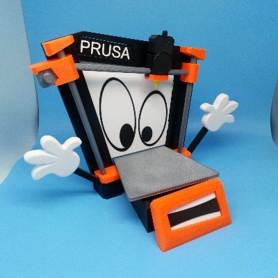
#30DayMapChallenge Day 18 – Out of This World 🌕 Today’s attempt was meant to be a glow-in-the-dark 3D print of a lunar DEM. Instead, the printer gods intervened. Failure is part of the research process and we got: an out-of-commission printer and some ideas for the future.
#30DayMapChallenge Day 17: A New Tool🌋 Today’s map stitches together the deformation pattern underlying Lake Taupō. The thread traces uplift and subsidence observed over 42 years of lake-levelling surveys. Data: doi.org/10.1080/002883…
#30DayMapChallenge Day 16: Cell – The Risk of Rising Water 🌊 Today’s map stitches together a view of flood risk in Lower Hutt, with a thread grid atop a printed map underlay. Data: GWRC, LINZ, Eagle Technology.
#30DayMapChallenge Day 15: Fire 🔥 For today’s map, I leaned into the theme and used fire to map fire. New Zealand saw a substantial wildfire in Tongariro last week; though still around 2,000 hectares smaller than the 2020 Lake Ōhau blaze mapped. Wildfires are a dynamic hazard.
#30DayMapChallenge Day 14: OpenStreetMap 🌐 Today’s (slightly late due to grading!) map plays with the idea of layers by using stacked overhead transparencies to physically build the map piece by piece: OSM building outlines and tsunami risk zones.
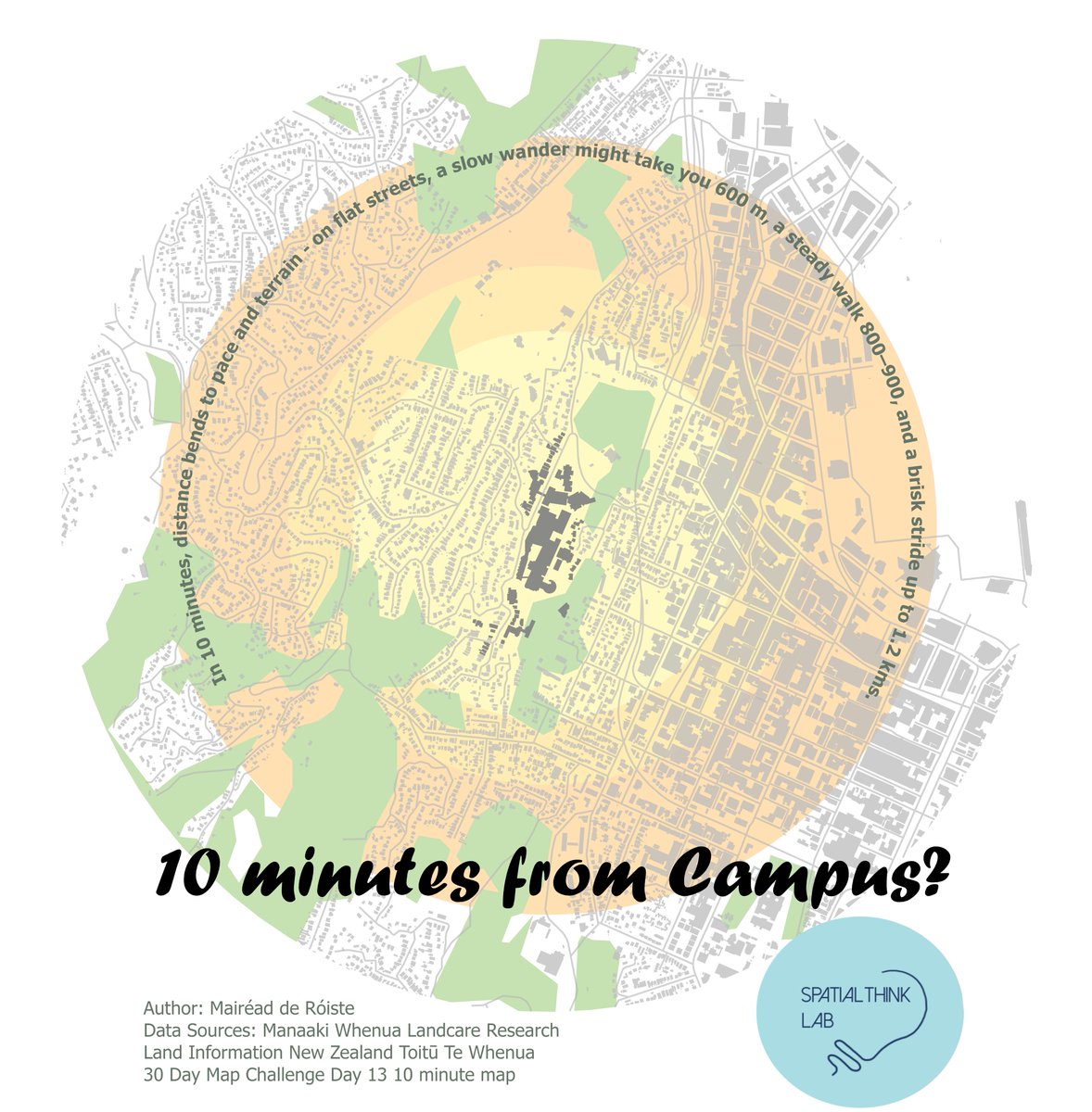
#30dayMapChallenge Day 13 10 minute map: 10 minutes from campus? In 10 minutes, distance bends to pace and terrain - on flat streets, a slow wander might take you 600 m, a steady walk 800–900, and a brisk stride up to 1.2 kms. But Wellington isn't flat...
#30DayMapChallenge Day 12: Map from 2125 IPCC’s projections for June - August 2021–2040 temperatures under SSP3-7.0 White-Dk red: 0.5, 1, 1.5, 2.5°C I went off-prompt and imagined, global temperature change has stabilised at no more than +2°C Data: doi:10.1017/9781009157896.006
#30DayMapChallenge Day 11: Minimal Map – Hikurangi Subduction Zone🪡 A single sweeping line of tambour beading traces where the Pacific Plate dives beneath the Australian Plate along Aotearoa’s east coast. The Hikurangi Subduction Zone is NZ’s largest & most active fault boundary


United States 趨勢
- 1. Miami 80.6K posts
- 2. Miami 80.6K posts
- 3. Marcel Reed 2,227 posts
- 4. Carson Beck 3,001 posts
- 5. Dawson 6,336 posts
- 6. Isak 29.3K posts
- 7. Romero 18.5K posts
- 8. Liverpool 66.8K posts
- 9. Toney 3,698 posts
- 10. #CFP2025 N/A
- 11. Clinton 464K posts
- 12. Carter Davis N/A
- 13. Jayden Quaintance 1,569 posts
- 14. St. John 5,797 posts
- 15. Wirtz 28.6K posts
- 16. #TOTLIV 19.2K posts
- 17. Lowe 9,765 posts
- 18. Fletcher 5,839 posts
- 19. Tottenham 30.7K posts
- 20. Cristobal 2,699 posts


Something went wrong.
Something went wrong.