
StormchaserJS
@stormchaserjs
Meteorologist at National Weather Forecasting INC. SkyWarn spotter for BOX. Weather observer & storm chaser. @PSUWorldCampus alumn
You might like


🥶 Frigid temperatures are forecast to expand southward into much of the Southeast and Gulf Coast early next week. Numerous daily record lows are possible on Tuesday, November 11. Check weather.gov for local forecasts and specifics regarding frost/freeze concerns.


Strat warm and weakened PV will help with below normal temps for much of December. January may be warmer than normal with the PV strengthening.


MJO forecast suggests warmer than normal for much of the US for November then cooler than normal for much if not all of December


Euro weekly forecasted temperature anomalies next 4 weeks. More widespread cooler then normal starting December


Euro weekly temperature anomalies mid and late December


The Canadian model is being upgraded April 2026. more info here. collaboration.cmc.ec.gc.ca/cmc/cmoi/produ…
The National Blend of Models is being upgraded in April 2026. More info here. vlab.noaa.gov/documents/6609…
The latest Euro weekly forecast thru mid-December is basically what you’d expect for a typical La Niña December over the last 30 years: A faster-than-usual start to winter over the east-central US with plenty of high-latitude blocking


Will be feeling like winter for many in the eastern US early next week as a big shot of cold air moves in form Canada. Snow also for some!


Here is a listing of strong wind gusts from the overnight period late Wednesday Evening to early Thursday AM. #mawx #riwx #ctwx


1:54pm CST #SPC Day1 Outlook Marginal Risk: across the Pacific Northwest Coast and across the Lower Great Lakes into parts of New England spc.noaa.gov/products/outlo…

10:29am CST #SPC Day1 Outlook Marginal Risk: ACROSS THE NORTHEAST AND OREGON/NORTHERN CALIFORNIA COASTS spc.noaa.gov/products/outlo…

6:45am CST #SPC Day1 Outlook Marginal Risk: across the Northeast and Oregon/northern California coasts spc.noaa.gov/products/outlo…

Forecasted radar for our cold front and storm today into tonight. A fine line of downpours will enhance the damaging wind risk. Some thunder also in the mix.
From last night's damaging winds in Mattapoisett, MA - we have found a weather station with a measured wind gust of 74 MPH sustained at 54 MPH at 1049 PM Monday Evening 11/3/25. See wunderground.com/dashboard/pws/… for info. #mawx #riwx #ctwx @1degreeoutside @JimCantore

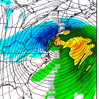
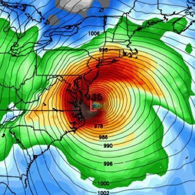
A tight surface pressure gradient across the NE allowing for strong to damaging wind gust tonight. Any heavy showers will enhance the wind risk along the cold front.

11:37pm CST #SPC Day1 Outlook Marginal Risk: for parts of the Pacific Northwest Coastline and portions of the Northeast spc.noaa.gov/products/outlo…

SKYWARN Self-Activation will monitor strong to damaging wind potential across all of SNE and possibly a few isolated strong to severe thunderstorms in Western MA/CT late Wednesday Night thru Thursday AM. See wx1box.org/2025/11/05/win… for info. #mawx #riwx #ctwx


United States Trends
- 1. #Worlds2025 68.5K posts
- 2. Doran 34.2K posts
- 3. #T1WIN 36.4K posts
- 4. Faker 49.2K posts
- 5. Good Sunday 53.5K posts
- 6. Silver Scrapes 4,138 posts
- 7. #sundayvibes 3,813 posts
- 8. #T1fighting 3,940 posts
- 9. Guma 7,858 posts
- 10. O God 7,624 posts
- 11. Blockchain 197K posts
- 12. Keria 14.9K posts
- 13. Faye 51.1K posts
- 14. Option 2 4,540 posts
- 15. #LeagueOfLegends 6,399 posts
- 16. Vergil 9,046 posts
- 17. OutKast 24K posts
- 18. Boots 30K posts
- 19. Sam Houston 1,644 posts
- 20. Lubin 6,041 posts
You might like
-
 Boston Weather Consulting (by Owen)
@BostonWxConsult -
 Michael Barletta
@MikeBWeather -
 Will Ciccone
@weatherwilly -
 🌞 Henry Swenson 🌱
@HenrySwenson -
 #LOCKITIN
@lockingitin -
 eweather
@Eweather13 -
 Stephen Eckhardt ☀️
@seckhardt -
 BGWX
BGWX
@BradyBGWX -
 🦄NPCJoey🦄
@npcjoeyy -
 Mike Masco
@MikeMasco -
 Matthew Ferreira | MassachusettsWx
@MassachusettsWx -
 Mitch
Mitch
@VermonsterWx -
 Paul
Paul
@weatherwiz -
 IsaacWxObserver
@IsaacWxObserver -
 Cristopher Cace
@ccace_wx
Something went wrong.
Something went wrong.