Voxelmaps
@voxelmaps
Our mission is to build a true 4D volumetric model of the planet, combining visual, spatial & temporal data to create the most detailed map of the world!
You might like
What can a spatially intelligent digital twin do? Spot risks like vegetation encroachment before they cause problems—transforming energy ops from reactive to predictive. This LiDAR view isn’t just a map—it’s a smarter, resilient future. #DigitalTwin #LiDAR #PredictiveMaintenance

What are you really seeing here? A #LiDAR-derived point cloud of a street in the #EastBay—where every color-coded object reveals poles, wires, and vegetation, all spatially classified. This is how utilities see risk before it happens. #Voxelmaps #DigitalTwin #UtilityInspection

Scaling autonomous operations demands more than basic maps. Voxelmaps delivers diverse, high-fidelity data to help machines see, hear, and understand the real world—powering smarter, inclusive AV systems. Ready to lead the future of autonomy? Let´s talk. #AutonomousVehicles

Real-world #AI demands real-world data. #Voxelmaps delivers high-fidelity 3D environments—like this street scene—to power autonomous systems, AR/VR, and advanced computer vision at scale. Discover how comprehensive global data can accelerate your AI. #ComputerVision #HDMapping

At the recent Accenture International Utilities and Energy Conference, Brian Soliday explored one of the sector’s most pressing shifts: moving beyond static geospatial tools toward dynamic, AI-powered Spatial Digital Twins. (1/2) #EnergyTransition #DigitalTwins #AIinEnergy

From palm-lined streets to dense urban corridors, we capture the world in detailed 3D—powering AI to interpret space, sound, & objects like humans do. From AV navigation to smart cities and AR/VR, our global data solutions scale human-centric datasets that digitize the world.

Authenticity in data matters. Our datasets reflect real-world conditions with the detail and dimensionality needed to power next-generation #DigitalT#wins. From facilities management to city-scale modeling, #Voxelmaps delivers high-precision, multi-sensor data pipelines.

Transform LiDAR & imagery into rich 3D insights with Voxelmaps Insight Platform (VIP). Scalable, AI-powered mapping for AVs, telecom & smart cities—indoor or out, with cm-level precision. 🔗 voxelmaps.com/products/voxel…

Precision in Play: From Batter's Box to Stands (and Beyond). At Voxelmaps, every measurement tells a story. Whether it’s the distance from home plate to the front-row seats or the arc of a potential home run, our geospatial technology captures it all with high-level accuracy.

Providing a view into the evolution in how we perceive & manage our vital energy infrastructure, to move 'Beyond Mapping’, towards a predictive-based future powered by 4D Spatial Digital Twins. Thanks to all the organizers & attendees we’re heading home full of ideas! 2/2

Wrap up of #IUEC2025: Voxelmaps team had an inspiring few days at this years Accenture International Utilities and Energy Conference where our own CRO Brian Soliday gave a presentation on Beyond Mapping: Dynamic AI-Powered Spatial Digital Twins for the Future Energy Ecosystem 1/2
Today at #IUEC2025: Don’t miss Voxelmaps CRO Brian Soliday at 9–10AM during Innovation Hour! Topic: Beyond Mapping: AI-Powered Spatial Digital Twins for Energy. Photo of Julie Sweet, Accenture CEO & Chair, session yesterday. #Voxelmaps #Utilities #AI #Innovation

Fueling smarter #AISystems with massive, real-world #datasets. We provide meticulously curated data to ensure your AI models are robust, unbiased, and perform optimally. Our global capabilities help make your B2B solutions world-ready.

Observe the detail: from the unique architecture to each of the numerous cars filling this space, Voxelmaps captures it all. Our high-fidelity 3D models can distinguish individual assets even in complex scenes like this, providing invaluable data to understand dense environments.

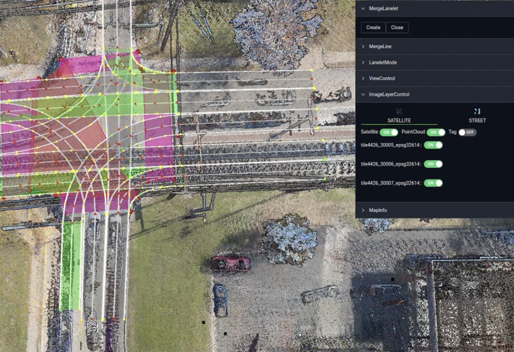
Precision in every voxel, every vector. Voxelmaps delivers high-definition mapping solutions that form the foundation for advanced driver-assistance systems (ADAS) and autonomous vehicle (AV) navigation. #Voxelmaps #VectorMap #LaneDetection #ADAS #AutonomousDriving #HDMapping
A new view of the #GoldenGateBridge — experience infrastructure intelligence from the sky down, or from the road, or via backpack collection. #Voxelmaps is fully multi-modal in our data collection routines. #DigitalTwins #InfrastructureMapping #SmartCities

Data accuracy and operational efficiency are make-or-break factors for autonomous vehicle success. Learn how Voxelmaps is helping industry leaders reduce risk through their data solutions, enabling businesses to scale smarter voxelmaps.com/news/mitigatin…
voxelmaps.com
Mitigating Risk: Ensuring Data Accuracy and Operational Efficiency in Autonomous Vehicle Development
The success of autonomous vehicles hinges on data accuracy and efficiency. Learn how Voxelmaps' advanced mapping solutions help mitigate risk and enable safer, smarter autonomous vehicle development.
At Voxelmaps, we operate on a global scale, delivering comprehensive and diverse #datasets to power innovation worldwide. 🔹 Worldwide Studies, Collection at Scale 🔹 Unmatched Dataset Depth 🔹 End-to-End Services No matter the scale or complexity, we’ve got you covered.

As WGIC Horizons 2025 wraps up on its final day, one thing is clear—the future of geospatial is dynamic. The valuable insights shared by speakers and industry leaders, proved how exciting the times are ahead for Voxelmaps and the geospatial community.


Stop — and take a closer look. What looks like a simple road marking is actually a powerful data point with #Voxelmaps’ #mobilemapping. Our precise spatial data helps AV, utilities, and infrastructure teams make faster, smarter decisions. #StopAndSeeTheData #DigitalTwins

United States Trends
- 1. #Worlds2025 46.3K posts
- 2. Doran 19K posts
- 3. #T1WIN 29.4K posts
- 4. Good Sunday 47K posts
- 5. Faker 33.1K posts
- 6. Sam Houston 1,622 posts
- 7. Oregon State 4,750 posts
- 8. #T1fighting 3,621 posts
- 9. Vergil 8,807 posts
- 10. Boots 30K posts
- 11. Option 2 4,360 posts
- 12. Lubin 5,922 posts
- 13. #Toonami 2,731 posts
- 14. Keria 11.4K posts
- 15. Hyan 1,490 posts
- 16. Frankenstein 127K posts
- 17. Louisville 14.5K posts
- 18. UCLA 7,841 posts
- 19. #GoAvsGo 1,607 posts
- 20. Oilers 5,382 posts
You might like
-
 Wonderland Engine
@WebXREngine -
 My Jewelry Repair
@MyJewelryRepair -
 TimeSolv
@TimeSolv -
 DigiLens Inc.
@DigiLensInc -
 CREAL
CREAL
@CREAL_3D -
 echo3D
@_echo3D_ -
 VitarGames
@VitarGames -
 Zimmerman Industries, Inc.
@Zim_Mixer -
 NeuroTracker
@NeuroTrackerCSi -
 Flow Immersive
@flowimmersive -
 PaleBlue - Immersive Employee Training
@palebluexr -
 National Special Districts Association
@NSDAdistricts -
 Arkio
Arkio
@ArkioHQ
Something went wrong.
Something went wrong.


