#4warn search results


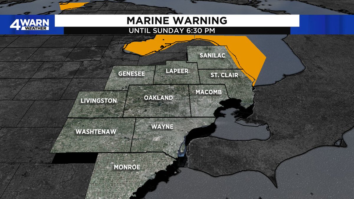
A SPECIAL MARINE WARNING is in effect until 6:30 p.m. Sunday for the nearshore and open waters of Lake Huron from Port Austin to Port Huron. Storms in the vicinity have the potential for winds in excess of 34 knots. #4Warn #Weather @Local4News

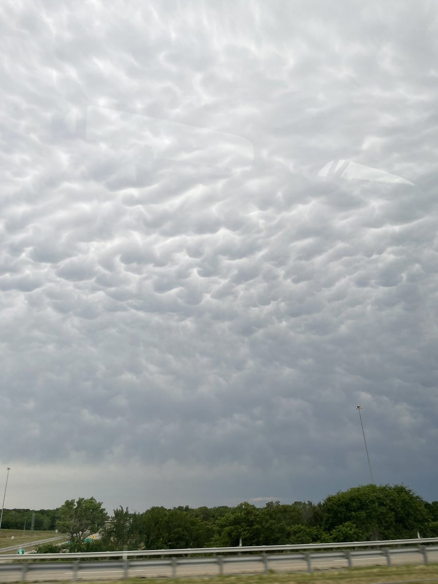
Driving past Henrietta on our way home. Fun clouds as we skirt just north of the storms blowing up. #okwx #4warn @emilyrsutton
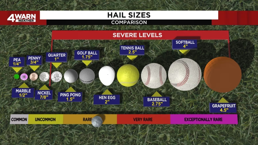
Hail reports into the National Weather Service: Ping pong-sized: Elba Twp, Lapeer Co. at 2:57 p.m. Tennis ball-sized: Davison, Genesee Co. at 3 p.m. Ping pong-sized: NW Detroit, Wayne Co. at 3:10 p.m. #4Warn #Weather @Local4News
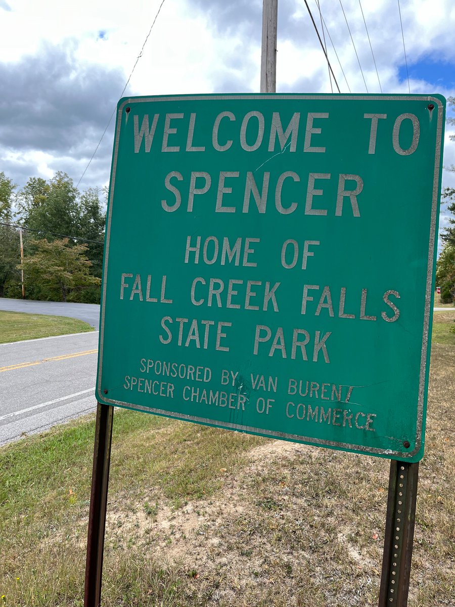
Visited your namesake city today on the state park bike tour, @LisaSpencerWSMV . And the #4Warn forecast was right on for Saturday! Absolutely no rain for us on the plateau.


⚡️#4WARN radar is getting an early start across SW Utah on this Thursday morning! Areas of heavy rain, lightning, and gusty winds are quickly developing. ☔️ Look for some ponding on the roadways and dangerous conditions for kiddos off to school this morning! #utwx
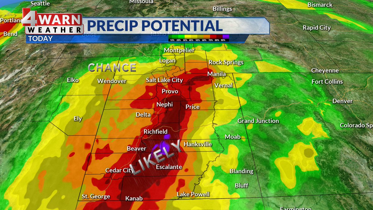
#4WARN: Scattered Storms Develop Saturday! Monsoon flow will trigger scattered storms around the Beehive state Saturday! A large part of the state has been upgraded to a level 2/5 risk for microburst winds, hail, and flood potential. Stay weather aware! #utwx
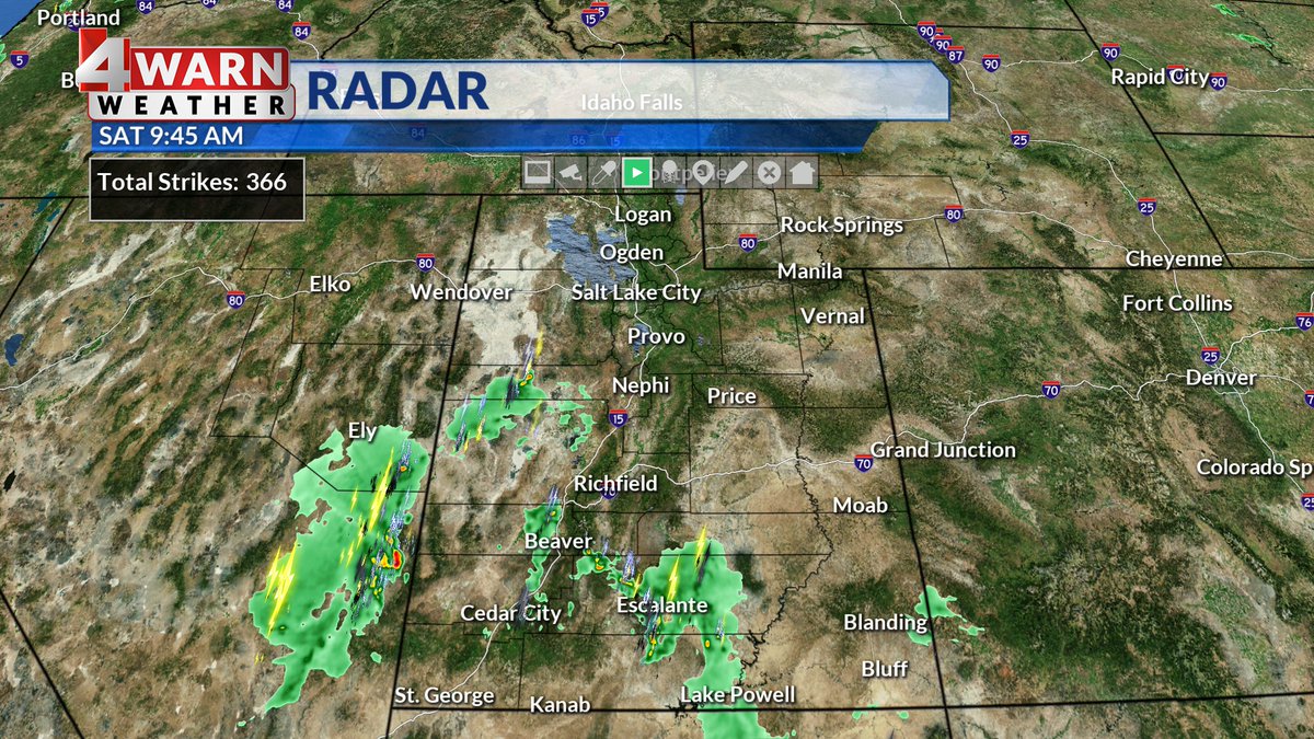

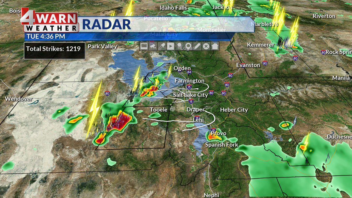
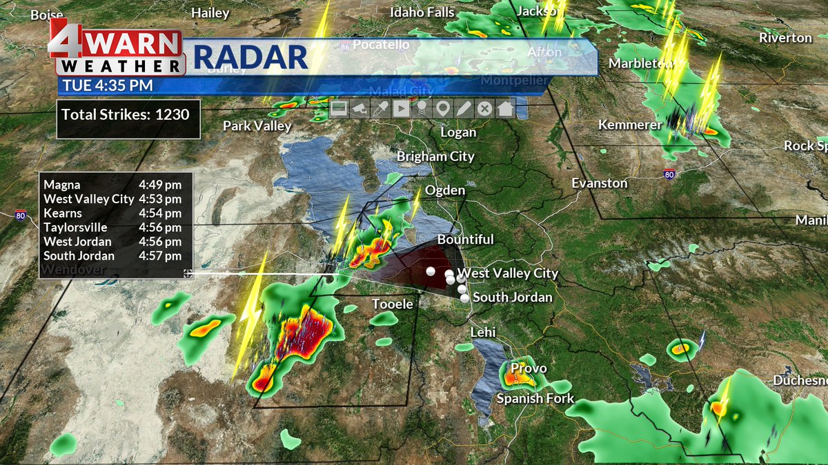
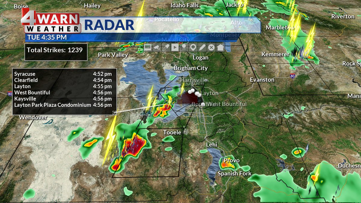
1:45 PM- Storms developing across central & northern portions of Utah are putting on quite the light show this afternoon. Nearly 1500 lightning strikes in the past 30 minutes! Stay safe out there! #utwx #4WARN @abc4utah
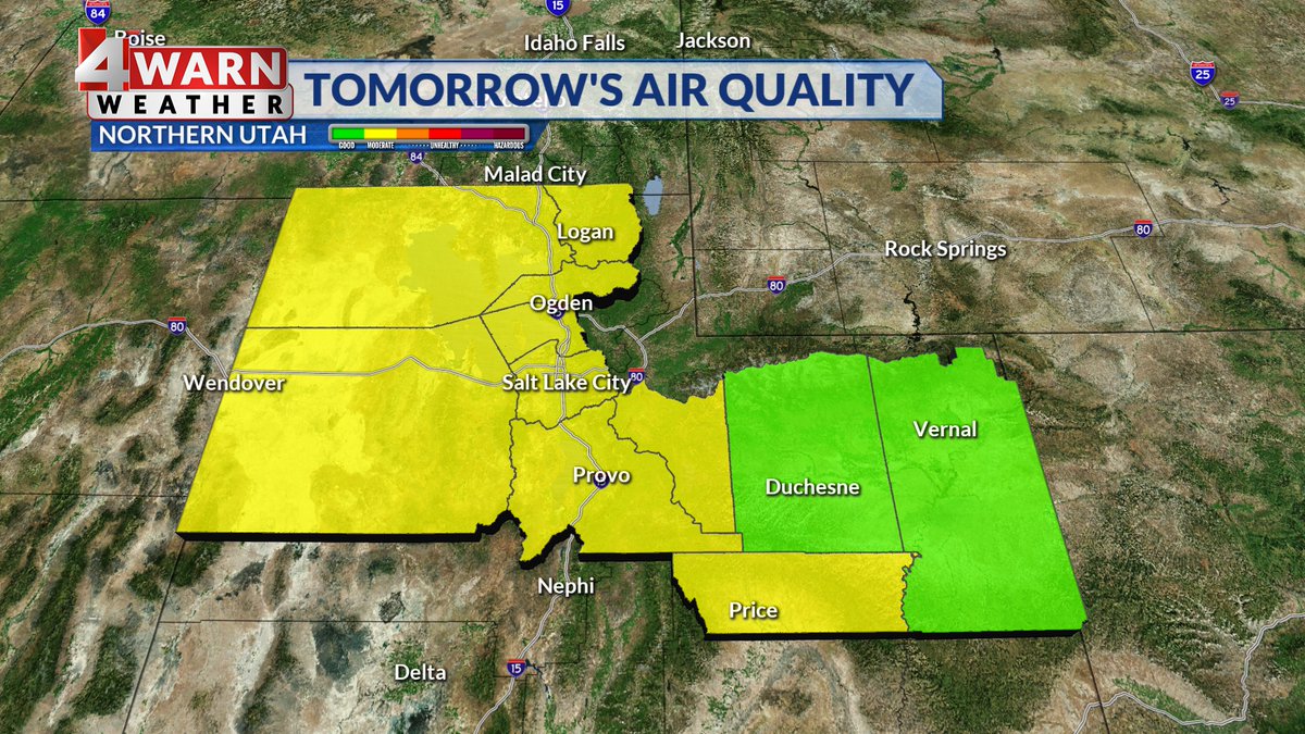
#4WARN: Air quality alert: SW flow will drag in denser wildfire smoke into parts of the state-- visibility will be impacted with smoke filled skies and air quality could be impacted as a result. Moderate air expected along the Wasatch Front. #utwx @abc4utah


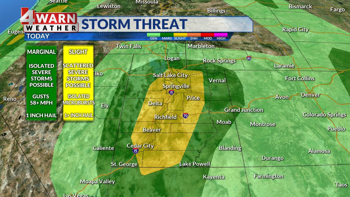
#4Warn: Did you see the upgraded thunderstorm threat? Slight risk in yellow & includes the Wasatch Front — heavy rain, scattered severe storms, large hail & plenty of lightning with developing storms.. #utwx @abc4utah
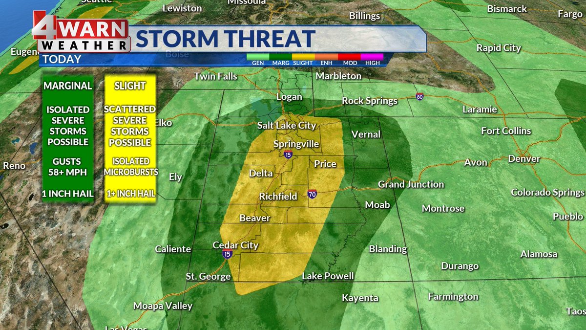
ROUND 2! #4warn: SEVERE STORMS TRACKING TOWARD THE WASATCH FRONT! We have a line of severe thunderstorms that will be impacting Weber, Davis, Salt Lake & Tooele Counties through 5 pm -60+mph winds & quarter sized hail Seek shelter in the path of these storms #utwx @abc4utah
1 PM Update: Showers & storms are developing across western Utah this afternoon. Heavy rainfall, frequent lightning, and gusty winds up to 40-50 mph are possible over the next hour or two. #utwx @abc4utah #4Warn
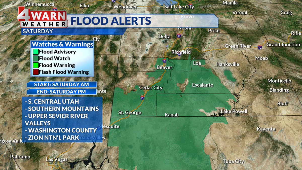
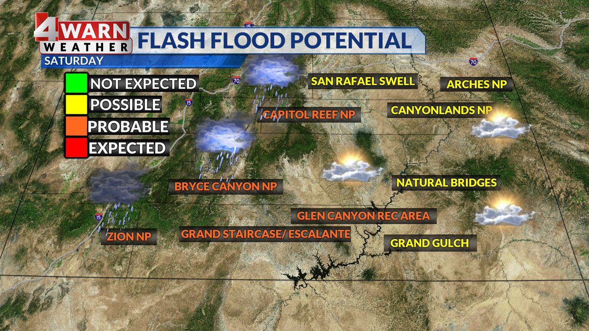
#4WARN: "Please don't become a statistic" It's what the @NWSSaltLakeCity says to those wanting to hike slot canyons, low lying areas & flood prone spots including @ZionNPS We have excessive rain, probable flash flooding, a flood watch & strong storms Saturday @abc4utah
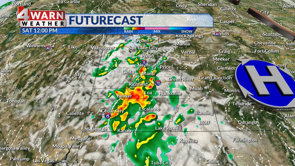
#4WARN TIMING OF SATURDAY STORMS: It starts early! We have strong thunderstorms (severe storms possible) in Southern #Utah Sat AM & moisture surges north to Wasatch Front. Active skies for the afternoon, evening & into the overnight for some! Statewide potential- #utwx @abc4utah
#4WARN STORM BREAKDOWN: Valley rain & mountain snow has arrived! We get a soggy setup into Thursday AM, periods of rain/snow through Thursday, falling snow levels Thursday night & scattered snow showers Friday! Stay with @abc4utah for updates! #utwx


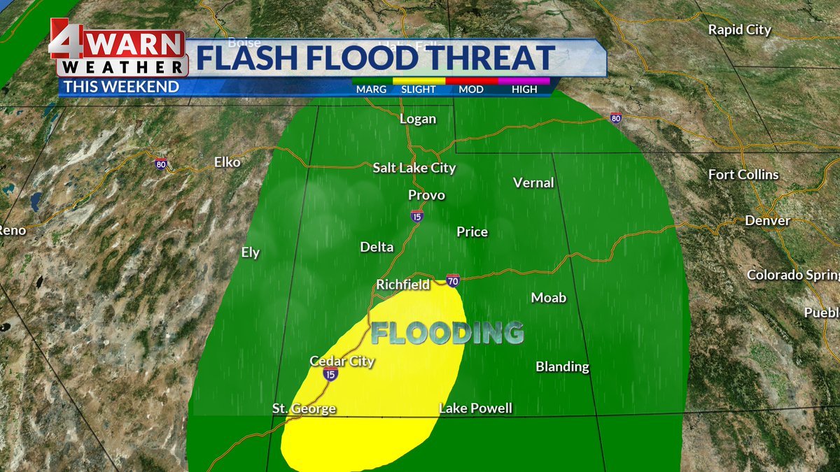
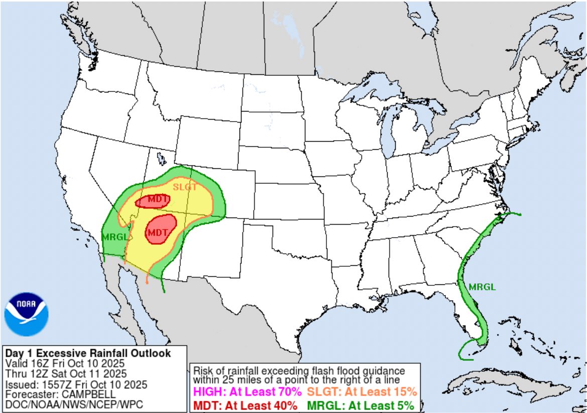
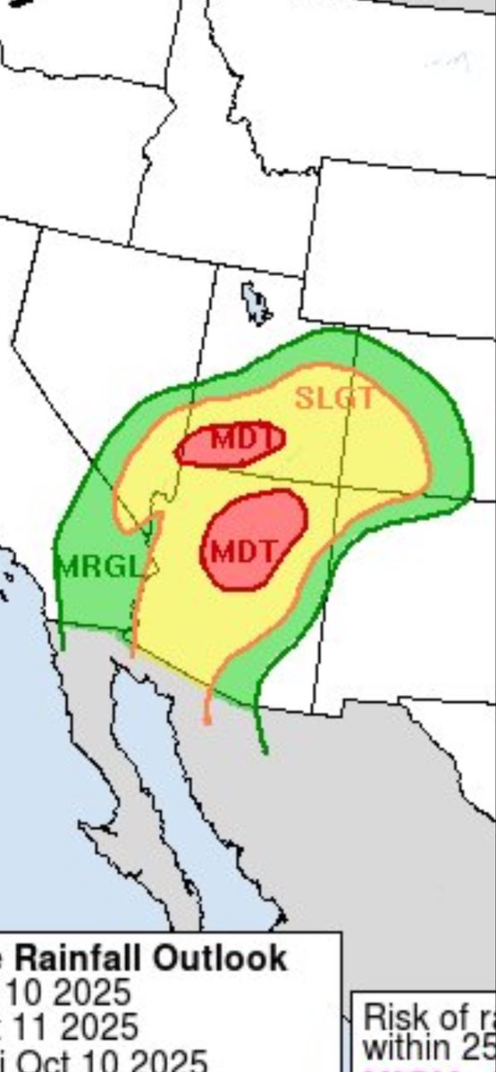
#4WARN: Today is a dangerous day for flooding in the southern half of Utah. SW #Utah has been upgraded to a moderate excessive rainfall risk today. The last time this happened? Sept. Of 2022. Take all warnings seriously, seek higher ground & NEVER drive thru flood waters #utwx
#4Warn: Campers evacuated from new #BeulahFire burning near Mirror Lake Highway. Dry conditions, winds & heat allowing flames to spread quickly. Already up to 300+ acres burnt. In the area? Can you see it? Red Flag Warnings for parts of #Utah Friday & Saturday #utwx @abc4utah


My backyard is a river and the nearby golf course is a lake. I consider myself blessed that there wasn’t more damage. Did you have damages? Stay weather aware, there is more to come. #4WARN #storms
#4WARN STORM BREAKDOWN: Valley rain & mountain snow has arrived! We get a soggy setup into Thursday AM, periods of rain/snow through Thursday, falling snow levels Thursday night & scattered snow showers Friday! Stay with @abc4utah for updates! #utwx
Visited your namesake city today on the state park bike tour, @LisaSpencerWSMV . And the #4Warn forecast was right on for Saturday! Absolutely no rain for us on the plateau.
#4WARN: Air quality alert: SW flow will drag in denser wildfire smoke into parts of the state-- visibility will be impacted with smoke filled skies and air quality could be impacted as a result. Moderate air expected along the Wasatch Front. #utwx @abc4utah
#4WARN: Air quality alert: SW flow will drag in denser wildfire smoke into parts of the state-- visibility will be impacted with smoke filled skies and air quality could be impacted as a result. Moderate air expected along the Wasatch Front. #utwx @abc4utah

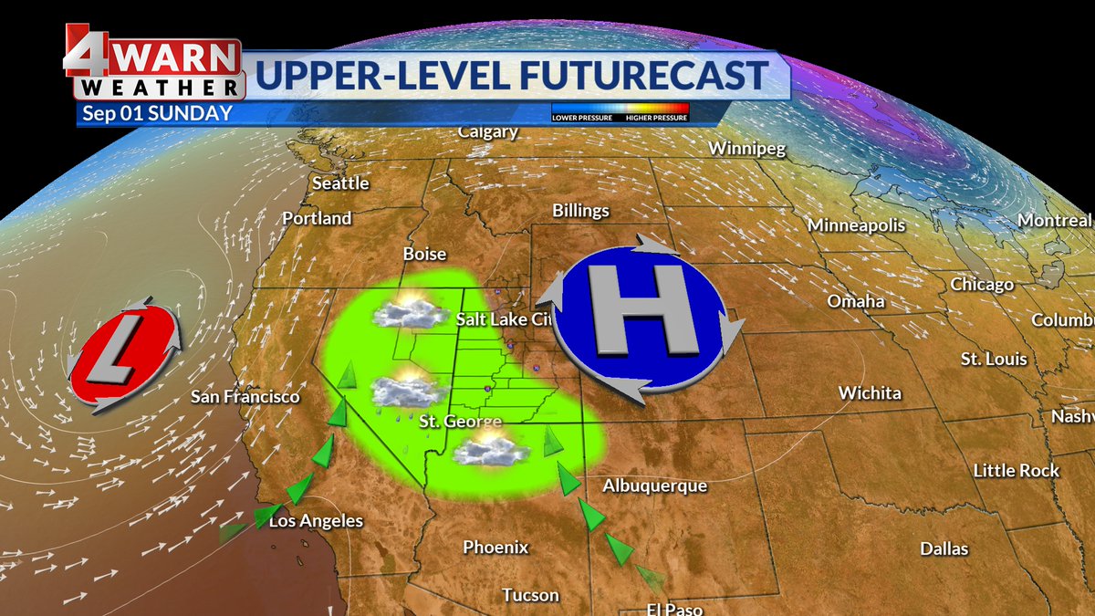
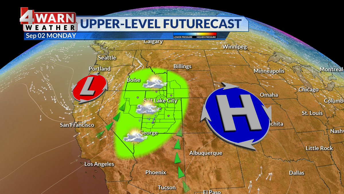
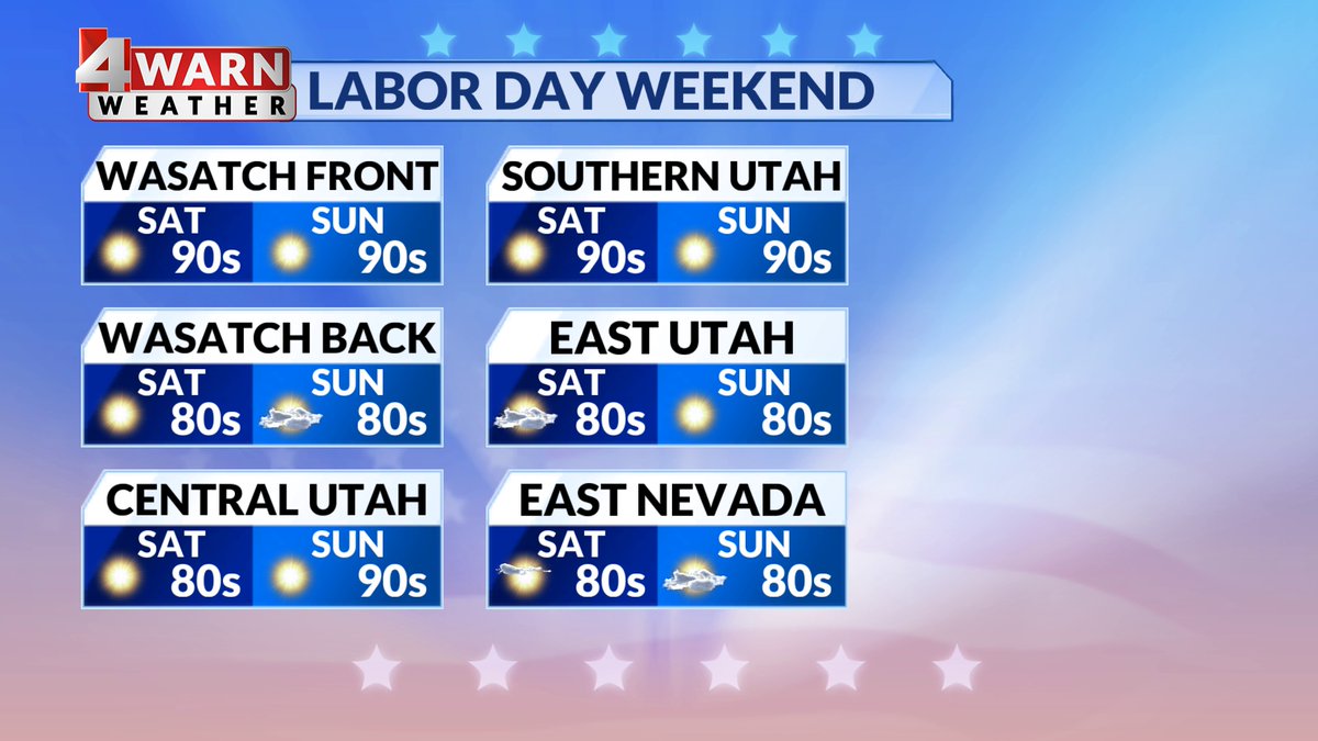
#4WARN: Positioning of the high could lead to a bit of monsoon moisture sneaking back into #Utah and allowing for some isolated thunderstorms for Labor Day weekend Saturday: SW Utah Sunday: Southern, Central & West Desert Monday: Northern & Central Utah #utwx @abc4utah


#4WARN: Positioning of the high could lead to a bit of monsoon moisture sneaking back into #Utah and allowing for some isolated thunderstorms for Labor Day weekend Saturday: SW Utah Sunday: Southern, Central & West Desert Monday: Northern & Central Utah #utwx @abc4utah


Planning for #LaborDayWeekend in #Utah? We could see moisture return with a chance of isolated storms in Southern Utah & Central Utah for the weekend-The holiday could bring an isolated storm to Northern & Central Utah. Eyes to the skies! @abc4utah #4Warn
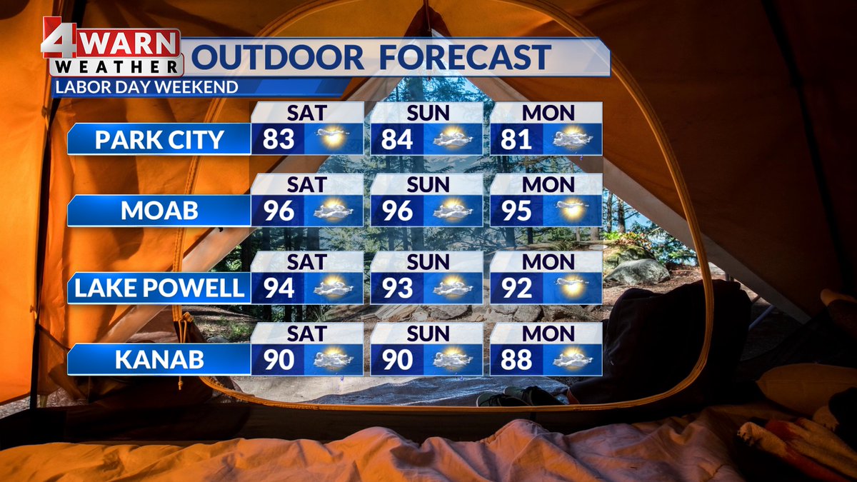

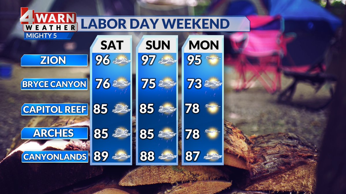
Planning for #LaborDayWeekend in #Utah? We could see moisture return with a chance of isolated storms in Southern Utah & Central Utah for the weekend-The holiday could bring an isolated storm to Northern & Central Utah. Eyes to the skies! @abc4utah #4Warn

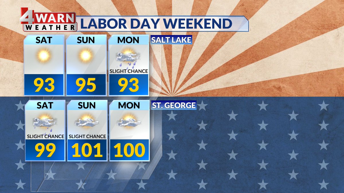

#4WARN for #LaborDay Weekend in #Utah- Right now, a warming trend kicks off Friday and allows for above average temperatures throughout Utah. St. George will see highs hang near triple digits. Slight chance of storms Sat/Sun esp in mtns. Stay #utwx aware!


⚡️#4WARN radar is getting an early start across SW Utah on this Thursday morning! Areas of heavy rain, lightning, and gusty winds are quickly developing. ☔️ Look for some ponding on the roadways and dangerous conditions for kiddos off to school this morning! #utwx
⚡️#4WARN radar is getting an early start across SW Utah on this Thursday morning! Areas of heavy rain, lightning, and gusty winds are quickly developing. ☔️ Look for some ponding on the roadways and dangerous conditions for kiddos off to school this morning! #utwx
⚡️#4WARN radar is getting an early start across SW Utah on this Thursday morning! Areas of heavy rain, lightning, and gusty winds are quickly developing. ☔️ Look for some ponding on the roadways and dangerous conditions for kiddos off to school this morning! #utwx
#4Warn: Did you see the upgraded thunderstorm threat? Slight risk in yellow & includes the Wasatch Front — heavy rain, scattered severe storms, large hail & plenty of lightning with developing storms.. #utwx @abc4utah
#4WARN: Scattered Storms Develop Saturday! Monsoon flow will trigger scattered storms around the Beehive state Saturday! A large part of the state has been upgraded to a level 2/5 risk for microburst winds, hail, and flood potential. Stay weather aware! #utwx


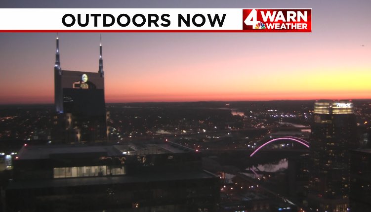
Join @Mel_Orlins & @JordanNews4 right now for your latest headlines -- including the details on a major overnight power outage, an update on Jim Kelly's recovery and @mikecejka4's #4Warn forecast. #WakeUp is live until 9 a.m.!


Tune in now to join @Mel_Orlins and @JordanNews4 for your latest local headlines. Plus, more beautiful weather is on the way! @mikecejka4 has your #4Warn forecast. We're live until 9 a.m. on #News4 #WakeUp

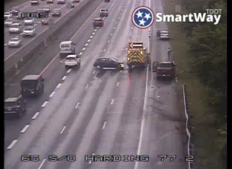
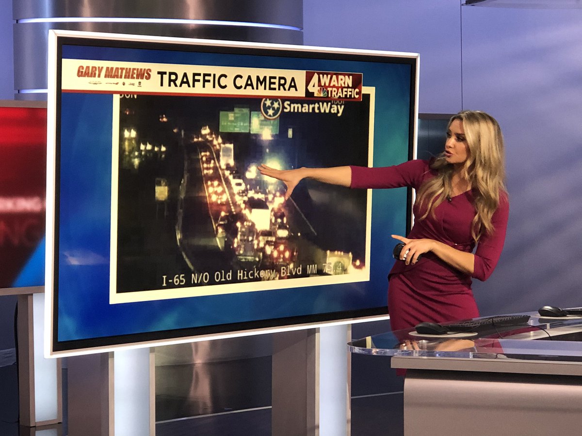
Messy messy on I-65 north close to Vietnam Vets 🥴 I’m getting you around delays on @WSMV in a few minutes! #4WARN #traffic

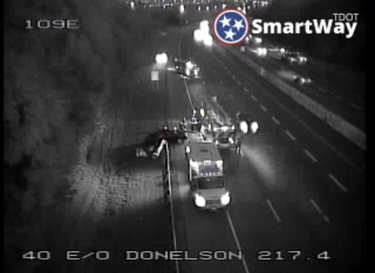
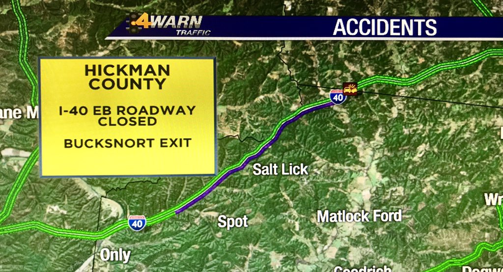
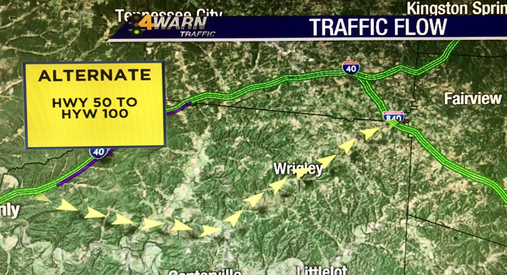
HICKMAN COUNTY: I-40 EB is closed a few miles past the Bucksnort exit. Take Hwy 50 to Hwy 100 @WSMV #4WARN #traffic

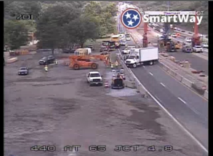
YIKES! Cars detouring into the construction zone around a truck stuck on I-440 EB in Berry Hill. Take Woodmont Blvd instead @WSMV #4WARN #traffic

We're getting you ready for your day on this #FridayEve! @mikecejka4 has the latest updates in your #4Warn forecast, just ahead on #News4 #Wakeup. Join us!

SOUTH/EAST NASHVILLE COMMUTERS... I-24 west by Shelby Ave. remains closed. Join me on @WSMV at 5am for alternate routes! #4WARN #traffic

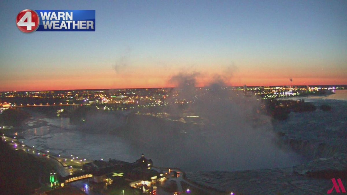
If it's going be a Monday, it might as well be pretty! Take a look at these shots, as the sun was coming up over #Buffalo and #NiagaraFalls! @mikecejka4 has your updated #4Warn forecast, just ahead on @news4buffalo #WakeUp! Hope you're with us this morning!


WOOOP WOOOP! Happy #HumpDay everyone! Join @Mel_Orlins, @mikecejka4 and me all morning on #WakeUp for the latest local headlines and your updated #4Warn forecast, which includes the potential for some #severe weather.
Happy #Friday! Your hair will be blowing in the breeze a bit today, as storms move through #WNY. @mikecejka4 is tracking your updated #4Warn forecast NOW on @news4buffalo #WakeUp! Hope you’re with us this morning!
Something went wrong.
Something went wrong.
United States Trends
- 1. Jokic N/A
- 2. Dort N/A
- 3. #SmackDown N/A
- 4. Cam Johnson N/A
- 5. Caruso N/A
- 6. Anthropic N/A
- 7. Shai N/A
- 8. Jamal Murray N/A
- 9. Chet N/A
- 10. Doris Burke N/A
- 11. Hardaway N/A
- 12. OpenAI N/A
- 13. Denver N/A
- 14. Nuggets N/A
- 15. Joker N/A
- 16. Cavs N/A
- 17. Jim Carrey N/A
- 18. #OPLive N/A
- 19. Rhea N/A
- 20. Flagrant 2 N/A