#utwx search results

National High/Low temps for Monday May 04, 2026: 102 at Rio Grande Village, TX; 15 at Peter Sinks, UT #txwx #utwx go.usa.gov/cu5tP

Unless you live above 7500 ft or so, you probably wont encounter ❄️ flakes unless you have high altitude travel plans. Wet 🌧️ weather is otherwise overspreading much of the area though, and an unsettled pattern will persist into the upcoming week. #utwx #wywx
Precipitation continues this afternoon across northern Utah along a stalled front. As this band weakens this evening and overnight, so will the precipitation. Primarily seeing mountain snow and valley rain, but received a report of rain mixing with snow in Daybreak. #utwx
National High/Low temps for Saturday May 02, 2026: 101 at 2 miles west-southwest of Cibola, AZ; 7 at Peter Sinks, UT #azwx #utwx go.usa.gov/cu5tP

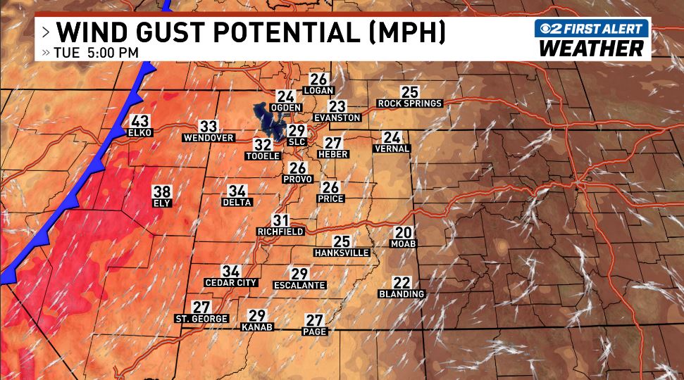
East downslope winds are increasingly likely Tuesday night into Wednesday morning. Gusts of 30-40 mph are expected north of I-80, with locally higher gusts up to 50 mph possible across Davis County. #utwx

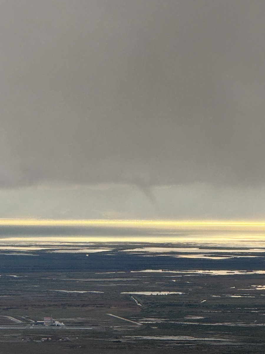
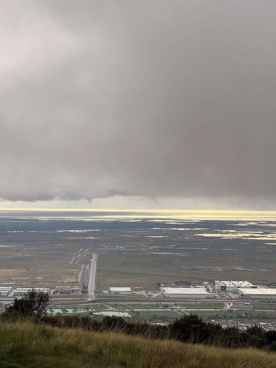
Hello Joshua! We received several reports of waterspouts at this location Sunday evening and have confirmed there were at least two waterspouts around 641 PM about 10 miles north of Lake Point. #utwx Thanks for your report! We appreciate it!

Possible water spouts over The Great Salt Lake at 6:41 PM tonight
National High/Low temps for Monday April 27, 2026: 106 at Rio Grande Village, TX; 2 at Peter Sinks, UT #txwx #utwx go.usa.gov/cu5tP
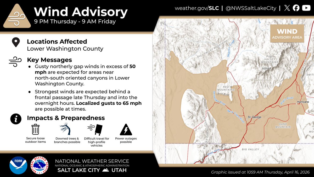
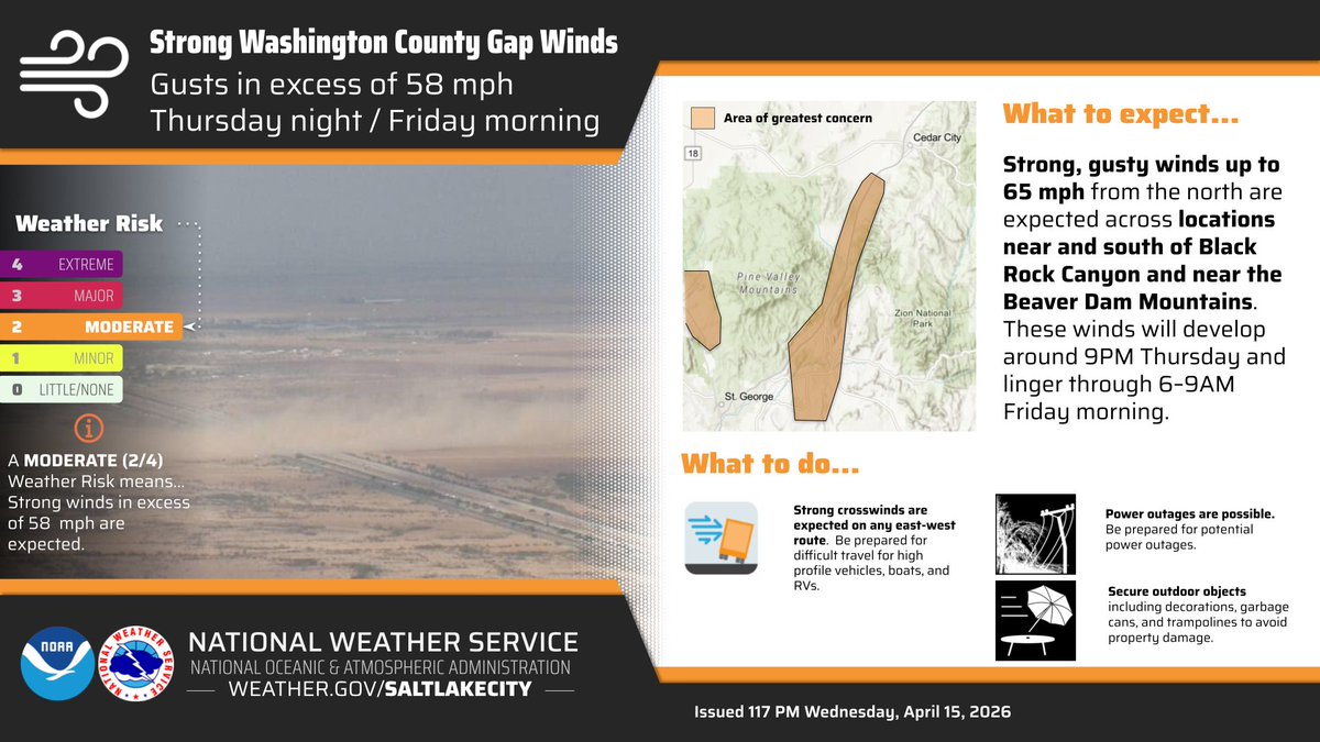
Strong northerly winds are expected tonight into Friday morning across portions of lower Washington County. Strongest winds are expected for locations near north-south oriented canyons, with gusts exceeding 50 mph. Ensure all loose outdoor items are secured. #utwx
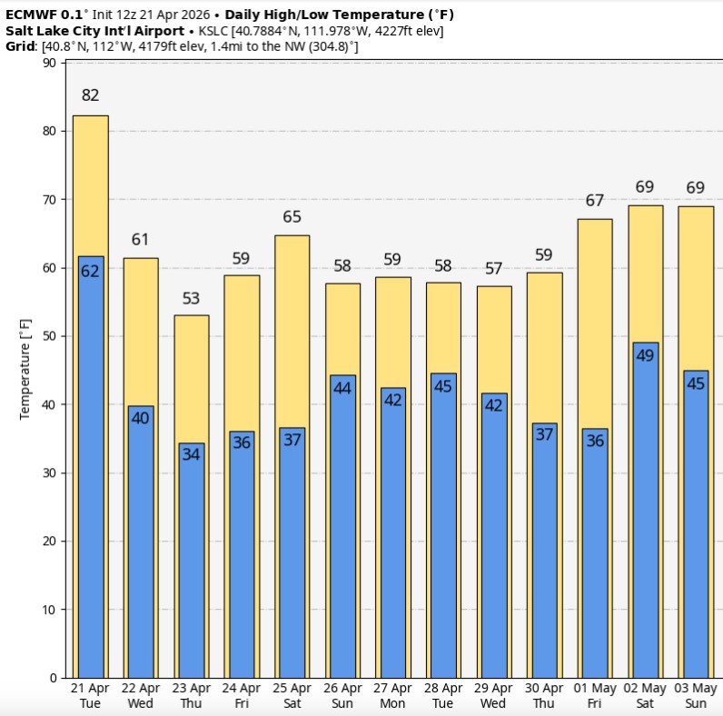
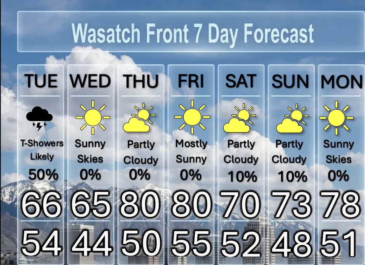
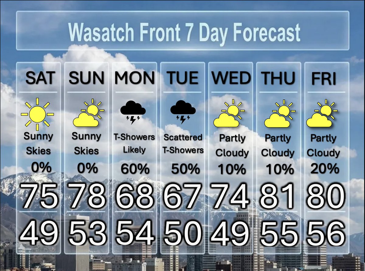
Enjoy it while it lasts—today looks like our final day in the 80s for a while. A cooler pattern settles in after this, with highs mostly in the 50s and 60s along the Wasatch Front over the next couple of weeks. #utwx
National High/Low temps for Friday May 01, 2026: 99 at 4 miles east of North Shore, CA, Death Valley, CA; 7 at Peter Sinks, UT #cawx #cawx #utwx go.usa.gov/cu5tP
A cold front tomorrow will bring the coldest overnight lows in a month or more, along with wind and and a brief burst of snow to valley floors. Snow forecast has trended downward as the front is moving faster, though there is still a lake effect snow threat Thurs night #utwx


A wide range of rain totals so far today. Southerly flow has kept Tooele and Salt Lake counties shadowed (<0.1" of rain), whereas areas along the northern Wasatch Front and Utah county are wetter (up to 1"). Filling in now across Salt Lake as winds switch to the northwest. #utwx

Strong southerly winds will increase across southeastern Utah during the day on Wednesday ahead of a cold front. Wind gusts up to 50 mph are expected. #utwx

National High/Low temps for Wednesday April 15, 2026: 98 at Rio Grande Village, TX; 14 at Berthoud Pass, CO, 22 miles southwest of Manila, UT #txwx #cowx #utwx go.usa.gov/cu5tP
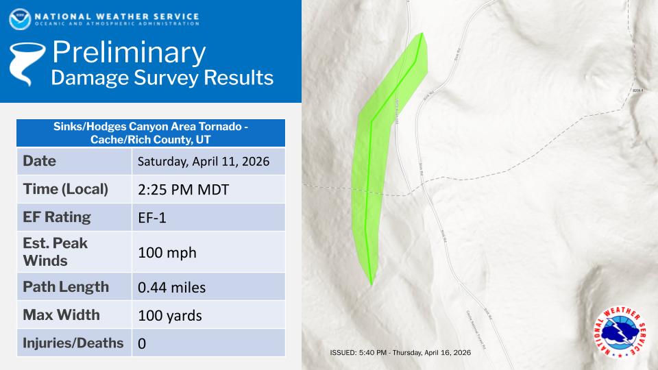
After conducting a damage survey, it was determined that a brief EF-1 tornado with estimated peak winds of 100 mph occurred 4/11 along the border of Rich County and Cache County near Sink Rd. and Hodges Canyon. Damage was limited to trees. #utwx. weather.gov/wrh/TextProduc…

A cold, fast moving storm system will bring accumulating snow to the mountains of northern Utah this afternoon, with a quick shot of valley snow as well. Precipitation will shift into central and southern Utah this evening. Here's what the radar might look like today. #utwx #wywx
National High/Low temps for Saturday April 18, 2026: 97 at 3 miles southeast of Horrel Hill, SC; -10 at Peter Sinks, UT #scwx #utwx go.usa.gov/cu5tP
⚠️Lake-effect showers have continued through much of the overnight hours, as seen on radar imagery below. Be sure to slow down if you drive through this lake band, as roads may have some slick spots. #utwx
National High/Low temps for Monday May 04, 2026: 102 at Rio Grande Village, TX; 15 at Peter Sinks, UT #txwx #utwx go.usa.gov/cu5tP
Storms over northern Utah and southwest Wyoming will be most numerous through the early evening, with any storms that develop capable of producing gusty winds in excess of 40 mph. Some showers will continue overnight and into Tuesday morning, primarily over NE Utah. #utwx #wywx


East downslope winds are increasingly likely Tuesday night into Wednesday morning. Gusts of 30-40 mph are expected north of I-80, with locally higher gusts up to 50 mph possible across Davis County. #utwx

A Few Thunderstorms, Then Nice May Weather We have a few thunderstorms forecast for this afternoon. Some with isolated microburst winds. Plan on more showers and thundershowers tomorrow, as a cold front moves through. Thereafter nice and mild. @weathercaster #utwx
Unsettled weather will occur as rounds of precip bring valley rain and mountain snow. Today, showers and storms will favor the northern half of the forecast area. A cold front then moves through Tue into Wed bringing more valley rain and snow for the higher terrain. #cowx #utwx

National High/Low temps for Sunday May 03, 2026: 100 at Death Valley, CA, Stovepipe Wells, CA; 10 at Peter Sinks, UT #cawx #cawx #utwx go.usa.gov/cu5tP
A collapsing thunderstorm is expected to bring strong, gusty winds as it moves through Rockville, Springdale, and the south end of Zion National Park. If outside at the park, find shelter! #utwx
A special weather statement has been issued for Apple Valley UT, Springdale UT and Rockville UT until 6:30 PM MDT

Storms Prancing Around, Then Dry And Pleasant Some moisture will move northward over the Wasatch Front tomorrow & Tuesday. Some microburst winds of 50+ mph possible on Monday. A slightly higher chance for measurable rain on Tuesday. Then nice weather. @DanPopeWeather #utwx
Rocky Mountain forecast Next up 5/4 L🌧️ GSL basin, 5/10 L Water supply 93% of median for Wasatch Front. #utwx #cowx #Idwx #wywx #SKI #Skiutah #skiIdaho #skicolorado #skiwyoming #nvwx #mtwx #CAwx #azwx youtube.com/watch?v=Ahb1i0…

youtube.com
YouTube
Chris Tomer
High-based showers and thunderstorms are expected to develop this afternoon across southern Utah. Given dry antecedent conditions, main concern remains for gusty and erratic outflow winds to 50 mph. #utwx
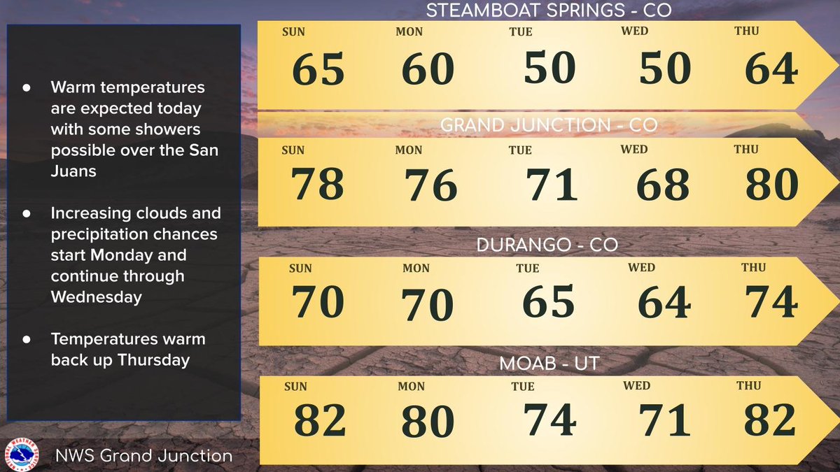
Warm temperatures continue today with a few showers possible over the San Juans this afternoon. Another round of showers will be possible Monday and Tuesday, favoring northern areas before more widespread precipitation moves in Tuesday night into Wednesday. #cowx #utwx
National High/Low temps for Saturday May 02, 2026: 101 at 2 miles west-southwest of Cibola, AZ; 7 at Peter Sinks, UT #azwx #utwx go.usa.gov/cu5tP
Rocky Mountain forecast Next up 5/4 L🌧️ GSL basin Water supply 93% of median for Wasatch Front communities. #utwx #cowx #Idwx #wywx #SKI #Skiutah #skiIdaho #skicolorado #skiwyoming #nvwx #mtwx #CAwx #azwx youtube.com/watch?v=Wm_ANE…

youtube.com
YouTube
Chris Tomer


A few showers/storms will be possible over the San Juans and isolated portions of the central mtns. Similar conditions are expected Sunday. Highs will warm up several degrees from those seen yesterday. A stronger system next week may bring more widespread precip. #cowx #utwx
National High/Low temps for Friday May 01, 2026: 99 at 4 miles east of North Shore, CA, Death Valley, CA; 7 at Peter Sinks, UT #cawx #cawx #utwx go.usa.gov/cu5tP
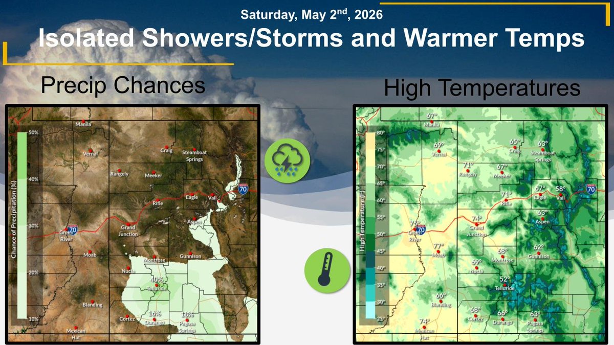
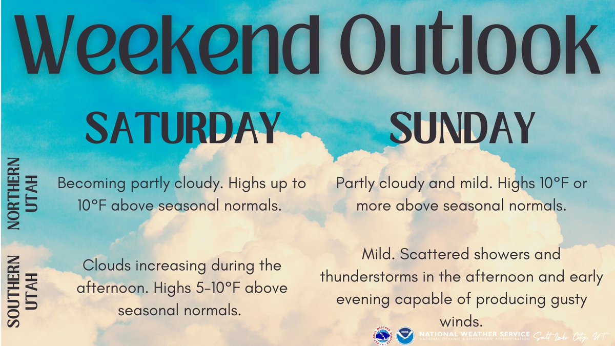
We'll be quite mild across the area this weekend, with highs around 10°F above seasonal normals for most of the area. Saturday will be dry, but some storms will develop over southern Utah beginning Sunday afternoon. Any storms that develop could produce gusty winds. #utwx

Gov. Cox warns this year "could be one of the worst wildfire seasons we've ever seen," and new fire outlooks seem to agree — until potential relief in August. Here's how El Niño could ultimately "make or break" the fire season #utwx: ksl.com/article/514918…

Beautiful Weekend, Then May Showers Ahead The beauty of May will shine this weekend, as temperatures rise into the mid to upper 70's; & the skies rain down abundant sunshine. Showers and afternoon thunderstorms develop Monday & Tuesday. Warmer later. @DanPopeWeather #utwx


East downslope winds are increasingly likely Tuesday night into Wednesday morning. Gusts of 30-40 mph are expected north of I-80, with locally higher gusts up to 50 mph possible across Davis County. #utwx
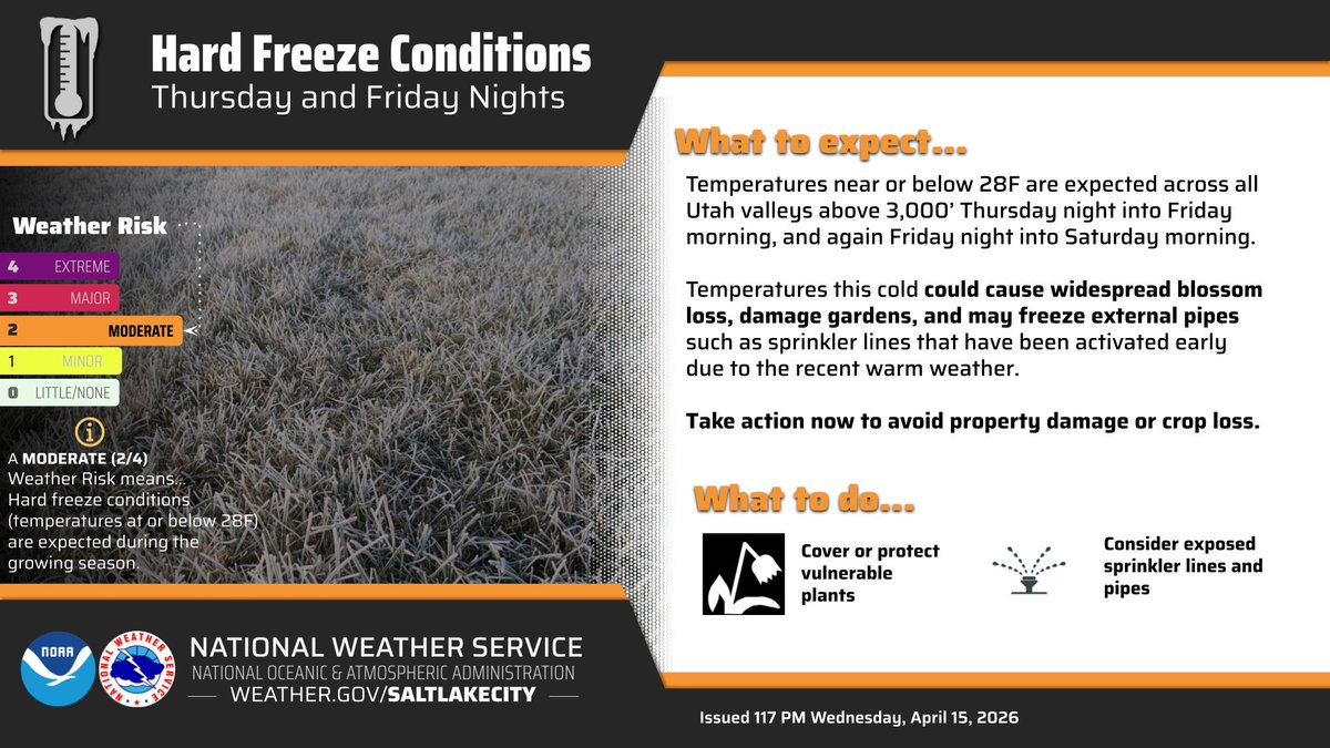
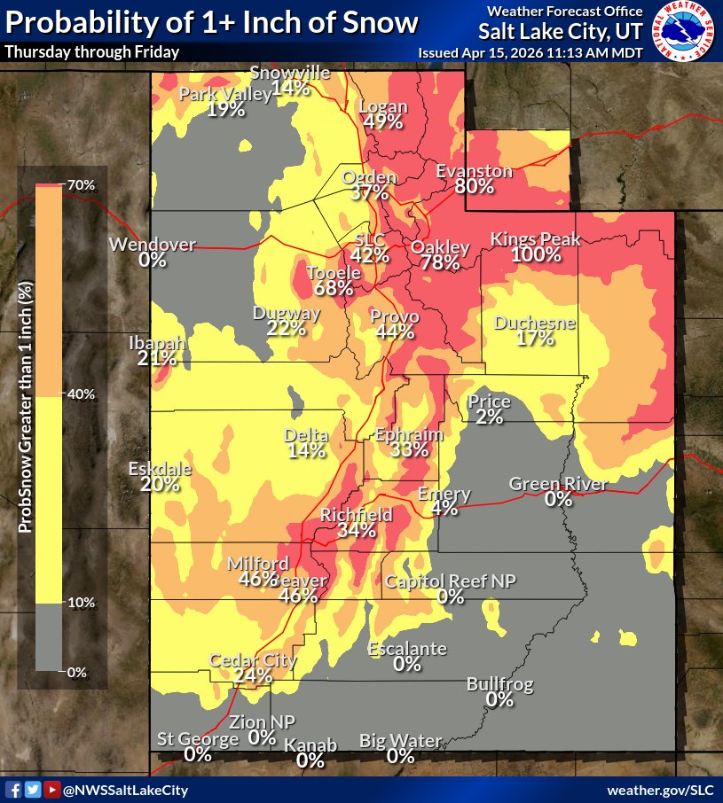
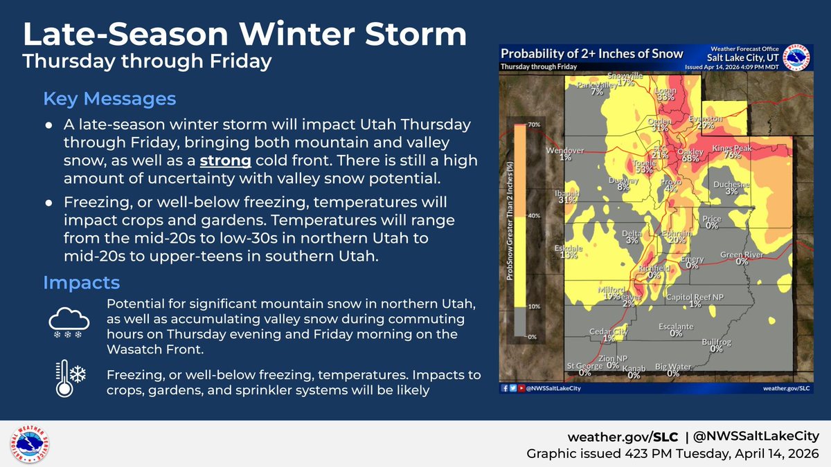
A late-season winter storm will move through the area from Thursday through Friday, bringing a variety of impacts ranging from mountain/ valley snowfall to freezing or below-freezing temperatures. Keep an eye on the forecast at weather.gov/slc #utwx #wywx
🔥💨 Wildfire smoke has cleared out nicely for a beautiful but warm Saturday in the Front Range! However, thicker but lofted smoke may briefly make a return Sunday morning compliments of the #LittleTwistFire in SW Utah which was a prescribed burn gone wrong! #COWx #UTwx


We'll be quite mild across the area this weekend, with highs around 10°F above seasonal normals for most of the area. Saturday will be dry, but some storms will develop over southern Utah beginning Sunday afternoon. Any storms that develop could produce gusty winds. #utwx
Strong northerly winds are expected tonight into Friday morning across portions of lower Washington County. Strongest winds are expected for locations near north-south oriented canyons, with gusts exceeding 50 mph. Ensure all loose outdoor items are secured. #utwx
After conducting a damage survey, it was determined that a brief EF-1 tornado with estimated peak winds of 100 mph occurred 4/11 along the border of Rich County and Cache County near Sink Rd. and Hodges Canyon. Damage was limited to trees. #utwx. weather.gov/wrh/TextProduc…
Strong southerly winds will increase across southeastern Utah during the day on Wednesday ahead of a cold front. Wind gusts up to 50 mph are expected. #utwx
Enjoy it while it lasts—today looks like our final day in the 80s for a while. A cooler pattern settles in after this, with highs mostly in the 50s and 60s along the Wasatch Front over the next couple of weeks. #utwx
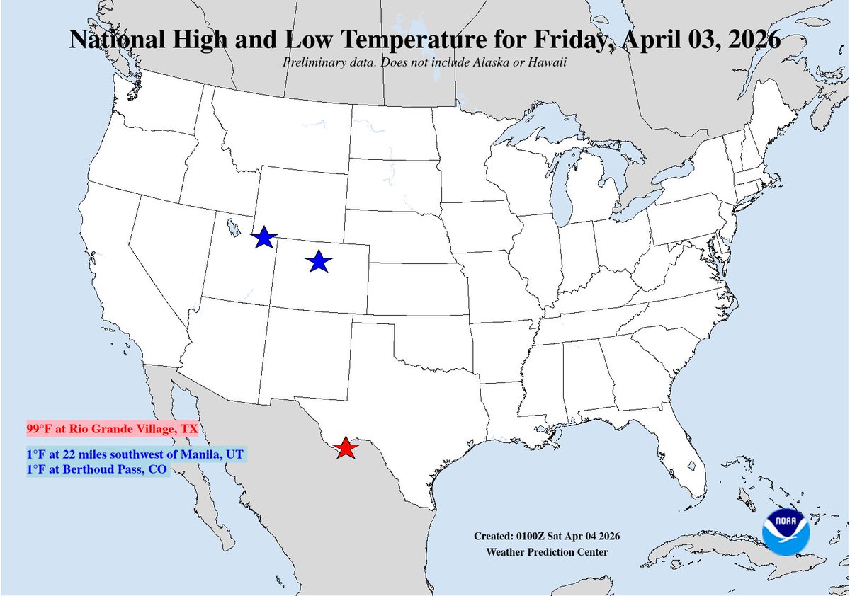
National High/Low temps for Friday April 03, 2026: 99 at Rio Grande Village, TX; 1 at 22 miles southwest of Manila, UT, Berthoud Pass, CO #txwx #utwx #cowx go.usa.gov/cu5tP
A cold front tomorrow will bring the coldest overnight lows in a month or more, along with wind and and a brief burst of snow to valley floors. Snow forecast has trended downward as the front is moving faster, though there is still a lake effect snow threat Thurs night #utwx
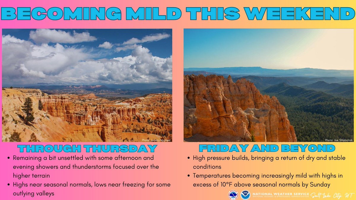
Conditions will stay a bit unsettled through Thursday with temperatures near seasonal normals. However, as high pressure builds in for the weekend, temperatures will becoming increasingly mild with dry conditions. #utwx #wywx
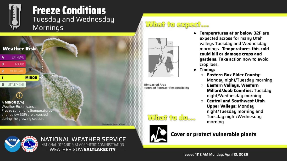
Many valleys across Utah will see freezing temperatures both Tuesday and Wednesday morning that could damage crops and gardens. Take action now to avoid crop loss. For more information about where and when the freezing temperatures will be, see the graphic. #utwx
WINDY WEEKEND: A lot of wind is in the forecast this weekend statewide. Southerly winds will gust around 25-40 mph each afternoon. This will be impactful if you have any outdoor plans. #utwx

A pair of storms will bring valley rain and mountain snow to all of Utah and SW Wyoming late this weekend into early next week. Snow in the mountains will be heaviest on Sunday morning. The highest rain/snow totals are expected across the northern half of Utah. #utwx #wywx

Heads up central and southwest Utah! Another round of freezing temperatures is expected tonight into Wednesday morning. Freezing, or sub-freezing, temperatures could kill or damage crops and gardens if left unmitigated #utwx

A wide range of rain totals so far today. Southerly flow has kept Tooele and Salt Lake counties shadowed (<0.1" of rain), whereas areas along the northern Wasatch Front and Utah county are wetter (up to 1"). Filling in now across Salt Lake as winds switch to the northwest. #utwx
Strong winds are expected across Utah on Tuesday and Wednesday. A cold front will move through the state Wednesday morning, bringing a sharp temperature drop of 20-25 degrees. #utwx
National High/Low temps for Monday April 06, 2026: 97 at Death Valley, CA; 6 at Peter Sinks, UT #cawx #utwx go.usa.gov/cu5tP

Something went wrong.
Something went wrong.
United States Trends
- 1. #MetGala N/A
- 2. #WWERaw N/A
- 3. Jalen Brunson N/A
- 4. #raindelayquestions N/A
- 5. Sol Ruca N/A
- 6. Beyoncé N/A
- 7. Blue Ivy N/A
- 8. Joe Hendry N/A
- 9. #AmericanIdol N/A
- 10. Star Wars N/A
- 11. Hack a Mitch N/A
- 12. Heidi Klum N/A
- 13. Bad Bunny N/A
- 14. #AlwaysKnicks N/A
- 15. Otis N/A
- 16. Fashion is Art N/A
- 17. Nick Nurse N/A
- 18. Seth Jarvis N/A
- 19. Blake Lively N/A
- 20. Michael Kay N/A