#cycloneimogen search results

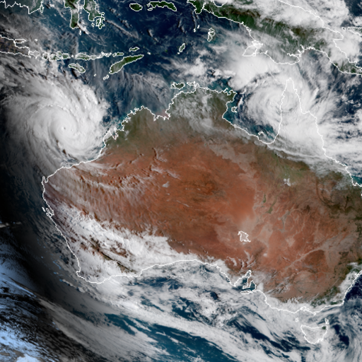
Tropical Cyclone Imogen is expected to make landfall just north of Karumba around midnight tonight. #CycloneImogen bom.gov.au/cyclone

#CycloneImogen will continue moving SE as a Cat 1 tropical cyclone, & cross the Gulf coast near #Karumba tonight. The developing system passed over Mornington Island today, where damaging winds & ~200mm of rain has been recorded since 9am. Cyclone info: ow.ly/8rJc50CYBAi


Tropical cyclone Imogen has recently crossed the coast just to the north of Karumba. #CycloneImogen bom.gov.au/cyclone

Tropical cyclone Imogen is moving further inland over the eastern Gulf Country. A transition to a tropical low is expected soon, but heavy rainfall and localised damaging winds remain possible. #CycloneImogen bom.gov.au/cyclone

Tropical #CycloneImogen's structure has changed, transitioning the system to a tropical low. Despite the name change, the rainfall is going to increase with widespread heavy rain & flooding expected. Damaging winds still possible with storms in the area. ow.ly/2qE150CYVR2

Barron Falls torrents tumble after #CycloneImogen system brought rainfall to Qld. Southeasterly wind surge moving thru SEQ will enhance rainfall for eastern parts in next 2-3 days as it merges w/ the tropical low. Thanks for vid Denali Wright. #QLDweather ow.ly/NjqH50D21Dv
Tropical cyclone Imogen has weakened to a tropical low but remains a dangerous system with widespread flooding rainfall expected over northern Queensland. See bom.gov.au/qld/warnings for the latest Qld severe weather and flood warnings. #CycloneImogen

The tropical low that was #CycloneImogen continues to bring heavy rainfall to northeastern parts of Queensland as it tracks slowly east over land. A Severe Weather Warning, Flood Watch and multiple flood warnings are current. See all #QLDweather warnings ow.ly/ClQr50CZZ7e


⚠️ #SevereWeatherWarning updated in #FNQ⚠️ Ex-Tropical #CycloneImogen will produce heavy rain & damaging/destructive winds across north #Qld. Warning area includes #Cairns #Townsville #PortDouglas #Mareeba #Ayr #Bowen #Georgetown #Croydon Warnings: ow.ly/M8Sv50CYYdg

NOAA pass 7:33am #CycloneImogen #Cairns #Fnq is closer than I thought at this time today. Say safe people.


⚠️Minor to moderate flooding is expected in North Tropical Coast catchments from today as Ex-Tropical #CycloneImogen moves into the region. Major flooding possible in areas of heaviest rain. Follow @QldFES advice & check out the #Flood Watch & Warnings: ow.ly/XrO250CYZcQ

BTW Before this animation starts the low (Invest #27S) is expected to strengthen to a cat 1 tropical cyclone potenitally impacting Cocos Island. If it does reach TC strength it will be named #CycloneImogen


Ex-tropical #CycloneImogen and a coastal trough are triggering heavy showers and #thunderstorms for #Qld's northeast and central tropics. A number of #flood warnings are current, so make sure you keep up to date with the latest at ow.ly/lEFF50D21wl


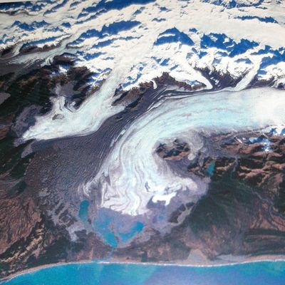
Even though the rain event from #cycloneImogen has passed, at #Undara #NationalPark the water table is so full that it is continuing to rain inside the volcanic lava tubes! This is a once-in-a-decade event. Ewamin Cave photo courtesy of Ranger David Gutry.


As the soggy north of the state dries out ☀️ following #cycloneimogen our rangers are sharing incredible photos. This is Ewamin Cave, at #Undara Volcanic National Park, dry in 2018, and underwater now. #lavatubes #volcaniccaves 📷David Gutry. #nationalpark #nature #photography


| #Imogen #CycloneImogen #hurricane #cyclone #barronfalls #QldWeather #qldwx #Queensland #Queenslandwx
Barron Falls torrents tumble after #CycloneImogen system brought rainfall to Qld. Southeasterly wind surge moving thru SEQ will enhance rainfall for eastern parts in next 2-3 days as it merges w/ the tropical low. Thanks for vid Denali Wright. #QLDweather ow.ly/NjqH50D21Dv

Ex-tropical cyclone Imogen continues to lash North Queensland - watch out - Imogen continues to rage... 👍😁 Winds, water and a bit more reason to be cautious...mind your step, coming through. #auspol #qldpol #CycloneImogen theaustralian.com.au/breaking-news/…

That's a lot of rain! AND more is expected across much of Queensland. Continue to monitor @BOM_Qld for updates and visit bom.gov.au/qld/warnings/ for latest BOM warnings and flood levels. Stay safe, stay dry and stay out of flooded roadways! #QldWeather #CycloneImogen
Barron Falls torrents tumble after #CycloneImogen system brought rainfall to Qld. Southeasterly wind surge moving thru SEQ will enhance rainfall for eastern parts in next 2-3 days as it merges w/ the tropical low. Thanks for vid Denali Wright. #QLDweather ow.ly/NjqH50D21Dv

BOM_Qld: Barron Falls torrents tumble after #CycloneImogen system brought rainfall to Qld. Southeasterly wind surge moving thru SEQ will enhance rainfall for eastern parts in next 2-3 days as it merges w/ the tropical low. Thanks for vid Denali Wright. #…
Barron Falls torrents tumble after #CycloneImogen system brought rainfall to Qld. Southeasterly wind surge moving thru SEQ will enhance rainfall for eastern parts in next 2-3 days as it merges w/ the tropical low. Thanks for vid Denali Wright. #QLDweather ow.ly/NjqH50D21Dv
Ex-tropical #CycloneImogen and a coastal trough are triggering heavy showers and #thunderstorms for #Qld's northeast and central tropics. A number of #flood warnings are current, so make sure you keep up to date with the latest at ow.ly/lEFF50D21wl
Ex-Tropical #CycloneImogen continues to produce heavy rainfall across the tropical north east #Qld coast; the satellite shows that it's still rotating under that mass of cloud 🌧️ More rain to come, and #flood warnings are still current - ow.ly/qN7f50D1Yen

#CycloneImogen: Downgraded storm brings flood warnings to Queensland. #Imogen #Australia bbc.co.uk/news/av/world-…

Tafrishaala Prime Time #Queensland #Australia #CycloneImogen #flood #SerumInstituteofIndia #BharatBiotech #vaccines #lockdown #COVID19 #Britain #londonlockdown #Qatar #Gulf #SaudiArabia #Summit #SriLanka #VaccineStrategy #COVAX #unitednations #tafrishaala #primetime #worldnews

Dangerous flooding in wake of #CycloneImogen for north Queensland as heavy rains lash Victoria and NSW theguardian.com/australia-news…

My brother-in-law filmed this earlier today near his home in Townsville, Queensland. Shortly afterwards the bridge in the video was totally submerged. Welcome to the wet season with added #cycloneimogen. #rain #fnq #weather #Townsville

Now is the time to talk to children about the dangers of playing in or near floodwater. ⭕Never play in or near floodwater. ⭕Look out for friends. #QLDWeather #cycloneimogen
Life-threatening flash flooding and locally destructive winds could result from the intense weather impacting northeast Queensland. Six-hourly rainfall totals could be up to 150-200mm with 300mm possible in some areas. Follow advice of @QldFES. #QLDweather ow.ly/L9OX50D00Rf


#CycloneImogen causing massive flooding in North #Queensland | @DailyMailAU #Australia dailymail.co.uk/news/article-9…

#CYCLONEIMOGEN: A Severe Weather Warning, Flood Watch and multiple flood warnings are in place for North Queensland, as Cyclone Imogen continues to bring heavy rainfall as it tracks slowly east over land. @BOM_Qld More details: 9Soci.al/M5CE30rrhj1 #9News
BOM_Qld: The tropical low that was #CycloneImogen continues to bring heavy rainfall to northeastern parts of Queensland as it tracks slowly east over land. A Severe Weather Warning, Flood Watch and multiple flood warnings are current. See all #QLDweather…
Tropical Cyclone Imogen is expected to make landfall just north of Karumba around midnight tonight. #CycloneImogen bom.gov.au/cyclone
#CycloneImogen will continue moving SE as a Cat 1 tropical cyclone, & cross the Gulf coast near #Karumba tonight. The developing system passed over Mornington Island today, where damaging winds & ~200mm of rain has been recorded since 9am. Cyclone info: ow.ly/8rJc50CYBAi
Tropical cyclone Imogen has recently crossed the coast just to the north of Karumba. #CycloneImogen bom.gov.au/cyclone
⚠️ #SevereWeatherWarning updated in #FNQ⚠️ Ex-Tropical #CycloneImogen will produce heavy rain & damaging/destructive winds across north #Qld. Warning area includes #Cairns #Townsville #PortDouglas #Mareeba #Ayr #Bowen #Georgetown #Croydon Warnings: ow.ly/M8Sv50CYYdg
Tropical cyclone Imogen is moving further inland over the eastern Gulf Country. A transition to a tropical low is expected soon, but heavy rainfall and localised damaging winds remain possible. #CycloneImogen bom.gov.au/cyclone
Tropical #CycloneImogen's structure has changed, transitioning the system to a tropical low. Despite the name change, the rainfall is going to increase with widespread heavy rain & flooding expected. Damaging winds still possible with storms in the area. ow.ly/2qE150CYVR2
NOAA pass 7:33am #CycloneImogen #Cairns #Fnq is closer than I thought at this time today. Say safe people.
Tropical cyclone Imogen has weakened to a tropical low but remains a dangerous system with widespread flooding rainfall expected over northern Queensland. See bom.gov.au/qld/warnings for the latest Qld severe weather and flood warnings. #CycloneImogen
Meteor M2 pass, low pass but can just see the cloud cover covering fnq. Will post another today at 10:30am #Cairns #Fnq #CycloneImogen

⚠️Minor to moderate flooding is expected in North Tropical Coast catchments from today as Ex-Tropical #CycloneImogen moves into the region. Major flooding possible in areas of heaviest rain. Follow @QldFES advice & check out the #Flood Watch & Warnings: ow.ly/XrO250CYZcQ
Ex-tropical #CycloneImogen and a coastal trough are triggering heavy showers and #thunderstorms for #Qld's northeast and central tropics. A number of #flood warnings are current, so make sure you keep up to date with the latest at ow.ly/lEFF50D21wl
Well looks like we may have gotten lucky as the low is moving south, though maybe have some this afternoon but will be end #cairns #cycloneimogen #fnq

#CycloneImogen #Fnq #Cairns last satellite pass will post regarding Cyclone Imogen cat1 unless things get worse. My aim is to help people who wanted information on this I hope I’ve helped someone. If rain trough becomes worse will post


BTW Before this animation starts the low (Invest #27S) is expected to strengthen to a cat 1 tropical cyclone potenitally impacting Cocos Island. If it does reach TC strength it will be named #CycloneImogen
Something went wrong.
Something went wrong.
United States Trends
- 1. Good Thursday 28.7K posts
- 2. Cynthia 56.9K posts
- 3. #GrabFoodMegaSalexหลิงออม 435K posts
- 4. #WorldKindnessDay 8,818 posts
- 5. Larry Brooks N/A
- 6. Rejoice in the Lord 2,319 posts
- 7. SUSDT N/A
- 8. #SwiftDay N/A
- 9. RIP Brooksie N/A
- 10. Happy Friday Eve N/A
- 11. PancakeSwap BNB Chain N/A
- 12. #thursdaymotivation 1,926 posts
- 13. RIP Larry N/A
- 14. #thursdayvibes 2,610 posts
- 15. Michael Burry 7,407 posts
- 16. Namjoon 104K posts
- 17. Jesse Jackson 1,426 posts
- 18. Jeffrey Epstein 519K posts
- 19. Eddie Guerrero 3,848 posts
- 20. Mikey 54.2K posts