#firemap search results

Get inspired by our latest Developer Spotlight with Tristan Morris, creator of Bushfire.io. Watch on our Youtube channel: buff.ly/43rdclp 🔥 🗺️ #BuiltWithMapbox #weathermaps #firemap #hazardmap

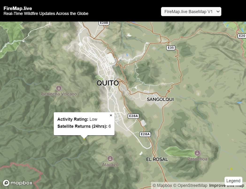
El proyecto #Firemap de @unileon, presentado en los #TalleresCDFsobre tecnología, pone al alcance de gestores forestales, administraciones públicas, servicios de emergencia y comunidades locales análisis satelitales sin necesidad de conocimientos técnicos previos

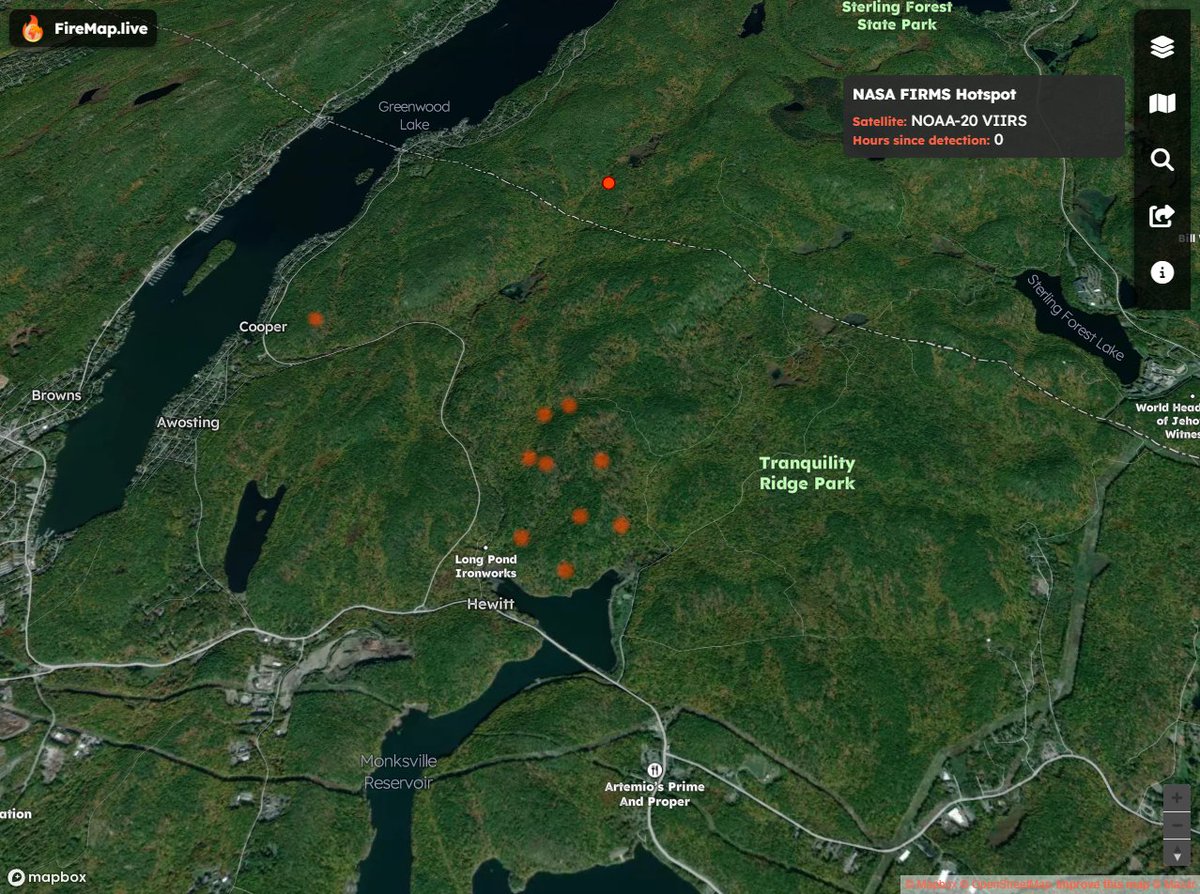
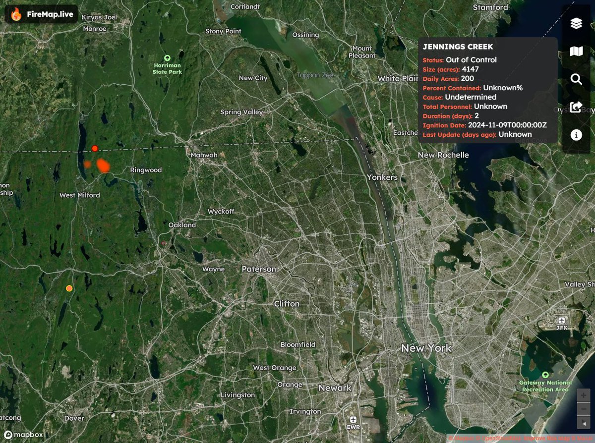
Here's the location of the Jennings Creek Fire on the New York-New Jersey border. Map shows proximity to New York. Stay tuned to #FireMap for data updates. firemap.live/?lng=-74.30245…

The Jennings Creek wildfire has now scorched more than 5,000 acres along the New York-New Jersey border. @trevorlault has the latest on the blaze.
See the latest burned area boundaries on #FireMap x.com/disaster_db/st…
#MountainFire Map Update: Now at 19,643 Acres Check FireMap.live for the latest boundaries, satellite hotspots for #MountainFire. Stay informed and follow evacuation orders as conditions change. #MountainFire #VenturaCounty #SantaPaula
We are starting to see a few satellite, hotspots on #FireMap for #MountainFire. Safe to say this one is going to cover a significant area is in the region evacuate to be on the safe side.

⚠️UPDATE⚠️The fire has jumped SR-118 west of Somis and there are now MANDATORY evacuations south of SR-118. Check vcemergency.com for up to the minute details on the #MountainFire.
For those looking for real-time mapping updates... see #FireMap and stay safe! x.com/disaster_db/st…
Tracking the Pacific Palisades Fire 🔥 Neal-time satellite hotspots and burned area boundaries on FireMap #PacificPalisadesFire
Thank you for your efforts @VCFD_PIO. Burned area boundaries and satellite hotspots can be found on #FireMap firemap.live/?lng=-119.0048…


Check out our #FireMap, created to provide a general awareness of wildfire activity. We're sharing this map solely as a reference. If you're near a fire or feel that you are at risk, please contact your local authorities for information. #ParkFire #CAwx ucanr.edu/sites/fire/Saf…
ucanr.edu
Fire Activity Map | UC ANR Fire Network
This map is an independent community effort developed to provide a general awareness of wildfire activity. UCANR is sharing this map solely as a reference, and is not responsible for the content or...
The #Parkfire in Butte County has now surpassed 164,000 acres. Take a moment to watch this powerful video and consider how you and your family are prepared for the threat of wildfire. For more information on the Park Fire visit: fire.ca.gov/incidents/2024…
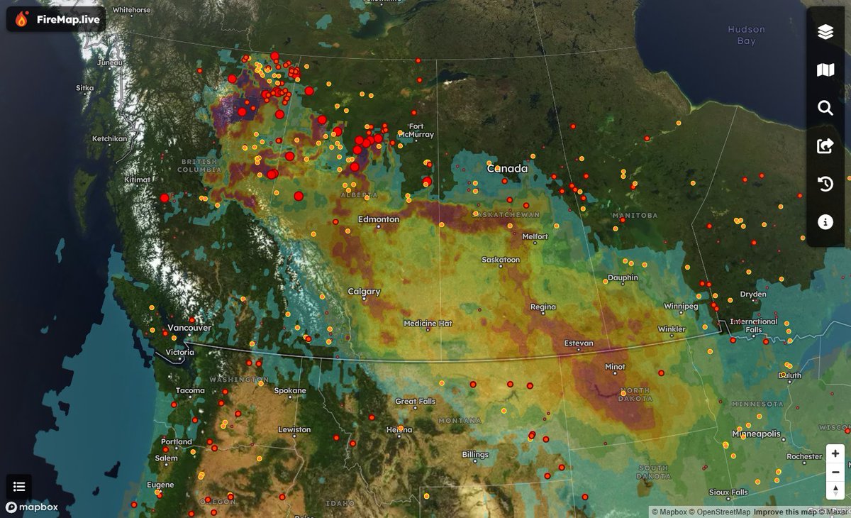
Curious about the smoke's source? Wildfires in Alberta and NE BC are causing heavy smoke in Calgary, Edmonton, the Prairies, and ND. Lighter smoke drifts east toward Toronto and Chicago. Conditions should improve by Friday. View hourly smoke model updates on #FireMap🌎🌬️
@AlbertaWildfire burned area boundaries are on #FireMap. Stay safe! x.com/disaster_db/st…
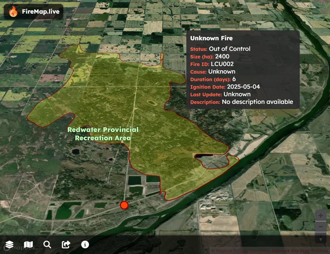
Wildfire north of Edmonton remains a threat: 56 homes evacuated near #Redwater Provincial Recreation Area, per Sturgeon County Fire Chief Chad Moore. Perimeter mapping live on FireMap; crews tightening control but “not out of the woods yet.”

I’m also trying to get an updated #firemap of the #Palisades fire for family in that area. Wishing we could get more up to date info.

🚨 Palisades Fire Expands to 15,832 Acres Today, the Palisades Fire has pushed west into Tuna Canyon en route to Malibu, now burning 15,832 acres. Check out #FireMap for real-time satellite hotspots and track the fire’s movement. More boundary updates coming soon—stay informed
Check out our #FireMap to locate fires in your area. ucanr.edu/sites/fire/Saf… #CAwx #MaxFire
ucanr.edu
Fire Activity Map | UC ANR Fire Network
This map is an independent community effort developed to provide a general awareness of wildfire activity. UCANR is sharing this map solely as a reference, and is not responsible for the content or...

New Fire: #MaxFire near 80th Street West, Lancaster in Los Angeles County is 337 acres. @LACOFD fire.ca.gov/incidents/2024…
🔥 #FranklinFire Mapping Update: 4,037 Acres Burned View our new 3D map on #FireMap. Satellite Hotspots are down, and we’re approaching final containment efforts. Stay safe, and thank you to all the crews working tirelessly. #MalibuFires #MalibuWildfire
Usually its the parking lot that takes out nature, now nature is taking out a parking lot. See the location of this eruption on #FireMap #BlueLagoon #IcelandVolcano firemap.live/?lng=-22.41162…


WATCH: Lava flows into Blue Lagoon car parking lot, destroys building after Iceland volcano erupts again
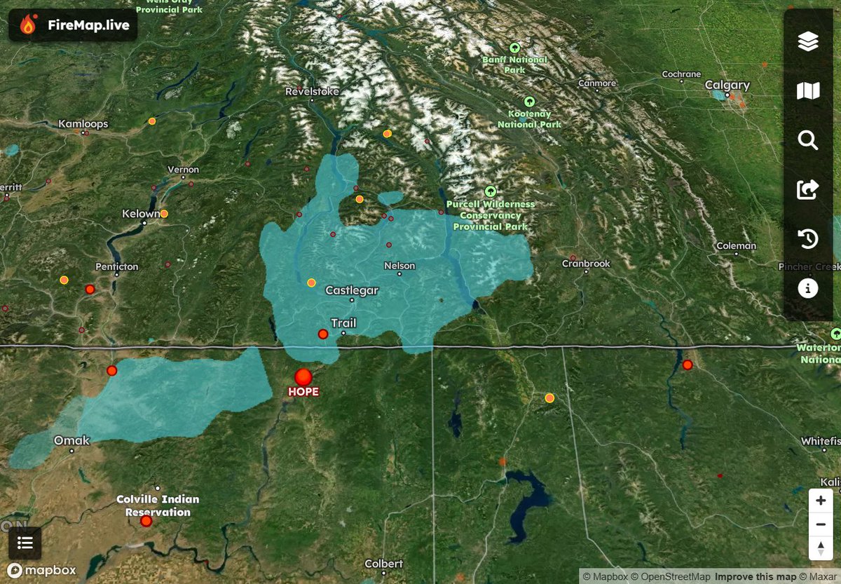
FireMap’s hourly updated ground model shows low #HopeFire smoke in Trail, Castlegar, Nelson, BC. CAD/US wildfire & smoke data in one map highlights smoke’s borderless spread. 🇨🇦🇺🇸 #FireMap

In 2025 alone, InformNapalm’s interactive Fire Map 🔥 has logged 90+ strikes on Russian oil refineries - vs ~130 in all of 2022-24 combined. And there are still 3 months left this year. 🗺️ google.com/maps/d/u/0/vie… #OSINT #FireMap #Russia


Does anyone have an accurate #firemap of the #Palisades #PalisadeFire? A very close friend’s mom is in the Ciela nursing home - they did not evacuate them but sheltered in place. My friend is desperately trying to reach her. Thank you (and prayers to all the first responders). 😔
El proyecto #Firemap de @unileon, presentado en los #TalleresCDFsobre tecnología, pone al alcance de gestores forestales, administraciones públicas, servicios de emergencia y comunidades locales análisis satelitales sin necesidad de conocimientos técnicos previos

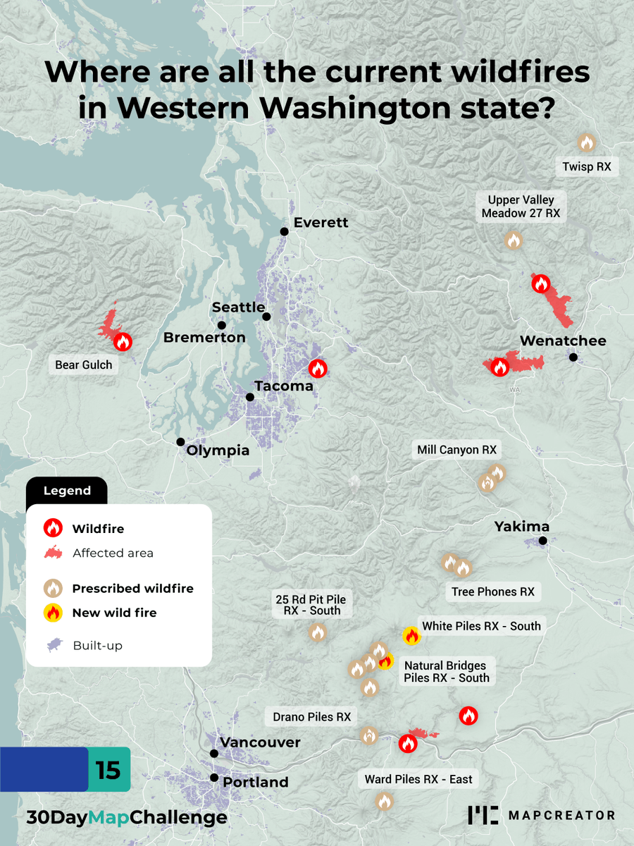
Want to know where all the wildfires in Washington are? Our mapping tool gives you easy access to live wildfire coverage 🚒 #firemap #wildfires #30daymapchallenge
In 2025 alone, InformNapalm’s interactive Fire Map 🔥 has logged 90+ strikes on Russian oil refineries - vs ~130 in all of 2022-24 combined. And there are still 3 months left this year. 🗺️ google.com/maps/d/u/0/vie… #OSINT #FireMap #Russia
FireMap’s hourly updated ground model shows low #HopeFire smoke in Trail, Castlegar, Nelson, BC. CAD/US wildfire & smoke data in one map highlights smoke’s borderless spread. 🇨🇦🇺🇸 #FireMap
Curious about the smoke's source? Wildfires in Alberta and NE BC are causing heavy smoke in Calgary, Edmonton, the Prairies, and ND. Lighter smoke drifts east toward Toronto and Chicago. Conditions should improve by Friday. View hourly smoke model updates on #FireMap🌎🌬️

FireMap is developing real-time wildfire smoke intelligence, launching soon.

@AlbertaWildfire burned area boundaries are on #FireMap. Stay safe! x.com/disaster_db/st…
Wildfire north of Edmonton remains a threat: 56 homes evacuated near #Redwater Provincial Recreation Area, per Sturgeon County Fire Chief Chad Moore. Perimeter mapping live on FireMap; crews tightening control but “not out of the woods yet.”
Thank you @CityofSSF for attending tonight’s Town Hall with @SSFFire Great turnout and questions! #FireMap #Awareness @SSFCERT_PIO @CALFIRECZU


Palisades fire Map #PalisadesFire #firemap #palisades #pacificpalisades firemap.live/?lng=-118.4886…

Le dimensioni degli incendi che ci stanno preoccupando e di quelli che continuiamo ad ignorare #FireMap @NASA #wildfire

View the latest burned area boundary in 3D on #FireMap. Stay safe everyone! x.com/disaster_db/st…
🚨 Palisades Fire Expands to 15,832 Acres Today, the Palisades Fire has pushed west into Tuna Canyon en route to Malibu, now burning 15,832 acres. Check out #FireMap for real-time satellite hotspots and track the fire’s movement. More boundary updates coming soon—stay informed
🚨 Palisades Fire Expands to 15,832 Acres Today, the Palisades Fire has pushed west into Tuna Canyon en route to Malibu, now burning 15,832 acres. Check out #FireMap for real-time satellite hotspots and track the fire’s movement. More boundary updates coming soon—stay informed


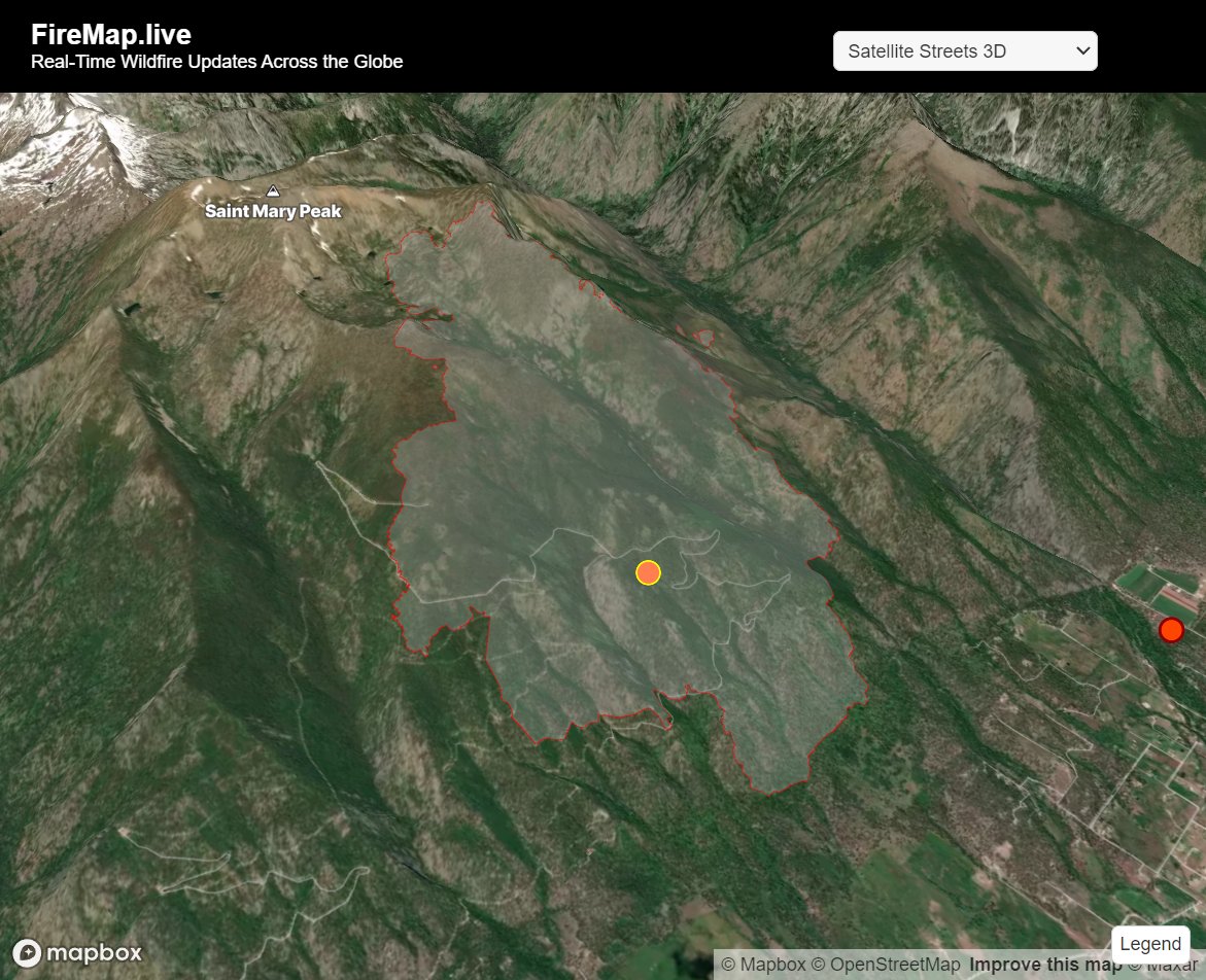
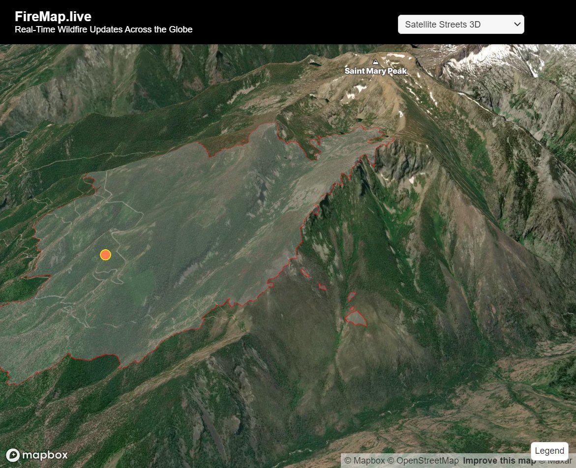
It looks like some steep terrain according to #FireMap. Stay safe! #SharrottCreekFire #StevensvilleMT #MTwx #MTFires @NWSMissoula @BitterrootNF
We are starting to see a few satellite, hotspots on #FireMap for #MountainFire. Safe to say this one is going to cover a significant area is in the region evacuate to be on the safe side.
⚠️UPDATE⚠️The fire has jumped SR-118 west of Somis and there are now MANDATORY evacuations south of SR-118. Check vcemergency.com for up to the minute details on the #MountainFire.
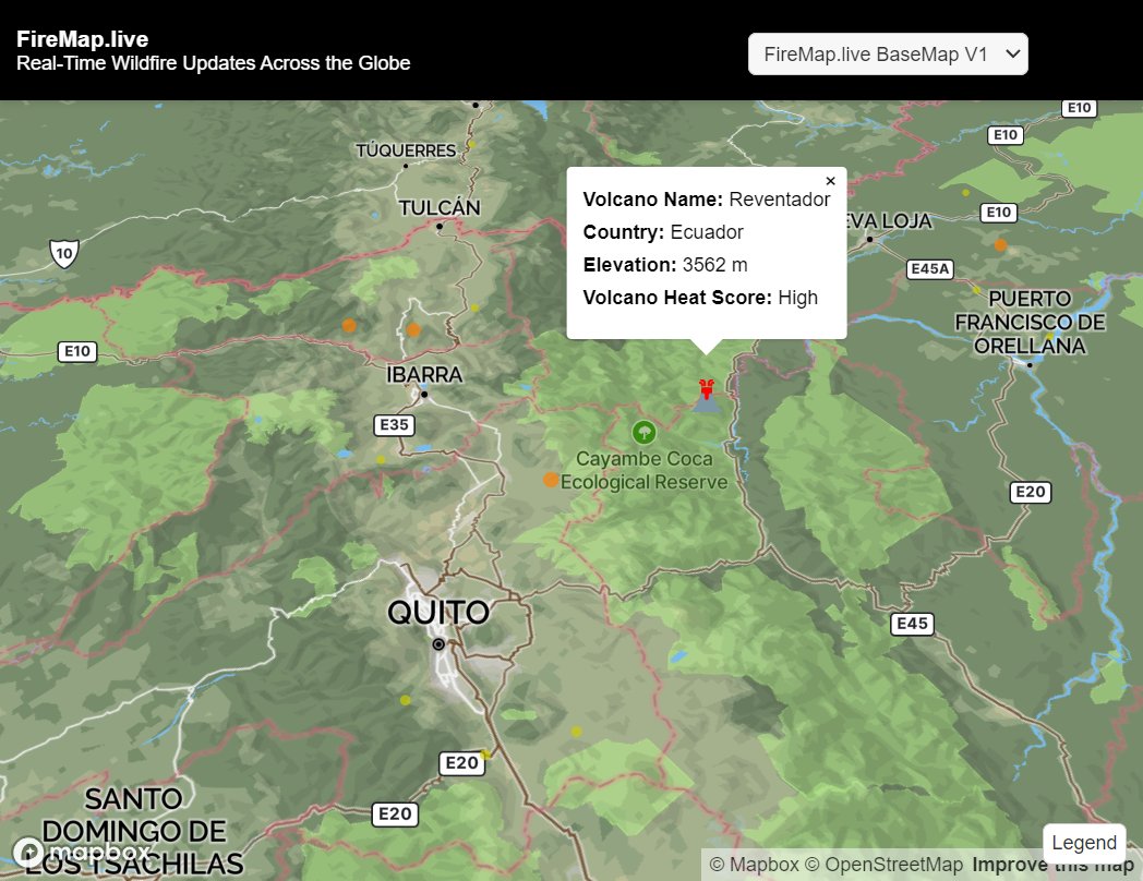
Yikes, our near-time hotspot detection is picking up some heat signatures here and this lines up with report. Stay tuned to #FireMap for updates (we have 🌋 stuff too!)
In 2025 alone, InformNapalm’s interactive Fire Map 🔥 has logged 90+ strikes on Russian oil refineries - vs ~130 in all of 2022-24 combined. And there are still 3 months left this year. 🗺️ google.com/maps/d/u/0/vie… #OSINT #FireMap #Russia

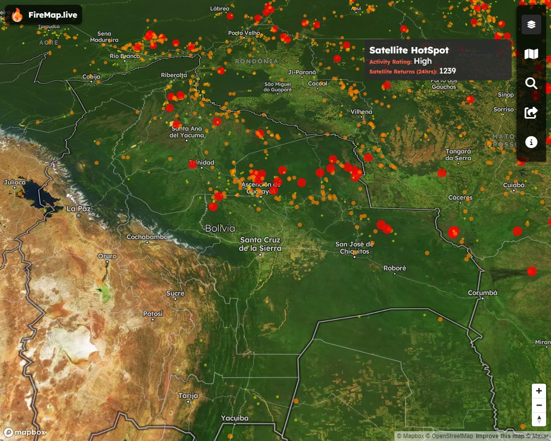
Africa, the “fire continent!” Below is NASA's fire map for Africa over the last 7 days! Did you know that at least 70% of the 10,000 fires burning worldwide on an average August day are in Africa? lnkd.in/dmiEc-9j #africa #nasa #firemap

Want to know where all the wildfires in Washington are? Our mapping tool gives you easy access to live wildfire coverage 🚒 #firemap #wildfires #30daymapchallenge
Curious about the smoke's source? Wildfires in Alberta and NE BC are causing heavy smoke in Calgary, Edmonton, the Prairies, and ND. Lighter smoke drifts east toward Toronto and Chicago. Conditions should improve by Friday. View hourly smoke model updates on #FireMap🌎🌬️
Waipara wildfire showing 36 satellite heat signature returns in the last 24 hours #NewZealand #FireMap

Usually its the parking lot that takes out nature, now nature is taking out a parking lot. See the location of this eruption on #FireMap #BlueLagoon #IcelandVolcano firemap.live/?lng=-22.41162…
WATCH: Lava flows into Blue Lagoon car parking lot, destroys building after Iceland volcano erupts again
Thank you for your efforts @VCFD_PIO. Burned area boundaries and satellite hotspots can be found on #FireMap firemap.live/?lng=-119.0048…
Here's the location of the Jennings Creek Fire on the New York-New Jersey border. Map shows proximity to New York. Stay tuned to #FireMap for data updates. firemap.live/?lng=-74.30245…
The Jennings Creek wildfire has now scorched more than 5,000 acres along the New York-New Jersey border. @trevorlault has the latest on the blaze.
Le dimensioni degli incendi che ci stanno preoccupando e di quelli che continuiamo ad ignorare #FireMap @NASA #wildfire
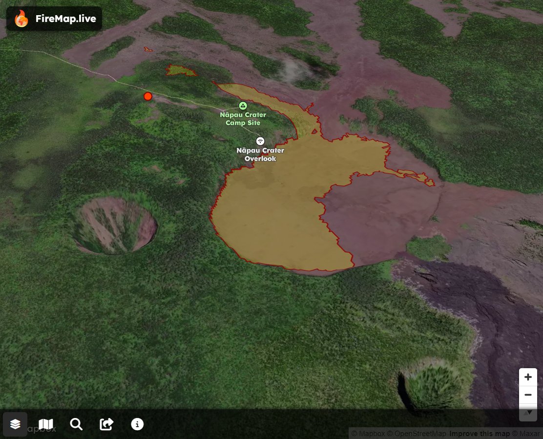
Check out the latest lava flow outlines for the Nāpau Crater eruption on #FireMap firemap.live/?lng=-155.1466…


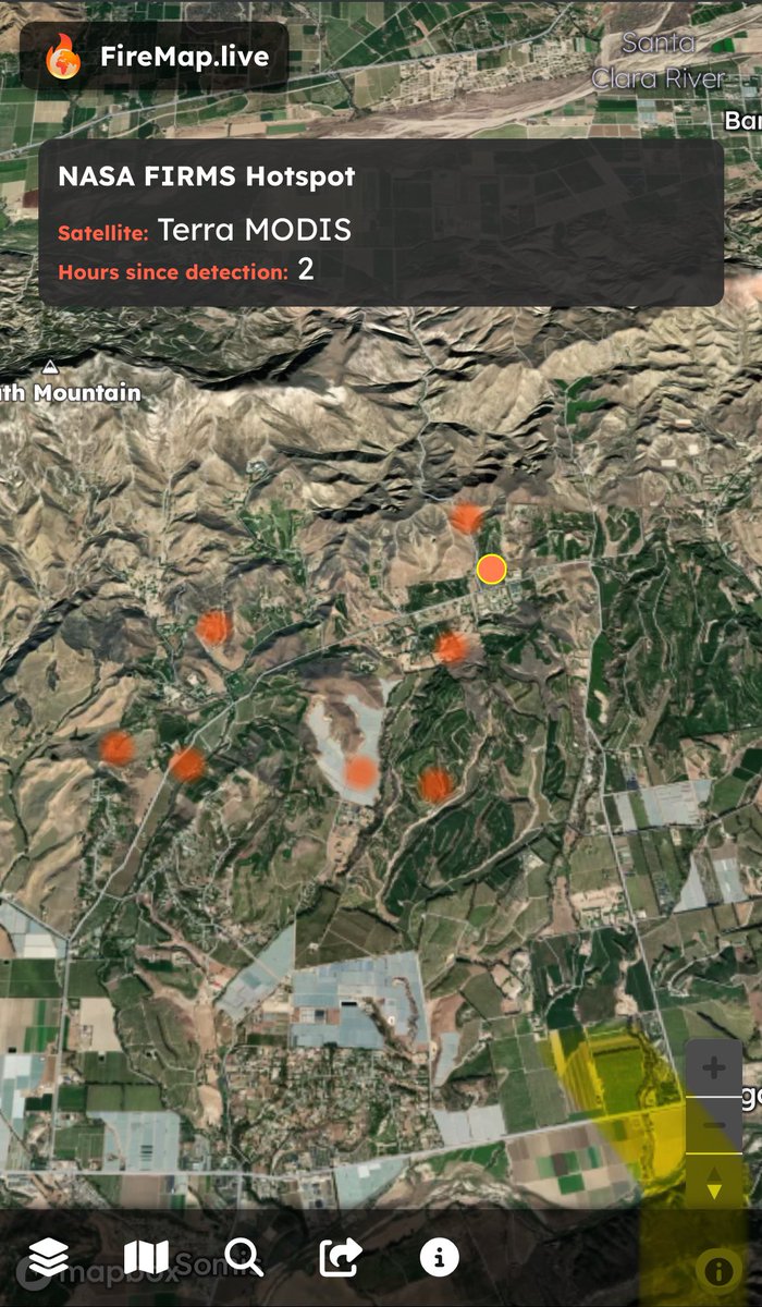
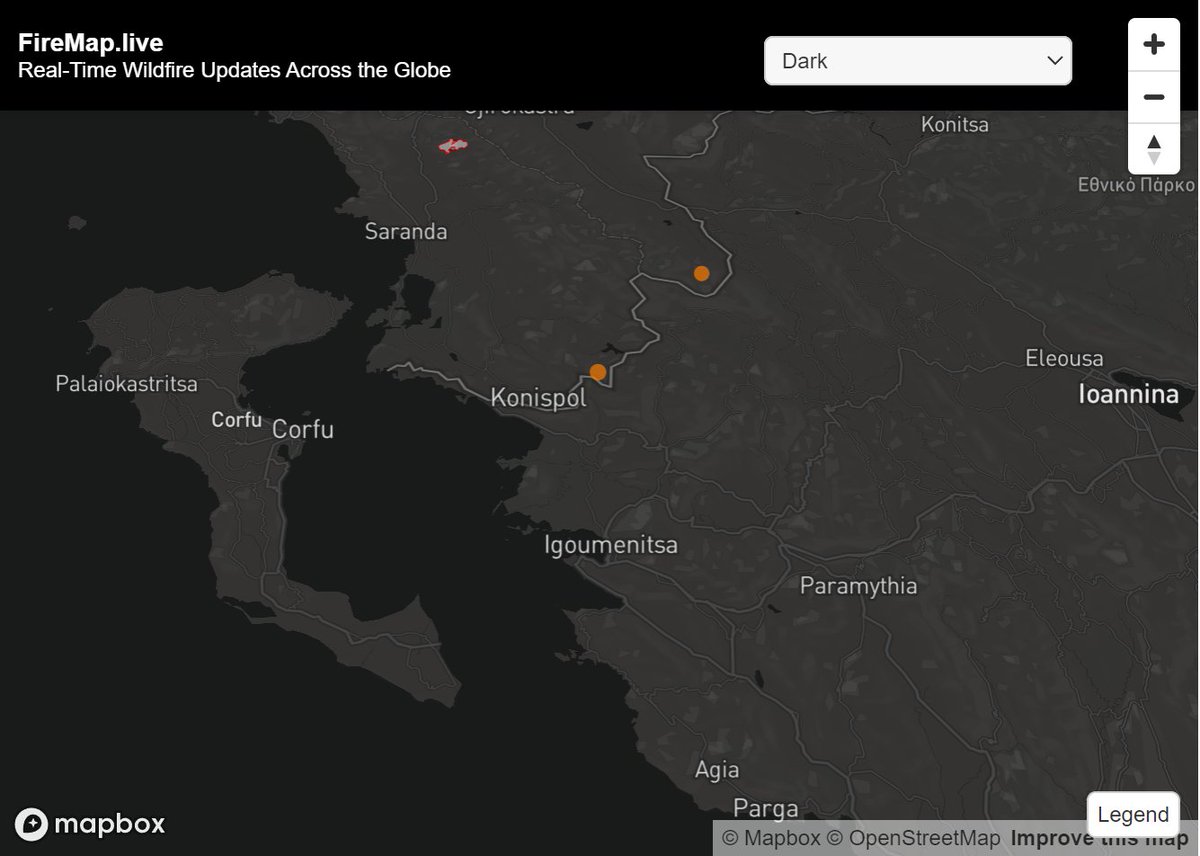
We are seeing a few of early fire detections on the border of Northern Greece & North Macedonia. Wildfires don't respect political boundaries.We saw with a Mexico/US fire yesterday. #firemap.live provides a global fire map from authoritative sources around the world with
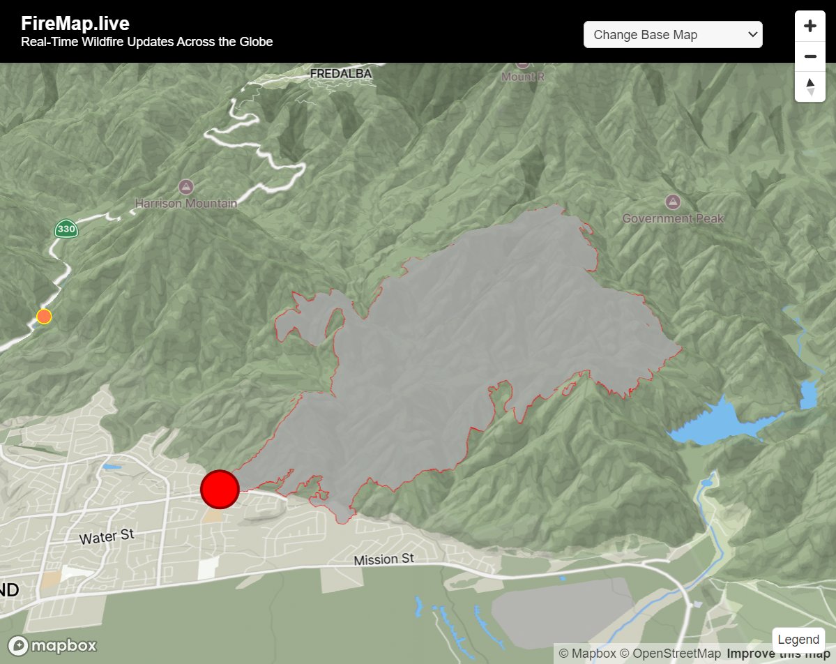
🔥LINE Fire, San Bernardino, California - Updated boundaries can be found on #FireMap #LineFire #SanBernardino @bdibar

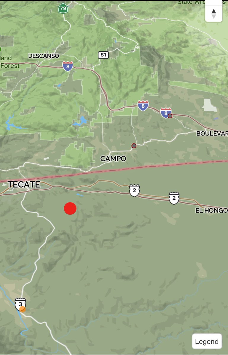
Early detection system hasn’t picked it up yet, but it appears that it’s very close to the Mexico fire that earlier this week. #FireMap
Something went wrong.
Something went wrong.
United States Trends
- 1. #LOVEISBLINDreunion N/A
- 2. Omar López N/A
- 3. #Survivor50 N/A
- 4. #AEWDynamite N/A
- 5. Salvador Pérez N/A
- 6. Jordan Clarkson N/A
- 7. Eugenio N/A
- 8. Massie N/A
- 9. Italy N/A
- 10. Jake Paul N/A
- 11. Vinnie N/A
- 12. Djokovic N/A
- 13. Devonta N/A
- 14. Priyanka N/A
- 15. Amber N/A
- 16. #WorldBaseballClassic N/A
- 17. Desmond Bane N/A
- 18. Japón N/A
- 19. Lee Majors N/A
- 20. #iubb N/A