#firstwarn3 ผลการค้นหา

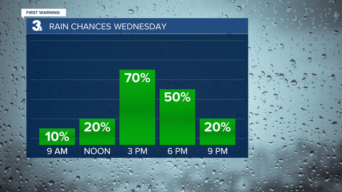
RAIN 📷 Showers & storms Wednesday afternoon to evening Strong to severe storms possible wtkr.com/weather #FirstWarn3

Here's a look at #sunset in Norfolk where it's 69°. Click here for more #FirstWarn3 cams ---> wtkr.com/weather/tower-… #twilight #Virginia


Flash Flood Warning until 9/27 7:15PM for City of Newport News, City of Hampton, City of Poquoson, York wtkr.com/weather #FirstWarn3

Severe Thunderstorm Warning until 9/01 5:00PM for City of Franklin, Southampton, Sussex wtkr.com/weather #FirstWarn3

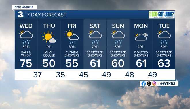
HERE'S WHAT to expect today and for the next seven days. More weather here --> wtkr.com/weather #FirstWarn3 #DependOnPatrick

Debby is still slowly moving closer to our part of the world in VA and NC. Our #FirstWarn3 Storm Team says we'll start to be impacted by Thursday. Biggest issue will be prolonged rainfall that could lead to a big flood threat. Stay with @WTKR3 and WTKR.com.


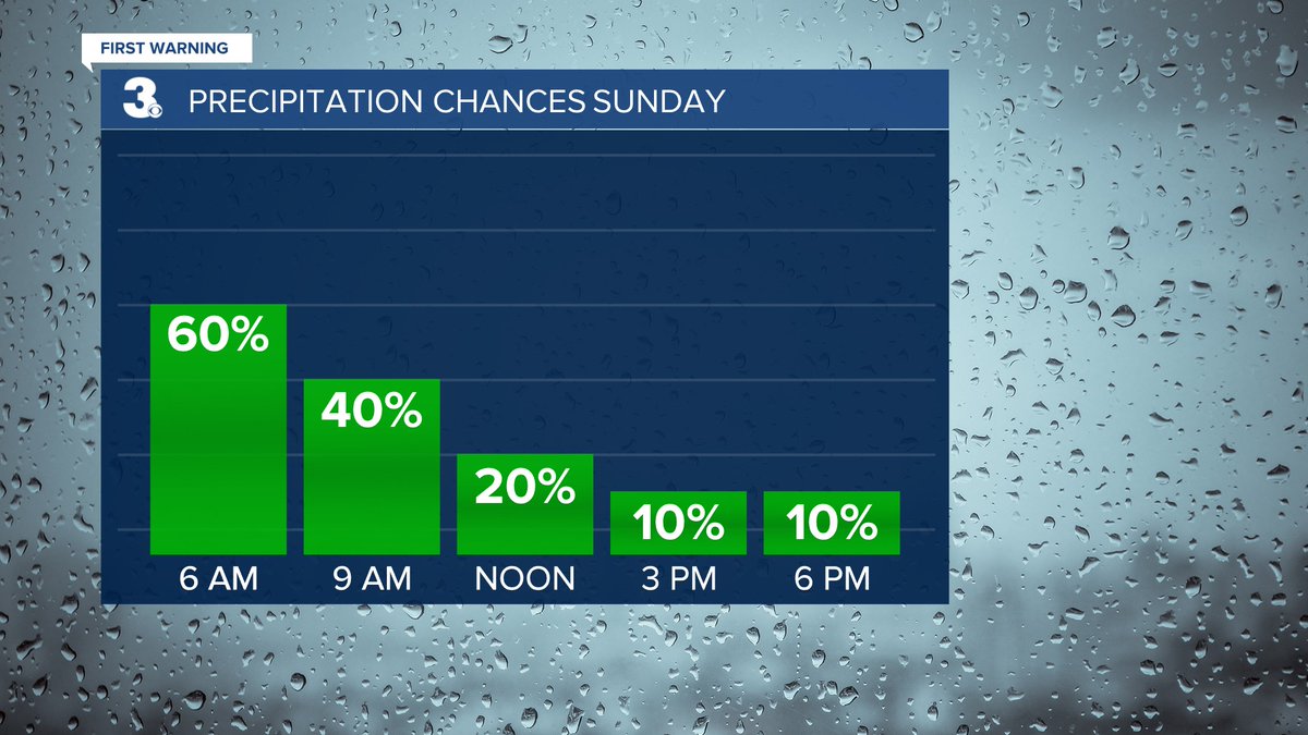
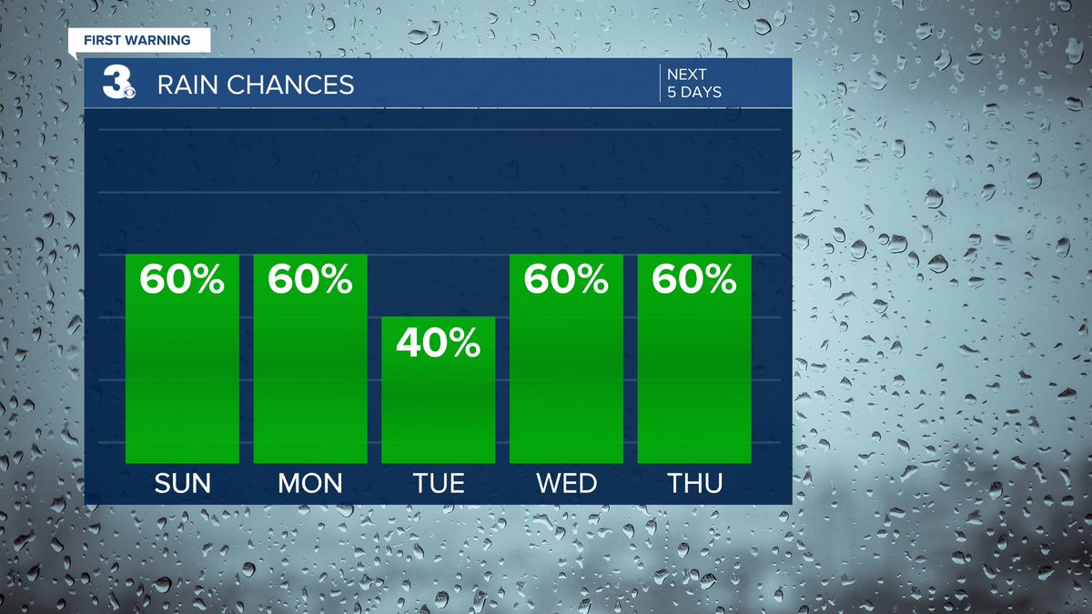
RAIN Showers this weekend Biggest chance Saturday night to Sunday morning wtkr.com/weather #FirstWarn3

NICE 📷 Highs in the low to mid 80s this week (below normal) Building humidity through midweek wtkr.com/weather #FirstWarn3


RADAR Showers this morning, mainly on the Peninsula, Middle Peninsula, and Eastern Shore Tracking NE wtkr.com/weather #FirstWarn3

SNOW ❄️ Scattered snow showers this morning, becoming more widespread this afternoon Heaviest snow tonight Snow moving out Sunday morning Higher snow accumulation south/east Lower snow accumulation north/west wtkr.com/weather #FirstWarn3

RAIN 📷 A dry first half of the week Showers likely Thursday night to Friday morning with a cold front wtkr.com/weather #FirstWarn3

Flash Flood Warning until 9/27 2:00PM for Southampton, Sussex, Greensville wtkr.com/weather #FirstWarn3
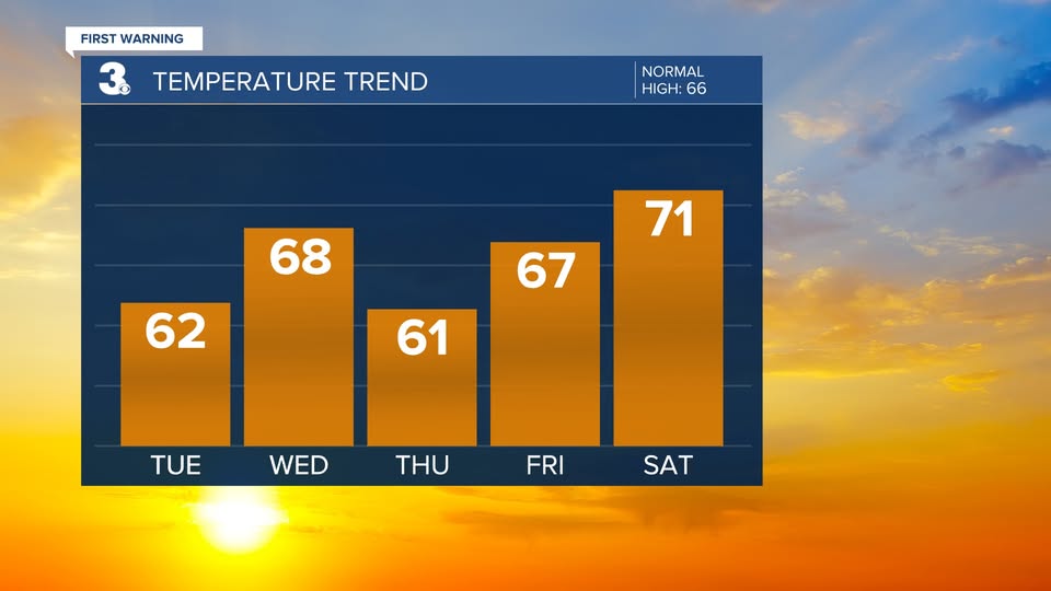
WARMER 🌡 Several days in the 70s to end the week 15 to 20degrees above normal wtkr.com/weather #FirstWarn3

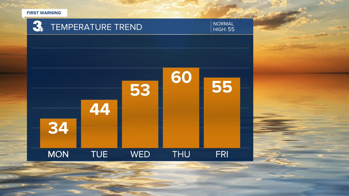
NICE 📷 Some small temperature variety through midweek A step warmer this weekend wtkr.com/weather #FirstWarn3
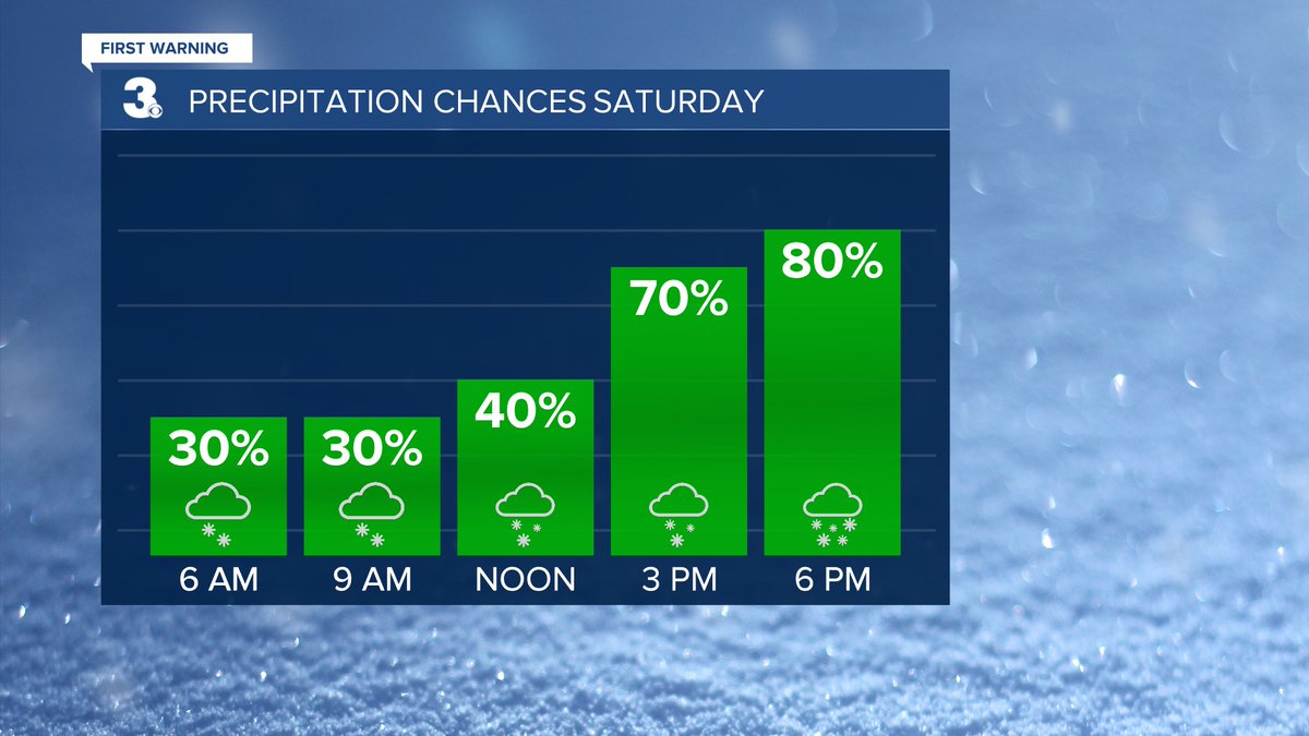
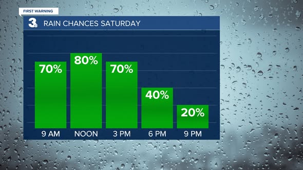
RAIN 📷 Split showers Saturday Widespread to the SE, scattered to the NW More rain for NE NC, not as much for SE VA wtkr.com/weather #FirstWarn3
RAIN 📷 Showers & storms Wednesday afternoon to evening Strong to severe storms possible wtkr.com/weather #FirstWarn3
RAIN Showers this weekend Biggest chance Saturday night to Sunday morning wtkr.com/weather #FirstWarn3
WARMER 🌡 Several days in the 70s to end the week 15 to 20degrees above normal wtkr.com/weather #FirstWarn3
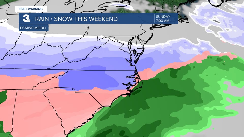
WEEKEND SAT: Scattered showers (mainly in NC) SUN: Widespread rain, Windy, Cooler wtkr.com/weather #FirstWarn3

RAIN 📷 On & off showers today More scattered Fri & Sat Soggy again on Sunday wtkr.com/weather #FirstWarn3

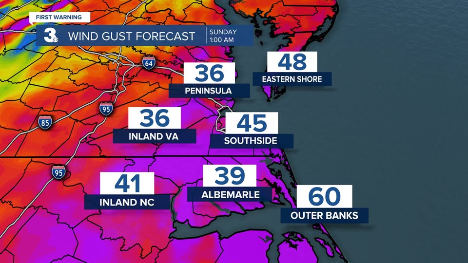
WINDY ⚠️ Winds will ramp up through the day Saturday Strongest wind Sunday morning Gusts to 40+ for many locations Gusts to 50+ along the coast wtkr.com/weather #FirstWarn3
SNOW ❄️ Scattered snow showers this morning, becoming more widespread this afternoon Heaviest snow tonight Snow moving out Sunday morning Higher snow accumulation south/east Lower snow accumulation north/west wtkr.com/weather #FirstWarn3
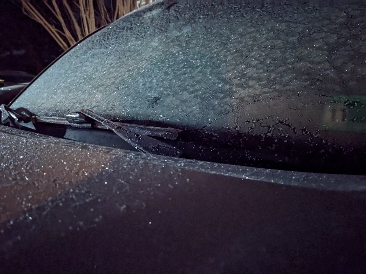
Snow started around 10 pm Saturday in Chesapeake. Some accumulation (0.5" to 0.75") before sunrise. #FirstWarn3
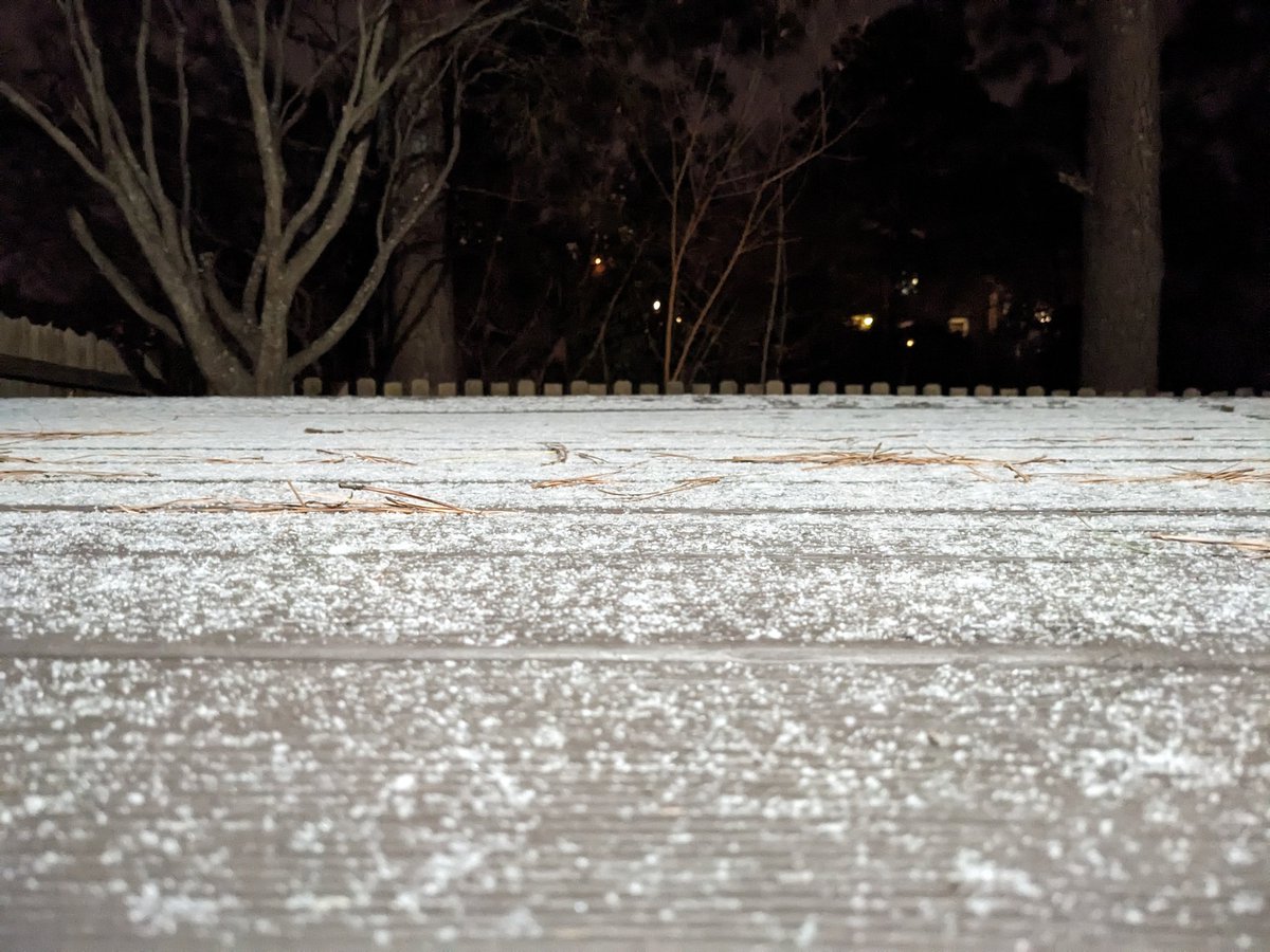
Some minor snow accumulation in Chesapeake (currently raining) @NWSWakefieldVA 0.5" in Hickory 0.7" in Great Bridge #FirstWarn3
WINTER STORM WATCH ❄️ Saturday to Monday We will see a mix of precipitation... Snow to mix to rain to mix Snow and ice accumulation likely wtkr.com/weather #FirstWarn3

FROST🥶 Give yourself some time to defrost this morning! (This was my view) wtkr.com/weather #FirstWarn3
SNOW Legitimate snow chance for this weekend (Jan 24 & 25) Significant accumulation possible Too early for specifics Expect the forecast to be updated and fine tuned wtkr.com/weather #FirstWarn3
RAIN 📷 A dry first half of the week Showers likely Thursday night to Friday morning with a cold front wtkr.com/weather #FirstWarn3
COLD 🥶 Temperatures in the teens and 20s Wind chill in the teens and single digits Only warming to the mid 30s this afternoon wtkr.com/weather #FirstWarn3

RADAR On the line... Snow to the NW, rain to the SE What are you seeing at your house? (I had all rain on my drive in from Chesapeake to Norfolk) wtkr.com/weather #FirstWarn3

Hitting the road early this morning? 🚗 The weather is looking pretty good across the Mid-Atlantic 👍 wtkr.com/weather #FirstWarn3

Here's a look at #sunset in Norfolk where it's 69°. Click here for more #FirstWarn3 cams ---> wtkr.com/weather/tower-… #twilight #Virginia
RAIN 📷 Split showers Saturday Widespread to the SE, scattered to the NW More rain for NE NC, not as much for SE VA wtkr.com/weather #FirstWarn3
HERE'S WHAT to expect today and for the next seven days. More weather here --> wtkr.com/weather #FirstWarn3 #DependOnPatrick
Severe Thunderstorm Warning until 7/27 5:00PM for Essex, Middlesex, King and Queen, Richmond, Lancaster, Northumberland, Westmoreland wtkr.com/weather #FirstWarn3

SNOW ❄️ Scattered snow showers this morning, becoming more widespread this afternoon Heaviest snow tonight Snow moving out Sunday morning Higher snow accumulation south/east Lower snow accumulation north/west wtkr.com/weather #FirstWarn3
RAIN 📷 Showers & storms Wednesday afternoon to evening Strong to severe storms possible wtkr.com/weather #FirstWarn3
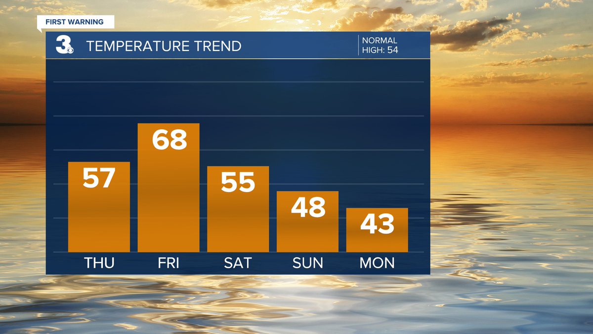
FALLING 📷 Warm again today A 20-degree drop for Thanksgiving Even cooler to end the week wtkr.com/weather #FirstWarn3

NICE 📷 Some small temperature variety through midweek A step warmer this weekend wtkr.com/weather #FirstWarn3
SOGGY 📷 Several chances for showers & storms ahead Rain from Chantal today and tomorrow A stationary front lingers for the rest of the week wtkr.com/weather #FirstWarn3
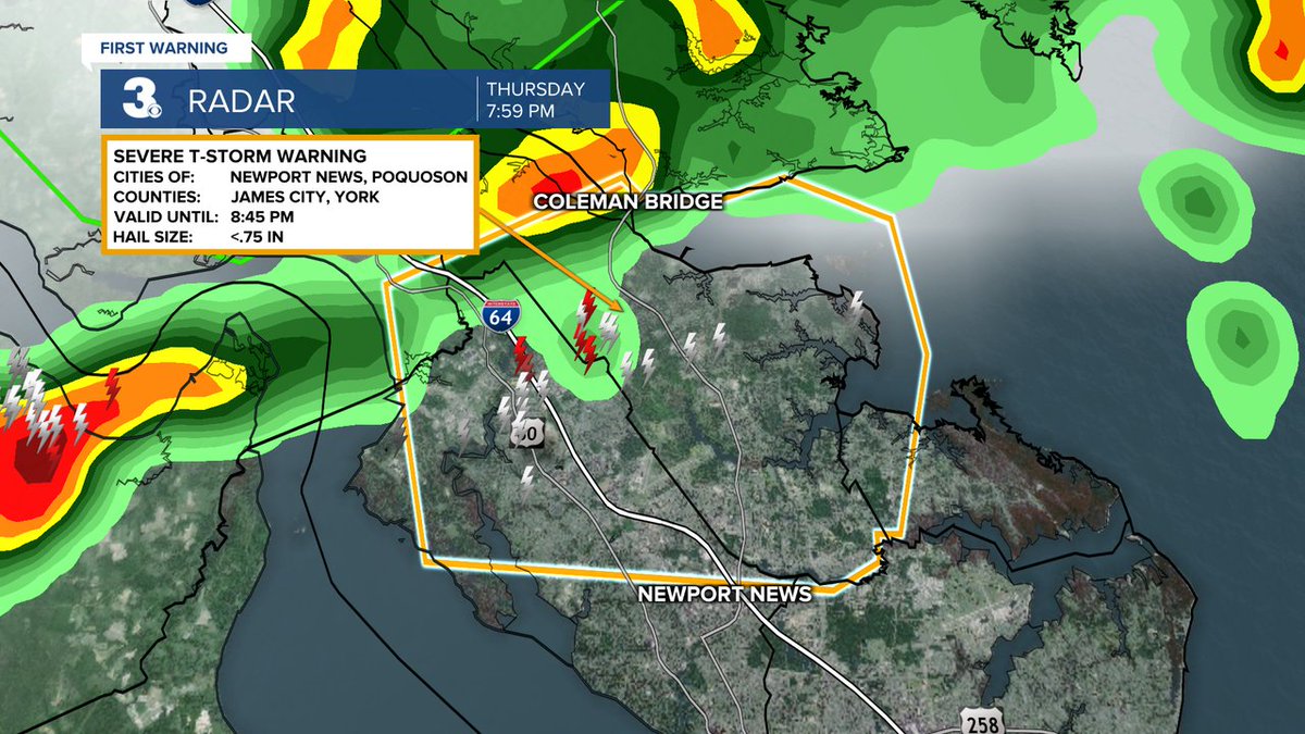
Severe Thunderstorm Warning until 7/31 8:45PM for City of Newport News, City of Poquoson, James City, York wtkr.com/weather #FirstWarn3
Severe Thunderstorm Warning until 7/27 5:45PM for Middlesex, Lancaster, Gloucester, King and Queen, Mathews, Northumberland wtkr.com/weather #FirstWarn3

WEEKEND SAT: Scattered showers (mainly in NC) SUN: Widespread rain, Windy, Cooler wtkr.com/weather #FirstWarn3
RAIN Showers this weekend Biggest chance Saturday night to Sunday morning wtkr.com/weather #FirstWarn3
Severe Thunderstorm Warning until 8/04 6:45PM for City of Suffolk, City of Franklin, Isle of Wight, Southampton wtkr.com/weather #FirstWarn3

WINDY ⚠️ Winds will ramp up through the day Saturday Strongest wind Sunday morning Gusts to 40+ for many locations Gusts to 50+ along the coast wtkr.com/weather #FirstWarn3
Severe Thunderstorm Warning until 9/01 5:00PM for City of Franklin, Southampton, Sussex wtkr.com/weather #FirstWarn3
WARMER 📷 Much warmer this weekend with highs in the 70s 60s to start next week wtkr.com/weather #FirstWarn3

Severe Thunderstorm Warning until 8/18 5:45PM for Prince George, Sussex, Surry, Dinwiddie wtkr.com/weather #FirstWarn3

Something went wrong.
Something went wrong.
United States Trends
- 1. Good Sunday N/A
- 2. #DMDLAND3DAY2 N/A
- 3. Benavidez N/A
- 4. Canelo N/A
- 5. Blessed Sunday N/A
- 6. Embiid N/A
- 7. Bivol N/A
- 8. T'Challa N/A
- 9. Zurdo N/A
- 10. El Paso N/A
- 11. #LoveYouTeacherSeriesEP8 N/A
- 12. Shuri N/A
- 13. #Toonami N/A
- 14. Maxey N/A
- 15. #EVOJapan2026 N/A
- 16. Black Panther N/A
- 17. #KUNxMetGala N/A
- 18. Knicks in 5 N/A
- 19. Emerson Hancock N/A
- 20. Secretariat N/A