#firstwarn3 zoekresultaten

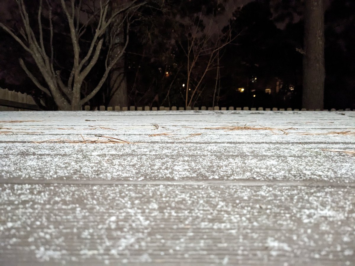
Snow started around 10 pm Saturday in Chesapeake. Some accumulation (0.5" to 0.75") before sunrise. #FirstWarn3
RADAR On the line... Snow to the NW, rain to the SE What are you seeing at your house? (I had all rain on my drive in from Chesapeake to Norfolk) wtkr.com/weather #FirstWarn3


Debby is still slowly moving closer to our part of the world in VA and NC. Our #FirstWarn3 Storm Team says we'll start to be impacted by Thursday. Biggest issue will be prolonged rainfall that could lead to a big flood threat. Stay with @WTKR3 and WTKR.com.

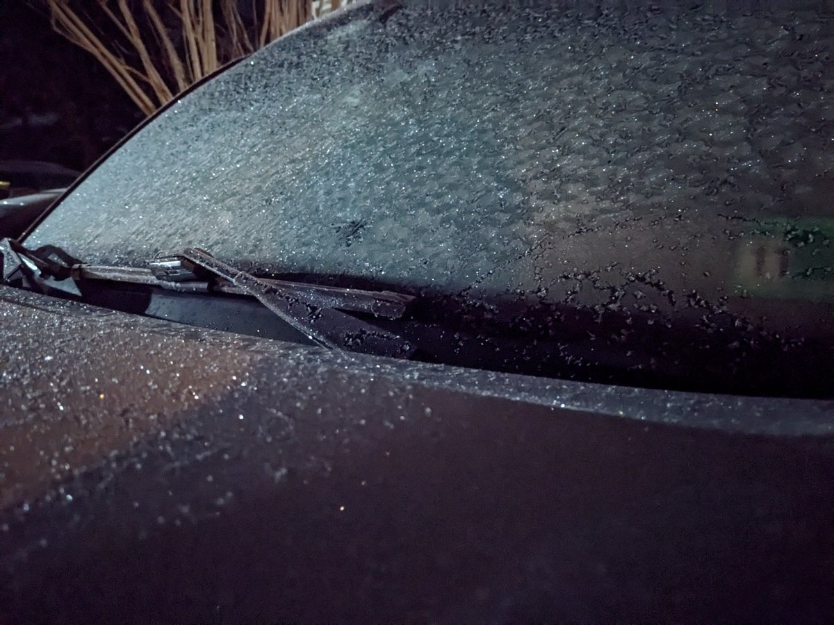
Some minor snow accumulation in Chesapeake (currently raining) @NWSWakefieldVA 0.5" in Hickory 0.7" in Great Bridge #FirstWarn3
COLD 🥶 Temperatures in the teens and 20s Wind chill in the teens and single digits Only warming to the mid 30s this afternoon wtkr.com/weather #FirstWarn3

TROPICS Hurricane Melissa made landfall early this morning in Cuba Forecast to track over the Bahamas today and near Bermuda late Thursday wtkr.com/weather #FirstWarn3


youtu.be/Zr68cw6coqs?si… #Stormhour #FirstWarn3 @PatrickRockey @SDagger02 @1carolinagirl #WUTV @TWCAlexWallace @Horror_Disciple @TommyDoyle47 @BlaineStewart I got this video Sunday.

youtube.com
YouTube
Summer Storm 9/1/2024
TROPICS Hurricane Melissa moves past Bermuda Tracking NE near the Canada coast tonight wtkr.com/weather #FirstWarn3

WINTER STORM WATCH ❄️ Saturday to Monday We will see a mix of precipitation... Snow to mix to rain to mix Snow and ice accumulation likely wtkr.com/weather #FirstWarn3

FROST🥶 Give yourself some time to defrost this morning! (This was my view) wtkr.com/weather #FirstWarn3

CURRENT Radar from the #FirstWarn3 Storm Team. Use our Interactive Radar here --> wtkr.com/weather/maps-a… #rain #showers #storm #thunderstorm #radar #wx #doppler #DependOnPatrick

7-DAY storm threat. Warnings here --> bit.do/Warning3 Track storms here--> wtkr.com/weather/maps-a… #FirstWarn3 #tornado #severe #thunderstorm #flood #watch #warning #weather #lightning #rain #hail #wind #wx


SNOW Legitimate snow chance for this weekend (Jan 24 & 25) Significant accumulation possible Too early for specifics Expect the forecast to be updated and fine tuned wtkr.com/weather #FirstWarn3
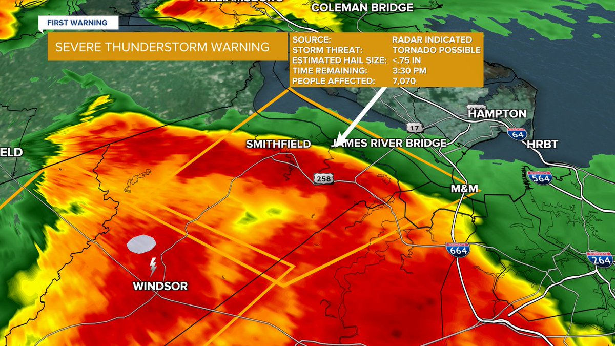
Severe Thunderstorm Warning until 9/01 6:45PM for City of Norfolk, City of Newport News, City of Hampton, City of Chesapeake, City of Portsmouth, City of Suffolk, City of Virginia Beach wtkr.com/weather #FirstWarn3

Flash Flood Warning until 10/01 12:15PM for Sussex, Surry, Southampton, Isle of Wight wtkr.com/weather #FirstWarn3
DON'T go to bed without the #FirstWarn3 Forecast. Join us in minutes for @wtkr3 at 11 or online: wtkr.com/live #wtkr #news #tvnews #latenews #news3 #forecast #weather
Severe Thunderstorm Warning until 9/01 5:30PM for Isle of Wight, Sussex, Southampton, Surry wtkr.com/weather #FirstWarn3

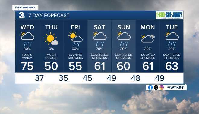
HERE'S WHAT to expect today and for the next seven days. More weather here --> wtkr.com/weather #FirstWarn3 #DependOnPatrick
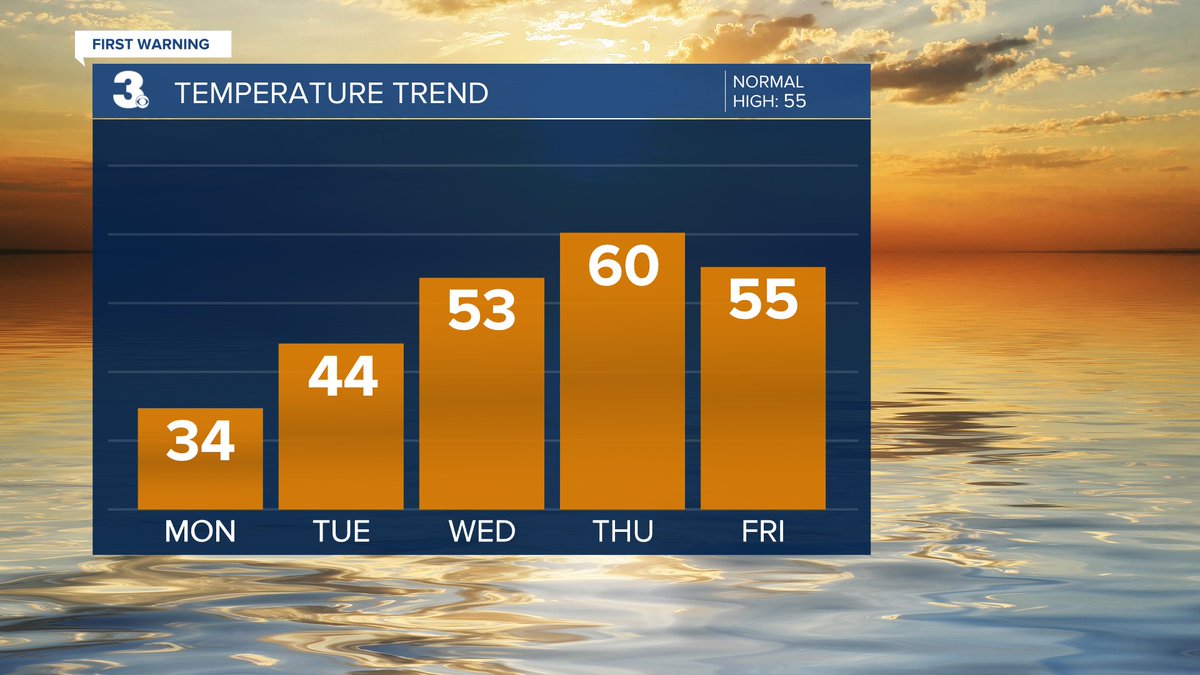
WARMER 🌡 Several days in the 70s to end the week 15 to 20degrees above normal wtkr.com/weather #FirstWarn3

WEEKEND SAT: Scattered showers (mainly in NC) SUN: Widespread rain, Windy, Cooler wtkr.com/weather #FirstWarn3

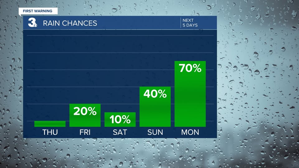
RAIN 📷 On & off showers today More scattered Fri & Sat Soggy again on Sunday wtkr.com/weather #FirstWarn3


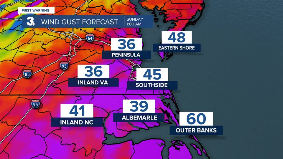
WINDY ⚠️ Winds will ramp up through the day Saturday Strongest wind Sunday morning Gusts to 40+ for many locations Gusts to 50+ along the coast wtkr.com/weather #FirstWarn3
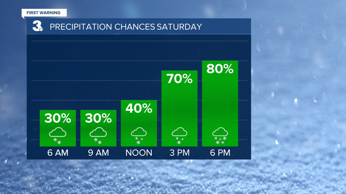
SNOW ❄️ Scattered snow showers this morning, becoming more widespread this afternoon Heaviest snow tonight Snow moving out Sunday morning Higher snow accumulation south/east Lower snow accumulation north/west wtkr.com/weather #FirstWarn3

Snow started around 10 pm Saturday in Chesapeake. Some accumulation (0.5" to 0.75") before sunrise. #FirstWarn3
Some minor snow accumulation in Chesapeake (currently raining) @NWSWakefieldVA 0.5" in Hickory 0.7" in Great Bridge #FirstWarn3
WINTER STORM WATCH ❄️ Saturday to Monday We will see a mix of precipitation... Snow to mix to rain to mix Snow and ice accumulation likely wtkr.com/weather #FirstWarn3
FROST🥶 Give yourself some time to defrost this morning! (This was my view) wtkr.com/weather #FirstWarn3
SNOW Legitimate snow chance for this weekend (Jan 24 & 25) Significant accumulation possible Too early for specifics Expect the forecast to be updated and fine tuned wtkr.com/weather #FirstWarn3
RAIN 📷 A dry first half of the week Showers likely Thursday night to Friday morning with a cold front wtkr.com/weather #FirstWarn3

COLD 🥶 Temperatures in the teens and 20s Wind chill in the teens and single digits Only warming to the mid 30s this afternoon wtkr.com/weather #FirstWarn3
RADAR On the line... Snow to the NW, rain to the SE What are you seeing at your house? (I had all rain on my drive in from Chesapeake to Norfolk) wtkr.com/weather #FirstWarn3
Hitting the road early this morning? 🚗 The weather is looking pretty good across the Mid-Atlantic 👍 wtkr.com/weather #FirstWarn3

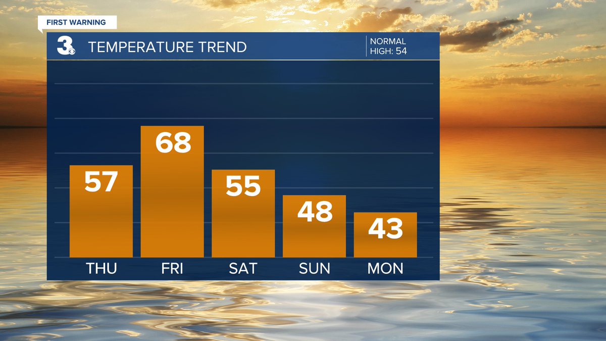
FALLING 📷 Warm again today A 20-degree drop for Thanksgiving Even cooler to end the week wtkr.com/weather #FirstWarn3

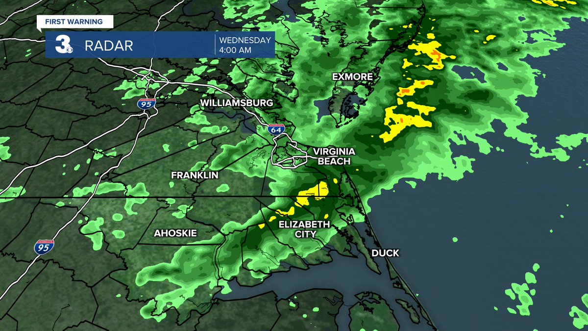
RADAR Showers this morning, mainly on the Peninsula, Middle Peninsula, and Eastern Shore Tracking NE wtkr.com/weather #FirstWarn3

RADAR Showers to start this Wednesday morning Back to sunshine this afternoon wtkr.com/weather #FirstWarn3

Severe Thunderstorm Warning until 7/25 9:45PM for Northampton, Accomack wtkr.com/weather #FirstWarn3

RAIN 📷 Slim chances to end the workweek Scattered showers Sunday Showers & storms Monday wtkr.com/weather #FirstWarn3
CURRENT Radar from the #FirstWarn3 Storm Team. Use our Interactive Radar here --> wtkr.com/weather/maps-a… #rain #showers #storm #thunderstorm #radar #wx #doppler #DependOnPatrick
RAIN 📷 A dry first half of the week Showers likely Thursday night to Friday morning with a cold front wtkr.com/weather #FirstWarn3
WINTER STORM WATCH ❄️ Saturday to Monday We will see a mix of precipitation... Snow to mix to rain to mix Snow and ice accumulation likely wtkr.com/weather #FirstWarn3
Severe Thunderstorm Warning until 9/01 5:30PM for Isle of Wight, Sussex, Southampton, Surry wtkr.com/weather #FirstWarn3
Severe Thunderstorm Warning until 7/19 3:00PM for City of Franklin, Isle of Wight, Southampton, City of Suffolk wtkr.com/weather #FirstWarn3

HERE'S WHAT to expect today and for the next seven days. More weather here --> wtkr.com/weather #FirstWarn3 #DependOnPatrick
TROPICS Hurricane Melissa moves past Bermuda Tracking NE near the Canada coast tonight wtkr.com/weather #FirstWarn3
Severe Thunderstorm Warning until 7/19 3:30PM for Isle of Wight, City of Suffolk wtkr.com/weather #FirstWarn3
Severe Thunderstorm Warning until 8/19 6:00PM for City of Williamsburg, Gloucester, Middlesex, Lancaster, King William, King and Queen, Charles City, Essex, James City, Mathews, New Kent, York wtkr.com/weather #FirstWarn3

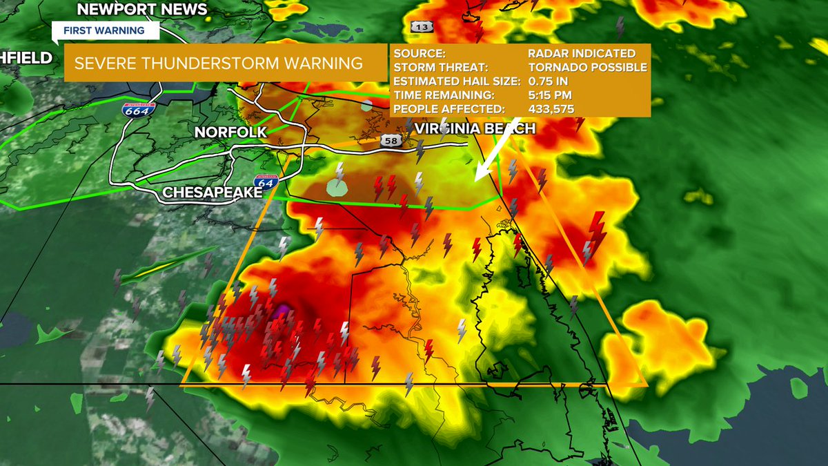
Severe Thunderstorm Warning until 7/19 5:15PM for City of Virginia Beach, City of Chesapeake wtkr.com/weather #FirstWarn3
WARMER 🌡 Several days in the 70s to end the week 15 to 20degrees above normal wtkr.com/weather #FirstWarn3
EASTER 📷 An early look at the forecast for Easter Sunday Mix of clouds, slim rain chances, breezy wtkr.com/weather #FirstWarn3


Severe Thunderstorm Warning until 7/27 4:45PM for Washington, Hyde, Tyrrell, Dare wtkr.com/weather #FirstWarn3

SOGGY 📷 Several chances for showers & storms ahead Rain from Chantal today and tomorrow A stationary front lingers for the rest of the week wtkr.com/weather #FirstWarn3
Severe Thunderstorm Warning until 7/27 5:45PM for Middlesex, Lancaster, Gloucester, King and Queen, Mathews, Northumberland wtkr.com/weather #FirstWarn3

TROPICS Tropical Storm Melissa form over the Caribbean Sea Expected to turn north toward Haiti and Jamaica wtkr.com/weather #FirstWarn3

7-DAY storm threat. Warnings here --> bit.do/Warning3 Track storms here--> wtkr.com/weather/maps-a… #FirstWarn3 #tornado #severe #thunderstorm #flood #watch #warning #weather #lightning #rain #hail #wind #wx
SNOW Legitimate snow chance for this weekend (Jan 24 & 25) Significant accumulation possible Too early for specifics Expect the forecast to be updated and fine tuned wtkr.com/weather #FirstWarn3
Something went wrong.
Something went wrong.
United States Trends
- 1. #Verzuz N/A
- 2. Houston N/A
- 3. Arkansas N/A
- 4. Tyrese N/A
- 5. Arizona N/A
- 6. Iowa N/A
- 7. Purdue N/A
- 8. Chase DeLauter N/A
- 9. Elite 8 N/A
- 10. #ILLINI N/A
- 11. #thepitt N/A
- 12. #GuardsBall N/A
- 13. Bully N/A
- 14. #ENHYPEN_IS_7 N/A
- 15. Nebraska N/A
- 16. Trey Songz N/A
- 17. Elite Eight N/A
- 18. Team Red Bill N/A
- 19. Kelvin Sampson N/A
- 20. Wagler N/A