#floodsimulation search results

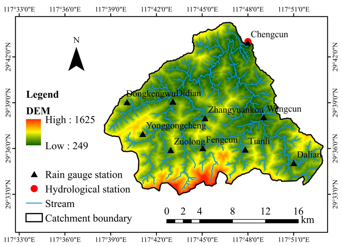
🔥 Read our Highly Cited Paper 📚 Application of a Fractional Instantaneous Unit Hydrograph in the TOPMODEL: A Case Study in Chengcun Basin, China 🔗 mdpi.com/2076-3417/13/4… 👨🔬 by Mr. Xin Xiang et al. #floodsimulation @SCUCN

Step 3: Evacuate! Community members get their household together and gather their most important belongings in a Go-Bag. Then they head to their village's assigned Evacuation Center. #floodsimulation
Step 4: Rescue! Sometimes a flood hits some families faster than others. That means the #RescueTeam needs to get into action. #floodsimulation
Step 5: More than one rescue happens at the same time. That means "all hands on deck!" Here, the #RescueTeam is practicing getting someone down from a tree. #floodsimulation
Step 2: The Communication Officer receives the alert and announces it, 📢 really loud, to the rest of the community. #floodsimulation

Heliware recently had an interaction with one of the nation's leading Solar power based company. We utilized the meeting to present our "Flood simulation and 3D analytics features of heliware for Group mounted solar sites". #heliware #floodsimulation #3d #analytics #solar #power

✈️ By quantifying the impact of model configuration decisions, we're taking a step towards a deeper understanding of uncertainty in hydrological modeling. 7/7 #Hydrology #FloodSimulation #Research #SUMMA #WaterResources 🧵
Communities in the #Philippines practice what to do when a flood hits. They simulate the whole scenario to prepare. Step 1: The district sends out an alert that floods are expected. #floodsimulation

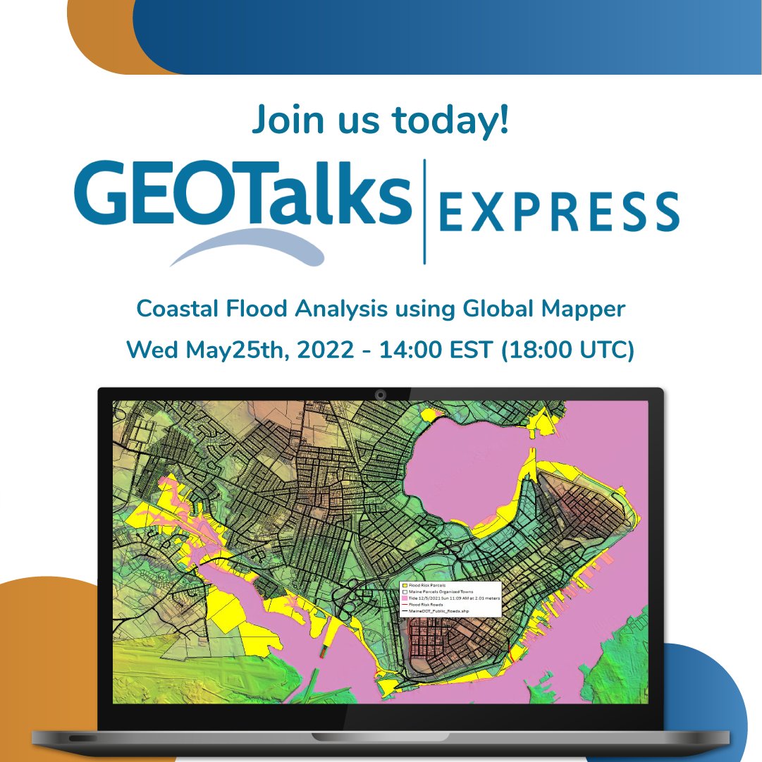
With the Earth’s climate changing, we are experiencing more intense and frequent extreme weather events. Join us at our next #webinar to learn how to use the #floodsimulation and #watershed tools in #GlobalMapper. Register at: ow.ly/Lmqz50J36XF


आइओएमको पहलमा नेपाली सुरक्षा निकायहरुले केही दिन अघि बाँके जिल्लाको डुडुवा गाउँपालिकामा मनसुन #पूर्वतयारी अन्तर्गत #उद्धार #अभ्यास गरेकोछ। लुम्बिनी प्रदेश सरकारको अगुवाइ, यूएसएडको आर्थिक सहयोग। #MonsoonPreparedness #Nepal @USAIDNepal @USAIDSavesLives @IOMAsiaPacific @UN_Nepal

New fast #floodmodel has potentially life-saving benefits The Low-Fidelity, Spatial Analysis and Gaussian Process Learning (LSG) model could produce predictions that are as accurate as advanced simulation models at speeds that are 1,000 times faster. #FloodSimulation


: Step 2: The Communication Officer receives the alert and announces it, 📢 really loud, to the rest of the community. #floodsimulation

Good examples of innovations using #data such as #3d technology for #floodsimulation and #waterinsight @Min_IenM tinylink.net/zpI

HPHF, facilitated a 3-Day Advanced GIS & Flood Simulation Workshop empowering 21 participants to apply cutting-edge tools for flood modelling & disaster preparedness. #DisasterPreparedness #GIS #FloodSimulation #Resilience #Collaboration


: Step 3: Evacuate! Community members get their household together and gather their most important belongings in a Go-Bag. Then they head to their village's assigned Evacuation Center. #floodsimulation

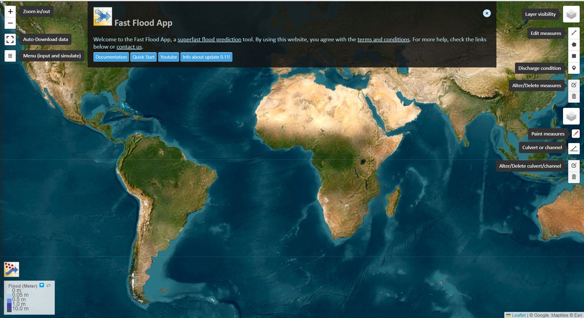
🌊 Experience Fastflood.org: Simulate Floods in Seconds! 🌊 Kudos to the brilliant team at ITC, University of Twente, for transforming complex academic research into an accessible online platform. #Fastflood #FloodSimulation #Innovation #ITCUTwente

With the Earth’s climate changing, we are experiencing more intense and frequent extreme weather events. Join us at our next #webinar to learn how to use the #floodsimulation and #watershed tools in #GlobalMapper. Register at: ow.ly/Taoh50J36Zk

: Once people get to their assigned Evacuation Center during the #floodsimulation in the #Philippines, they must register. This is a simple way to ensure everyone in the community is safe.
: Step 5: More than one rescue happens at the same time. That means "all hands on deck!" Here, the #RescueTeam is practicing getting someone down from a tree. #floodsimulation
Our Student Intern, Luis Enriquez, from Cristo Rey High School Sacramento, created this great presentation using a flood simulation model on how RD1000 combats flooding. Check it out here: ow.ly/lBTU50F2hqr #Natomas #FloodSimulation #FloodControl

HPHF, facilitated a 3-Day Advanced GIS & Flood Simulation Workshop empowering 21 participants to apply cutting-edge tools for flood modelling & disaster preparedness. #DisasterPreparedness #GIS #FloodSimulation #Resilience #Collaboration

Let's shape the future of risk management together! 🔗 viitorcloud.com/contact-us #UrbanResilience #DigitalTwin #FloodSimulation #ViitorCloud #DigitalExperience #Dubai

🔥 Read our Highly Cited Paper 📚 Application of a Fractional Instantaneous Unit Hydrograph in the TOPMODEL: A Case Study in Chengcun Basin, China 🔗 mdpi.com/2076-3417/13/4… 👨🔬 by Mr. Xin Xiang et al. #floodsimulation @SCUCN
✈️ By quantifying the impact of model configuration decisions, we're taking a step towards a deeper understanding of uncertainty in hydrological modeling. 7/7 #Hydrology #FloodSimulation #Research #SUMMA #WaterResources 🧵
New fast #floodmodel has potentially life-saving benefits The Low-Fidelity, Spatial Analysis and Gaussian Process Learning (LSG) model could produce predictions that are as accurate as advanced simulation models at speeds that are 1,000 times faster. #FloodSimulation
Decision-makers, especially water agencies, take note - this innovative tool can be a game-changer. Explore Fastflood.org today and dive into the world of flood simulation! 🌐⚙ #Fastflood #FloodSimulation #Innovation #ITCUTwente
Fastflood.org is an open-source, super-fast flood model right in your browser, and it's making waves in record time! 🚀💡 #Fastflood #FloodSimulation #Innovation #ITCUTwente

🌊 Experience Fastflood.org: Simulate Floods in Seconds! 🌊 Kudos to the brilliant team at ITC, University of Twente, for transforming complex academic research into an accessible online platform. #Fastflood #FloodSimulation #Innovation #ITCUTwente
आइओएमको पहलमा नेपाली सुरक्षा निकायहरुले केही दिन अघि बाँके जिल्लाको डुडुवा गाउँपालिकामा मनसुन #पूर्वतयारी अन्तर्गत #उद्धार #अभ्यास गरेकोछ। लुम्बिनी प्रदेश सरकारको अगुवाइ, यूएसएडको आर्थिक सहयोग। #MonsoonPreparedness #Nepal @USAIDNepal @USAIDSavesLives @IOMAsiaPacific @UN_Nepal
With the Earth’s climate changing, we are experiencing more intense and frequent extreme weather events. Join us at our next #webinar to learn how to use the #floodsimulation and #watershed tools in #GlobalMapper. Register at: ow.ly/Taoh50J36Zk
With the Earth’s climate changing, we are experiencing more intense and frequent extreme weather events. Join us at our next #webinar to learn how to use the #floodsimulation and #watershed tools in #GlobalMapper. Register at: ow.ly/Lmqz50J36XF
Join us at our next #webinar to learn how #floodsimulation and #watershed tools can be used to model the flow of water over terrain to determine #floodrisk areas and damages. Register at ow.ly/oXpB50ITnyP

Join us at our next #webinar to learn how #floodsimulation and #watershed tools can be used to model the flow of water over terrain to determine #floodrisk areas and damages. Register at ow.ly/C1IS50ITnxR

🔥 Read our Highly Cited Paper 📚 Application of a Fractional Instantaneous Unit Hydrograph in the TOPMODEL: A Case Study in Chengcun Basin, China 🔗 mdpi.com/2076-3417/13/4… 👨🔬 by Mr. Xin Xiang et al. #floodsimulation @SCUCN
Heliware recently had an interaction with one of the nation's leading Solar power based company. We utilized the meeting to present our "Flood simulation and 3D analytics features of heliware for Group mounted solar sites". #heliware #floodsimulation #3d #analytics #solar #power
With the Earth’s climate changing, we are experiencing more intense and frequent extreme weather events. Join us at our next #webinar to learn how to use the #floodsimulation and #watershed tools in #GlobalMapper. Register at: ow.ly/Lmqz50J36XF
HPHF, facilitated a 3-Day Advanced GIS & Flood Simulation Workshop empowering 21 participants to apply cutting-edge tools for flood modelling & disaster preparedness. #DisasterPreparedness #GIS #FloodSimulation #Resilience #Collaboration
New fast #floodmodel has potentially life-saving benefits The Low-Fidelity, Spatial Analysis and Gaussian Process Learning (LSG) model could produce predictions that are as accurate as advanced simulation models at speeds that are 1,000 times faster. #FloodSimulation
Join us at our next #webinar to learn how #floodsimulation and #watershed tools can be used to model the flow of water over terrain to determine #floodrisk areas and damages. Register at ow.ly/oXpB50ITnyP
With the Earth’s climate changing, we are experiencing more intense and frequent extreme weather events. Join us at our next #webinar to learn how to use the #floodsimulation and #watershed tools in #GlobalMapper. Register at: ow.ly/Taoh50J36Zk
🌊 Experience Fastflood.org: Simulate Floods in Seconds! 🌊 Kudos to the brilliant team at ITC, University of Twente, for transforming complex academic research into an accessible online platform. #Fastflood #FloodSimulation #Innovation #ITCUTwente
Join us at our next #webinar to learn how #floodsimulation and #watershed tools can be used to model the flow of water over terrain to determine #floodrisk areas and damages. Register at ow.ly/C1IS50ITnxR

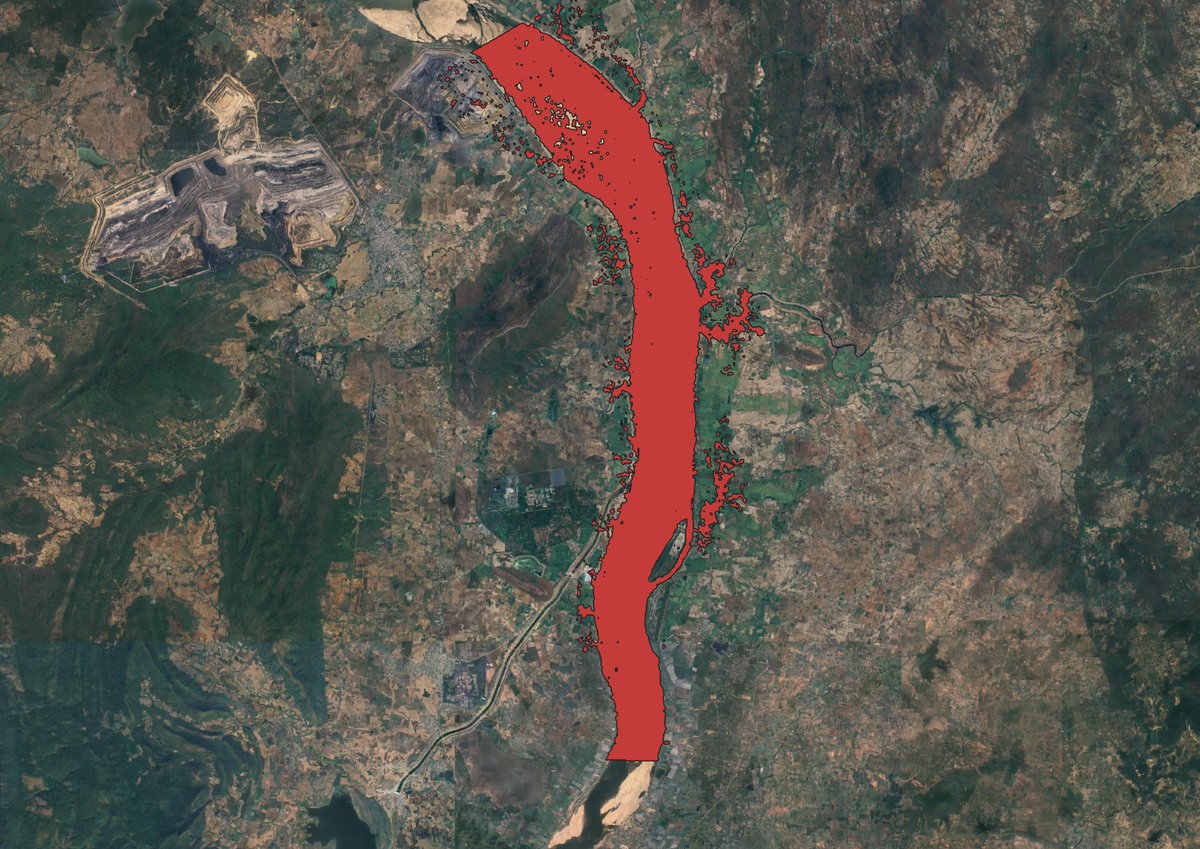
FloodSim: #FloodSimulation and #Visualization Framework Using Position-Based Fluids by I. Alihan Hadimlioglu, Scott A. King and Michael J. Starek 👉mdpi.com/2220-9964/9/3/… #SurfaceRunoff #Lagrangian

Our Student Intern, Luis Enriquez, from Cristo Rey High School Sacramento, created this great presentation using a flood simulation model on how RD1000 combats flooding. Check it out here: ow.ly/lBTU50F2hqr #Natomas #FloodSimulation #FloodControl
Something went wrong.
Something went wrong.
United States Trends
- 1. Star Fox N/A
- 2. #Survivor50 N/A
- 3. #beyondthevilla N/A
- 4. Draymond N/A
- 5. Paul Skenes N/A
- 6. #AEWDynamite N/A
- 7. #PorVida N/A
- 8. Barkley N/A
- 9. Lincoln Logs N/A
- 10. Hantavirus N/A
- 11. Nintendo N/A
- 12. Cirie N/A
- 13. Ozzy N/A
- 14. #GoSpursGo N/A
- 15. Doris Burke N/A
- 16. Kent State N/A
- 17. Spencer Pratt N/A
- 18. Dostal N/A
- 19. Sean Manaea N/A
- 20. FREENBECKY THE AIR PRESS TOUR N/A