#geospatialengineers search results

PARTNERSHIP! 🛰️ #AWiSC2025 is excited to partner with GESA (Geospatial Engineering Students Association, UoN)! Connecting future #GeospatialEngineers with the space industry. Crucial for #WorkforceDevelopment! Register FREE NOW! womeninspace.ke/awisc-2025/ #GESA #UoN #GIS


IT unit Intelligence Unit Geospatial Engineers are much needed right now and training will be offered if interested.
#GeospatialEngineers support Civil-Military Operations (#CMO) Information Management by generating layered #geospatial information and #civil layers for the Common Operating Picture (#COP).

What do #GeospatialEngineers do? 🌎 Geospatial engineering plays a crucial role in understanding and managing the spatial aspects of our world, enabling better planning, resource allocation, and problem-solving. Learn more about #GeospatialEngineering: ow.ly/3ZQj50UUiau

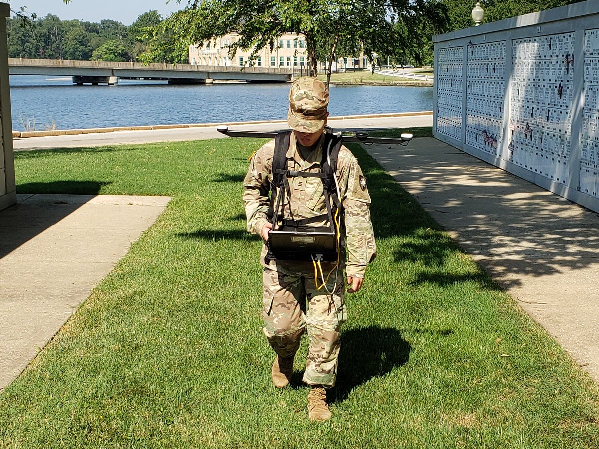
The @ArmyGeospatial Product Director, Combat Terrain Information Systems, equips Active Duty #GeospatialEngineers with the latest #survey technology. #modernization
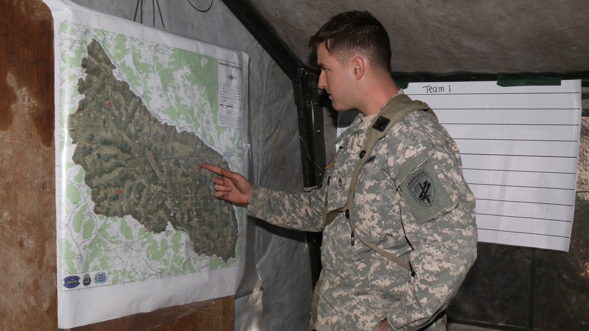
#Army #GeospatialEngineers viewed @ArmyGeospatial's Urban Tactical Planner during #GISDay2021 at #USAES, @fortleonardwood. #technology #essayons

.@USArmy #GeospatialEngineers #survey using the latest technology, including #ENFIRE, Global Positioning System - Survey (#GPS-S), and Automated Integrated Survey Instruments (#AISI). #survey #modernization


These @MtnDewKickstart steady getting me through day after day of training America's next generation of Army Engineer Soldiers. #usarmyengineerschool #geospatialengineers #armystrong

@dehub_dekut only Done by space specialist #Gegis #GeospatialEngineers Dkut
The Winter 2021 issue of Army Engineer Magazine highlights @USArmy #GeospatialEngineers and their accomplishments. Learn more at armyengineer.com/Jan%202021%20M…


Discovering the world, one survey at a time! Proud to be a part of shaping the future with cutting-edge technology and innovative solutions in surveying and geospatial engineering. #YoungSurveyors #GeospatialEngineers #BuildingTheFuture

3D laser scanning allows #GeospatialEngineers to survey their site even when certain areas are inaccessible! 🏥 Find out how BAM Ireland use #3DLaserScanning to construct the New Children's Hospital (NCH) in Dublin 👇 geospatialuk.org/post/using-3d-…
geospatialuk.org
Using 3D Laser Scanning to Construct a New Children’s Hospital
Referred to in planning documents simply as the New Children’s Hospital (NCH), the new facility is due to combine the services currently provided at Dublin’s three tertiary children’s hospitals:...
IT unit Intelligence Unit Geospatial Engineers are much needed right now and training will be offered if interested.
PARTNERSHIP! 🛰️ #AWiSC2025 is excited to partner with GESA (Geospatial Engineering Students Association, UoN)! Connecting future #GeospatialEngineers with the space industry. Crucial for #WorkforceDevelopment! Register FREE NOW! womeninspace.ke/awisc-2025/ #GESA #UoN #GIS
What do #GeospatialEngineers do? 🌎 Geospatial engineering plays a crucial role in understanding and managing the spatial aspects of our world, enabling better planning, resource allocation, and problem-solving. Learn more about #GeospatialEngineering: ow.ly/3ZQj50UUiau
Discovering the world, one survey at a time! Proud to be a part of shaping the future with cutting-edge technology and innovative solutions in surveying and geospatial engineering. #YoungSurveyors #GeospatialEngineers #BuildingTheFuture
3D laser scanning allows #GeospatialEngineers to survey their site even when certain areas are inaccessible! 🏥 Find out how BAM Ireland use #3DLaserScanning to construct the New Children's Hospital (NCH) in Dublin 👇 geospatialuk.org/post/using-3d-…
geospatialuk.org
Using 3D Laser Scanning to Construct a New Children’s Hospital
Referred to in planning documents simply as the New Children’s Hospital (NCH), the new facility is due to combine the services currently provided at Dublin’s three tertiary children’s hospitals:...
#Army #GeospatialEngineers viewed @ArmyGeospatial's Urban Tactical Planner during #GISDay2021 at #USAES, @fortleonardwood. #technology #essayons
#GeospatialEngineers support Civil-Military Operations (#CMO) Information Management by generating layered #geospatial information and #civil layers for the Common Operating Picture (#COP).
.@USArmy #GeospatialEngineers #survey using the latest technology, including #ENFIRE, Global Positioning System - Survey (#GPS-S), and Automated Integrated Survey Instruments (#AISI). #survey #modernization
The @ArmyGeospatial Product Director, Combat Terrain Information Systems, equips Active Duty #GeospatialEngineers with the latest #survey technology. #modernization
The Winter 2021 issue of Army Engineer Magazine highlights @USArmy #GeospatialEngineers and their accomplishments. Learn more at armyengineer.com/Jan%202021%20M…
These @MtnDewKickstart steady getting me through day after day of training America's next generation of Army Engineer Soldiers. #usarmyengineerschool #geospatialengineers #armystrong
@dehub_dekut only Done by space specialist #Gegis #GeospatialEngineers Dkut
PARTNERSHIP! 🛰️ #AWiSC2025 is excited to partner with GESA (Geospatial Engineering Students Association, UoN)! Connecting future #GeospatialEngineers with the space industry. Crucial for #WorkforceDevelopment! Register FREE NOW! womeninspace.ke/awisc-2025/ #GESA #UoN #GIS
The Winter 2021 issue of Army Engineer Magazine highlights @USArmy #GeospatialEngineers and their accomplishments. Learn more at armyengineer.com/Jan%202021%20M…
#Army #GeospatialEngineers viewed @ArmyGeospatial's Urban Tactical Planner during #GISDay2021 at #USAES, @fortleonardwood. #technology #essayons
The @ArmyGeospatial Product Director, Combat Terrain Information Systems, equips Active Duty #GeospatialEngineers with the latest #survey technology. #modernization
#GeospatialEngineers support Civil-Military Operations (#CMO) Information Management by generating layered #geospatial information and #civil layers for the Common Operating Picture (#COP).
.@USArmy #GeospatialEngineers #survey using the latest technology, including #ENFIRE, Global Positioning System - Survey (#GPS-S), and Automated Integrated Survey Instruments (#AISI). #survey #modernization
What do #GeospatialEngineers do? 🌎 Geospatial engineering plays a crucial role in understanding and managing the spatial aspects of our world, enabling better planning, resource allocation, and problem-solving. Learn more about #GeospatialEngineering: ow.ly/3ZQj50UUiau
Something went wrong.
Something went wrong.
United States Trends
- 1. Good Monday 32.3K posts
- 2. #MondayMotivation 8,513 posts
- 3. TOP CALL 3,917 posts
- 4. AI Alert 1,630 posts
- 5. Check Analyze N/A
- 6. Token Signal 2,131 posts
- 7. Market Focus 2,705 posts
- 8. Victory Monday 1,571 posts
- 9. #centralwOrldXmasXFreenBecky 630K posts
- 10. SAROCHA REBECCA DISNEY AT CTW 647K posts
- 11. #LingOrmDiorAmbassador 322K posts
- 12. NAMJOON 63.5K posts
- 13. DOGE 189K posts
- 14. #BaddiesUSA 67.6K posts
- 15. Chip Kelly 9,667 posts
- 16. Happy Thanksgiving 10.3K posts
- 17. Monad 123K posts
- 18. Stacey 23.6K posts
- 19. Stefanski 9,870 posts
- 20. Scotty 10.7K posts