#inclusivemapping search results
With hands-on experience on how to use the app, teams of volunteers are moving around Ssebowa village, mapping and updating features digitally. Anyone can use this app to update map data in their community, happy #mappy weekend. Every contribution counts. #InclusiveMapping 2/2

Your involvement has not only contributed to the reliable & people-powered #map of the community but has also brought us closer together to share skills and creative ideas. When we come together, we can make a significant impact. #InclusiveMapping 3/3

and visibility to remote or less-developed areas. We appreciate everyone who has taken on this task to enrich and update the #map, thank you. #OpenMapping #InclusiveMapping 2/2

the most current view of our community, a great asset in planning, #response and navigation. "Detailed local knowledge gives the best understanding of our neighborhoods, streets and services", says Ronald Tumusiime. #InclusiveMapping #DataScience 2/2


At #Mapcreator, we're making maps accessible for everyone. Our blog shows how to design maps for the 300M colorblind people globally. Learn key principles, color schemes, and readability tips. mapcreator.io/news/see-the-w… #InclusiveMapping #ColorblindFriendly

A few words from @AwaniaMorish, who was the lead in the successful #MapHerWorld compaign. We appreciate @openmapping_esa for sponsoring this event, supporting the community in updating maps, for better planning and service delivery systems. #InclusiveMapping #EveryDoor
Explore @dkwiens latest blog entry diving into the realm of map-to-speech technology, bridging geospatial expertise with inclusiveness. Join us on this journey towards a more accessible and inclusive mapping future. #AccessibilityTech #InclusiveMapping bit.ly/4bjekN8


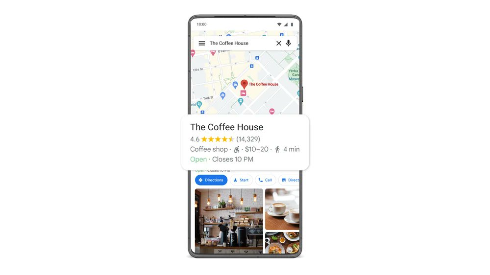
Discover wheelchair-accessible places on #GoogleMaps! ♿️ Accessible Places feature helps you find step-free entrances, ensuring a smooth experience for wheelchair users, stroller-pushers, and travelers. Know before you go! 🌍🚶♀️🧳 #AccessiblePlaces #InclusiveMapping #AccessForAll
Through #OpenStreetMap, we update & contribute to detailed community maps. #Maps are valuable tools in promoting inclusive spaces, education, urban planning, healthier & more sustainable services. Visit the link below for details wiki.openstreetmap.org/wiki/Main_Page #InclusiveMapping
2/2 The NLNT project is changing that by promoting an inclusive perspective on hiking trails and Indigenous heritage. 🗺️✨ #InclusiveMapping #IndigenousHistoryMonth
.#Mapping is the first step to lighting up the path to development, it gives us a chance to add available futures to the map and advocate for those that are not available in our different communities. #openmapping #InclusiveMapping #sustainability 2/2
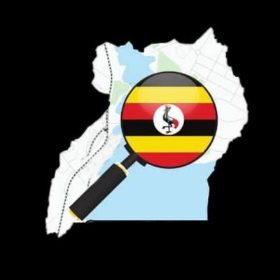
be effectively set up to better serve these populations. Imagine how much we can do with detailed geographical information! Join us in our journey to empower communities by mapping every corner of our beautiful country. #MappingUganda #InclusiveMapping #OpenMapping
reduce travel times and increase access to markets, schools, hospitals and other services. It's time to put every community on the map, join us to make this possible. #InclusiveMapping #Sustainability 2/2
which covers theoretical aspects such as drone programming, aerodynamics, and safety regulations, and practical application by teaching them to operate and troubleshoot drones for various applications like surveying, mapping and data gathering. #OpenMapping #InclusiveMapping 2/2
By being involved, #OpenMapping gives the community a better understanding of their environment's resource/facility navigation and distribution. Click here for more details on how OSM Uganda is leading this initiative in #schools osmuganda.medium.com/transforming-e… #InclusiveMapping 2/2
osmuganda.medium.com
Transforming Education with Digital and Open Mapping skills
In Uganda, despite having a population of over 45 million people, a very small percentage actively contribute to OpenStreetMap. This low…
The #DiMDiCi project is about the co-design of a digital #InclusiveMapping tool with a group of citizens with diverse abilities from the city of Herne (Germany) To find out more about their research, read their pilot presentation 👉coeso.hypotheses.org/4880

in-demand careers. It's more than just maps; it's about community engagement, critical thinking and global collaboration. For details, read here; adailabz.com #EducationForAll #digitalliteracy #InclusiveMapping 2/2
Field mapping is essential in updating & adding details to features on the #map to improve area navigation, which in turn boosts up businesses, eases transport and makes it easier to locate service providers. #OpenMapping #InclusiveMapping #DataScience 2/2
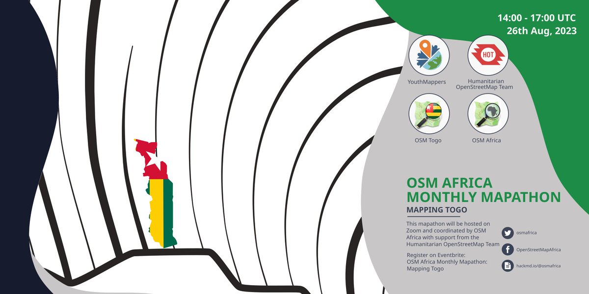
Registration for the @osmafrica August marathon is open, register and get your tickets now @OSMTogo here we come Remember, every contribution counts #MapTogo #InclusiveMapping
📢Registration is open for our August Mapathon to #MapTogo 🇹🇬 with @OSMTogo - Get your free ticket now eventbrite.co.uk/e/osm-africa-a…
ensuring they are seen, heard & catered to, every place and it's people matter. Link to the place names mapping data: osmuganda.maps.arcgis.com/apps/dashboard… Comment your thoughts, let's keep the conversation going. #OpenMapping #InclusiveMapping #OpenStreetMap 2/2
At #Mapcreator, we're making maps accessible for everyone. Our blog shows how to design maps for the 300M colorblind people globally. Learn key principles, color schemes, and readability tips. mapcreator.io/news/see-the-w… #InclusiveMapping #ColorblindFriendly
Explore @dkwiens latest blog entry diving into the realm of map-to-speech technology, bridging geospatial expertise with inclusiveness. Join us on this journey towards a more accessible and inclusive mapping future. #AccessibilityTech #InclusiveMapping bit.ly/4bjekN8
in-demand careers. It's more than just maps; it's about community engagement, critical thinking and global collaboration. For details, read here; adailabz.com #EducationForAll #digitalliteracy #InclusiveMapping 2/2
Field mapping is essential in updating & adding details to features on the #map to improve area navigation, which in turn boosts up businesses, eases transport and makes it easier to locate service providers. #OpenMapping #InclusiveMapping #DataScience 2/2
ensuring they are seen, heard & catered to, every place and it's people matter. Link to the place names mapping data: osmuganda.maps.arcgis.com/apps/dashboard… Comment your thoughts, let's keep the conversation going. #OpenMapping #InclusiveMapping #OpenStreetMap 2/2
Registration for the @osmafrica August marathon is open, register and get your tickets now @OSMTogo here we come Remember, every contribution counts #MapTogo #InclusiveMapping
📢Registration is open for our August Mapathon to #MapTogo 🇹🇬 with @OSMTogo - Get your free ticket now eventbrite.co.uk/e/osm-africa-a…
Light on the #InclusiveMapping! The researchers designed a map of Herne taking into account the different approaches to the city in relation to their capacity 🌞dimdici.hypotheses.org @UTwente @Stadt_Herne @hsgesundheit

Through #OpenStreetMap, we update & contribute to detailed community maps. #Maps are valuable tools in promoting inclusive spaces, education, urban planning, healthier & more sustainable services. Visit the link below for details wiki.openstreetmap.org/wiki/Main_Page #InclusiveMapping
By being involved, #OpenMapping gives the community a better understanding of their environment's resource/facility navigation and distribution. Click here for more details on how OSM Uganda is leading this initiative in #schools osmuganda.medium.com/transforming-e… #InclusiveMapping 2/2
osmuganda.medium.com
Transforming Education with Digital and Open Mapping skills
In Uganda, despite having a population of over 45 million people, a very small percentage actively contribute to OpenStreetMap. This low…
and visibility to remote or less-developed areas. We appreciate everyone who has taken on this task to enrich and update the #map, thank you. #OpenMapping #InclusiveMapping 2/2
which covers theoretical aspects such as drone programming, aerodynamics, and safety regulations, and practical application by teaching them to operate and troubleshoot drones for various applications like surveying, mapping and data gathering. #OpenMapping #InclusiveMapping 2/2
Interested in #inclusivemapping ? Find out more about the DiMiDiCi research project and how they developped a collaborative mapping tool in @Stadt_Herne by visiting their blog 👉dimdici.hypotheses.org @hsgesundheit @UTwente

be effectively set up to better serve these populations. Imagine how much we can do with detailed geographical information! Join us in our journey to empower communities by mapping every corner of our beautiful country. #MappingUganda #InclusiveMapping #OpenMapping
reduce travel times and increase access to markets, schools, hospitals and other services. It's time to put every community on the map, join us to make this possible. #InclusiveMapping #Sustainability 2/2
.#Mapping is the first step to lighting up the path to development, it gives us a chance to add available futures to the map and advocate for those that are not available in our different communities. #openmapping #InclusiveMapping #sustainability 2/2
Your involvement has not only contributed to the reliable & people-powered #map of the community but has also brought us closer together to share skills and creative ideas. When we come together, we can make a significant impact. #InclusiveMapping 3/3
A few words from @AwaniaMorish, who was the lead in the successful #MapHerWorld compaign. We appreciate @openmapping_esa for sponsoring this event, supporting the community in updating maps, for better planning and service delivery systems. #InclusiveMapping #EveryDoor
With hands-on experience on how to use the app, teams of volunteers are moving around Ssebowa village, mapping and updating features digitally. Anyone can use this app to update map data in their community, happy #mappy weekend. Every contribution counts. #InclusiveMapping 2/2
the most current view of our community, a great asset in planning, #response and navigation. "Detailed local knowledge gives the best understanding of our neighborhoods, streets and services", says Ronald Tumusiime. #InclusiveMapping #DataScience 2/2
We believe in the power of collective knowledge, let's map our community together. If you haven't registered for the #MapHerWorld campaign, click on the link below forms.gle/cxve33s5x1Mmon… #InclusiveMapping #DataScience #EveryDoor 3/3
At #Mapcreator, we're making maps accessible for everyone. Our blog shows how to design maps for the 300M colorblind people globally. Learn key principles, color schemes, and readability tips. mapcreator.io/news/see-the-w… #InclusiveMapping #ColorblindFriendly
Explore @dkwiens latest blog entry diving into the realm of map-to-speech technology, bridging geospatial expertise with inclusiveness. Join us on this journey towards a more accessible and inclusive mapping future. #AccessibilityTech #InclusiveMapping bit.ly/4bjekN8
With hands-on experience on how to use the app, teams of volunteers are moving around Ssebowa village, mapping and updating features digitally. Anyone can use this app to update map data in their community, happy #mappy weekend. Every contribution counts. #InclusiveMapping 2/2
and visibility to remote or less-developed areas. We appreciate everyone who has taken on this task to enrich and update the #map, thank you. #OpenMapping #InclusiveMapping 2/2
Your involvement has not only contributed to the reliable & people-powered #map of the community but has also brought us closer together to share skills and creative ideas. When we come together, we can make a significant impact. #InclusiveMapping 3/3
Discover wheelchair-accessible places on #GoogleMaps! ♿️ Accessible Places feature helps you find step-free entrances, ensuring a smooth experience for wheelchair users, stroller-pushers, and travelers. Know before you go! 🌍🚶♀️🧳 #AccessiblePlaces #InclusiveMapping #AccessForAll
the #EveryDoor app is easy to understand and use. Your contribution, no matter how small, could be the detail that helps someone navigate their world more efficiently. We are looking forward to meeting you and seeing the POIs you will map. #InclusiveMapping #OpenStreetMap 3/3


the most current view of our community, a great asset in planning, #response and navigation. "Detailed local knowledge gives the best understanding of our neighborhoods, streets and services", says Ronald Tumusiime. #InclusiveMapping #DataScience 2/2
The #DiMDiCi project is about the co-design of a digital #InclusiveMapping tool with a group of citizens with diverse abilities from the city of Herne (Germany) To find out more about their research, read their pilot presentation 👉coeso.hypotheses.org/4880
Light on the #InclusiveMapping! The researchers designed a map of Herne taking into account the different approaches to the city in relation to their capacity 🌞dimdici.hypotheses.org @UTwente @Stadt_Herne @hsgesundheit
Interested in #inclusivemapping ? Find out more about the DiMiDiCi research project and how they developped a collaborative mapping tool in @Stadt_Herne by visiting their blog 👉dimdici.hypotheses.org @hsgesundheit @UTwente
Something went wrong.
Something went wrong.
United States Trends
- 1. Giants 63.8K posts
- 2. Bills 135K posts
- 3. Bears 56.8K posts
- 4. Caleb 45.9K posts
- 5. Dart 24.3K posts
- 6. Dolphins 30.7K posts
- 7. Daboll 9,849 posts
- 8. Josh Allen 14.3K posts
- 9. Russell Wilson 3,693 posts
- 10. Jags 6,142 posts
- 11. Texans 36.2K posts
- 12. Browns 35.5K posts
- 13. Ravens 35.6K posts
- 14. Patriots 101K posts
- 15. Henderson 15.9K posts
- 16. Trevor Lawrence 2,218 posts
- 17. Drake Maye 14.4K posts
- 18. Bryce 15K posts
- 19. Vikings 29K posts
- 20. JJ McCarthy 4,526 posts