#landviewer search results

All #GENSO #LAND owners could use #LANDViewer to check the location of your LANDs anytime. 🔭LAND viewer: bit.ly/3XnyJsa You may find #LAND on the secondary market if you have yet to buy it. 🚩 market.genso.game/marketplace/la… Let's build a wonderful #metaverse with


The Palace of #Versailles is one of the most iconic symbols of French history, architecture, and culture. With #EOSDA #LandViewer, you can explore the detailed layout of Versailles, and track changes over time using high-resolution #satellite imagery: bit.ly/42yncLN


Severe flooding in #Valencia after a year’s worth of rain fell in just 8 hours. Using EOSDA #LandViewer, we show the impact with #IndexStack & #ColorInfrared, revealing changes in vegetation & water spread. Our thoughts are with Valencia: bit.ly/4fqCPJ8
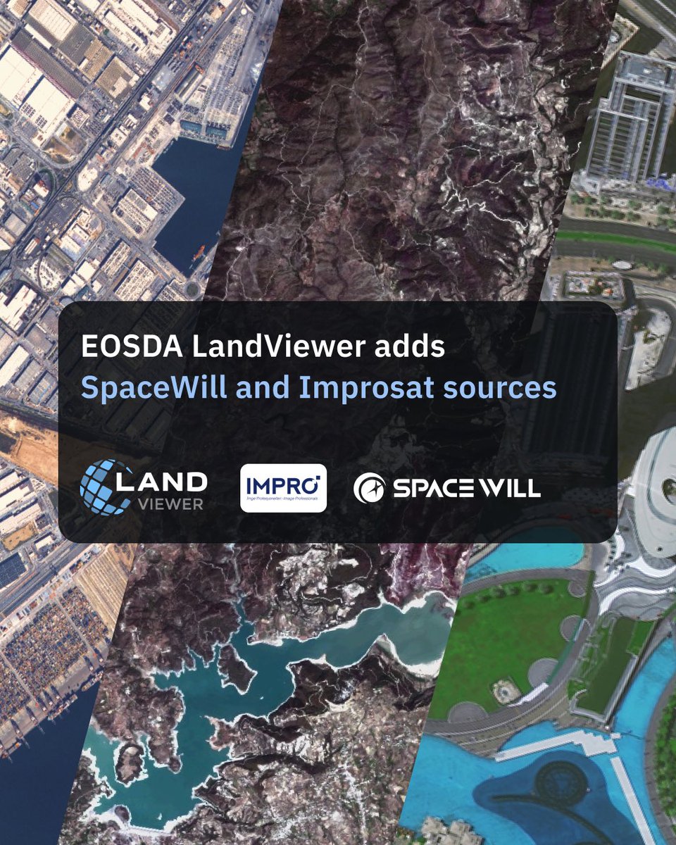
EOSDA #LandViewer is further expanding its satellite data sources with the addition of #SpaceWill (new #SuperView Neo-1 and Neo-3 satellites) and Improsat (#Göktürk-1 satellite) imagery. Learn more: bit.ly/3JE1b84
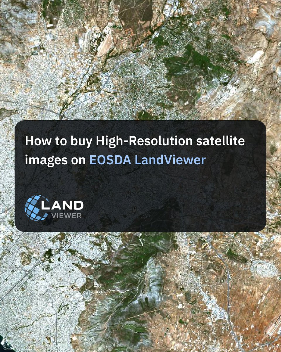
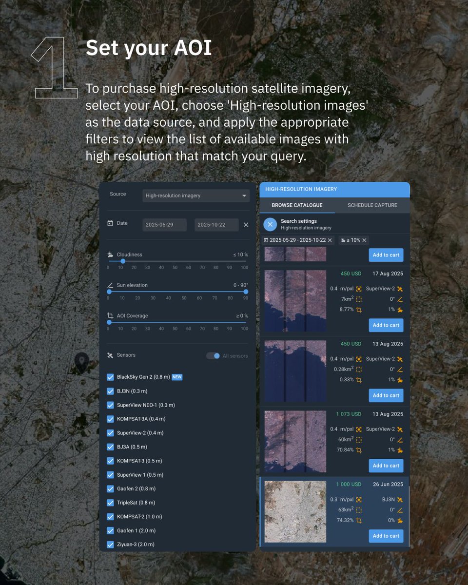
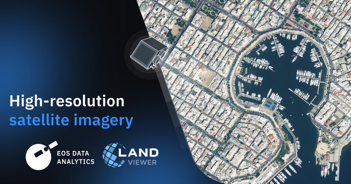
High-resolution satellite sensors provide enhanced spatial resolution for the most accurate, reliable, and timely data. With #EOSDA #LandViewer, you can easily purchase imagery from the world’s leading high-resolution satellite imagery providers: bit.ly/42yncLN
Black Friday pricing ends in 48 hours. 📅 Get full access to #EOSDA #LandViewer at the lowest rate of the year — offer valid until November 28. Don’t miss your chance to start working with satellite data today. Your secret link: bit.ly/3X0xkKd
Win-win with #EOSDA #LandViewer! 🎁 Buy a monthly EOSDA LandViewer subscription between November 17–28 and get a chance to win a free upgrade to the full year of the Pro Plan! 📲 Enter now: bit.ly/3X0xkKd Terms and conditions details: eos.com/blog/landviewe…

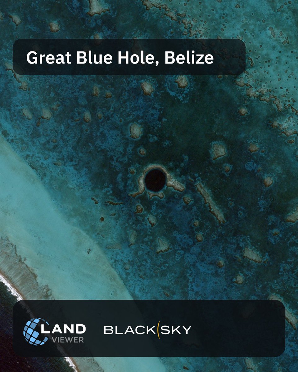
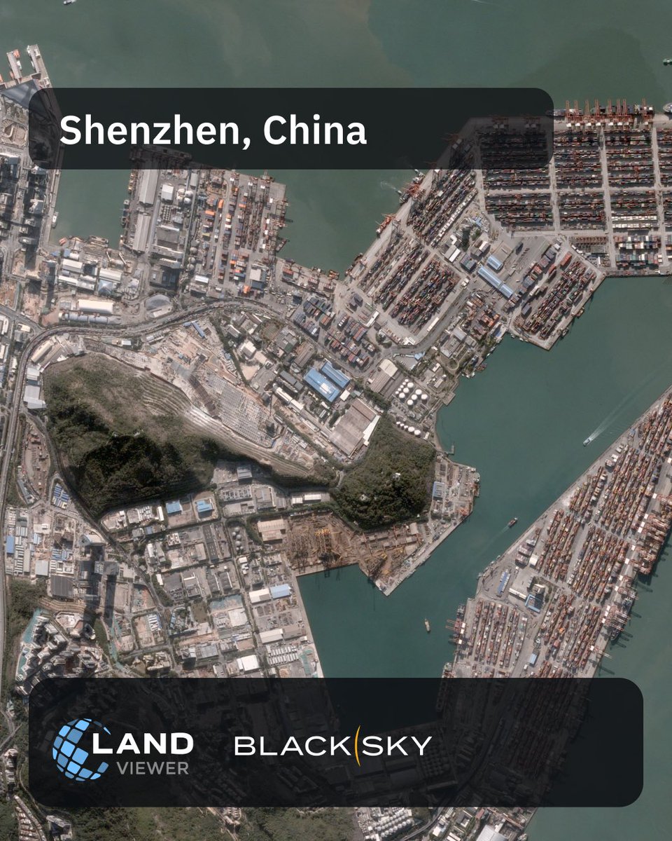
🛰️ @BlackSky_Inc imagery now available in #EOSDA #LandViewer! Access submeter data and up to 15 revisits/day for time series, change detection & high-activity zone monitoring.📍 Try it: bit.ly/EOSDALandViewer
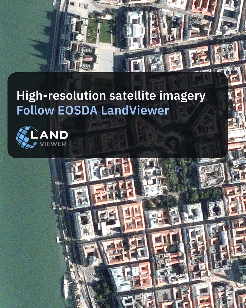
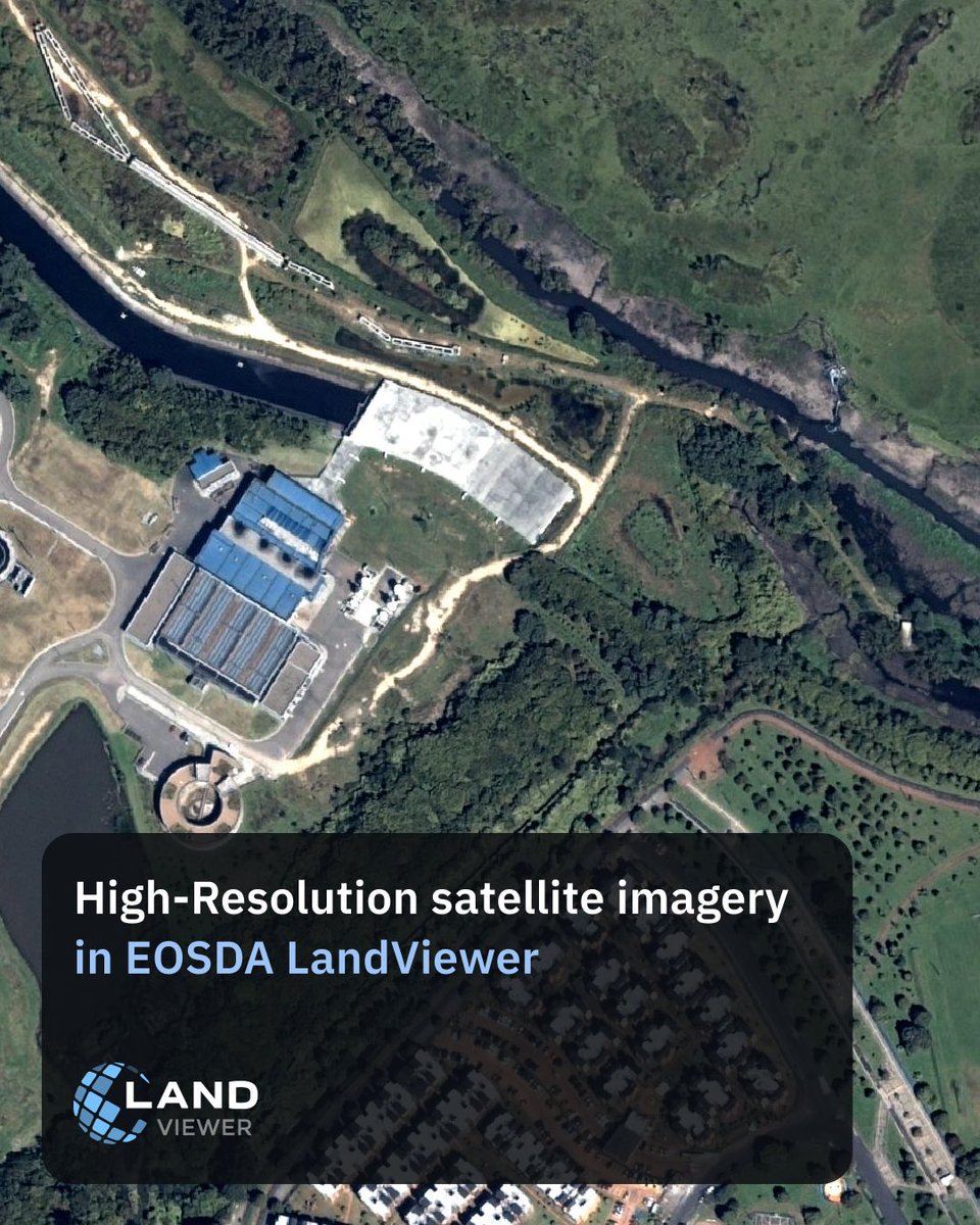
High-resolution satellite imagery lets you see what medium-resolution data often misses — individual buildings, roads, infrastructure, and small changes on the ground. Follow #EOSDA #LandViewer to see satellite imagery in action.
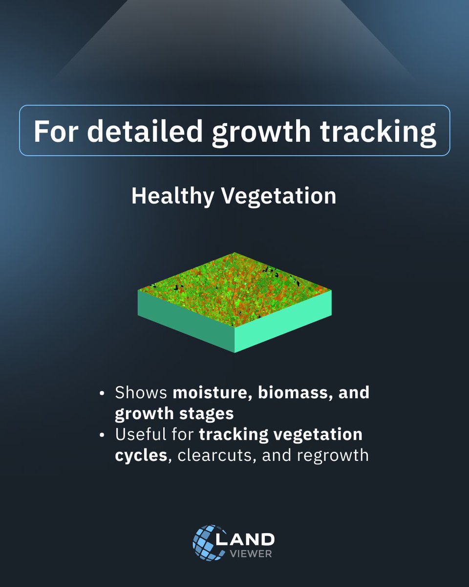
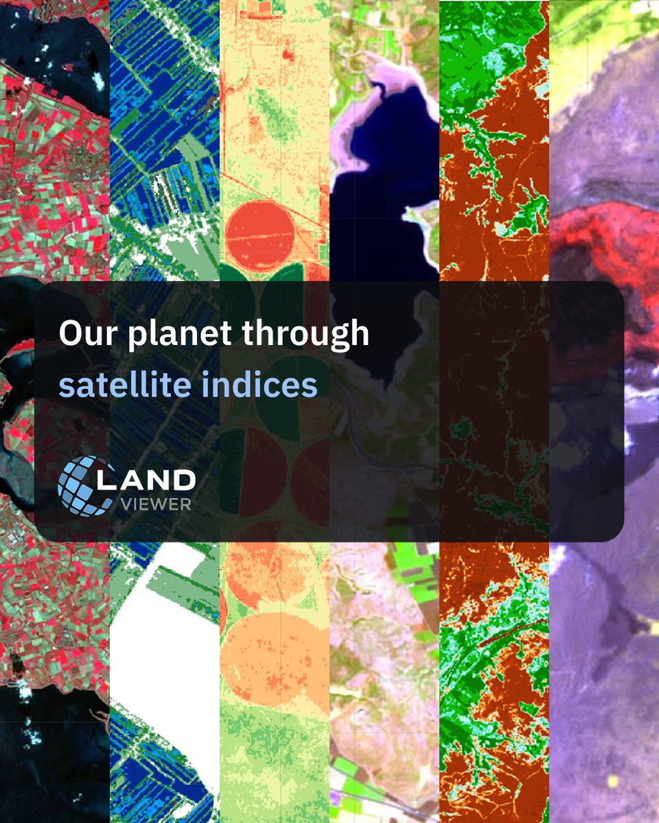
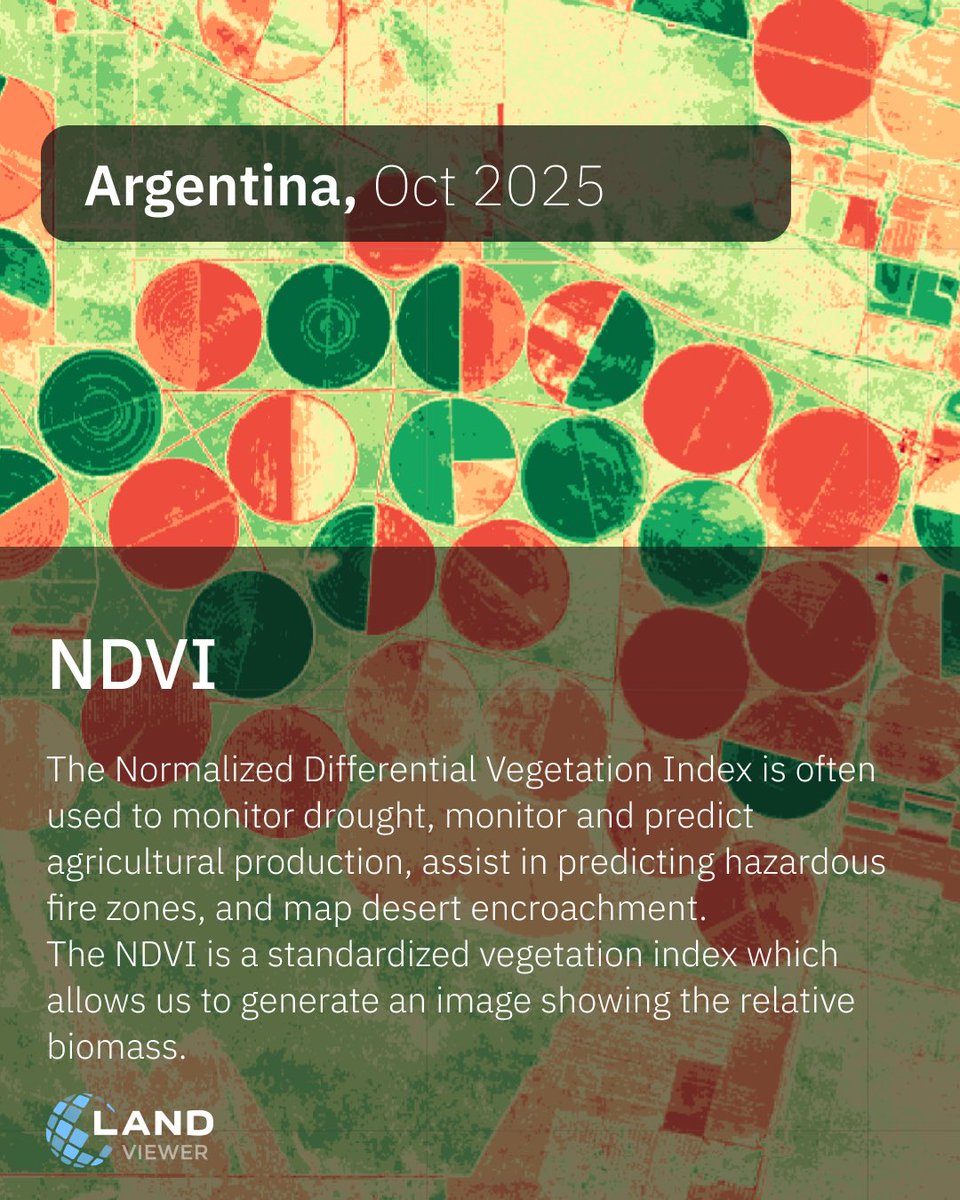
In #EOSDA LandViewer, you can look at vegetation using several indices at once 👉 All these indices are available in EOSDA #LandViewer: bit.ly/3KUrnMk If none of the standard options fit your task, you can also create a custom index tailored to your specific conditions.
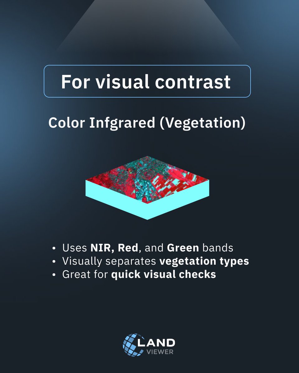


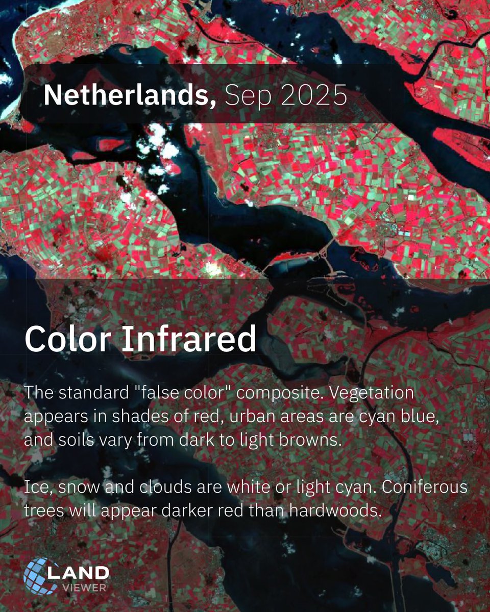
Valencia’s recent #flooding has left a lasting impact. With #ColorInfrared in EOSDA #LandViewer, we can see affected areas clearly: vegetation in red and urban structures highlighted. This index aids planners in assessing flood damage to green: bit.ly/3AiLD5f
Get EOSDA #LandViewer Pro Plan at a special Black Friday rate — available until November 28 📅 Monthly plan: $39.99 Annual plan: +3 extra months free Offer ends soon: bit.ly/3X0xkKd Terms and conditions details: eos.com/blog/landviewe…


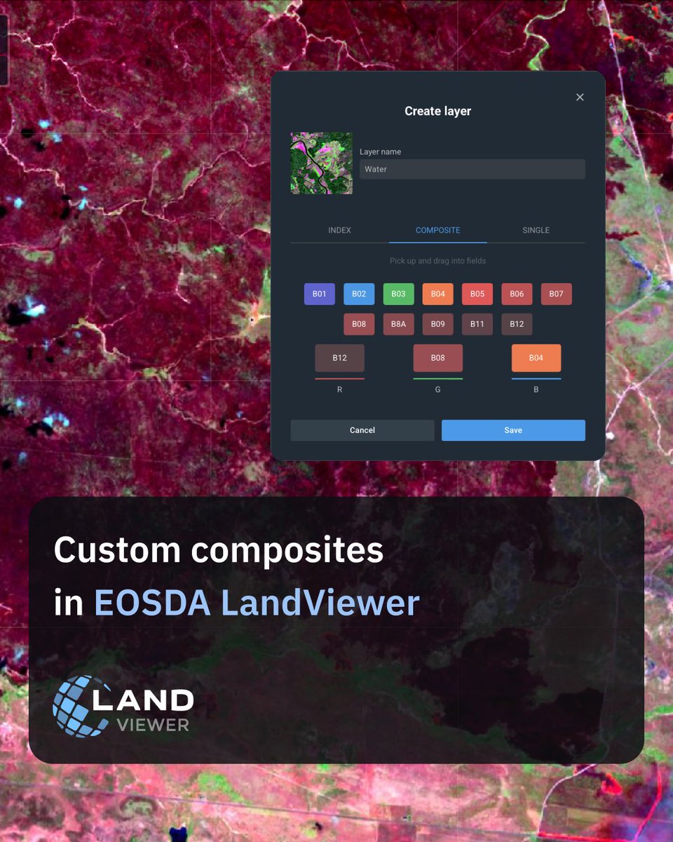
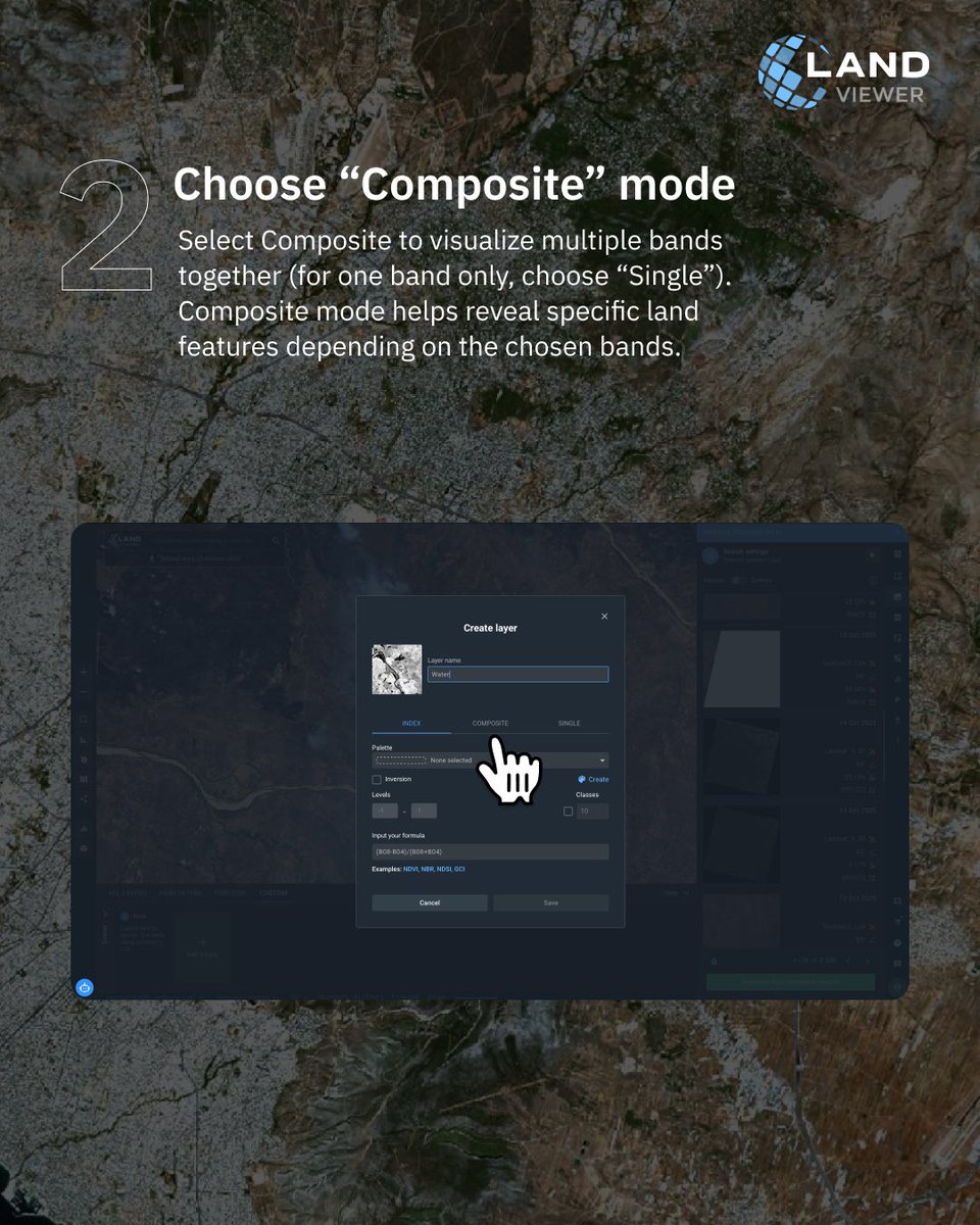
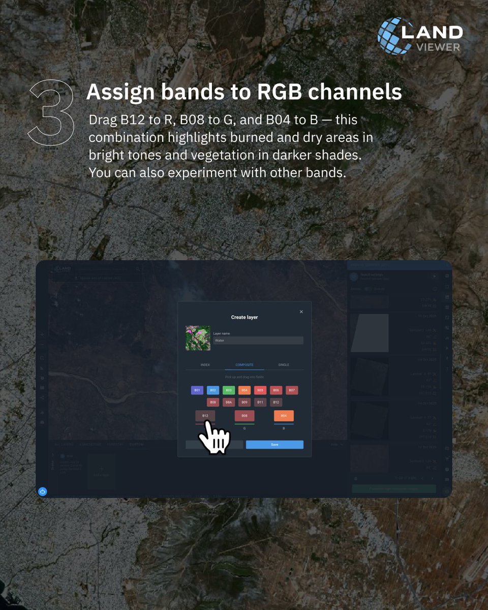
You can create a custom band combination in #EOSDA #LandViewer to highlight specific land features or patterns. In this example, the B12, B8A, and B04 composite helps visualize surface temperature and moisture variations. 🛰 Try it in EOSDA LandViewer: bit.ly/4qoBp8C
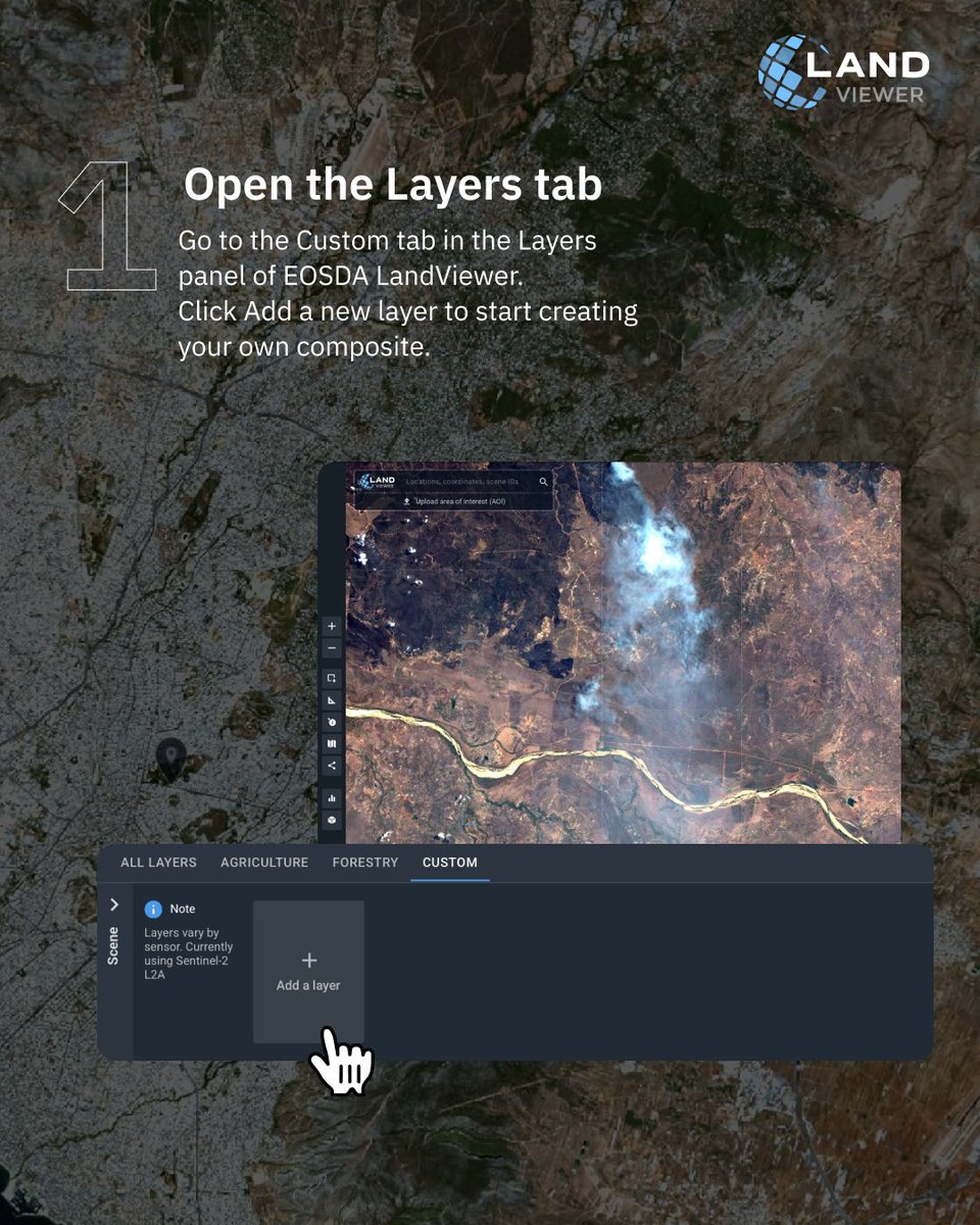
Meet the updated Layers in EOSDA #LandViewer. Analyzing your territory has never been easier. Sign up now and get full access to analysis tools: bit.ly/4m7wrtC ✅ #NDVI, #NDWI, #NDSI available for free after registration.

#GENSO #Metaverse #LANDViewer supports Japanese, English, Chinese and Korean. Find more on @genso_meta. Don't forget to follow our official @Twitter Tomorrow we have 1 English AMA on #TwitterSpace. #Web3 #game #blockchain #LAND #NFT

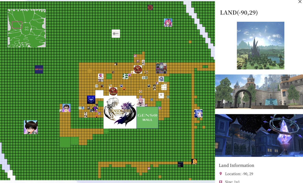
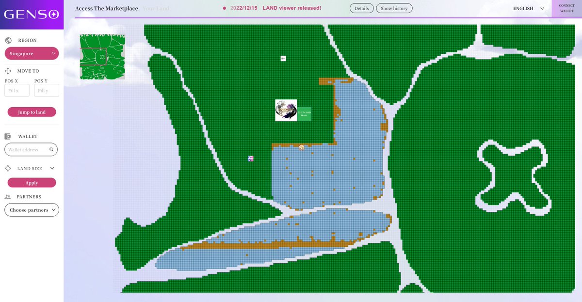
You may easily view the overall #LAND in #GensoMetaverse via #LANDViewer 🚀Yes! ❓What's the most important when you buy a property(House or LAND)? ❗️It's the #Location ✌️Location!Location!Location! @genso_meta Detail: sg-land.genso.game/home?currentX=… #元素騎士 #Game #Web3
Our thoughts are with those affected by the devastating #Palisadesfire, which has burned over 2,900 acres. Using #EOSDA #LandViewer with #AtmosphericRemoval band combination, responders can track fires and assess damage in real-time: bit.ly/3DJdJb3
Satellite imagery in EOSDA #LandViewer shows the recent activity of Mount #Semeru, Indonesia’s highest volcano. The eruption produced ash plumes and visible thermal anomalies around the summit area, helping analysts assess the extent of ongoing activity: bit.ly/4akakxs
In #EOSDA LandViewer, you can search satellite imagery by location and capture date — whether you need the most recent scene or historical data from years ago. Satellite imagery search in EOSDA #LandViewer is available after registration: eos.com/products/landv…
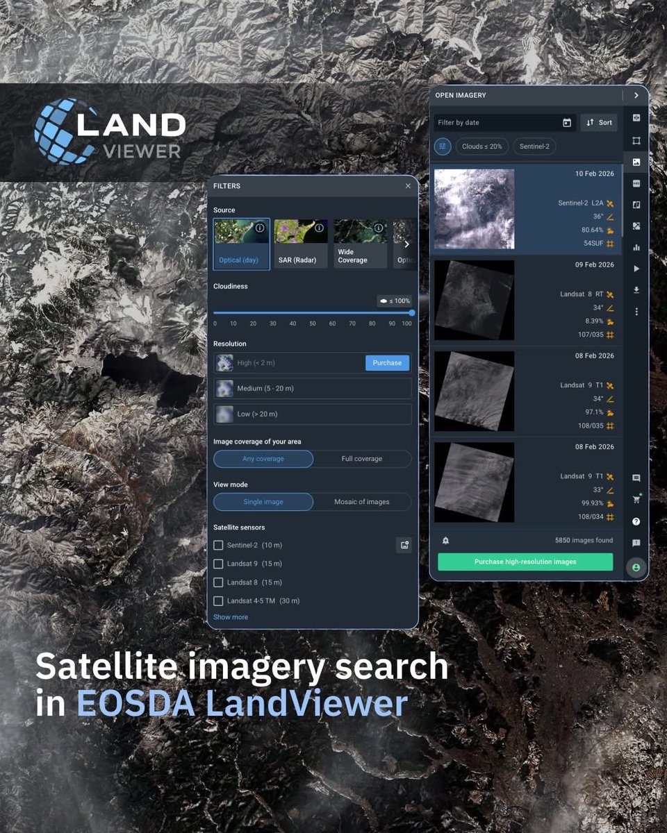
In #EOSDA LandViewer, you can search satellite imagery by location and capture date — whether you need the most recent scene or historical data from years ago. Satellite imagery search in EOSDA #LandViewer is available after registration: eos.com/products/landv…
High-resolution satellite imagery lets you see what medium-resolution data often misses — individual buildings, roads, infrastructure, and small changes on the ground. Follow #EOSDA #LandViewer to see satellite imagery in action.
❄ McMurdo Station is the largest research station on the continent and the main logistical hub for #Antarcticscience. High-resolution imagery available in #EOSDA #LandViewer: bit.ly/42yncLN

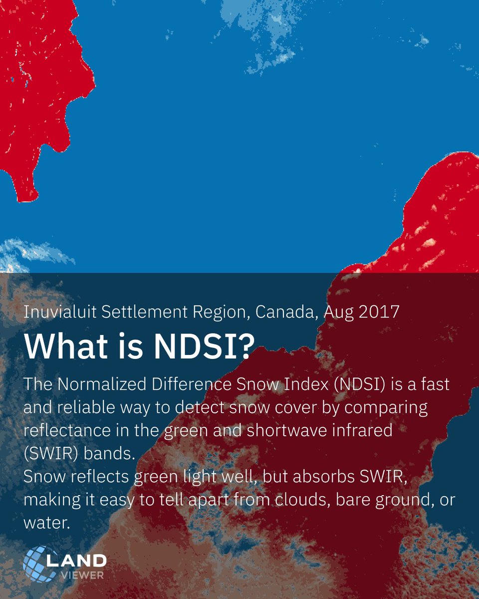
With NDSI in #EOSDA #LandViewer, you can: • Map snow cover and its extent • Distinguish snow from clouds with higher confidence • Track seasonal changes in snowpack • Support hydrological analysis ✅ Free after registration: bit.ly/4pz0aND


In #EOSDA LandViewer, you can look at vegetation using several indices at once 👉 All these indices are available in EOSDA #LandViewer: bit.ly/3KUrnMk If none of the standard options fit your task, you can also create a custom index tailored to your specific conditions.
Black Friday pricing ends in 48 hours. 📅 Get full access to #EOSDA #LandViewer at the lowest rate of the year — offer valid until November 28. Don’t miss your chance to start working with satellite data today. Your secret link: bit.ly/3X0xkKd
Satellite imagery in EOSDA #LandViewer shows the recent activity of Mount #Semeru, Indonesia’s highest volcano. The eruption produced ash plumes and visible thermal anomalies around the summit area, helping analysts assess the extent of ongoing activity: bit.ly/4akakxs
Get EOSDA #LandViewer Pro Plan at a special Black Friday rate — available until November 28 📅 Monthly plan: $39.99 Annual plan: +3 extra months free Offer ends soon: bit.ly/3X0xkKd Terms and conditions details: eos.com/blog/landviewe…
High-resolution satellite sensors provide enhanced spatial resolution for the most accurate, reliable, and timely data. With #EOSDA #LandViewer, you can easily purchase imagery from the world’s leading high-resolution satellite imagery providers: bit.ly/42yncLN
Win-win with #EOSDA #LandViewer! 🎁 Buy a monthly EOSDA LandViewer subscription between November 17–28 and get a chance to win a free upgrade to the full year of the Pro Plan! 📲 Enter now: bit.ly/3X0xkKd Terms and conditions details: eos.com/blog/landviewe…
With the Satellite Tasking feature in EOSDA #LandViewer, users can request future high-resolution captures for any location and receive exactly the data they need: bit.ly/4i21vuo Try the Satellite Tasking with EOSDA LandViewer 👈

EOSDA #LandViewer is further expanding its satellite data sources with the addition of #SpaceWill (new #SuperView Neo-1 and Neo-3 satellites) and Improsat (#Göktürk-1 satellite) imagery. Learn more: bit.ly/3JE1b84
High-resolution satellite sensors provide enhanced spatial resolution for the most accurate, reliable, and timely data. With #EOSDA #LandViewer, you can easily purchase imagery from the world’s leading high-resolution satellite imagery providers: bit.ly/42yncLN

You can create a custom band combination in #EOSDA #LandViewer to highlight specific land features or patterns. In this example, the B12, B8A, and B04 composite helps visualize surface temperature and moisture variations. 🛰 Try it in EOSDA LandViewer: bit.ly/4qoBp8C
🛰️ @BlackSky_Inc imagery now available in #EOSDA #LandViewer! Access submeter data and up to 15 revisits/day for time series, change detection & high-activity zone monitoring.📍 Try it: bit.ly/EOSDALandViewer
Meet the updated Layers in EOSDA #LandViewer. Analyzing your territory has never been easier. Sign up now and get full access to analysis tools: bit.ly/4m7wrtC ✅ #NDVI, #NDWI, #NDSI available for free after registration.
High-resolution satellite sensors provide enhanced spatial resolution for the most accurate, reliable, and timely data. With #EOSDA #LandViewer, you can easily purchase imagery from the world’s leading high-resolution satellite imagery providers: bit.ly/42yncLN
The Palace of #Versailles is one of the most iconic symbols of French history, architecture, and culture. With #EOSDA #LandViewer, you can explore the detailed layout of Versailles, and track changes over time using high-resolution #satellite imagery: bit.ly/42yncLN
Meet the updated Layers in EOSDA #LandViewer. Analyzing your territory has never been easier. Sign up now and get free access to analysis tools: bit.ly/4m7wrtC All indices are available right after you log into the platform. ✅ Try now:


High-resolution satellite sensors provide enhanced spatial resolution for the most accurate, reliable, and timely data. With #EOSDA #LandViewer, you can easily purchase imagery from the world’s leading high-resolution satellite imagery providers: bit.ly/42yncLN
Win-win with #EOSDA #LandViewer! 🎁 Buy a monthly EOSDA LandViewer subscription between November 17–28 and get a chance to win a free upgrade to the full year of the Pro Plan! 📲 Enter now: bit.ly/3X0xkKd Terms and conditions details: eos.com/blog/landviewe…
Black Friday pricing ends in 48 hours. 📅 Get full access to #EOSDA #LandViewer at the lowest rate of the year — offer valid until November 28. Don’t miss your chance to start working with satellite data today. Your secret link: bit.ly/3X0xkKd
All #GENSO #LAND owners could use #LANDViewer to check the location of your LANDs anytime. 🔭LAND viewer: bit.ly/3XnyJsa You may find #LAND on the secondary market if you have yet to buy it. 🚩 market.genso.game/marketplace/la… Let's build a wonderful #metaverse with
In #EOSDA LandViewer, you can look at vegetation using several indices at once 👉 All these indices are available in EOSDA #LandViewer: bit.ly/3KUrnMk If none of the standard options fit your task, you can also create a custom index tailored to your specific conditions.
🛰️ @BlackSky_Inc imagery now available in #EOSDA #LandViewer! Access submeter data and up to 15 revisits/day for time series, change detection & high-activity zone monitoring.📍 Try it: bit.ly/EOSDALandViewer
Get EOSDA #LandViewer Pro Plan at a special Black Friday rate — available until November 28 📅 Monthly plan: $39.99 Annual plan: +3 extra months free Offer ends soon: bit.ly/3X0xkKd Terms and conditions details: eos.com/blog/landviewe…
The Palace of #Versailles is one of the most iconic symbols of French history, architecture, and culture. With #EOSDA #LandViewer, you can explore the detailed layout of Versailles, and track changes over time using high-resolution #satellite imagery: bit.ly/42yncLN
#GENSO #Metaverse #LANDViewer supports Japanese, English, Chinese and Korean. Find more on @genso_meta. Don't forget to follow our official @Twitter Tomorrow we have 1 English AMA on #TwitterSpace. #Web3 #game #blockchain #LAND #NFT
High-resolution satellite imagery lets you see what medium-resolution data often misses — individual buildings, roads, infrastructure, and small changes on the ground. Follow #EOSDA #LandViewer to see satellite imagery in action.
Meet the updated Layers in EOSDA #LandViewer. Analyzing your territory has never been easier. Sign up now and get full access to analysis tools: bit.ly/4m7wrtC ✅ #NDVI, #NDWI, #NDSI available for free after registration.
EOSDA #LandViewer is further expanding its satellite data sources with the addition of #SpaceWill (new #SuperView Neo-1 and Neo-3 satellites) and Improsat (#Göktürk-1 satellite) imagery. Learn more: bit.ly/3JE1b84
Want to take your #land monitoring to the next level? With #EOSDA #LandViewer's high-resolution #satelliteimagery, you can unlock detailed insights into your fields, forests, and beyond. #Monitor crops, track vegetation changes, and make precise decisions: bit.ly/4gFSh57
In #EOSDA LandViewer, you can search satellite imagery by location and capture date — whether you need the most recent scene or historical data from years ago. Satellite imagery search in EOSDA #LandViewer is available after registration: eos.com/products/landv…
You can create a custom band combination in #EOSDA #LandViewer to highlight specific land features or patterns. In this example, the B12, B8A, and B04 composite helps visualize surface temperature and moisture variations. 🛰 Try it in EOSDA LandViewer: bit.ly/4qoBp8C
With the Satellite Tasking feature in EOSDA #LandViewer, users can request future high-resolution captures for any location and receive exactly the data they need: bit.ly/4i21vuo Try the Satellite Tasking with EOSDA LandViewer 👈
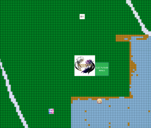
You may easily view the overall #LAND in #GensoMetaverse via #LANDViewer 🚀Yes! ❓What's the most important when you buy a property(House or LAND)? ❗️It's the #Location ✌️Location!Location!Location! @genso_meta Detail: sg-land.genso.game/home?currentX=… #元素騎士 #Game #Web3
With NDSI in #EOSDA #LandViewer, you can: • Map snow cover and its extent • Distinguish snow from clouds with higher confidence • Track seasonal changes in snowpack • Support hydrological analysis ✅ Free after registration: bit.ly/4pz0aND
❄ McMurdo Station is the largest research station on the continent and the main logistical hub for #Antarcticscience. High-resolution imagery available in #EOSDA #LandViewer: bit.ly/42yncLN
Data Clustering in #EOSDA #LandViewer — free after registration: bit.ly/3KHP2PW Analyze your AOI, set cluster parameters, and let the tool automatically create color-coded zones and downloadable shapefiles for deeper mapping and reporting:

Something went wrong.
Something went wrong.
United States Trends
- 1. #Verzuz N/A
- 2. Tyrese N/A
- 3. Purdue N/A
- 4. Trey Songz N/A
- 5. Iowa N/A
- 6. Nebraska N/A
- 7. Jamie Foxx N/A
- 8. #iHeartAwards2026 N/A
- 9. Sweet Lady N/A
- 10. Elite 8 N/A
- 11. Ben McCollum N/A
- 12. #thepitt N/A
- 13. #911onABC N/A
- 14. Chase DeLauter N/A
- 15. Andy Pages N/A
- 16. #ENHYPEN_IS_7 N/A
- 17. Go Hawks N/A
- 18. Maybe I Deserve N/A
- 19. Hornets N/A
- 20. Brendan Donovan N/A