#satellite search results

Amazon has agreed to acquire satellite communications company Globalstar. The deal provides access to Globalstar’s satellites, infrastructure, and spectrum licenses to support Amazon’s Project Kuiper satellite internet initiative. #Amazon #Globalstar #Satellite


Important lesson Dakota learned in therapy recently: treat relationships, work, and hobbies as satellites, not lifelines. They should guide and illuminate your path, not be something to cling to desperately. #mentalhealth #motivation #satellite

#SouthKorea launches next-generation #satellite on SpaceX #Falcon9 #SpaceX launched a Falcon 9 rocket from Vandenberg Space Force Base in Santa Barbara County, #California, at 11:59 p.m. Saturday (local time), carrying 45 payloads.


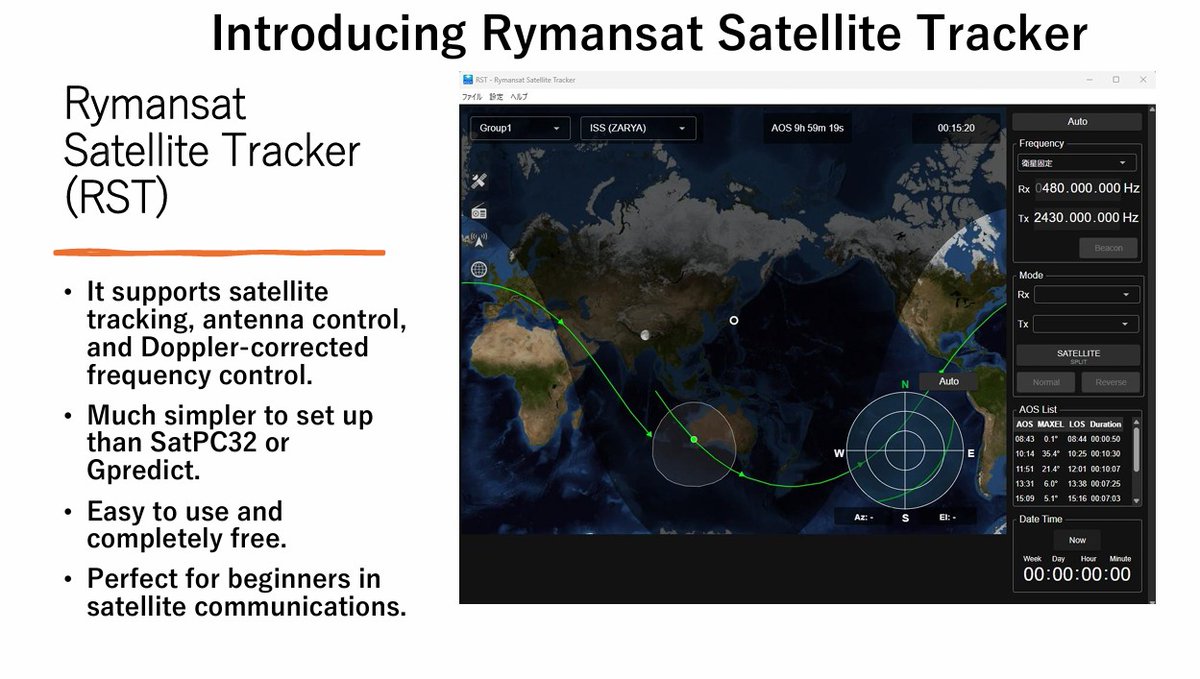
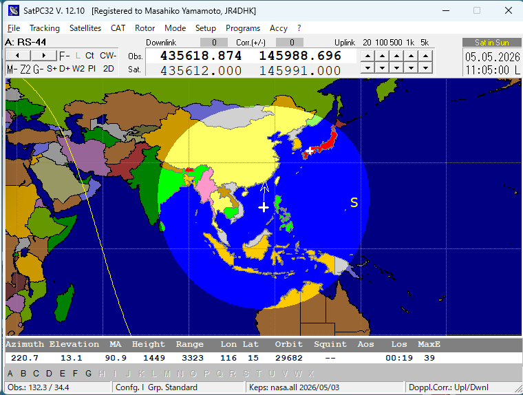
New satellite‑tracking software by Japan’s Rymansat Group. Works FB on XU7. Few supported radios/rotators, but very easy to set up. FT4 becomes simple when used with WSJT. Enjoy LEO QSO. Manual bit.ly/49aeSoQ Download bit.ly/427Un8u #satellite #LEO #FT4

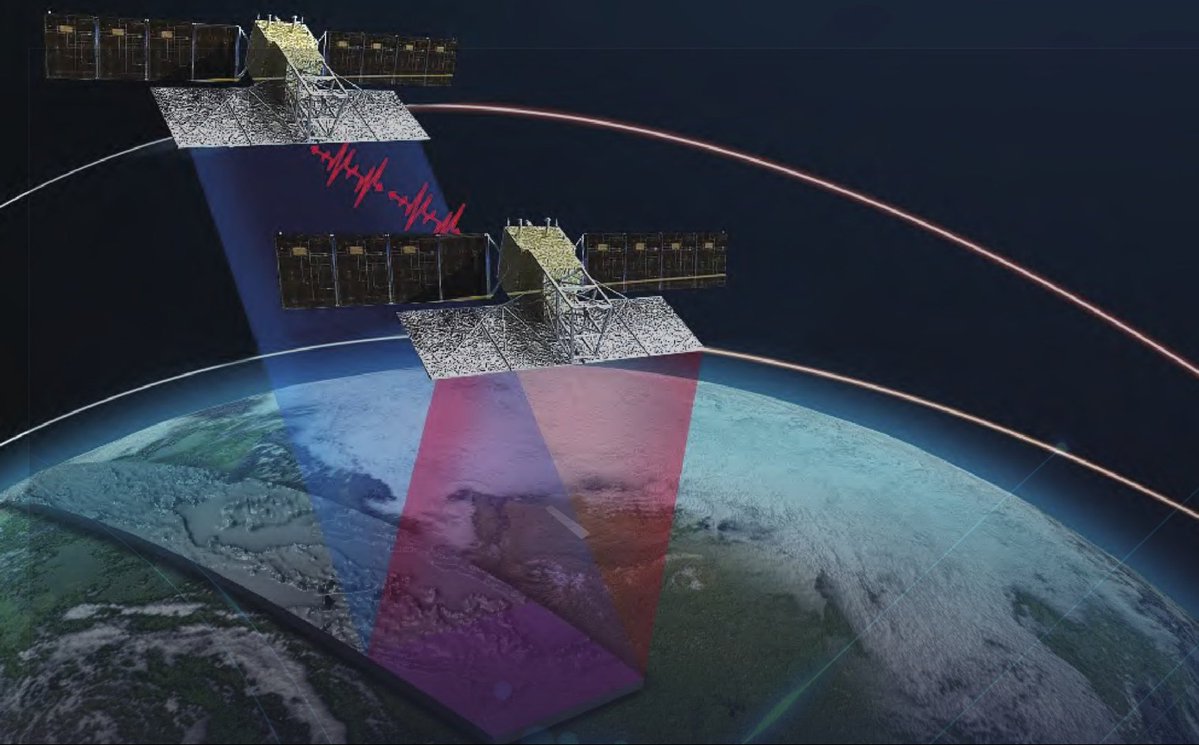
🛰️ Che cos’è il SAR, il radar satellitare che vede la Terra senza luce? 📺 Scoprilo nel video su AsiTv: ow.ly/83YT50YUPFj 🎧 Oppure ascolta la versione audio: ow.ly/oI8B50YUPFq #Sar #satelliti #satellite #radar #CosmoSkyMed #Iride


Important lesson Dakota learned in therapy recently: treat relationships, work, and hobbies as satellites, not lifelines. They should guide and illuminate your path, not be something to cling to desperately. #mentalhealth #motivation #satellite

Nový hráč na obloze! 🛰️ Basalt Space umožňuje ovládat vlastní satelitní konstelace, čímž snižuje náklady a zrychluje přístup k datům. Budoucnost zemědělství, komunikací a zpravodajství je tady. Revoluce v satelitních technologiích! #SpaceTech #Satellite


Buoyed by its success with the Mission Drishti satellite, Bengaluru-based space start-up GalaxEye Space Solutions Private Ltd plans to continue expanding its satellite constellation over the next five years, writes Venkatachari Jagannathan. #India #GalaxEye #Satellite


🔻 REENTRY ALERT | GHOST-1 🛰️ Type: Satellite ⏰ Expected: < 48 HOURS 📍 Current altitude: ~201 km 📡 NORAD ID: 56195 #reentry #space #satellite

📡 Software Defined Radio for satellites Compact, flexible, FPGA‑based SDR solutions for LEO missions. 👉 Meet DAVE Embedded Systems at Space Meetings Veneto #SDR #Satellite #NewSpace

Lost Green? 🌍 How to Detect #Vegetation Loss Using #Satellite Data? Join our live online training program starting 9th May 2026, and gain hands-on expertise in cloud-based geospatial analysis using #GoogleEarthEngine, seamlessly integrated with desktop #GIS platforms.

Швеция запустила первый военный спутник и планирует до 10 аппаратов на орбите. Цель — собственная разведка и мониторинг региона. sat-one.info/87588-n.html #space #satellite


🌏🛰️ #Deformation #Slope Extraction and Influencing Factor Analysis Using LT-1 #Satellite #Data: A Case Study of Chongqing and Surrounding Areas, #China ✍️ Jielin Liu et al. 🔗 brnw.ch/21x1wnK

OroraTech Launches Greek Fire Sats OroraTech deploys the first national wildfire #satellite system. Real-time thermal data now covers 100% of #Greece. 🔗 Read: spacewatch.global/2026/05/greece… #SpaceWatchNews #Wildfires @OroraTech


A bad development. Better satellite coverage gives Iran a sharper picture of U.S. bases, ships, and weak points across the region. Better targeting overseas can put more Americans in harm’s way fast. #iran #spytactics #satellite #surveillance share.google/J82wTXG8eYbHaw…

#Sweden has launched the first military #satellite to spy on #Russia. The device was launched into orbit from a base in California with the participation of #SpaceX. It will become part of a future constellation of military satellites that will track targets and movements.

🔻 REENTRY ALERT | ASTROCAST-0103 🛰️ Type: Satellite ⏰ Expected: IMMINENT 📍 Current altitude: ~199 km ⚠️ Reentry imminent — tracking closely 📡 NORAD ID: 47487 #reentry #space #satellite
🚨 COLLISION WARNING 🛰️ DMSP 5D-2 F13 DEB × OSCAR 3 📊 Probability: 1 in 1,193 📏 Miss distance: 517 m ⏰ TCA: ~2 days #conjunction #space #satellite
🔻 REENTRY ALERT | JILIN-1 GAOFEN 03D18 🛰️ Type: Satellite ⏰ Expected: < 24 HOURS 📍 Current altitude: ~194 km ⚠️ Reentry imminent — tracking closely 📡 NORAD ID: 51844 #reentry #space #satellite
🚨 COLLISION WARNING 🛰️ NOAA 17 × UNKNOWN 📊 Probability: 1 in 1,199 📏 Miss distance: 87 m 🟠 TCA: ~17 hours #conjunction #space #satellite
Amazon has agreed to acquire satellite communications company Globalstar. The deal provides access to Globalstar’s satellites, infrastructure, and spectrum licenses to support Amazon’s Project Kuiper satellite internet initiative. #Amazon #Globalstar #Satellite
#SouthKorea launches next-generation #satellite on SpaceX #Falcon9 #SpaceX launched a Falcon 9 rocket from Vandenberg Space Force Base in Santa Barbara County, #California, at 11:59 p.m. Saturday (local time), carrying 45 payloads.

#News #Satellite (Hotbird 13° Est): Novità sulla frequenza DVB-S2 10930 H 30000 2/3. Eliminato il canale "Juwelo TV". sites.google.com/view/alessandr…
#News #Satellite (Hotbird 13° Est): Novità per "RADIONORBA TV" (HD) canale presente sulla frequenza DVB-S2 11373 H 27500 3/4 e sulla frequenza DVB-S2 11919 V 29900 3/4. Da questi mattina la barra delle notizie di Mediaset semberebbe essere stata... sites.google.com/view/alessandr…
Some really interesting data points and commentary in the #satellite session at @WIAorg @ConnectX_USA yesterday, especially about #D2D About 0.5% of US smartphones connect monthly to satellite services, but it's quite variable linkedin.com/posts/deanbubl…


─────⊹⊱✙⊰⊹───── ♰5月ゲスト出勤 ♰ 5月23日 20時〜25時(最終入店24時) ♰スズキ(仮称)ゲスト出勤♰ 【 @u_noxiii 】 ─────⊹⊱✙⊰⊹───── #サテラ #satellite #メンズラウンジ #メンズコンカフェ #歌舞伎町

─────⊹⊱✙⊰⊹───── ✔︎サテラ 【発表しますっ✨】 vt.tiktok.com/ZS949QHaM/ ─────⊹⊱✙⊰⊹───── #サテラ #satellite #歌舞伎町 #メンズコンカフェ #メンズラウンジ

OroraTech Launches Greek Fire Sats OroraTech deploys the first national wildfire #satellite system. Real-time thermal data now covers 100% of #Greece. 🔗 Read: spacewatch.global/2026/05/greece… #SpaceWatchNews #Wildfires @OroraTech

Viasat's ViaSat-3 F3 has reached orbit after a SpaceX launch, with more than 1 terabit per second of capacity planned for Asia-Pacific users. #Viasat #SpaceX #Satellite #AsiaPacific techday.com.au/story/viasat-l…

📡 Software Defined Radio for satellites Compact, flexible, FPGA‑based SDR solutions for LEO missions. 👉 Meet DAVE Embedded Systems at Space Meetings Veneto #SDR #Satellite #NewSpace
🛰️ Che cos’è il SAR, il radar satellitare che vede la Terra senza luce? 📺 Scoprilo nel video su AsiTv: ow.ly/83YT50YUPFj 🎧 Oppure ascolta la versione audio: ow.ly/oI8B50YUPFq #Sar #satelliti #satellite #radar #CosmoSkyMed #Iride

Bengaluru startup GalaxEye launches world’s first OptoSAR satellite #GalaxEye #SpaceTech #Satellite #Bengaluru #Innovation #ISRO #newskarnataka newskarnataka.com/s/6wq0zh
newskarnataka.com
Bengaluru startup GalaxEye launches world’s first OptoSAR satellite
GalaxEye’s Mission Drishti marks a breakthrough with the launch of the world’s first OptoSAR imaging satellite, blending optical and SAR capabilities.

Spire Global loses contract worth 9 months of 2025 revenue. SPIR stock plunges in after-hours trading. Can the company recover from this blow? #SPIR #Satellite #Space

.@davidicke Mind-control works exactly like you described it. I was mind-controlled to hit my roomate. He e was mind-controlled too to stalk me for months #Satellite #HavanaSyndrome "Trump Assassination Attempts" youtu.be/_dNRX79SuzA?si… @RepLuna @RepTimBurchett @RealCandaceO

youtube.com
YouTube
David Icke
Planet Labs (PL) targets bigger opportunities in Earth observation as demand for satellite data surges from governments and enterprises. Analysts see growth potential despite tech sector volatility. Can PL navigate market headwinds to capitalize? #PlanetLabs #Satellite #Tech
🛰️ ISS VISIBLE TONIGHT | May 05 📍 London, Paris ⏰ 02:50 UTC | 10 min pass ✨ bright (mag -2.4) 👀 Look WNW → moves ESE 🔭 Passes nearly overhead! #ISS #space #satellite

The EO-3 satellite launch marks Pakistan’s entry into China’s “Space Silk Road,” signaling a shift from dependency to strategic technological integration. #EO3 #Satellite #PakistanChina #SpacePartnership stratheia.com/the-space-silk…

#News #Satellite (Hotbird 13° Est): Novità per "RADIONORBA TV" (HD) canale presente sulla frequenza DVB-S2 11373 H 27500 3/4 e sulla frequenza DVB-S2 11919 V 29900 3/4. Nel pomeriggio sono continuati i test per l'inserimento della barra delle notizie di... sites.google.com/view/alessandr…


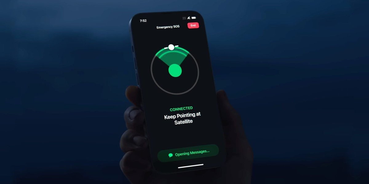
Apple leads the satellite smartphone market with 71.6% share in 2025. Broader use cases and mid-tier expansion are key to future growth. Link: thedailytechfeed.com/apple-leads-sa… #Apple #Satellite #Smartphone #Market #Innovation #Technology #Growth #Expansion #MidTier #Future #Trends


How dual-use satellites are blurring the lines of modern space war :An informative article by Ms Shrawani Shagun #Space #CriticalInfrastructure #Satellite #DualUse #Civilian #Military #OrbitalConflict #Jamming #Spoofing #GroundStationHacking #CyberAttacks #CyberSecurity #UPSC

🛰️ Che cos’è il SAR, il radar satellitare che vede la Terra senza luce? 📺 Scoprilo nel video su AsiTv: ow.ly/83YT50YUPFj 🎧 Oppure ascolta la versione audio: ow.ly/oI8B50YUPFq #Sar #satelliti #satellite #radar #CosmoSkyMed #Iride
🌧️🛰️ #Bayesian Model Averaging for #Satellite #Precipitation #Data Fusion: From Accuracy Estimation to Runoff Simulation ✍️ Shaowei Ning et al. 🔗 brnw.ch/21x1TPG


#Satellite #TestCentre: #Rheinmetall and the #Norwegian municipality of Andøy sign a #MoU for an integrated processing #facility rheinmetall.com/en/media/news-…


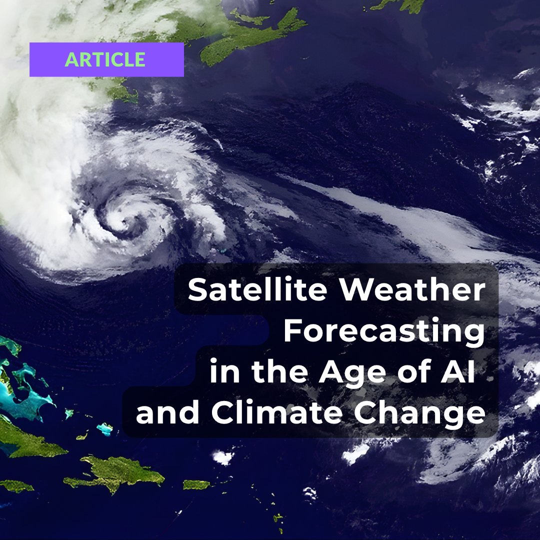
Weather forecasting feels simple. Open an app, check the icon. But behind that icon is one of the most complex data pipelines on Earth — and it's being rebuilt from the ground up. geoawesome.com/satellite-weat… #GeoAI #EarthObservation #Satellite #WeatherForecasting


OroraTech Launches Greek Fire Sats OroraTech deploys the first national wildfire #satellite system. Real-time thermal data now covers 100% of #Greece. 🔗 Read: spacewatch.global/2026/05/greece… #SpaceWatchNews #Wildfires @OroraTech

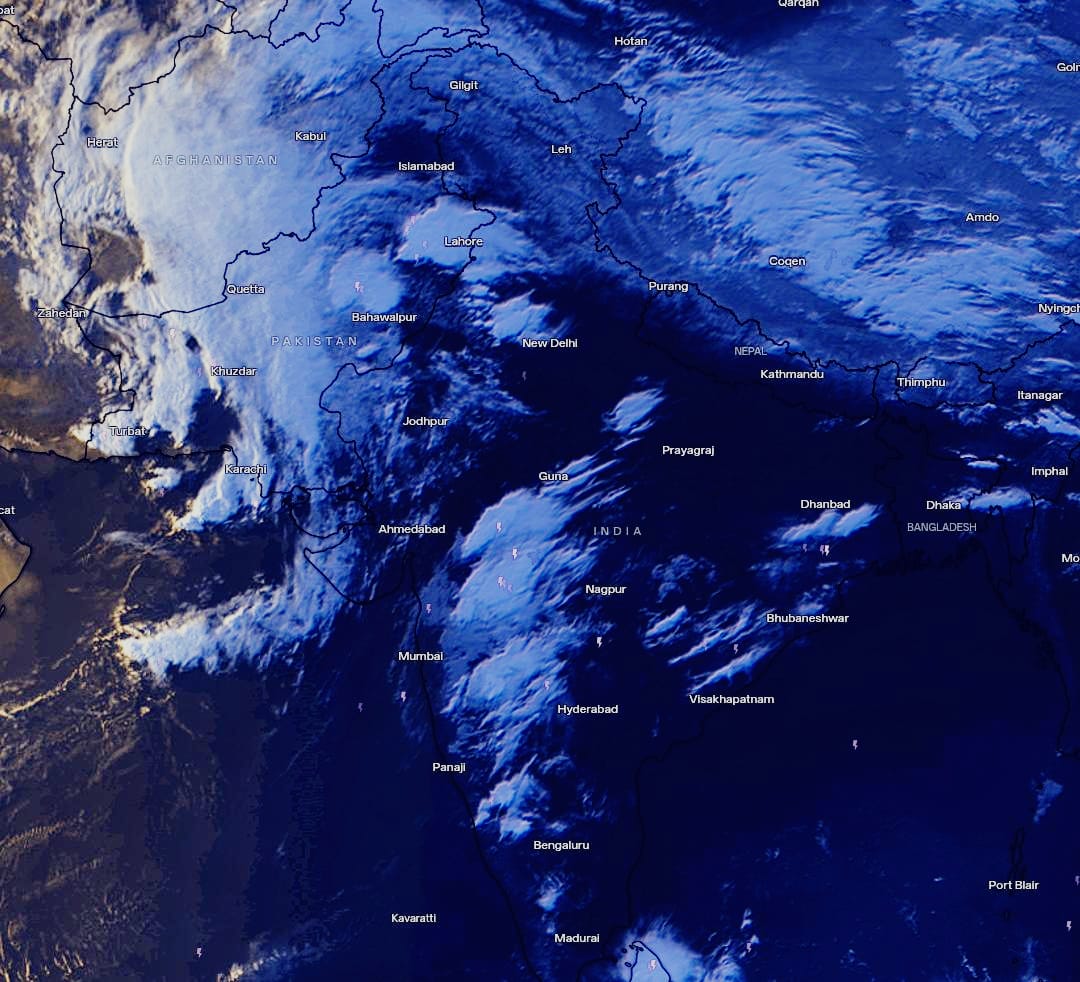
😳The #satellite imagery is quite striking showing the sheer power of the current Western Disturbance #Massive clusters of intense thunderstorms have formed Over Different areas causing widespread destruction across Rajasthan today while Pune witnessed record-breaking all time
🌏🛰️ #Deformation #Slope Extraction and Influencing Factor Analysis Using LT-1 #Satellite #Data: A Case Study of Chongqing and Surrounding Areas, #China ✍️ Jielin Liu et al. 🔗 brnw.ch/21x1wnK

#China plans to launch the world's first geostationary microwave atmospheric sounding #satellite during the 15th Five-Year Plan period (2026-30) to support more precise monitoring and warnings of extreme weather, officials with the China Meteorological Administration said on

🖼️🛰️ MBGPIN: Multi-Branch #Generative Prior #Integration Network for Super-Resolution #Satellite #Imagery ✍️ Furkat Safarov et al. 🔗 brnw.ch/21x1rMJ


🛰️ Turkish #defense giant #Aselsan has begun offering uninterrupted, wide bandwidth and ultra-secure military #satellite voice, data & live streaming communications services over the #Turksat constellation, covering most of the world's population centers. 🇹🇷

#SouthKorea launches next-generation #satellite on SpaceX #Falcon9 #SpaceX launched a Falcon 9 rocket from Vandenberg Space Force Base in Santa Barbara County, #California, at 11:59 p.m. Saturday (local time), carrying 45 payloads.
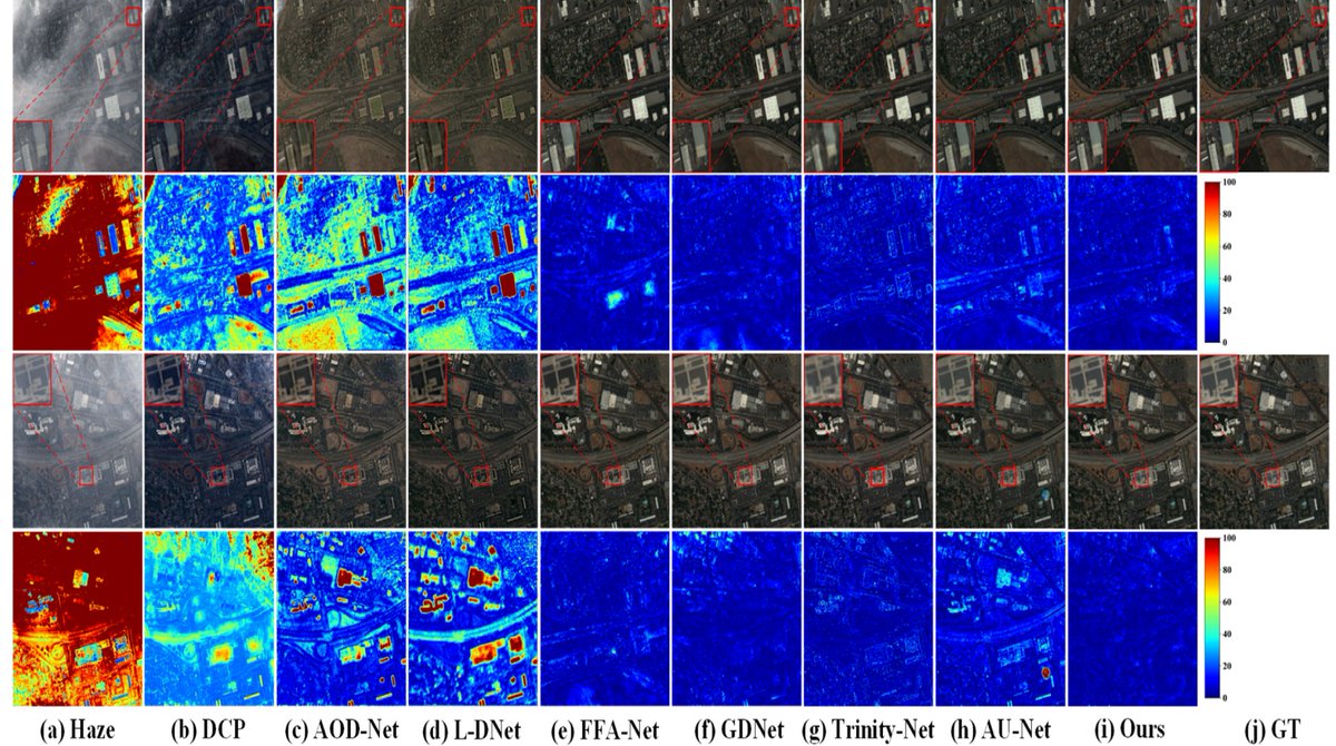
🖼️🖼️ U-Shaped Dual Attention #Vision #Mamba Network for #Satellite Remote Sensing Single-Image #Dehazing ✍️ Tangyu Sui et al. 🔗 brnw.ch/21x1pwg

FCC Seeks Comment on Satellite Market Access Reciprocity natlawreview.com/article/fcc-se… #FCC #satellite #market #reciprocity @GT_Law

New satellite‑tracking software by Japan’s Rymansat Group. Works FB on XU7. Few supported radios/rotators, but very easy to set up. FT4 becomes simple when used with WSJT. Enjoy LEO QSO. Manual bit.ly/49aeSoQ Download bit.ly/427Un8u #satellite #LEO #FT4
🌿🛰️ #Satellite-Observed Arid #Vegetation Greening and #Terrestrial #Water Storage Decline in the Hexi Corridor, Northwest #China ✍️ Chunyan Cao et al. 🔗 brnw.ch/21x1TTt


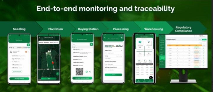
$DMTR Dimitra's AI insights can analyze environmental conditions, helping farmers see potential disease risks, soil problems or weather related threats before they affect production. #Satellite monitoring & digital farm mapping allow farms to be measured & analyzed at scale $BTC


🌀🛰️ Review of Assimilating Spaceborne #Global #Navigation #Satellite #System Remote Sensing Data for #Tropical# Cyclone Forecasting ✍️ Weihua Bai et al. 🔗 brnw.ch/21x1vpv

Something went wrong.
Something went wrong.
United States Trends
- 1. Happy Cinco de Mayo N/A
- 2. Good Tuesday N/A
- 3. #SAHA2026 N/A
- 4. Coinbase N/A
- 5. #ElRenacerDeVenezuela N/A
- 6. Tina Charles N/A
- 7. Travis Kelce N/A
- 8. Sam Smith N/A
- 9. Odyssey N/A
- 10. Battle of Puebla N/A
- 11. #WUTheSeriesEP1 N/A
- 12. #TeacherAppreciationWeek2026 N/A
- 13. Happy Taco N/A
- 14. Victor Hedman N/A
- 15. #TuesdayMotivation N/A
- 16. Helen of Troy N/A
- 17. Odysseus N/A
- 18. Christopher Nolan N/A
- 19. Sarah Paulson N/A
- 20. José "Piculín" Ortiz N/A