#pix4dreact 검색 결과

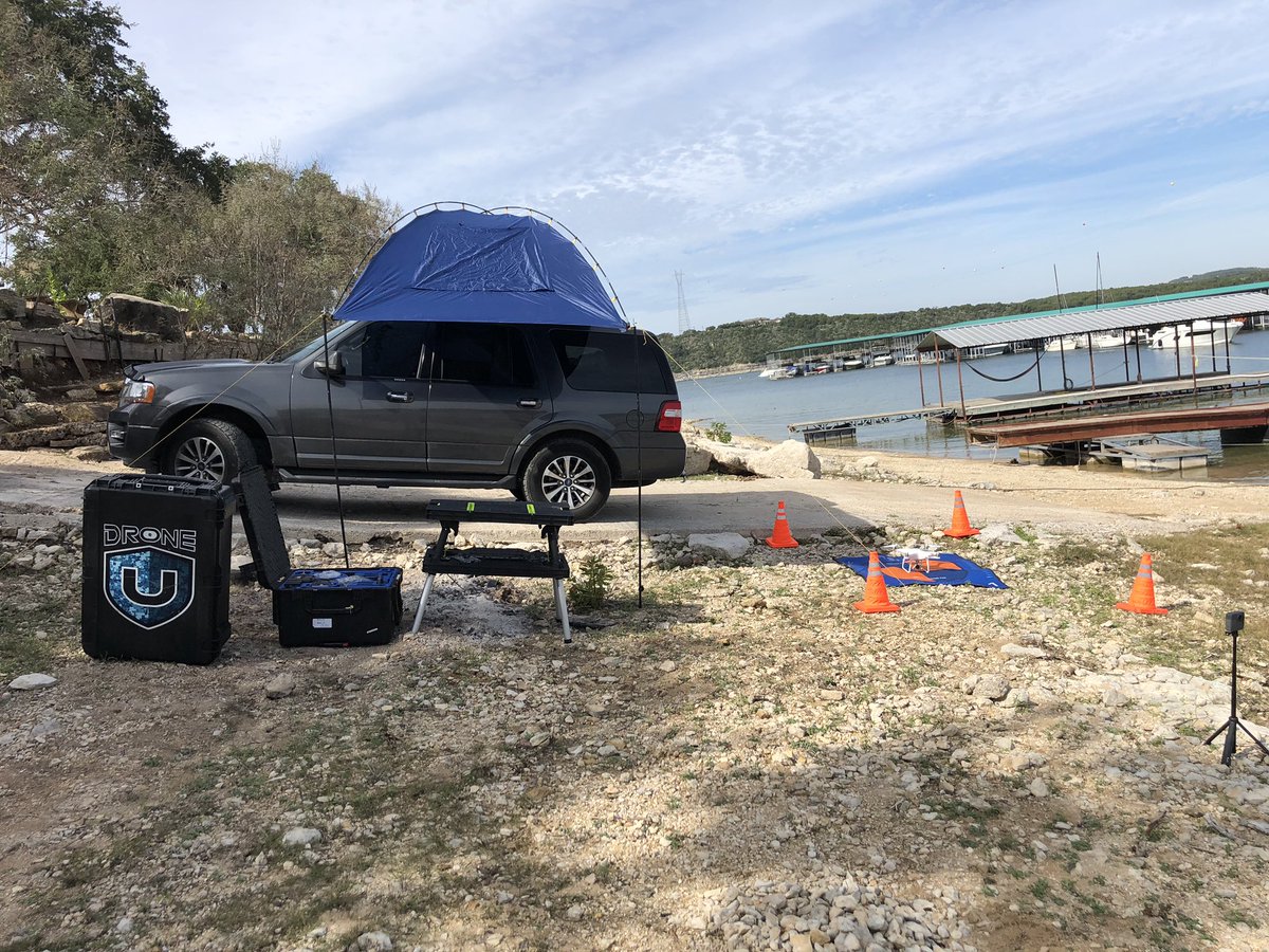
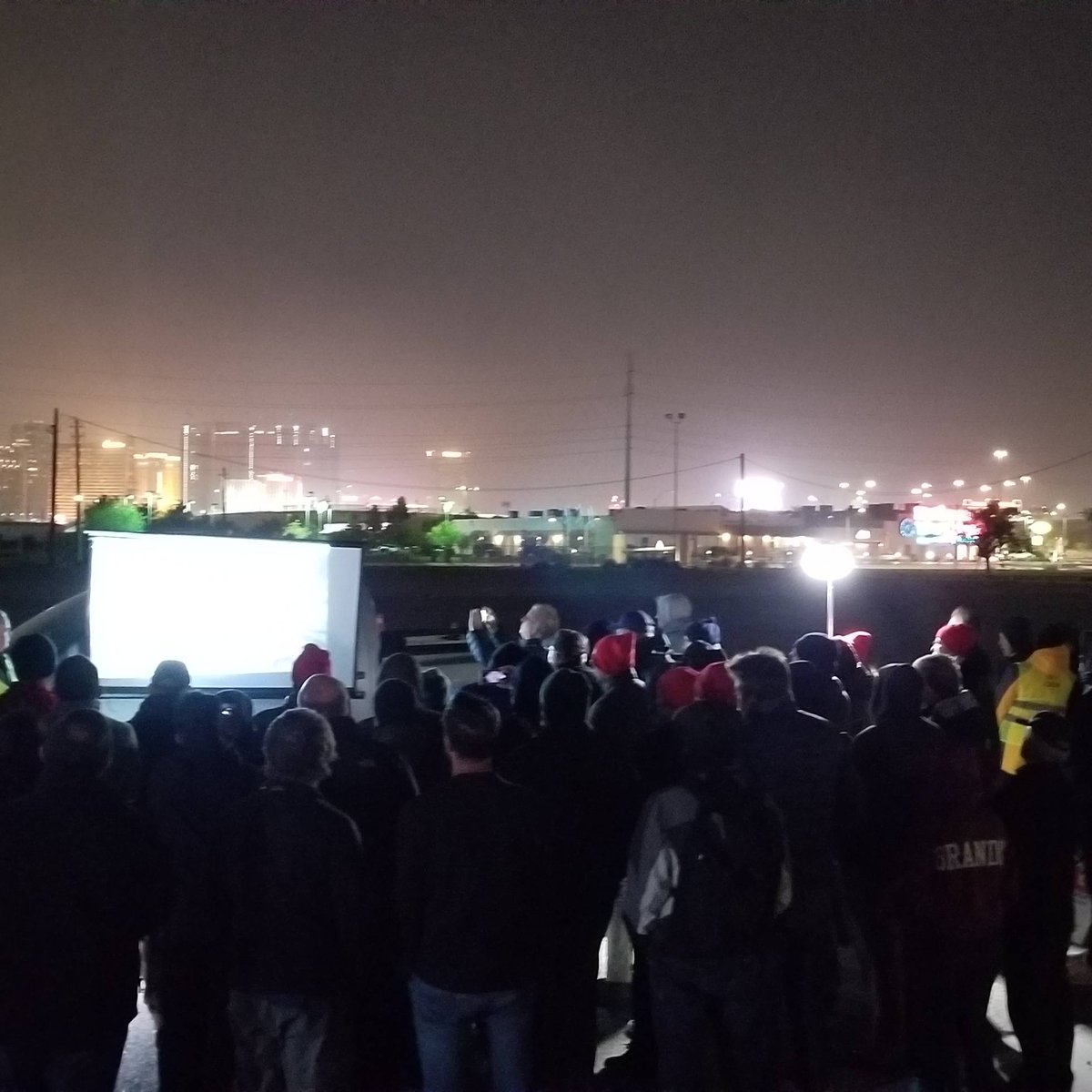
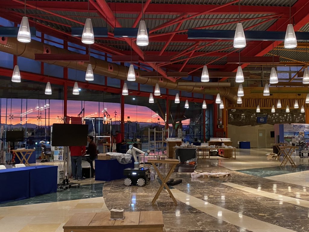
Here’s a look at at the classroom section of the #pix4dreact workshop presented by @pix4d and @Parrot!


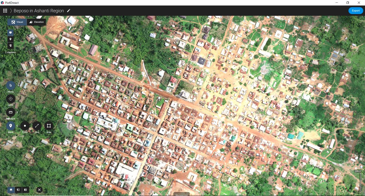
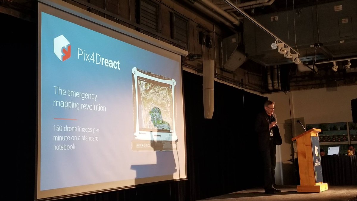
So far #Pix4Dreact from @pix4d is the #fastest 2D #processing soft we have used, thanks to @gab_rug for the intro. It's super #fast, works #offline with #exporting #annotation & #reporting capabilities. In less than an #hour, we #processed over 1600 #images of our project site.


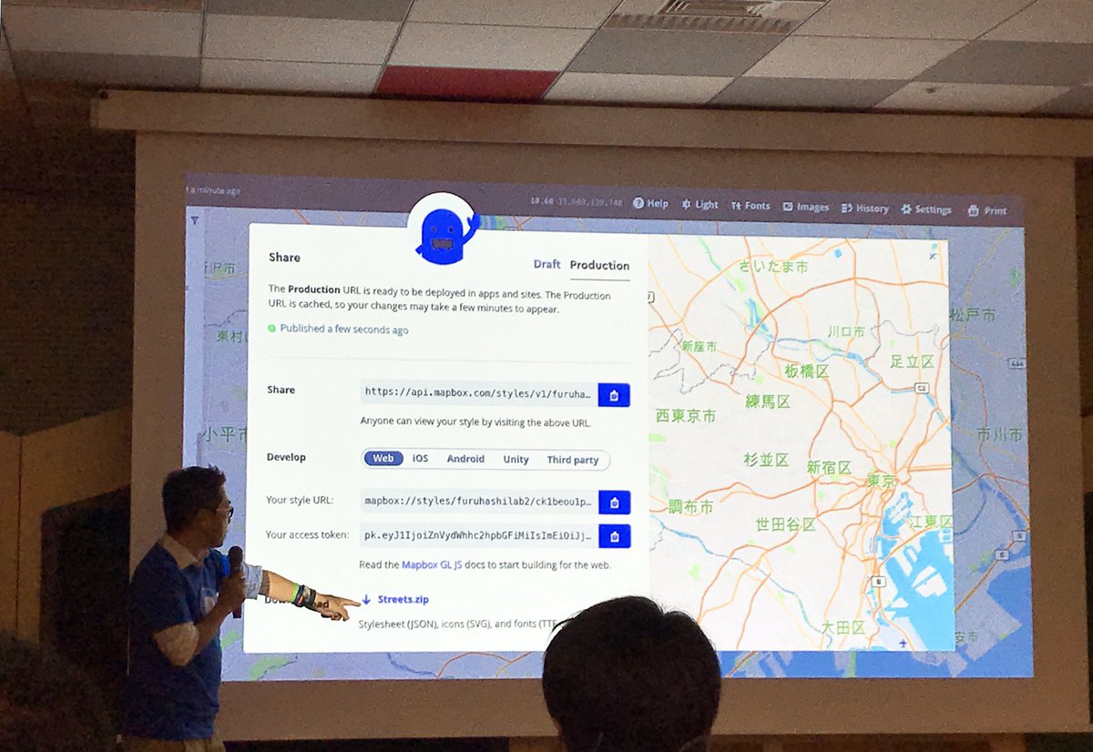
Mapbox/OpenStreetMap meet JP & hands-on#01 に参加させて頂きました! ✏️ 🗺 次回はPix4D日本オフィスとして、新製品 #Pix4Dreact について発表させて頂きます! 11月6日、WeWork日比谷にてお会いしましょう🤗 @mapbox_jp @mapconcierge #mapboxjpmeetup


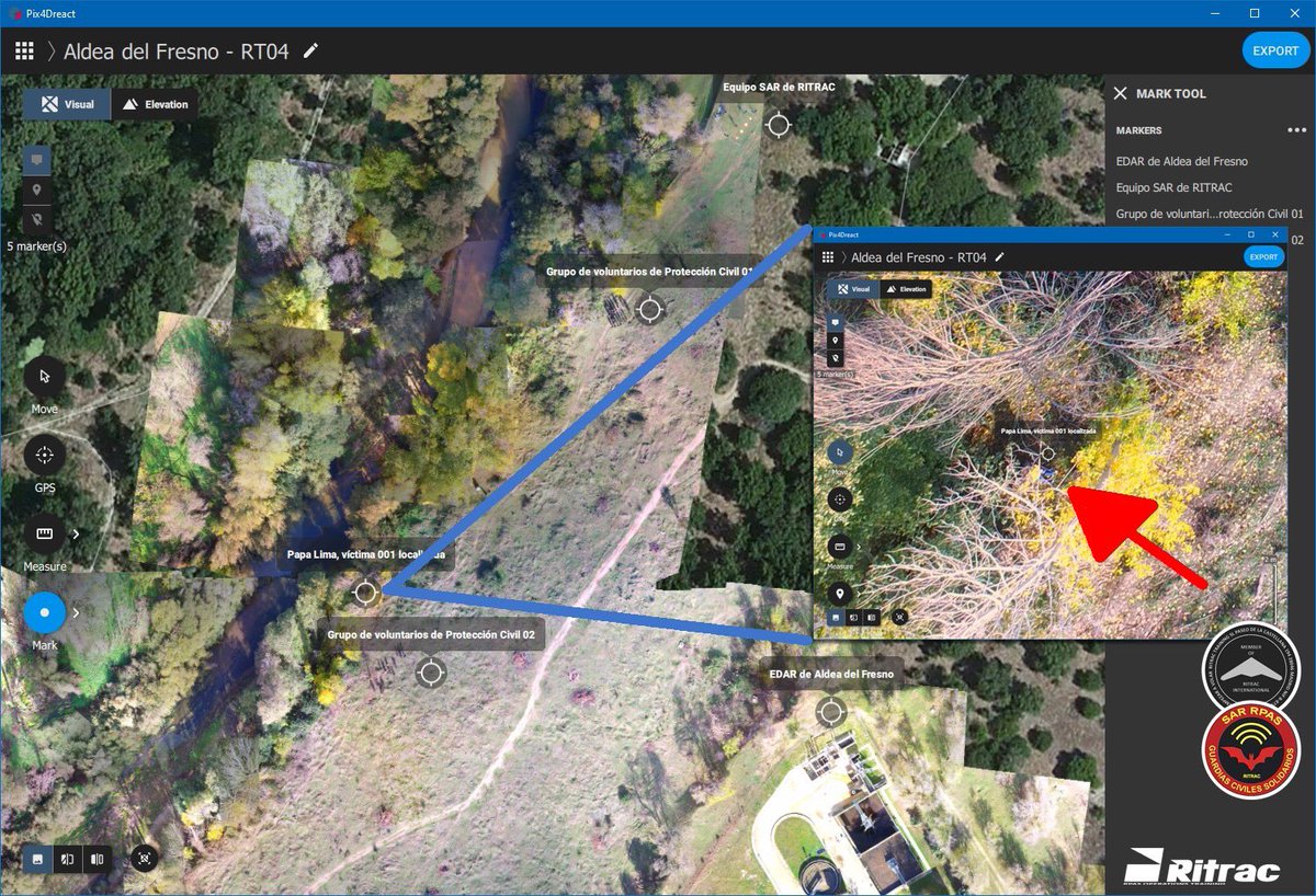
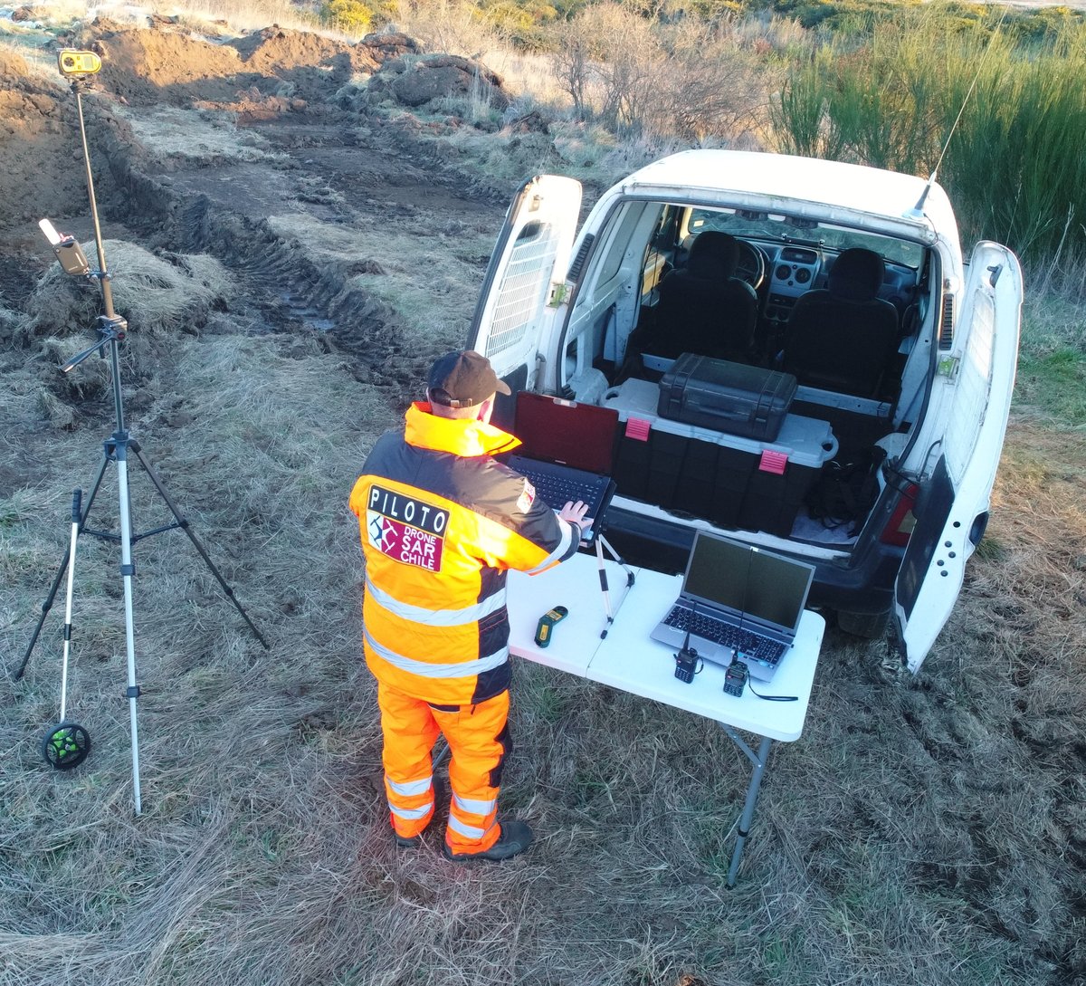
Simulacro de riada de 1979 en Aldea del Fresno del pasado sábado 23 de noviembre de 2019. Procesamos el material obtenido con nuestros #RPAS y procedemos a localizar a las victimas en el lugar de la #emergencia. Ejemplo utilizando software de procesado de imágenes #Pix4DREACT

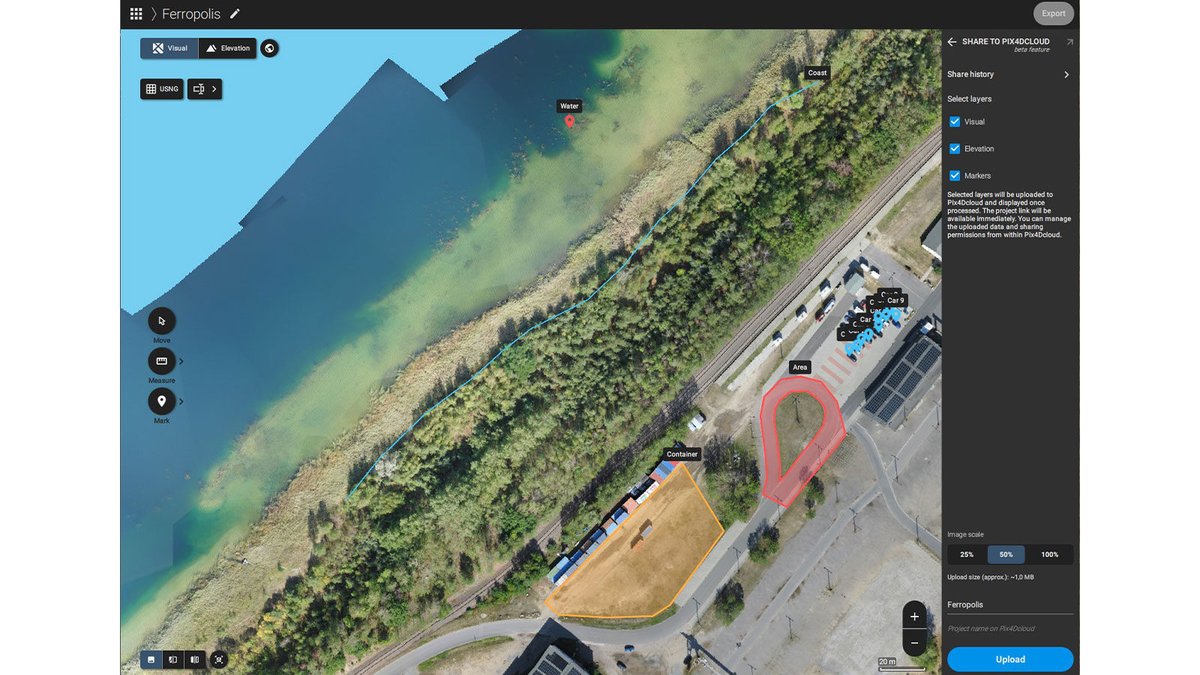
With #PIX4Dreact 1.4, you can use the share-to-PIX4Dcloud feature to easily share your results and outputs in situations where every second counts, even if your colleagues don’t use Pix4D. Download it now to get the most out of your outputs. hubs.li/H0_0Qn60 #pix4d
スタンドアロン高速2Dマッピングソフトウェア、#Pix4Dreact について、もうお聞きしましたか? 🚨 ✔️ 高速処理 ✔️ 簡単な操作 ✔️ PC高スペックは不要 ✔️ 処理にインターネット接続は不要 1ヵ月無料トライアルはこちらから➡️ ow.ly/N1AF50x3c3y

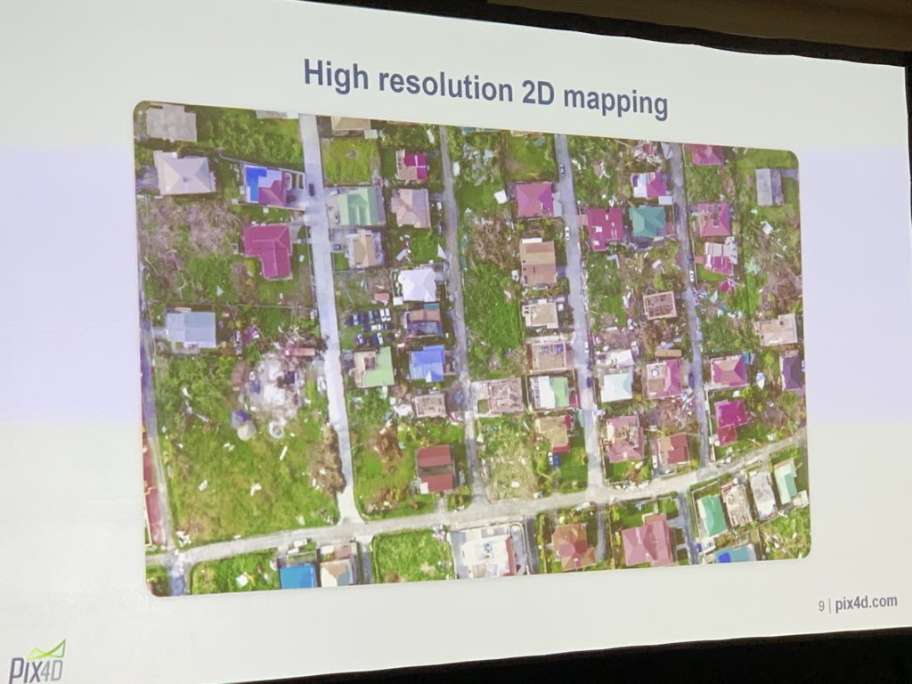
Here we go! Pix4Dreact. High speed, high resolution 2D mapping for first responders by @pix4d #djiairworks #pix4dreact.


Angad Singh @pix4d shares #pix4dReact for use in emergency response, public safety #ucpix4d for fastest imagery processing available at incidents using low cost computers. Drone use to provide access to a shooter in minutes. Or map event for emergency responders. #dronesforgood

And it's official #Pix4Dreact is available for pre-orders. So exciting to see it added to the Pix4D family of offerings. #SundanceMediaGroup is proud to be a small part of its evolution!

How can you customize your PDF report in #Pix4Dreact 1.3? Add your logo and details like address or email in settings with the customize your logo option. It will automatically appear in your PDF reports every time they are exported. Try for free: hubs.li/H0LPQNf0

Estamos felices por el lanzamiento de #Pix4Dreact software de mapeo rápido en respuesta a emergencias y ayuda humanitaria, @DroneSARChile apoyando a @pix4d en la pruebas del software, si quieres más información no dudes en contactarnos !! #DroneSARWorld #DronesHumanitarios

Large areas. 🌎 Fast mapping. ⚡️ Better decision making. 💡 Discover how the #eBeeX and #Pix4Dreact work together to help emergency responders create strategic action plans in the wake of disasters. bit.ly/2P96X1k

Discover #PIX4Dreact, the #emergencyresponse fast mapping software, and the viDoc RTK Rover, the terrestrial scanner, with Aerialsolutions at @Infopol_Xpo112 on May 10 - 12! Meeting point: Booth 3128!

Unboxing this cool bird! @AutelRobotics #EVO2 #Pro rugged bundle! It is just AMAZING! It came with a @pix4d #Pix4DReact 1 year free license to start creating #2DMaps and #orthomosaics right away with the great #Pix4D technology. Very useful tool for #LawEnforcement
#Pix4Dreact 1.2 がリリース! 最新バージョンで新しく改善された機能をお楽しみください: ✅ macOSで利用可能 ( 🍏 10.15 以上) ✅ 追加言語: 中国語とポルトガル語(日本語は対応済) ✅ Skydio 2 カメラをサポート ✅ マーカーの色選択 (点、線、面) ⬇️ ダウンロード ⬇️…

Students use #PIX4Dreact to learn #photogrammetry, processing drone images to create maps, identifying spaces & buildings for situational awareness. Advantages: ➡️ Immediate area assessment ➡️ Enhanced coordination ➡️ Offline processing Read more here: hubs.li/Q02DpvKv0
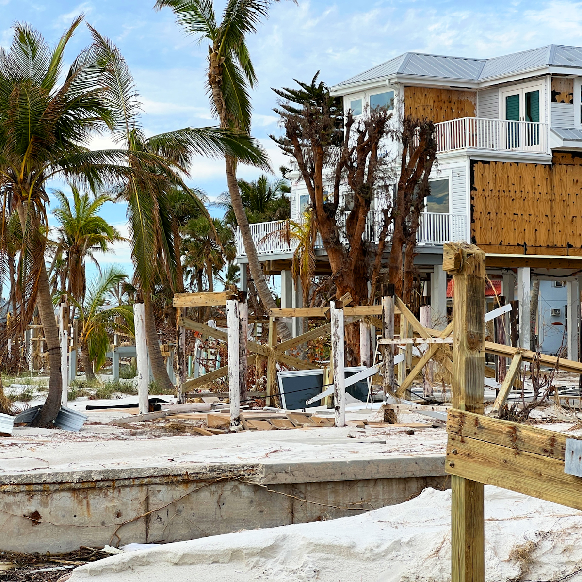
Drones played a vital role in damage assessment after Hurricane Ian. #PIX4Dreact was used to create high-resolution 2D maps, enabling a detailed analysis of the damage. The aerial maps created were used to advise for better preparedness in the future: hubs.li/Q025fY-y0

And #Pix4D has the audience engaged with #Pix4Dreact & #Pix4Dmapper. What a game changer in the field & a mapper template for #NightMapping. Thank you Angad for showing it off!

Yesterday, we posted how happy we are with @pix4d being a #UTAC2020 sponsor! Pix4D will be hosting the #drone mapping class and showcasing their new software #Pix4Dreact—a rapid-mapping tool proving useful for emergency response operations—to @UTACglobal attendees. #FLYMOTION
This article features a hands-on project where university students used drones and #PIX4Dreact to map their campus grounds, identifying new building locations and planning recreational areas: pix4d.com/blog/drones-fo… #dronesforgood #PIX4Dreact #Pix4D

🚨 #PIX4Dreact is built for #emergencyresponse teams needing speed and accuracy. Gain detailed insights by classifying objects of the same class like cars or damaged areas with a single annotation! Try PIX4Dreact for free hubs.li/Q02WCB-00
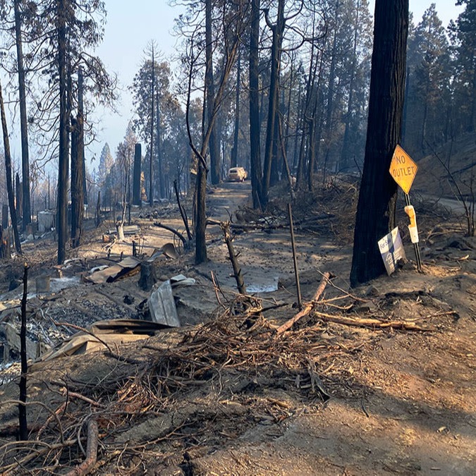
As wildfires cause widespread devastation, having accurate, up-to-date information is essential for saving lives. With #PIX4Dreact, responders can create maps from aerial imagery in minutes. Learn how to use PIX4Dreact for fire response: hubs.li/Q02L5J8B0
Students use #PIX4Dreact to learn #photogrammetry, processing drone images to create maps, identifying spaces & buildings for situational awareness. Advantages: ➡️ Immediate area assessment ➡️ Enhanced coordination ➡️ Offline processing Read more here: hubs.li/Q02DpvKv0
🌏 Empowering the youth for positive change with #PIX4Dreact. Morocco Flying Labs and Pix4D educate students to tackle local challenges through mapping skills and #photogrammetry. Teaching future generations to use drones for good: hubs.li/Q02hHfNh0 #DronesForGood

Following the earthquake in Turkey, rescue teams effectively used drones and #PIX4Dreact to respond to the disaster. We cover ten critical ways drones can be used for emergency response in our article: hubs.li/Q02bvhtC0

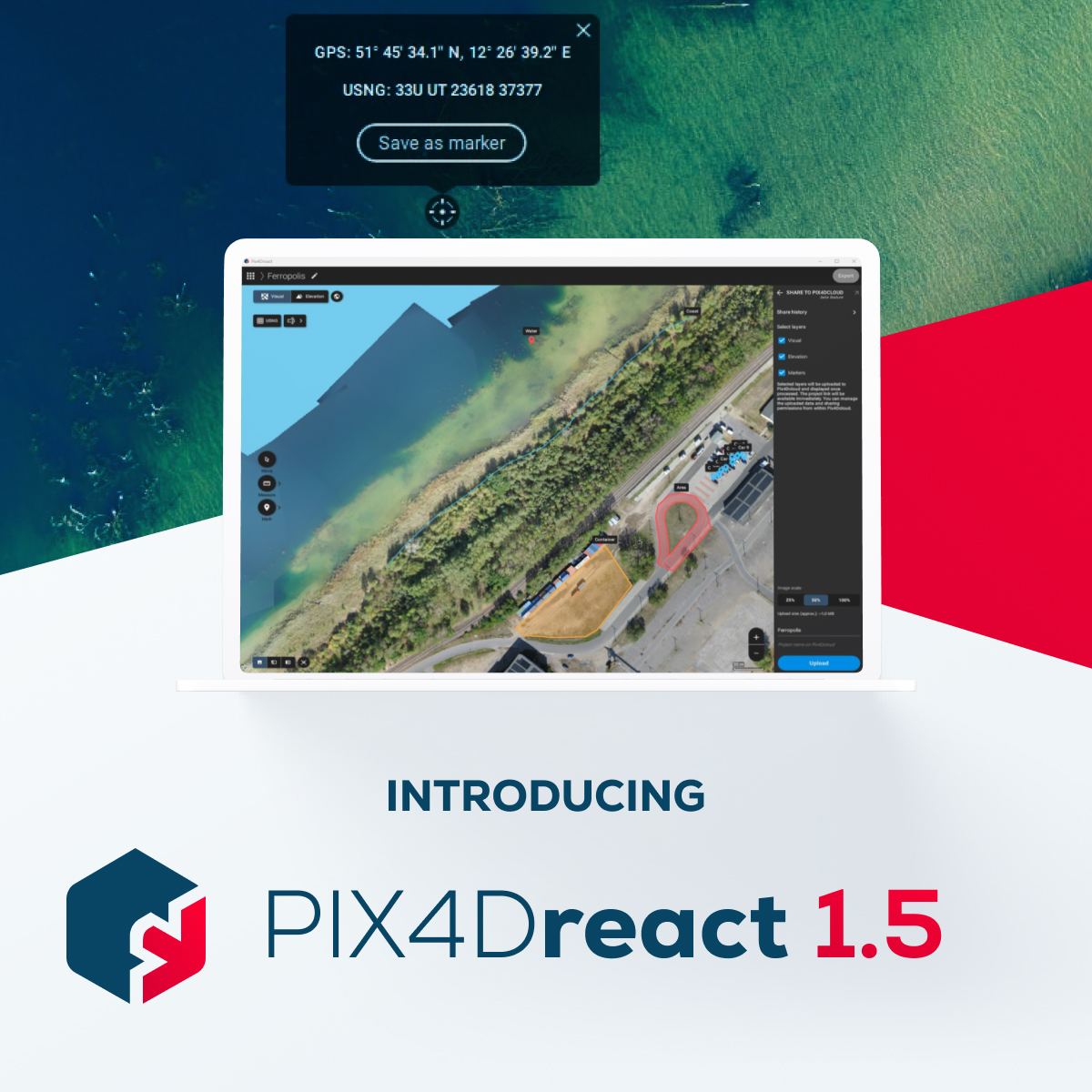
Quick and effective action relies on precise location information. #PIX4Dreact 1.5 offers the option to switch from decimal degrees to degrees, minutes, seconds. The new update offers the option to export high-resolution JPEGs for large-format printing: hubs.li/Q028GlqL0

Drones played a vital role in damage assessment after Hurricane Ian. #PIX4Dreact was used to create high-resolution 2D maps, enabling a detailed analysis of the damage. The aerial maps created were used to advise for better preparedness in the future: hubs.li/Q025fY-y0
In the aftermath of Turkey's devastating earthquakes, #PIX4Dreact swiftly provided critical data for rescue teams. Learn how #aerialmapping and #drones can make a difference in emergencies: hubs.li/Q021qZcj0 #DronesForGood

#PIX4Dreact 1.5 is here!🚨 Get high-resolution snapshots for large-format printing, support for uploading markers to PIX4Dcloud, and new location display in degrees, minutes, and seconds to further facilitate the valuable work of search and rescue teams! hubs.li/Q021613F0
Fighting fire with #drones! Learn how a career #firefighter is using #PIX4Dreact for pre-planning situational awareness and #emergency response. Check out the interview here: hubs.li/Q01-3ptL0 #PublicSafety

When #HurricaneIan swept along the coast of Florida in 2022, it caused a huge amount of damage. A specialized research team has been assessing the impact with #drones and #PIX4Dreact. This is their story: hubs.li/Q01Q95pq0
Here’s a look at at the classroom section of the #pix4dreact workshop presented by @pix4d and @Parrot!
Wildfire season is here. To keep people safe, emergency resopnders must evacuate, extinguish, and assess damage. This is how a Californian fire team maps #wildfires with #drones and checks it is safe for residents to return with #PIX4Dreact: hubs.li/Q01h63MP0 #dronesforgood
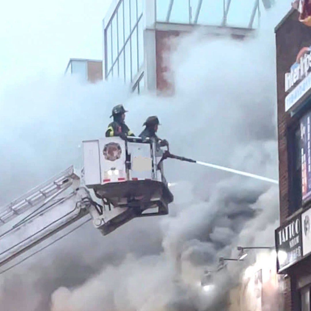
A fast response is critical for #publicsafety operations - getting situational awareness is key to effectively deploying resources. See how #PIX4Dreact was used to respond to and investigate a #fire in France: hubs.li/Q01c_bPZ0

Discover #PIX4Dreact, the #emergencyresponse fast mapping software, and the viDoc RTK Rover, the terrestrial scanner, with Aerialsolutions at @Infopol_Xpo112 on May 10 - 12! Meeting point: Booth 3128!
So far #Pix4Dreact from @pix4d is the #fastest 2D #processing soft we have used, thanks to @gab_rug for the intro. It's super #fast, works #offline with #exporting #annotation & #reporting capabilities. In less than an #hour, we #processed over 1600 #images of our project site.
Mapbox/OpenStreetMap meet JP & hands-on#01 に参加させて頂きました! ✏️ 🗺 次回はPix4D日本オフィスとして、新製品 #Pix4Dreact について発表させて頂きます! 11月6日、WeWork日比谷にてお会いしましょう🤗 @mapbox_jp @mapconcierge #mapboxjpmeetup
Here’s a look at at the classroom section of the #pix4dreact workshop presented by @pix4d and @Parrot!
Yesterday, we posted how happy we are with @pix4d being a #UTAC2020 sponsor! Pix4D will be hosting the #drone mapping class and showcasing their new software #Pix4Dreact—a rapid-mapping tool proving useful for emergency response operations—to @UTACglobal attendees. #FLYMOTION
Fast-mapping fixed-wing #drone meets fast-mapping #photogrammetry software. Learn how #Pix4Dreact and the #eBeeX provide emergency responders with essential mapping data, quickly and reliably. bit.ly/2P96X1k

Check out how @droneresponders used Drones and Pix4Dreact to map the aftermath of hurricane Dorian and much more. Via @ExpoUAV news. #dronesforgood #pix4dreact ow.ly/6geG50y0MPj

Our friends at @pix4d have released a new #drone mapping #software solution designed with emergency responders in mind. #Pix4Dreact quickly creates 2D maps to help decide the necessary moves to save lives in disastrous conditions. Learn more here: bit.ly/2BAx0YV
Large areas. 🌎 Fast mapping. ⚡️ Better decision making. 💡 Discover how the #eBeeX and #Pix4Dreact work together to help emergency responders create strategic action plans in the wake of disasters. bit.ly/2P96X1k

All is ready!! Mañana empieza el European Robotic Forum. #erf2020 Ven a conocer las aplicaciones de nuestros rpas para trabajar en SAR, el software #Pix4Dreact, y los sistemas GNSS RTK #ReachM2 para navegación y guiado de vehículos @eu_Robotics @pix4d @emlid @Fycma @PTAMalaga


Simulacro de riada de 1979 en Aldea del Fresno del pasado sábado 23 de noviembre de 2019. Procesamos el material obtenido con nuestros #RPAS y procedemos a localizar a las victimas en el lugar de la #emergencia. Ejemplo utilizando software de procesado de imágenes #Pix4DREACT
[ブログ] 9月にバハマに上陸したハリケーン「ドリアン」の被害状況の把握と復興計画のために、カナダのNGO、GlobalMedicが #Pix4Dreact を使用しました。インターネット接続が無い状況でもドローン画像からの高速マッピングが可能です。 #災害対応 #dronesforgood 👉ow.ly/N7EM50wTsU2
![pix4d_japan's tweet image. [ブログ] 9月にバハマに上陸したハリケーン「ドリアン」の被害状況の把握と復興計画のために、カナダのNGO、GlobalMedicが #Pix4Dreact を使用しました。インターネット接続が無い状況でもドローン画像からの高速マッピングが可能です。
#災害対応 #dronesforgood
👉ow.ly/N7EM50wTsU2](https://pbs.twimg.com/media/EHrmxldWwAsZL0e.jpg)
A week ago @Geoconnexion wrote about our Pix4Dreact launch! Have you tried it yet? ow.ly/hmsS50wX2Fm #pix4dreact #2Dfastmapping #publicsafefy #emergencyresponse
⚠️ Reminder that we are hosting a free webinar next week (Dec 10)! Learn from actual Public Safety professionals about their use of #Pix4Dreact in real world situations with tangible results. Register now! 🔗 ow.ly/o6E650xr4FR
Discover #PIX4Dreact, the #emergencyresponse fast mapping software, and the viDoc RTK Rover, the terrestrial scanner, with Aerialsolutions at @Infopol_Xpo112 on May 10 - 12! Meeting point: Booth 3128!

Its developers have designed PIX4Dreact to be intuitive and straightforward to use even in the most stressful scenariosand is tailored to the unique challenges of public safety and humanitarian aid professionals. Click below to learn more: hi.switchy.io/8KMc #pix4dreact

Merci à @studioSPORT_fr d'avoir fait une présentation du tout nouveau logiciel de cartographie rapide par #drone #Pix4dReact de @pix4d #IEDOFrance

Here we go! Pix4Dreact. High speed, high resolution 2D mapping for first responders by @pix4d #djiairworks #pix4dreact.
And #Pix4D has the audience engaged with #Pix4Dreact & #Pix4Dmapper. What a game changer in the field & a mapper template for #NightMapping. Thank you Angad for showing it off!
This article features a hands-on project where university students used drones and #PIX4Dreact to map their campus grounds, identifying new building locations and planning recreational areas: pix4d.com/blog/drones-fo… #dronesforgood #PIX4Dreact #Pix4D
Something went wrong.
Something went wrong.
United States Trends
- 1. Cloudflare 32.4K posts
- 2. Cowboys 74.2K posts
- 3. #heatedrivalry 30.7K posts
- 4. Happy Farmers 2,104 posts
- 5. LeBron 115K posts
- 6. Warner Bros 34.2K posts
- 7. Wizkid 182K posts
- 8. Pickens 15.3K posts
- 9. Lions 93.8K posts
- 10. fnaf 2 28.1K posts
- 11. rUSD N/A
- 12. Jake Tapper 44.8K posts
- 13. Shang Tsung 36.5K posts
- 14. Paramount 22.2K posts
- 15. Gibbs 21.2K posts
- 16. #PowerForce N/A
- 17. scott hunter 6,997 posts
- 18. Davido 101K posts
- 19. Hiroyuki Tagawa 32.3K posts
- 20. The Gong Show N/A