#quickmap wyniki wyszukiwania

Know before you go 🚙🌨️🧊☠️🏔️ Be sure to check @CaltransDist3 #QuickMap and @CHP_Truckee for chain controls & CHP incidents affecting your drive to the high Sierra Lake Tahoe CAwx @NWSSacramento @TahoeWeather

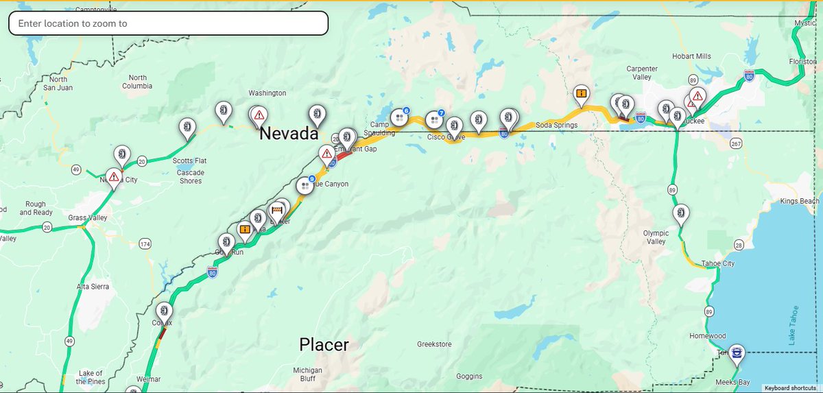
Winter is back in the Sierra! Chain controls on I-80 between Nyack-Truckee EB and Donner Lake Interchange - Nyack WB! Snow is expected all day. Be prepared and carry chains if you go! Chain controls active on SR 20 Washington Road-I-80 interchange quickmap.dot.ca.gov
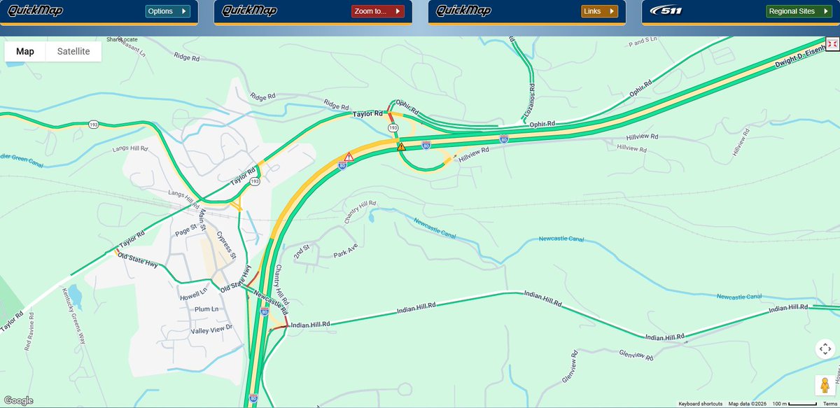
Update: #2 and #3 lanes blocked and WB I-80 on-ramp from SR 193 is closed. Still no ETO. Check #QuickMap or download the app for any updates.
#TrafficAlert Slow lane blocked, westbound I-80 near the junction with State Route 193 in Newcastle due to traffic collision. No ETO. Motorists are advised to use caution and expect delays.

Take one more precaution and download our #Quickmap app (free for your smartphone) for real time updates on chain controls, road closures and more. We like to say that it’s better to #KnowBeforeYouGo.

Winter is still on full force 3rd week in April: wacky winter 🌨️, no?! Cold 🥶 & high Sierra Nevada 🏔️ snow dump currently until tomorrow night Know before you go by checking @CaltransDist3 #QuickMap @CHP_Truckee @NWSSacramento @NWSReno CAwx NVwx #CalTrans 👇
Winter is back in the Sierra! Chain controls on I-80 between Nyack-Truckee EB and Donner Lake Interchange - Nyack WB! Snow is expected all day. Be prepared and carry chains if you go! Chain controls active on SR 20 Washington Road-I-80 interchange quickmap.dot.ca.gov
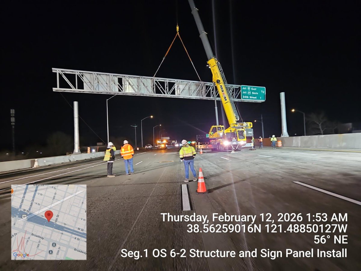
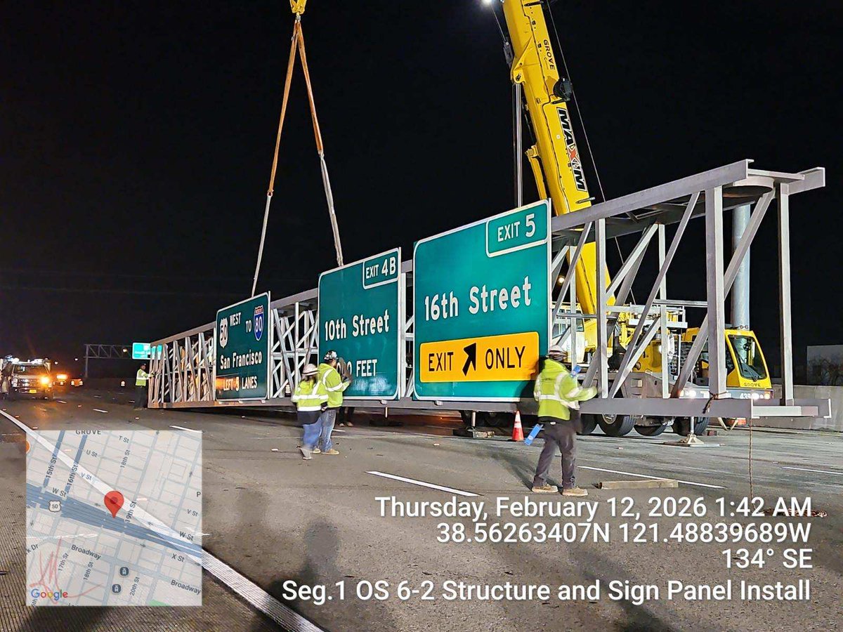
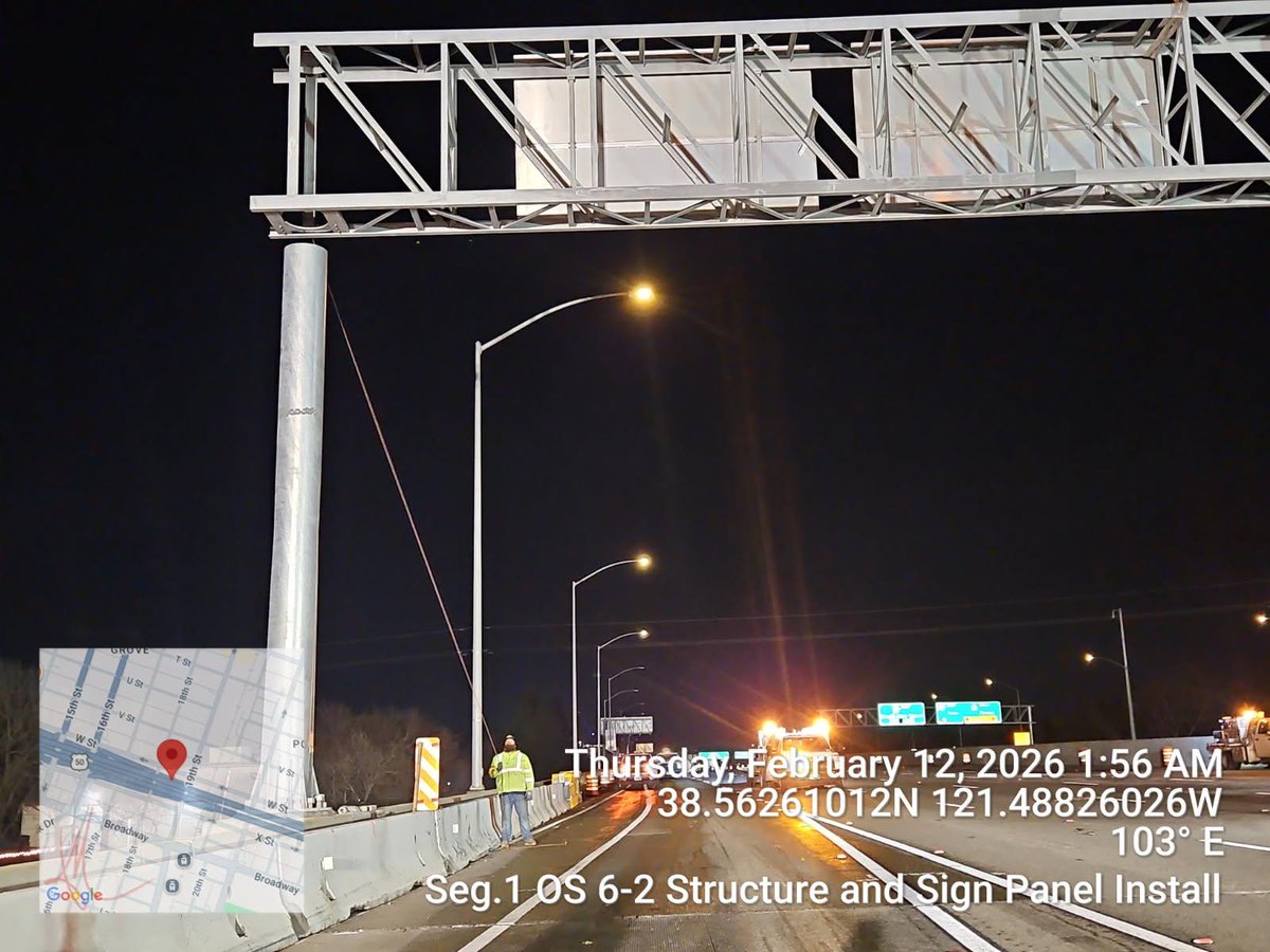
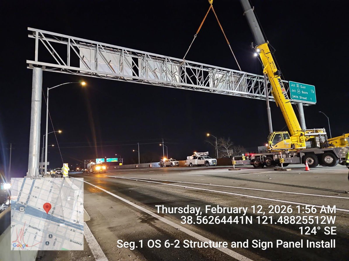
#Update The overhead sign installation that took place last night across westbound of the FIX50 project in Sacramento, was completed successfully by our crews and they were able to open the traffic break ahead of schedule. #KnowBeforeYouGo #QuickMap
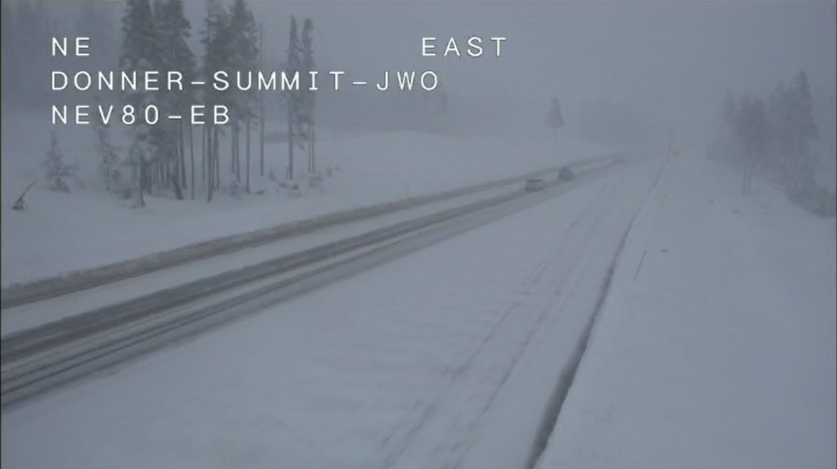
Here’s what Tahoe roads look like last night driving over Donner Summit Know before you go by checking @CaltransDist3 #QuickMap for chain controls, CHP incidents affecting your drive to/from the high Sierra Nevada Lake Tahoe, Reno Nevada CAwx NVwx
🚙🌨️❄️🏔️ Last night snow dump POV iPhone video driving over Donner Summit Kudos to @CaltransDist3 🙏 for an excellent job keeping Lake Tahoe roads snowplowed #CAwx @TahoeWeather @NWSSacramento @NWSReno @jason61987 @realwxforecast @alpinemike13 @Weather_West @RobMayeda
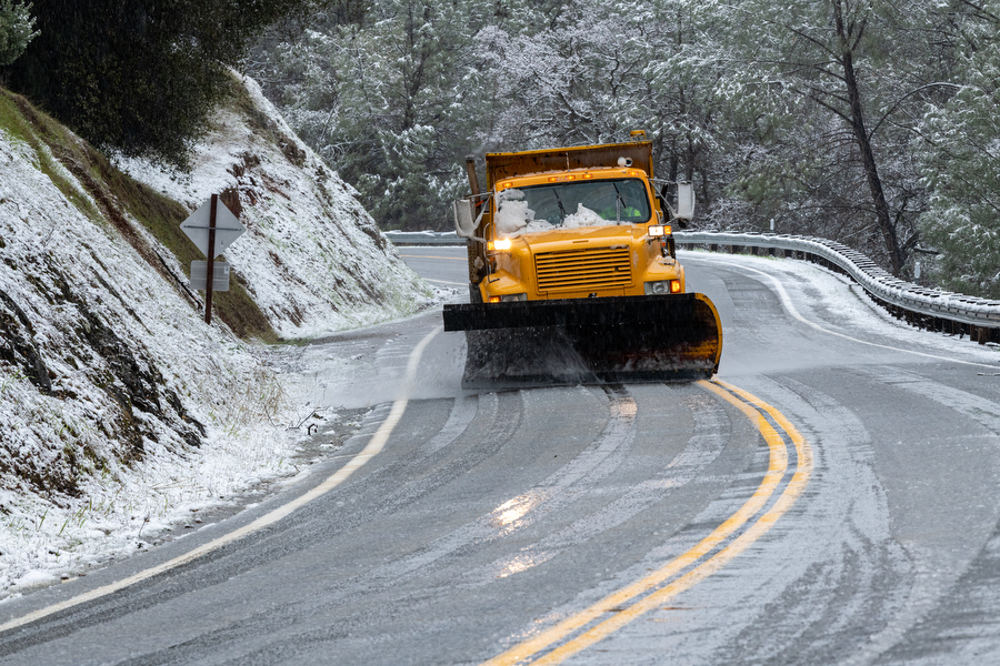
Snow earlier this week = appetizer. Snow next week = MAIN COURSE. Check the forecast and monitor #QuickMap for real-time roadway information. More details here, conta.cc/4rOw2iP @CHPGoldRun @CHP_Truckee @chp_donnerpass @CHPgv @CHPSouthLake @CHPPlacerville @CHP_Quincy

Lane blocked along westbound U.S. 50 near Echo Summit due to vehicle recovery and clean up after a truck hauling hay overturned. No ETO. Check #QuickMap for any updates.


With bad weather, road conditions can change quickly. Pay attention to warnings! If you need to travel, slow down, budget more time - and #KnowBeforeYouGo. Download @CaltransHQ #Quickmap at quickmap.dot.ca.gov to get up-to-date traffic information.
Winter Storm Update from NWS. #KnowBeforeYouGo and be prepared for delays and chain controls in the Sierra Nevada. Check #QuickMap at quickmap.dot.ca.gov or download the app for any updates.
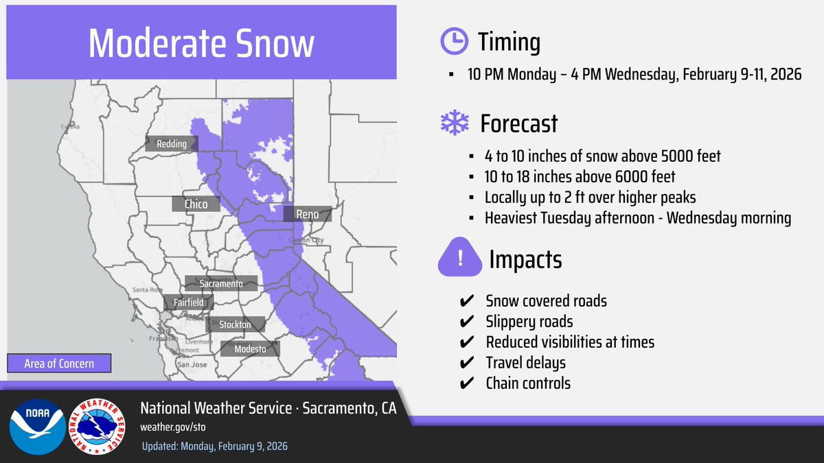
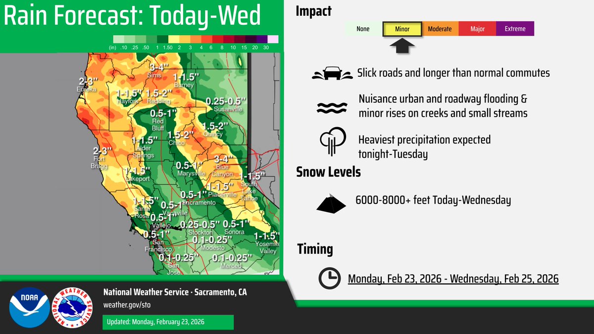
A weather system will bring widespread showers, moderate mountain snow above 5000 feet, and isolated thunderstorms late tonight into Wednesday. Best precipitation chances expected later Tuesday into Wednesday. Slow down & check road conditions before you go! #CAwx
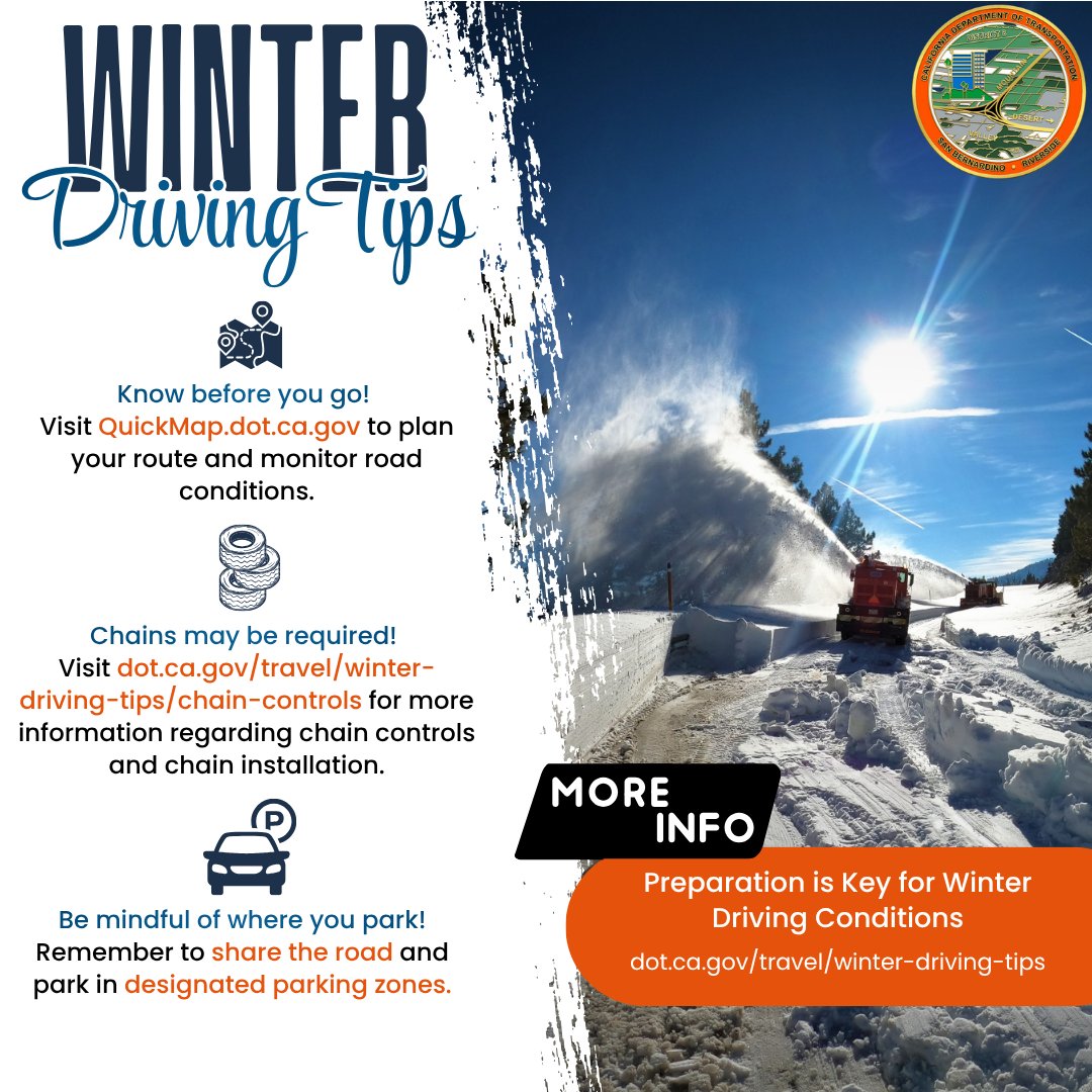
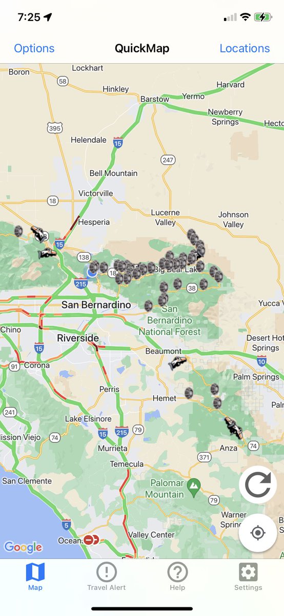
Winter storms are here, plan your travels accordingly. Check Quickmap.dot.ca.gov, visit dot.ca.gov/travel/winter-…, and check signage in the area to ensure you are parked in appropriate parking zones. #Caltrans8 #QuickMap #chaincontrol #SBCounty #RiversideCounty
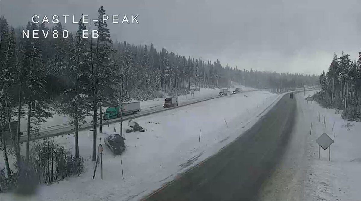
Chains controls are still up along I-80 this morning. Take it slow and check #QuickMap for any updates. As of 7:45 a.m. EB (R2) Kingvale to Truckee, WB Donner Lake Interchange to Rainbow. Trucks: Turning all single pulling doubles at Applegate and DLI.
Check #QuickMap for any updates.

TRAFFIC ADVISORY: I-5 SB to SR-113 North The off-ramp from I-5 southbound to SR-113 north is closed due to a commercial vehicle spilling a load of rice. Crews are on scene working to clear the roadway. Unknown ETO. 03/17/2026 @ 1:53 p.m.
Mostly rain expected with this storm. Stay prepared and check #QuickMap or download the app for real-time roadway information.
#TrafficAlert Traffic is being held along westbound I-80 near Whitmore. There is no estimate of when traffic will be released. Delays are expected. Check #QuickMap for any updates. @CHPGoldRun

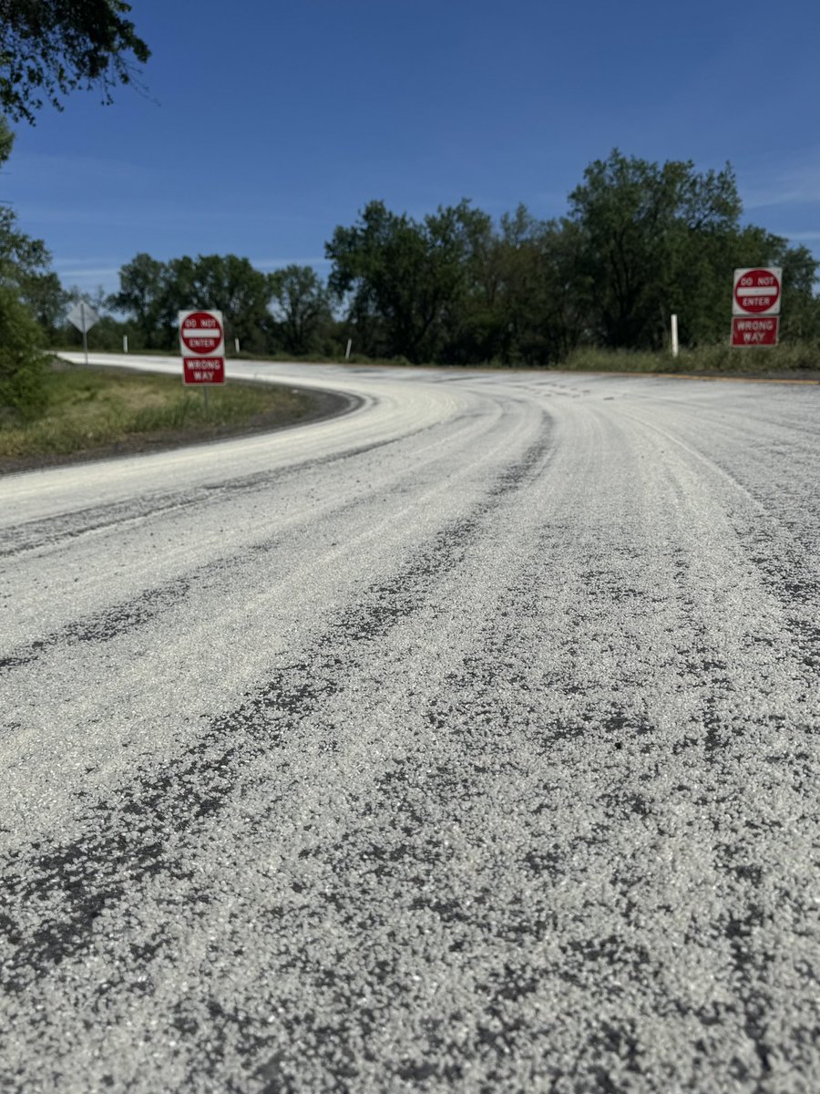
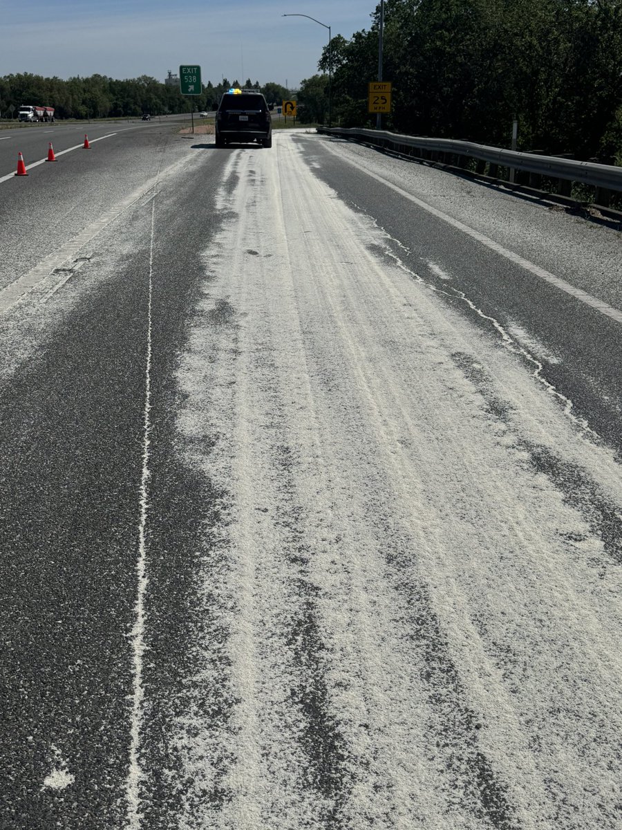
#TrafficAlert Eastbound SR-4 is closed at Mill Creek in #CalaverasCounty due to heavy snow. No ETO. For the latest on road closures and highway conditions, visit quickmap.dot.ca.gov or download the #Quickmap app on your mobile device.

People will notice snow in areas where it’s not normally at. This storm is a big one, stay off the roads if able. #Quickmap will inform you of road conditions. Even the Cajon Pass has some snow right now. Slow down and leave room if you travel. #Caltrans8


Here’s what Tahoe roads look like last night driving over Donner Summit Know before you go by checking @CaltransDist3 #QuickMap for chain controls, CHP incidents affecting your drive to/from the high Sierra Nevada Lake Tahoe, Reno Nevada CAwx NVwx
🚙🌨️❄️🏔️ Last night snow dump POV iPhone video driving over Donner Summit Kudos to @CaltransDist3 🙏 for an excellent job keeping Lake Tahoe roads snowplowed #CAwx @TahoeWeather @NWSSacramento @NWSReno @jason61987 @realwxforecast @alpinemike13 @Weather_West @RobMayeda
Know before you go 🚙🌨️🧊☠️🏔️ Be sure to check @CaltransDist3 #QuickMap and @CHP_Truckee for chain controls & CHP incidents affecting your drive to the high Sierra Lake Tahoe CAwx @NWSSacramento @TahoeWeather
Winter is back in the Sierra! Chain controls on I-80 between Nyack-Truckee EB and Donner Lake Interchange - Nyack WB! Snow is expected all day. Be prepared and carry chains if you go! Chain controls active on SR 20 Washington Road-I-80 interchange quickmap.dot.ca.gov
Winter is still on full force 3rd week in April: wacky winter 🌨️, no?! Cold 🥶 & high Sierra Nevada 🏔️ snow dump currently until tomorrow night Know before you go by checking @CaltransDist3 #QuickMap @CHP_Truckee @NWSSacramento @NWSReno CAwx NVwx #CalTrans 👇
Winter is back in the Sierra! Chain controls on I-80 between Nyack-Truckee EB and Donner Lake Interchange - Nyack WB! Snow is expected all day. Be prepared and carry chains if you go! Chain controls active on SR 20 Washington Road-I-80 interchange quickmap.dot.ca.gov

@CaltransHQ -- The new #QuickMap layout looks great! Too bad not one single live camera works!
Well, hello high Sierra Nevada 🏔️#LakeTahoe winter 🌨️❄️ @NWSSacramento @NWSReno & hello cold front from Alaska @jason61987 @TahoeWeather @RobMayeda Time to PLAY #SF🏂⛷️❄️❄️ Be sure to check @CaltransDist3 #QuickMap @CHP_Truckee before & enroute to/from 🏔️@renotahoe #CAwx


#construction #reminder the 15-hour closure to the northbound SR 99 to eastbound US 50 connector starts tonight at 10 p.m. Check #quickmap for real-time road conditions and closures.
#TrafficAlert Thanks to mother nature being cooperative, the next 15-hour closure at the NB SR 99 to EB US 50 connector for pavement work as part of the “Fix50” Project, is scheduled from 10 p.m. April 17, to 1 p.m. April 18. conta.cc/4tUW7ho ##KnowBeforeYouGo #TellAFriend

#TrafficUpdate: SR-140 #MariposaCounty remains closed from Bear Creek Bridge to Cedar Lodge due to rock slide removal and safety Assessment. Motorists should seek alternate route and check #Quickmap for closure info. in real-time.
#TrafficUpdate #MariposaCounty SR-140 will remain closed overnight from Bear Creek Bridge to Cedar Lodge for continued rock slide removal. No ETO at this time. Motorists should seek alternate route. For continued traffic and closure information in real-time, always use #QuickMap

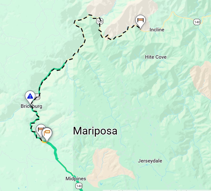
#TrafficUpdate #MariposaCounty SR-140 will remain closed overnight from Bear Creek Bridge to Cedar Lodge for continued rock slide removal. No ETO at this time. Motorists should seek alternate route. For continued traffic and closure information in real-time, always use #QuickMap
#TrafficAlert #MariposaCounty A rock slide has occurred for a 2nd time today on SR-140, just west of El Portal. Roadway is blocked in both directions. No ETO at this time. Motorists should seek alternate route. #Quickmap

Be sure to check before and during your drive to Tahoe for current high #Sierra Nevada #LakeTahoe road conditions, chain controls, CHP incidents affecting your drive 👇 ✅ #QuickMap, bookmark quickmap.dot.ca.gov Enter freeway # 80 88 50 89 👇 roads.dot.ca.gov/roadscell.php
Here’s what it looks like from a ‘burst of heavy & accumulating Sierra snowfall’ at Palisades Tahoe today from a @snowpalstahoe’s member who is a storm chaser Winter returns to Lake Tahoe for #MiracleApril #CAwx @UCB_CSSL UC Berkeley Central #Sierra Snow Lab
Broken record is on repeat mode KNOW BEFORE YOU GO to #Sierra mountains 🏔️ Lake Tahoe CHP Truckee & #CalTrans been busy: ‘Multiple crashes, vehicles spun off roadway’ ✅ #QuickMap ✅ SLOW DOWN ✅ increase following distance ✅ DOWNSHIFT to low gears 🚙🌨️⚙️🏔️ 📷 @CHP_Truckee
Remember to plan ahead for winter driving. Pack chains, snacks, water, emergency supplies and expect delays. The commute will take you longer, especially under chain control. Check #QuickMap for updates.

#PlanAhead To view traffic advisories for this week's construction and maintenance projects, visit: dot.ca.gov/caltrans-near-…. #KnowBeforeYouGo with traffic and road closure info in real-time using quickmap.dot.ca.gov — or download the #Quickmap app on your mobile device.

Thanks @realwxforecast CAwx If planning to ski 🏂⛷️ Saturday & Sunday during the storm, best to check the hourly forecast to get to your high Sierra Lake Tahoe destination b4 the high wind gusts, heavy snow & thunderstorms hit ✅ @CaltransDist3’s #QuickMap 🚙☠️🌨️🧊🌬️🏔️
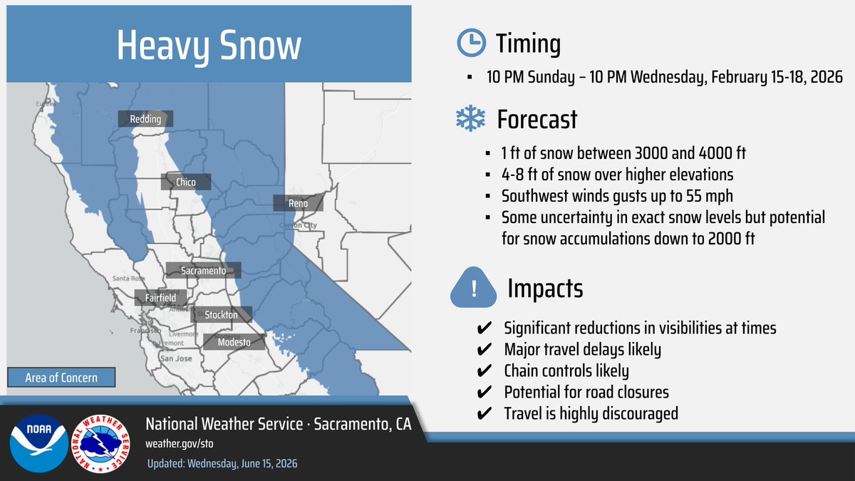
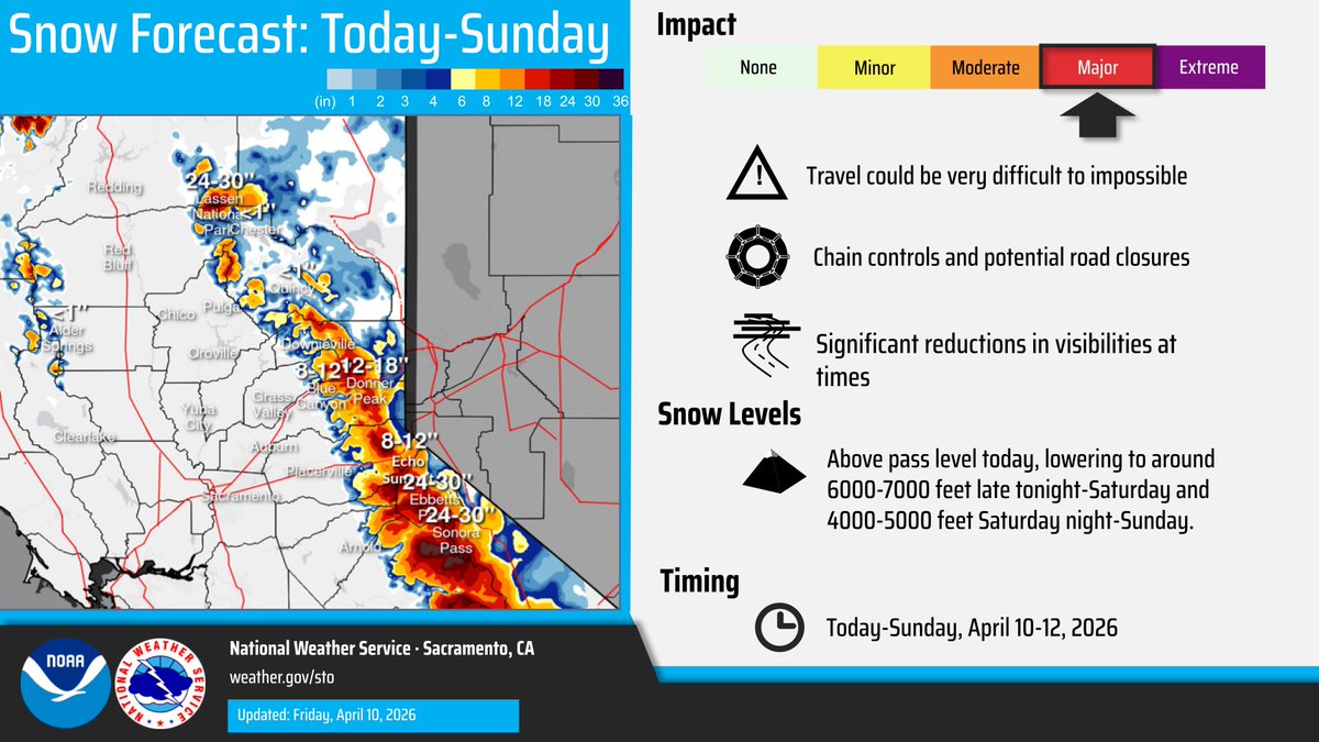
Sierra Nevada 🏔️NWS Winter Travel Advisory Heavy snow 6 to 10 inches for #LakeTahoe to 7k feet, 12 to 28 inches above 7k feet & for #Sierra passes Winds gust 90 mph over ridges 20-35 mph low elevation From 2 PM Saturday April 11 to 11 PM Sunday Thunderstorms = ⚠️🛑🚠🚡 #CAwx


Guess it’s going to be one of those springs. Showers, thunderstorms and even snow is in the forecast for the Sierra through this weekend. #knowbeforeyougo and check #quickmap for real time road conditions.


#TrafficAlert #MercedCounty SR-165 closed from River Rd. to Turner Ave. due to an incident involving an overturned big rig. No ETO. Motorists should avoid this route. For traffic and closure information in real-time use Quickmap.dot.ca.gov. #QuickMap

Chains controls are still up along I-80 this morning. Take it slow and check #QuickMap for any updates. As of 7:45 a.m. EB (R2) Kingvale to Truckee, WB Donner Lake Interchange to Rainbow. Trucks: Turning all single pulling doubles at Applegate and DLI.
Chain controls up on I-80 Winter🥶 wonderland revisits Check @CaltransDist3 #Caltrans #QuickMap before, during your drive to the high Sierra Nevada mountains #LakeTahoe quickmap.dot.ca.gov/mindex.html Stay safe Increase 🚙🚐 distance Downshift low gear 🏔️


#TrafficAlert Traffic is being held along westbound I-80 near Whitmore. There is no estimate of when traffic will be released. Delays are expected. Check #QuickMap for any updates. @CHPGoldRun
Winter storms are here, plan your travels accordingly. Check Quickmap.dot.ca.gov, visit dot.ca.gov/travel/winter-…, and check signage in the area to ensure you are parked in appropriate parking zones. #Caltrans8 #QuickMap #chaincontrol #SBCounty #RiversideCounty
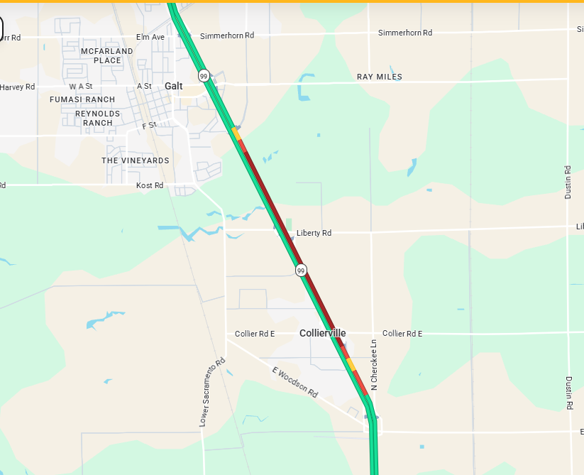
#TrafficAlert 3/16/2026 8:30 am. Due to a vehicle on fire on northbound SR 99 in the Central Galt exit area, there is significant back up on SR 99. Please use alternate routes or avoid the area. No ETO. #KnowBeforeYouGo #quickmap
Chain controls are up along I-80 in the Sierra Nevada for all vehicles expect those with 4WD/AWD and snow tires. EB Kingvale - Truckee, WB Truckee - Rainbow, minimum restrictions for trucks. Check #QuickMap for updates. @CHPGoldRun @CHP_Truckee
#TrafficAlert Right lane blocked southbound I-5 near County Road 102 in Woodland. No ETO. Expect delays as traffic is slowly moving through the area. Check #QuickMap for any updates.

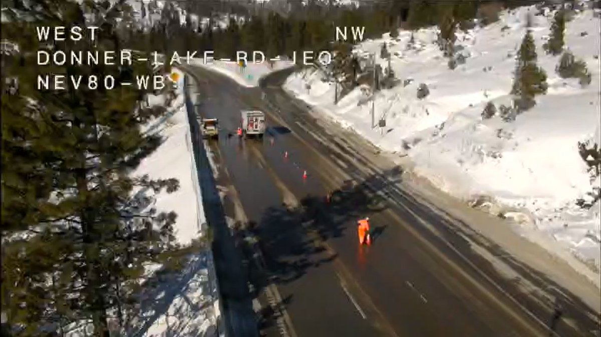
The sun is out and crews are making headway on I-80. As of 10:40 a.m. chain controls are (R2) EB Nyack to Truckee, WB Donner Lake Interchange to Rainbow, minimum restrictions for trucks. Check #QuickMap for updates. @CHP_Truckee @CHPGoldRun
#TrafficAlert Southbound State Route 70 lanes are blocked near the junction with State Route 99 due to a traffic collision. Traffic is being diverted at Striplin Road. No ETO. Check #QuickMap for any updates.

Guess it’s going to be one of those springs. Showers, thunderstorms and even snow is in the forecast for the Sierra through this weekend. #knowbeforeyougo and check #quickmap for real time road conditions.
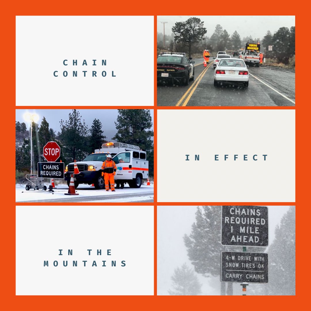
Just a reminder, bring those chains if you plan on visiting any mountain communities. We are issuing chain control again for the San Bernardino mountains, use #Quickmap to view locations. Try your best to travel when weather is good, not during inclement periods. #Caltrans8
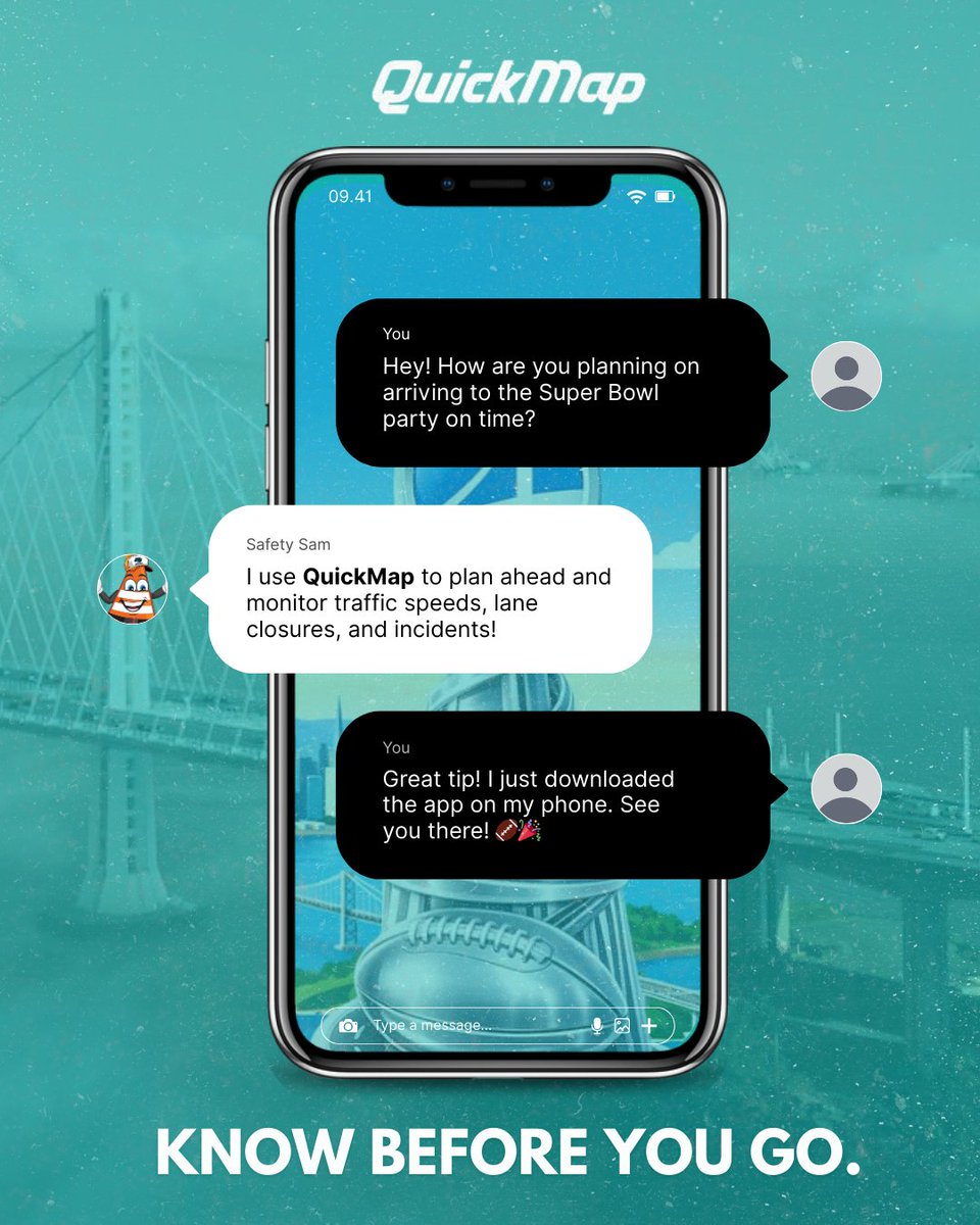
Before you hit the road this Super Bowl week 🏈📷Download the Caltrans QuickMap app for real-time traffic, closures, and incidents. Available on mobile and web: quickmap.dot.ca.gov Travel smart and stay safe! #Caltrans #QuickMap #SuperBowlWeek #BayAreaMoves
Don’t be a dummy, hunny. Get those chains ready, cause certain areas are requiring you to chain up no matter what vehicle you have. Use #Quickmap to see locations and what level. If you don’t want to put on chains, then consider a different travel day. #Caltrans8

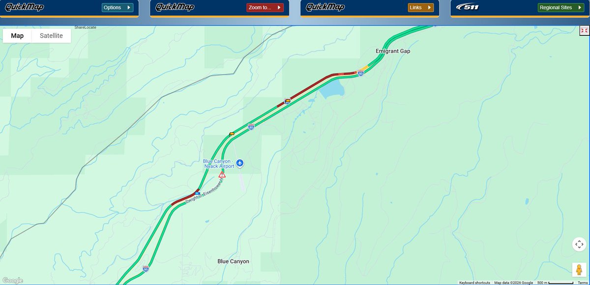
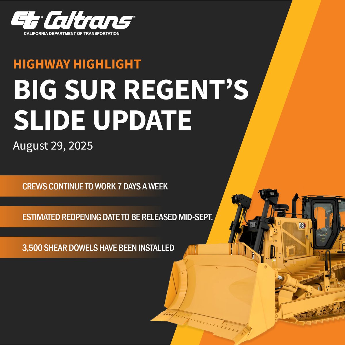
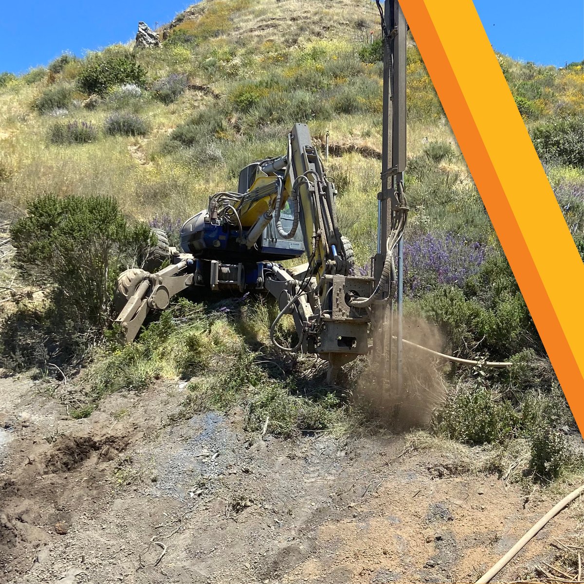
Highway Highlights: Sept. 29 Crews at Regent's Slide are working 7 days a week! -Excavation + slope stabilization continue. -Shear dowels are keeping the mountain in place. ⚠️For road updates, visit the Caltrans #Quickmap at QuickMap.dot.ca.gov or call 1-800-427-ROAD.


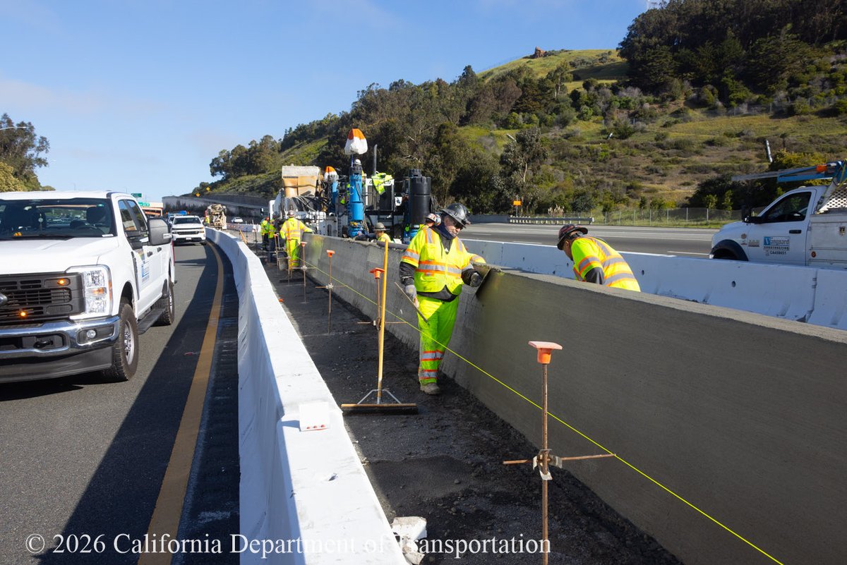
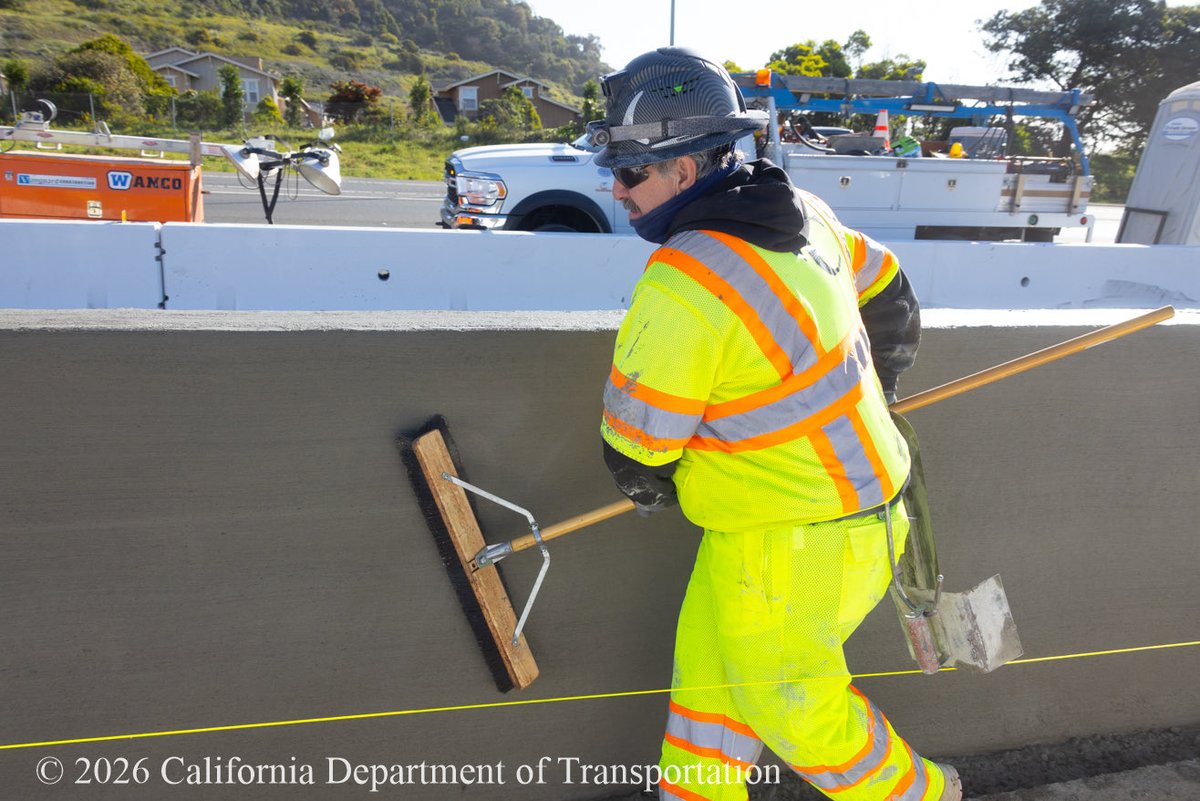
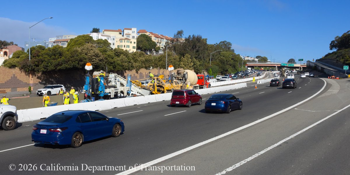
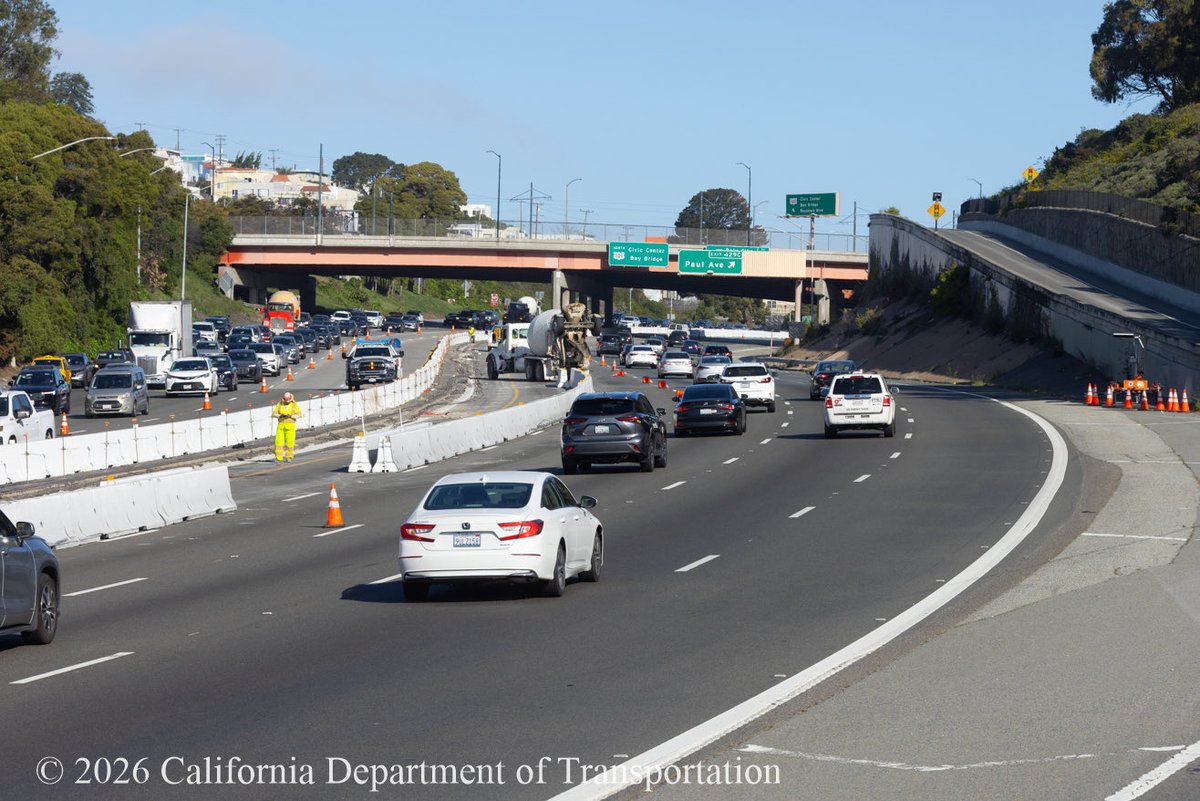
More images from the weekend project underway on the U.S. 101 Bayshore Freeway. Work will be completed by 6 a.m. Monday, until then plan early and refer to #Quickmap and download our detour to avoid delays at sfhighwayprojects.com
Chain Control is in effect in the mountains for RIVCO and SBCO. Bring your chains as some areas are R3 conditions which means all vehicles require chains. Use #Quickmap to view these locations. #Caltrans8

🚗 Ready to roll? Before you hit the road, open the #QuickMap app or visit 🔗 QuickMap.dot.ca.gov to check live updates on road closures, traffic, and chain controls. Travel smart. Travel safe. 🛣️ #KnowBeforeYouGo #CaltransD4 #SlowForTheConeZone @CaltransHQ @CHP_HQ

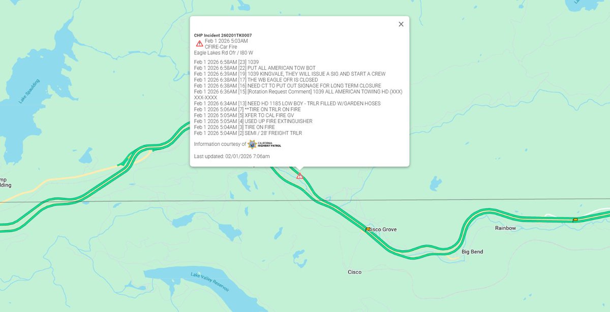
#TrafficAlert | County of Nevada, CA | 2/1/2026 at 7:12 a.m. Caltrans has closed Exit 164 on State Route 80 due to a vehicle fire. A long-term closure is expected while crews complete cleanup operations. Check #QuickMap for real time updates on closure.
SF-Bay Area Motorists! Avoid delays🚘while U.S. 101 Bayshore Freeway (Hospital Curve) weekend work and lane reductions are underway thru Monday, 7 a.m. Consider using detour. Visit sfhighwayprojects.com to learn more about #Fab4 projects. Check #Quickmap🚧

Snow earlier this week = appetizer. Snow next week = MAIN COURSE. Check the forecast and monitor #QuickMap for real-time roadway information. More details here, conta.cc/4rOw2iP @CHPGoldRun @CHP_Truckee @chp_donnerpass @CHPgv @CHPSouthLake @CHPPlacerville @CHP_Quincy
🚨Alert! San Francisco-Oakland Bay Bridge 🌉joint rehab work is underway on the lower deck. Thanks to crew for placing temp panels for smoother ride across. Don't forget! Check #QuickMap app or visit 👉 QuickMap.dot.ca.gov for real-time updates on closures and delays.

Something went wrong.
Something went wrong.
United States Trends
- 1. #EarthDay N/A
- 2. SPLC N/A
- 3. Texas N/A
- 4. Rocket Power N/A
- 5. #AllStars11 N/A
- 6. Virginia N/A
- 7. Republicans N/A
- 8. Spirit Airlines N/A
- 9. Tanner Bibee N/A
- 10. Clayface N/A
- 11. Stephen Jones N/A
- 12. Rep. David Scott N/A
- 13. I-10 by 10 N/A
- 14. Lucas Giolito N/A
- 15. CatDog N/A
- 16. Chelsea N/A
- 17. George Pickens N/A
- 18. Southern Poverty Law Center N/A
- 19. Liam Rosenior N/A
- 20. Crown Center N/A