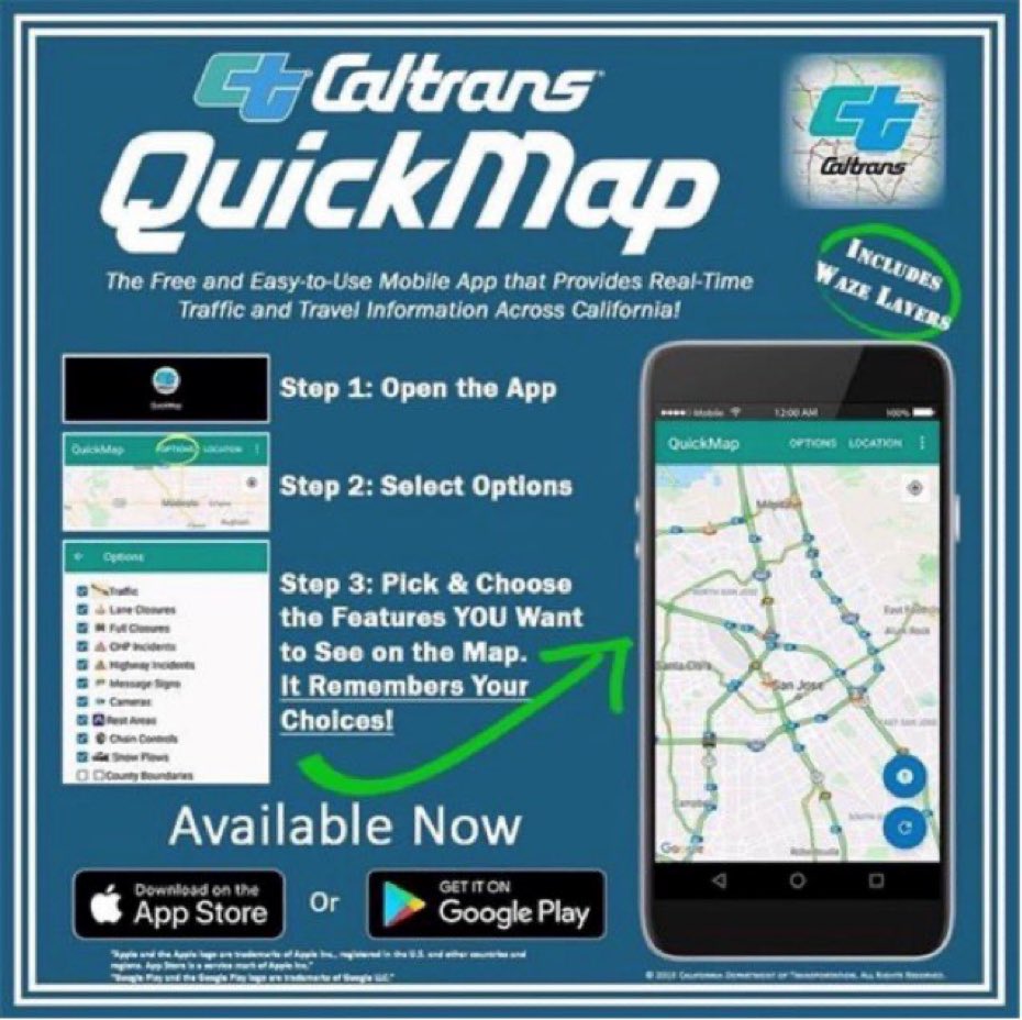
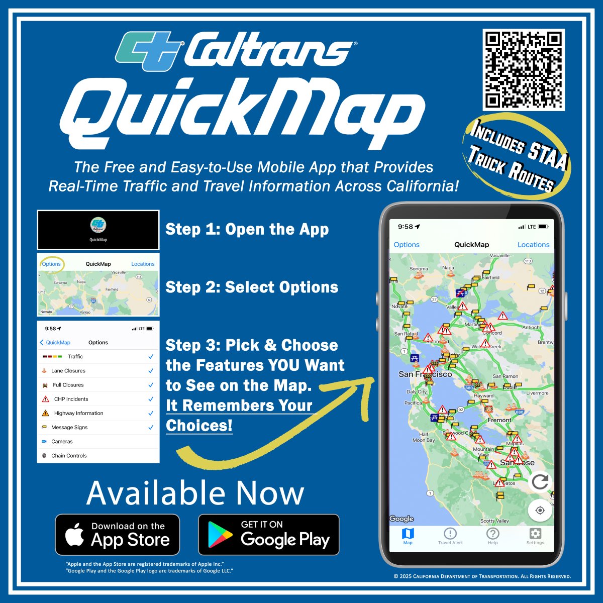
#quickmap search results
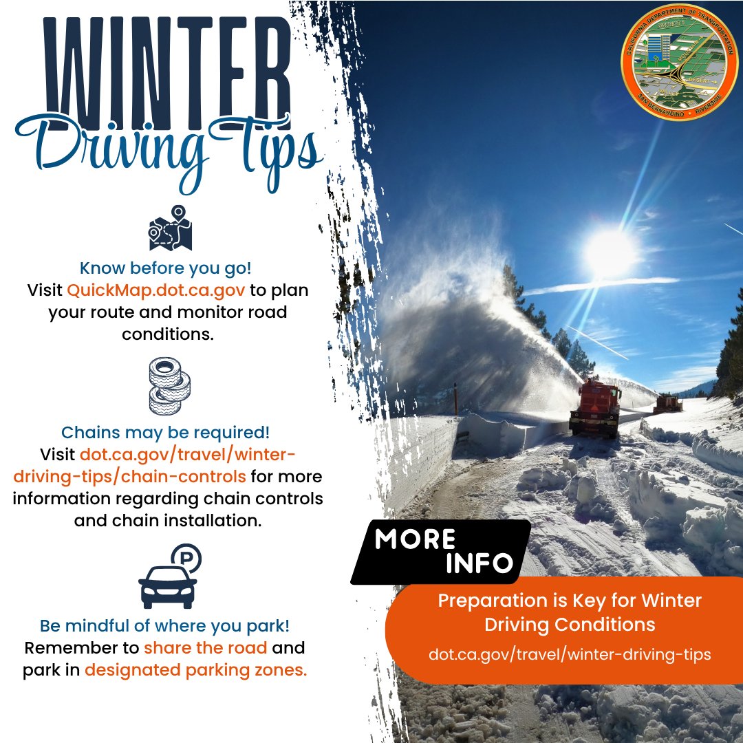
Winter storms are here, plan your travels accordingly. Check Quickmap.dot.ca.gov, visit dot.ca.gov/travel/winter-…, and check signage in the area to ensure you are parked in appropriate parking zones. #Caltrans8 #QuickMap #chaincontrol #SBCounty #RiversideCounty
SBCO: Chain control is being issued in the mountains. Check out #Quickmap to view locations of chain control and level. R2 conditions in many of the areas, so be prepared when traveling. Bring your chains with you, so if you must put them on, you have them. #Caltrans8

We have storms coming through our area, and we understand that people have places to be. If you must travel during the storms, try to remember some of these tips. Check #Quickmap and plan your travels accordingly. #Caltrans8


You’ve been warned, the next storm is looking to be a big hit just in time for the end to a holiday weekend. Make preparations now and #beprepared. Bookmark #quickmap and/or download the app for accurate and reliable roadway information.
Dry weather through Saturday! But coldest storm of the season so far will arrive later Sunday w/ periods of beneficial rain, gusty winds, & significant snow in the mountains. Lowering snow levels will cause difficult travel for the end of the holiday weekend. Plan ahead! #cawx
We got a ⛈️ coming. Crews are on 24/hr shifts, and will continue operations throughout the night. Chain control is up and running, use #Quickmap to see locations. Bring your chains when visiting the mountains so you are prepared if you are instructed to put them on. #Caltrans8
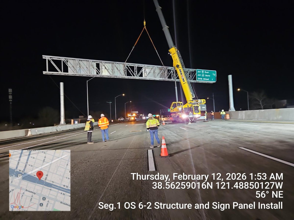
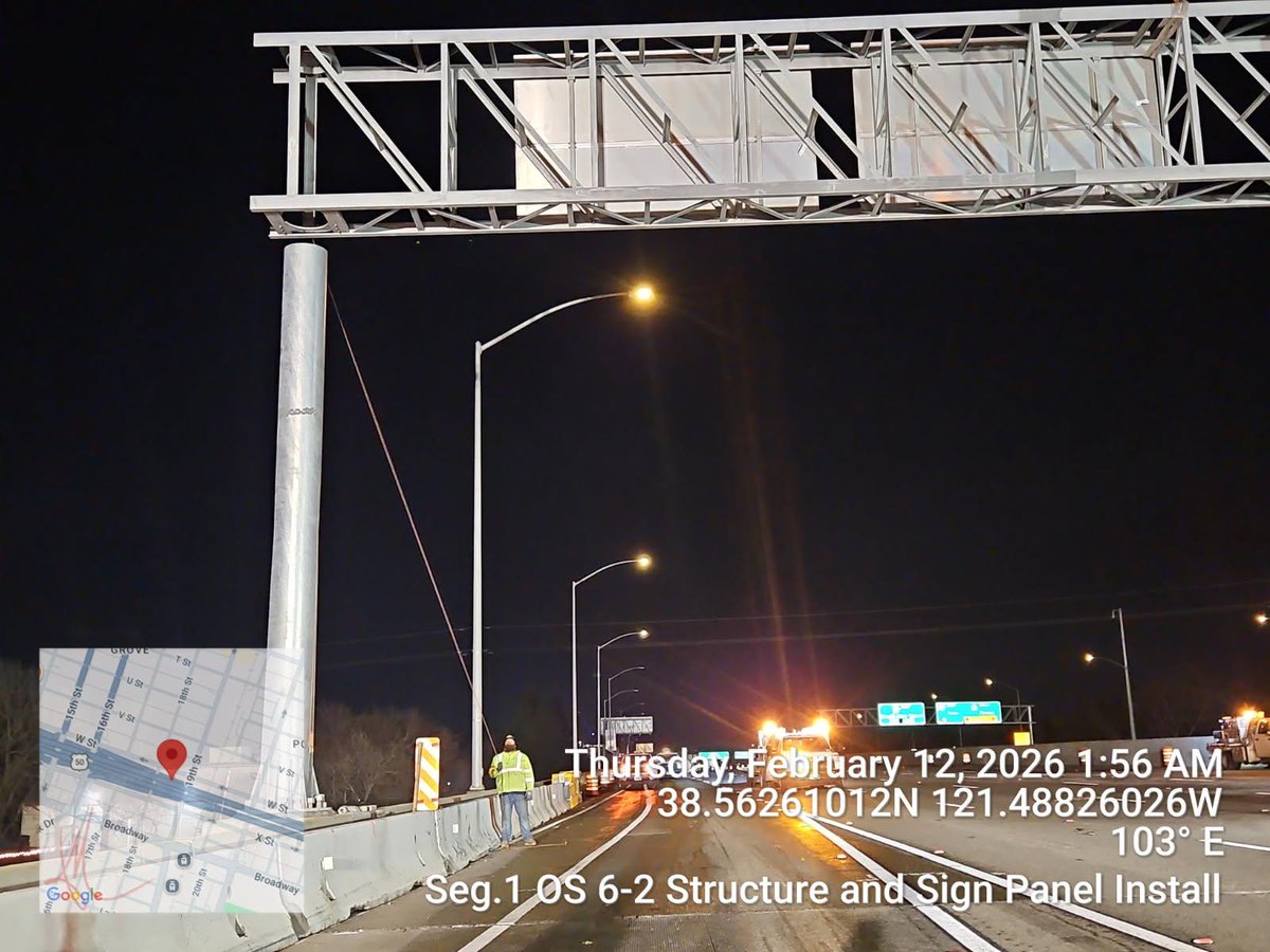
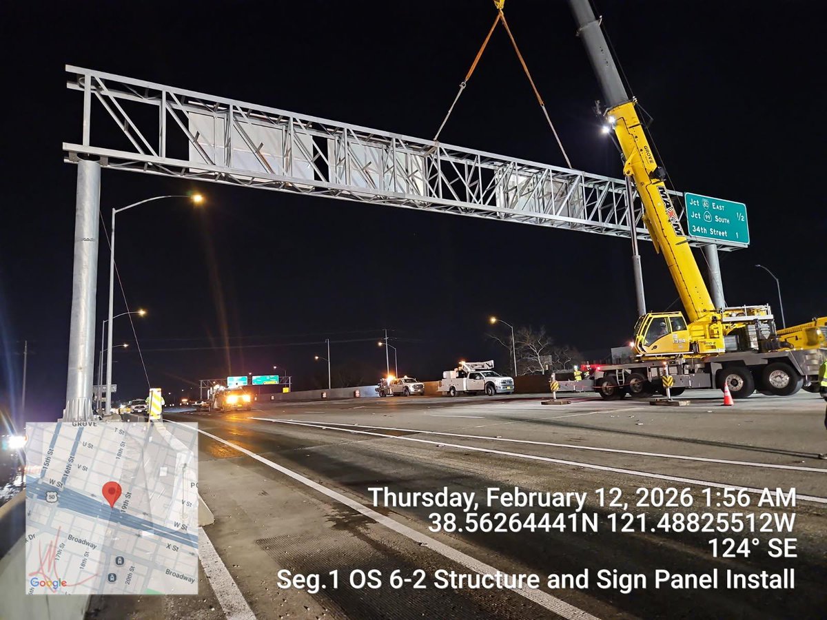
#Update The overhead sign installation that took place last night across westbound of the FIX50 project in Sacramento, was completed successfully by our crews and they were able to open the traffic break ahead of schedule. #KnowBeforeYouGo #QuickMap

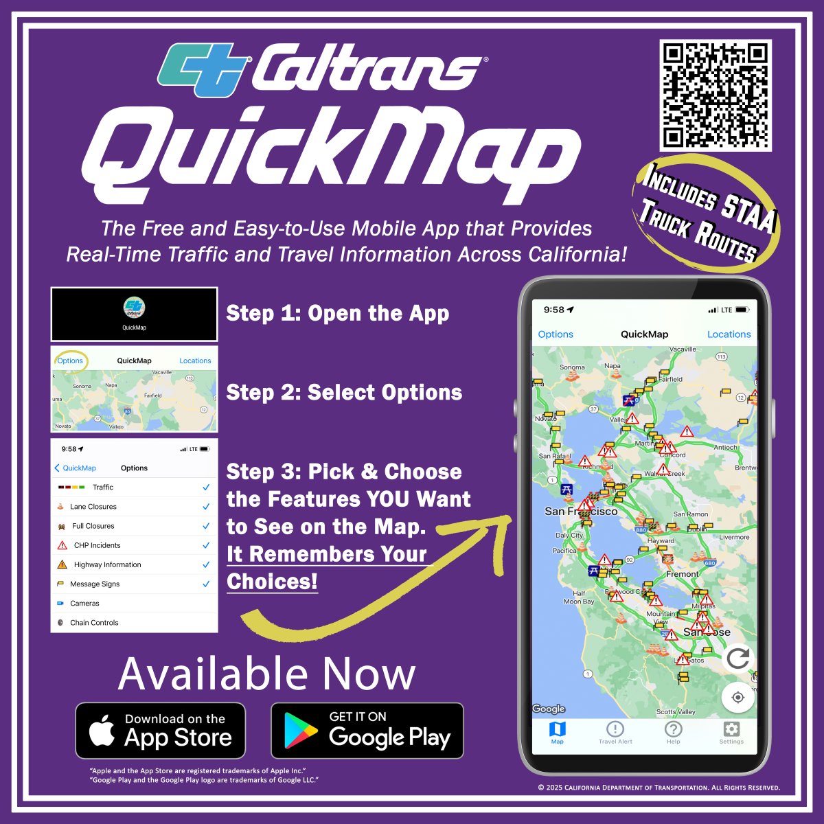
🚛🚚Attention California Truckers! Caltrans' real-time #QuickMap app now displays Truck Weigh Stations & color-coded CA Truck Networks routes. Compare routes if plans change. Activate layers in QuickMap.dot.ca.gov > Options > Commercial Vehicles. #CaTruckers #KnowBeforeYouGo

People will notice snow in areas where it’s not normally at. This storm is a big one, stay off the roads if able. #Quickmap will inform you of road conditions. Even the Cajon Pass has some snow right now. Slow down and leave room if you travel. #Caltrans8


Don’t be a dummy, hunny. Get those chains ready, cause certain areas are requiring you to chain up no matter what vehicle you have. Use #Quickmap to see locations and what level. If you don’t want to put on chains, then consider a different travel day. #Caltrans8

⚠️ Severe Storm Warning Feb 16-18 ⚠️ Mountain travel is not recommended however if you must travel, plan ahead & #KnowBeforeYouGo with our #QuickMap app or visit quickmap.dot.ca.gov for updates on chain controls & road closures. #BeSafe @CA_Trans_Agency @Cal_OES @CAgovernor
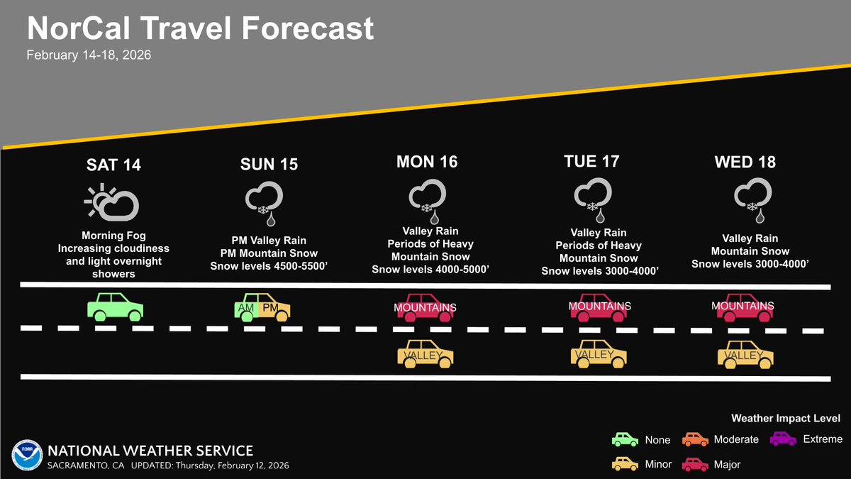
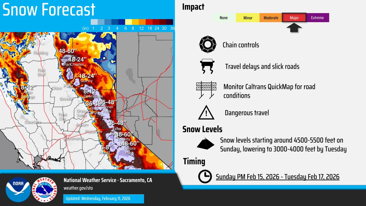
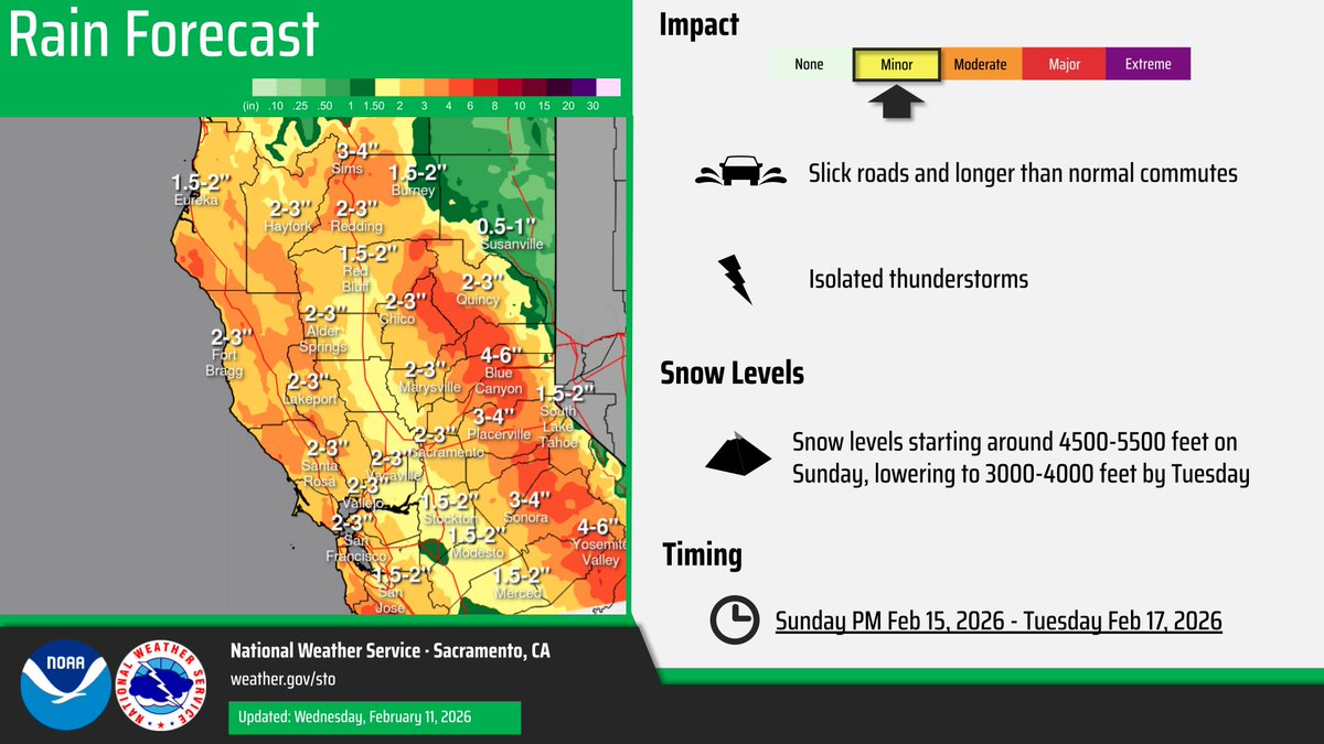
Widespread precipitation and heavy mountain/foothill snow will impact northern California the next few days. Thunderstorm development will be possible as well at times. Here is a look at potential timing! #CAwx
🌧️Rain is back in the forecast, with snow expected at higher elevations❄️ It hasn’t rained for a while - roads will be very slick! Slow down & give yourself extra travel time. Going on a trip? Check our #QuickMap app for real time info on closures, chain controls, and more!


Take one more precaution and download our #Quickmap app (free for your smartphone) for real time updates on chain controls, road closures and more. We like to say that it’s better to #KnowBeforeYouGo.

While much of the rain ⛈️and snow 🌨️across CA has ceased, Caltrans remains prepared to respond to impacts. 1766 maintenance personnel & 1306 pieces of equipment are positioned to take action to keep roadways open & safe. Travelling? 🛣️ check #QuickMap for current conditions


Remember to plan ahead for winter driving. Pack chains, snacks, water, emergency supplies and expect delays. The commute will take you longer, especially under chain control. Check #QuickMap for updates.

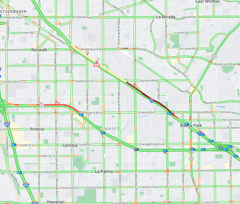
SB57 to SB5 All lanes closed due to traffic collision. HOV connector open. No eta on reopening. Use #Quickmap. #slowdown, @CaltransHQ
#TrafficAlert in Chico on State Route 99 Caltrans crews are assisting with a temporary full closure of SB SR 99 between East Avenue and Cohasset Road in Chico. The closure is expected to last approximately 30 minutes while work is completed. Stay up to date with #Quickmap App

With bad weather, road conditions can change quickly. Pay attention to warnings! If you need to travel, slow down, budget more time - and #KnowBeforeYouGo. Download @CaltransHQ #Quickmap at quickmap.dot.ca.gov to get up-to-date traffic information.
Lane blocked along westbound U.S. 50 near Echo Summit due to vehicle recovery and clean up after a truck hauling hay overturned. No ETO. Check #QuickMap for any updates.


Remember to plan ahead for winter driving. Pack chains, snacks, water, emergency supplies and expect delays. The commute will take you longer, especially under chain control. Check #QuickMap for updates.

#PlanAhead To view traffic advisories for this week's construction and maintenance projects, visit: dot.ca.gov/caltrans-near-…. #KnowBeforeYouGo with traffic and road closure info in real-time using quickmap.dot.ca.gov — or download the #Quickmap app on your mobile device.


Thanks @realwxforecast CAwx If planning to ski 🏂⛷️ Saturday & Sunday during the storm, best to check the hourly forecast to get to your high Sierra Lake Tahoe destination b4 the high wind gusts, heavy snow & thunderstorms hit ✅ @CaltransDist3’s #QuickMap 🚙☠️🌨️🧊🌬️🏔️
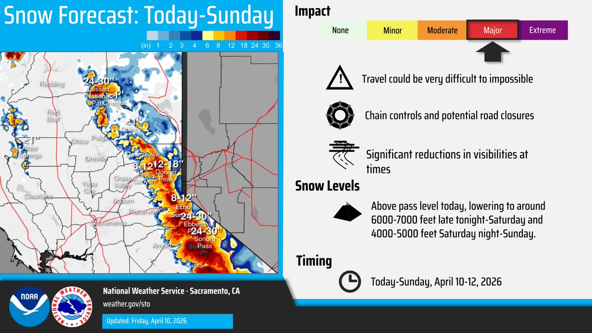
Sierra Nevada 🏔️NWS Winter Travel Advisory Heavy snow 6 to 10 inches for #LakeTahoe to 7k feet, 12 to 28 inches above 7k feet & for #Sierra passes Winds gust 90 mph over ridges 20-35 mph low elevation From 2 PM Saturday April 11 to 11 PM Sunday Thunderstorms = ⚠️🛑🚠🚡 #CAwx


Guess it’s going to be one of those springs. Showers, thunderstorms and even snow is in the forecast for the Sierra through this weekend. #knowbeforeyougo and check #quickmap for real time road conditions.


#TrafficAlert #MercedCounty SR-165 closed from River Rd. to Turner Ave. due to an incident involving an overturned big rig. No ETO. Motorists should avoid this route. For traffic and closure information in real-time use Quickmap.dot.ca.gov. #QuickMap

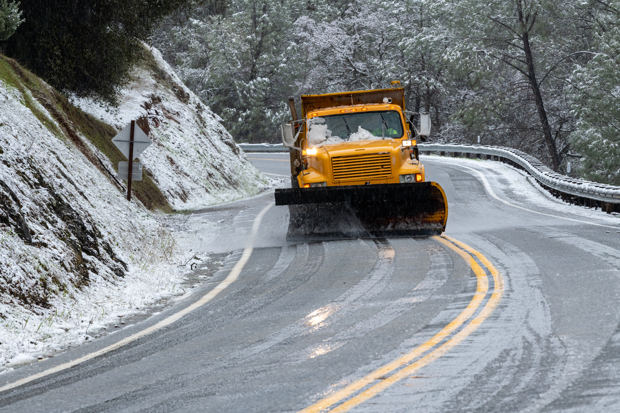
Chains controls are still up along I-80 this morning. Take it slow and check #QuickMap for any updates. As of 7:45 a.m. EB (R2) Kingvale to Truckee, WB Donner Lake Interchange to Rainbow. Trucks: Turning all single pulling doubles at Applegate and DLI.
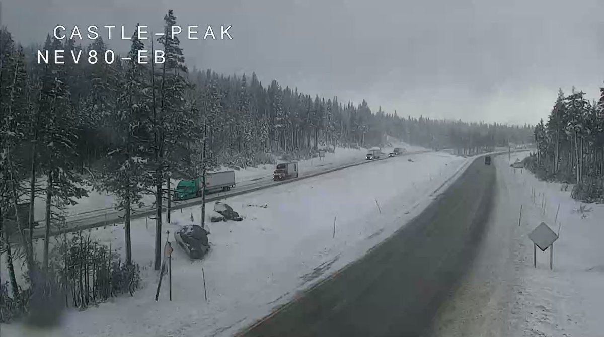
Chain controls up on I-80 Winter🥶 wonderland revisits Check @CaltransDist3 #Caltrans #QuickMap before, during your drive to the high Sierra Nevada mountains #LakeTahoe quickmap.dot.ca.gov/mindex.html Stay safe Increase 🚙🚐 distance Downshift low gear 🏔️
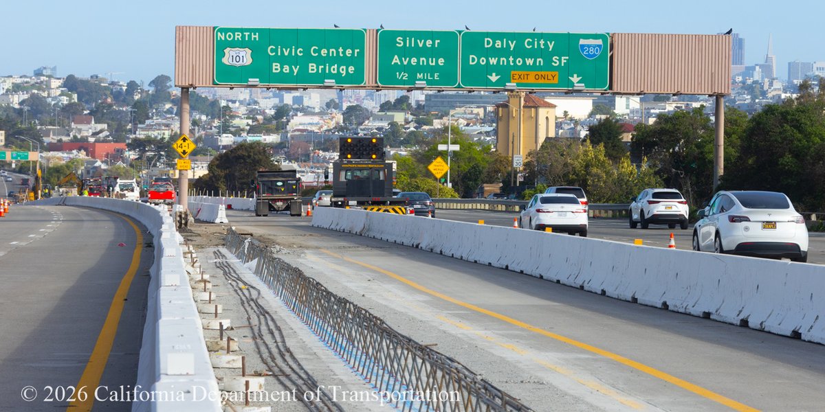
SF-Bay Area Motorists! Avoid delays🚘while U.S. 101 Bayshore Freeway (Hospital Curve) weekend work and lane reductions are underway thru Monday, 7 a.m. Consider using detour. Visit sfhighwayprojects.com to learn more about #Fab4 projects. Check #Quickmap🚧

Update: SB Lane at Blue Oaks is open. However a new traffic collision has taken place this time northbound 65 near Blue Oaks. Take caution and slow down. Check #QuickMap for updates and real time roadway conditions.
#TrafficAlert Lane blocked along southbound SR 65 at Blue Oaks Blvd due to a traffic collision. Traffic is currently backed up just past Sunset Blvd. Expect delays. No ETO.

#PlanAhead: To view traffic advisories for this week's construction and maintenance projects, visit: dot.ca.gov/caltrans-near-…. #KnowBeforeYouGo with traffic and road closure info in real-time using quickmap.dot.ca.gov — or download the #quickmap app on your mobile device.
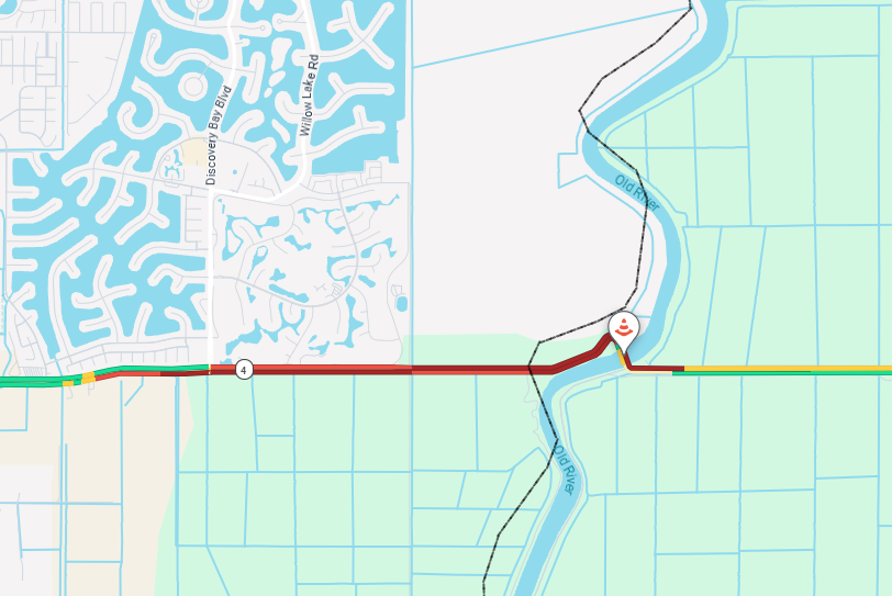
#TrafficAlert Traffic stopped in both directions on SR-4 at #DiscoveryBay due to a traffic incident. No ETO. Seek alternate route. For the latest traffic conditions and highway information download the #Quickmap app on your mobile device.

@CaltransHQ Leave it to the state of California to take something wonderful like #QuickMap, and completely ruin it. And then send the taxpayers the bill. Worthless organization.
Check #QuickMap for any updates.

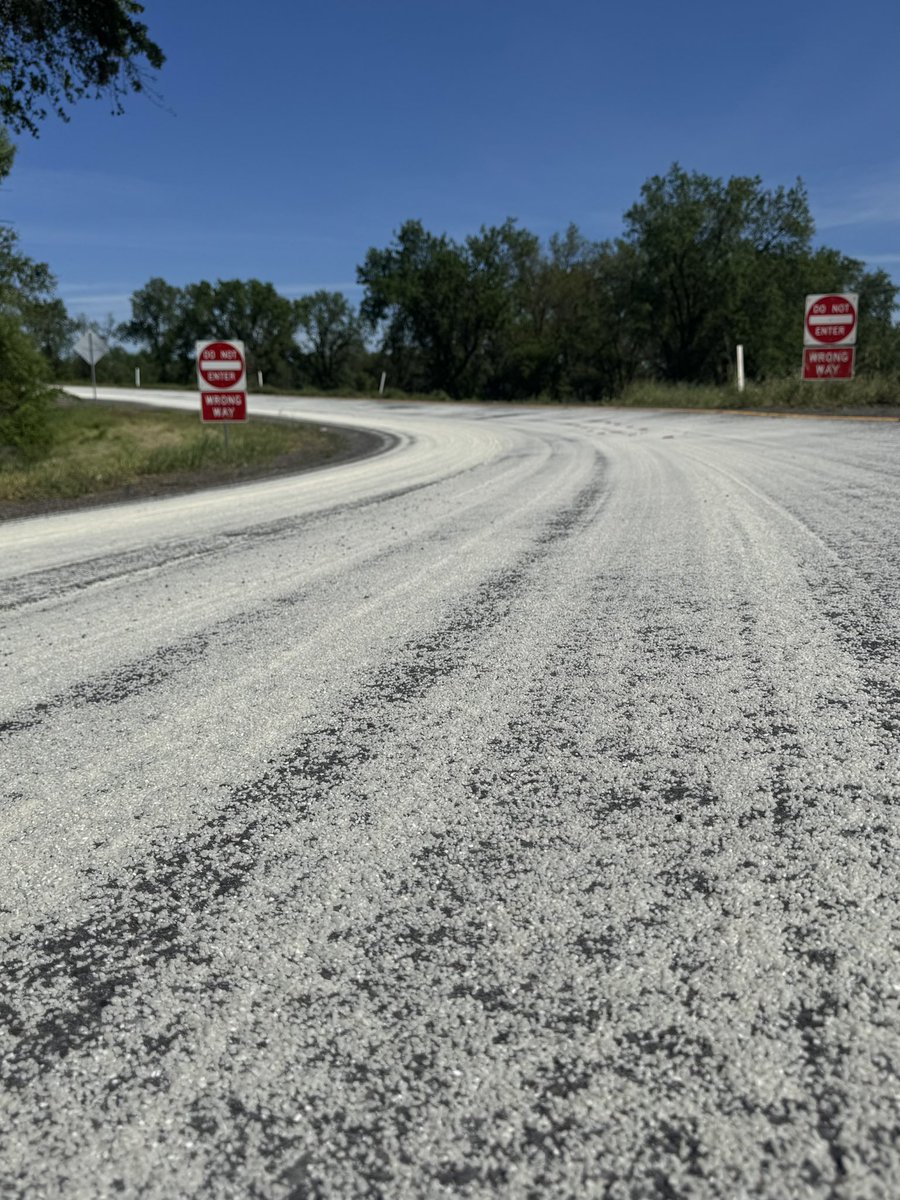
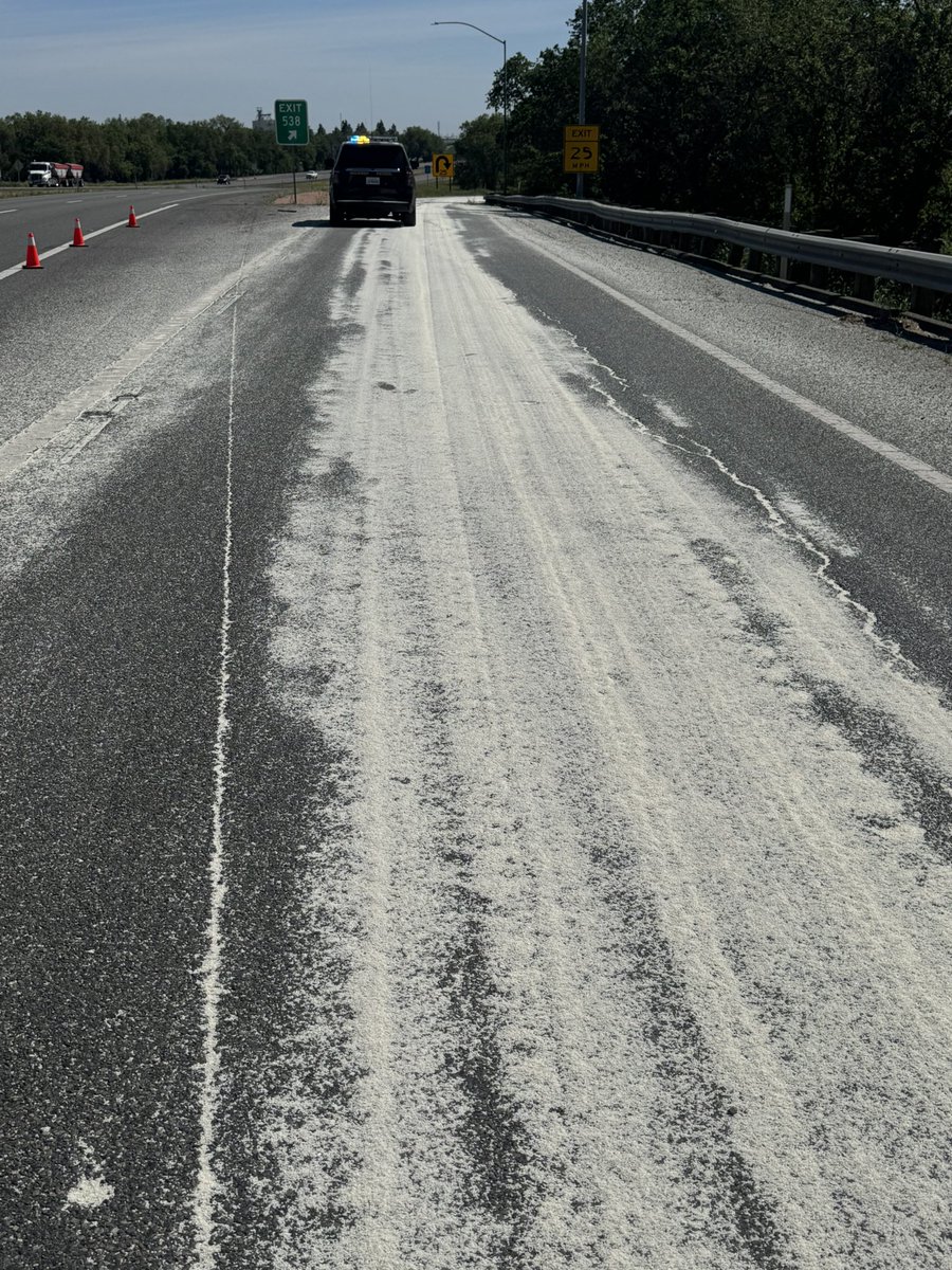
TRAFFIC ADVISORY: I-5 SB to SR-113 North The off-ramp from I-5 southbound to SR-113 north is closed due to a commercial vehicle spilling a load of rice. Crews are on scene working to clear the roadway. Unknown ETO. 03/17/2026 @ 1:53 p.m.
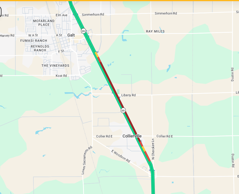
#TrafficAlert 3/16/2026 8:30 am. Due to a vehicle on fire on northbound SR 99 in the Central Galt exit area, there is significant back up on SR 99. Please use alternate routes or avoid the area. No ETO. #KnowBeforeYouGo #quickmap
More images from the weekend project underway on the U.S. 101 Bayshore Freeway. Work will be completed by 6 a.m. Monday, until then plan early and refer to #Quickmap and download our detour to avoid delays at sfhighwayprojects.com
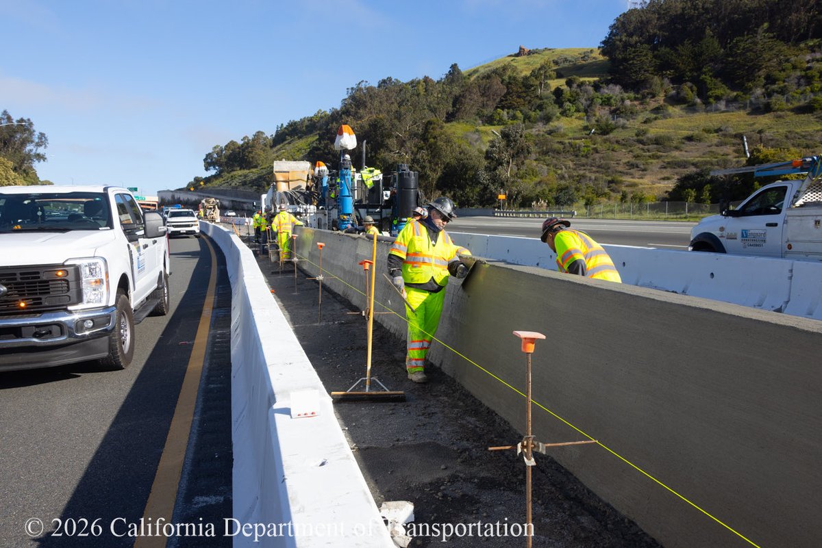
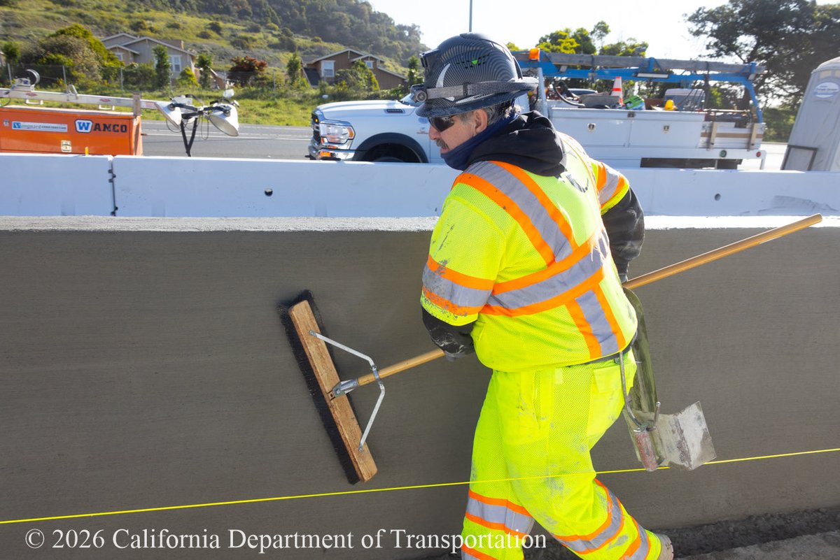
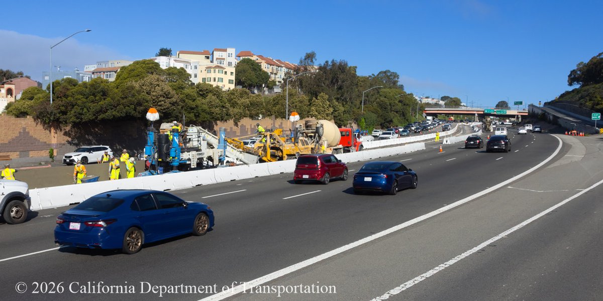
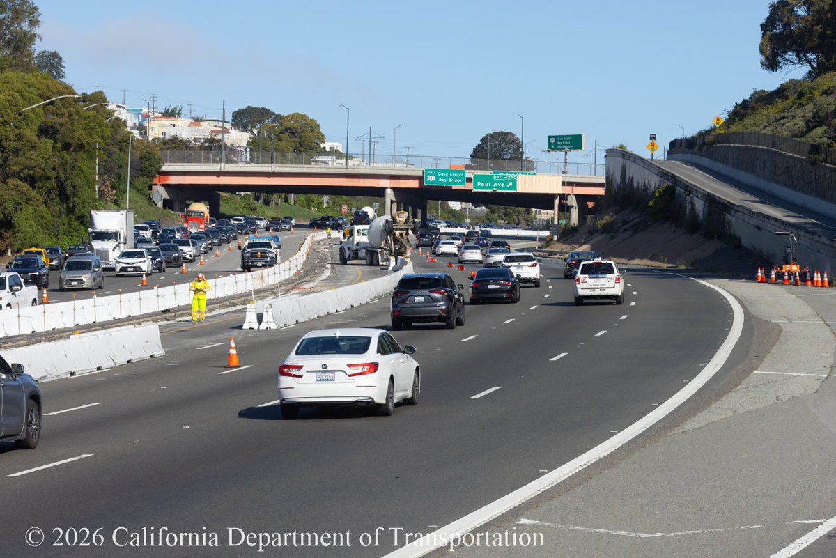
Weekend work along U.S. 101 Bayshore Freeway in SF near Candlestick Point Area is near complete thanks to a dedicated crew. Motorists should remember to plan early and refer to #Quickmap to avoid delays. Also visit sfhighwayprojects.com to learn more! #sfcta #sfmta #kcbs

Caltran crews are making progress in SF on the U.S. 101 Bayshore Freeway (Hospital Curve) this am. Motorists traveling between Silver and Candlestick Pt. Area, can expect delays while lane reductions are in place. Plan early, check #Quickmap Learn more at sfhighwayprojects.com
#TrafficAlert SR-4 is under one-way traffic control at Stallion Way in Calaveras County due to a traffic Incident. No ETO. Expect delays or seek alternate route. For the latest traffic conditions and highway information download the #Quickmap app on your mobile device.


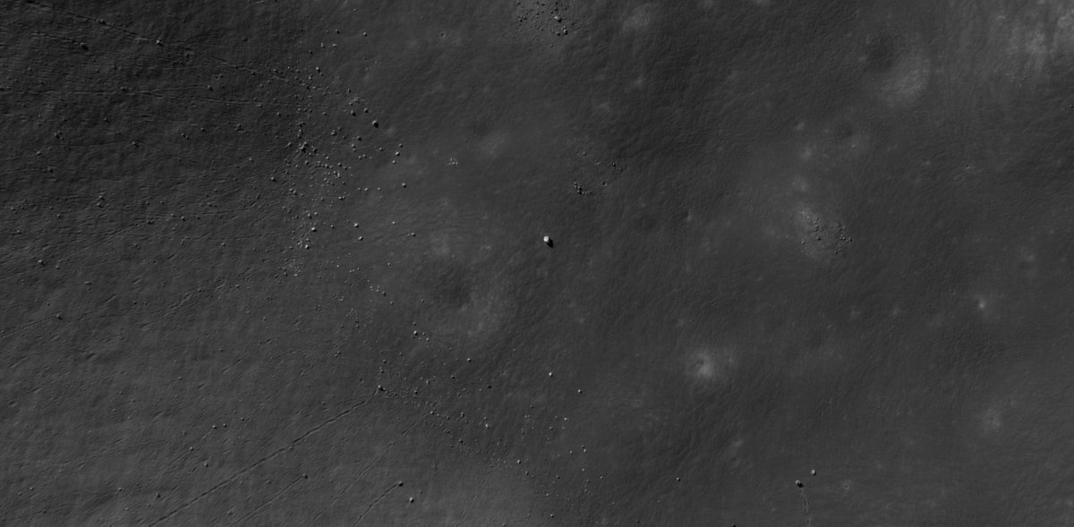
¡ya Estamos en la Lunal! 💙🌑 #spacex mode con @grok oservando Encontré esta roca blanca enorme y brillante en #QuickMap LROC – la más grande del área, aislada total, sin rastro de huellas o rodadas. Científicamente: boulder de alta reflectancia (material fresco sin weathering),
⚠️ Plan Ahead and #KnowBeforeYouGo with our #Quickmap app for latest info on road closures, chain controls and more. Please be safe! 🚗 💨 QuickMap.dot.ca.gov
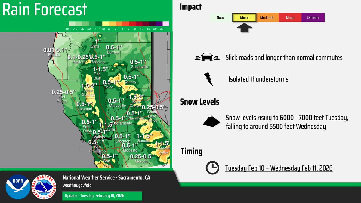
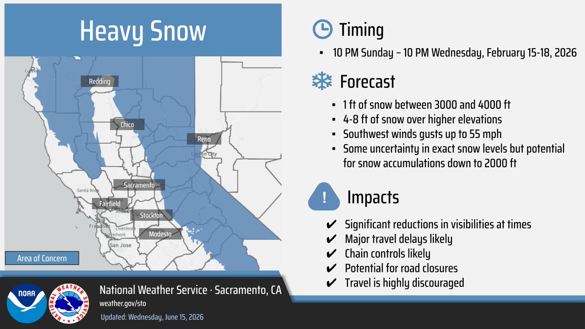
Precipitation is spreading inland across portions of interior NorCal mainly in Shasta and Tehama counties so far. Here is a look at latest RADAR. Plan ahead for slick roads on the evening commute! #CAwx


🚗 Drivers — Before you hit the road, check our free #QuickMap app or visit QuickMap.dot.ca.gov for the latest updates on road closures, chain controls, and more. Stay informed, travel safe! 🛣️ #knowbeforeyougo #drivesafely @CaltransHQ @CHP_HQ #caltransD4 #SlowFortheConeZone
Caltran crews are making progress in SF on the U.S. 101 Bayshore Freeway (Hospital Curve) this am. Motorists traveling between Silver and Candlestick Pt. Area, can expect delays while lane reductions are in place. Plan early, check #Quickmap Learn more at sfhighwayprojects.com

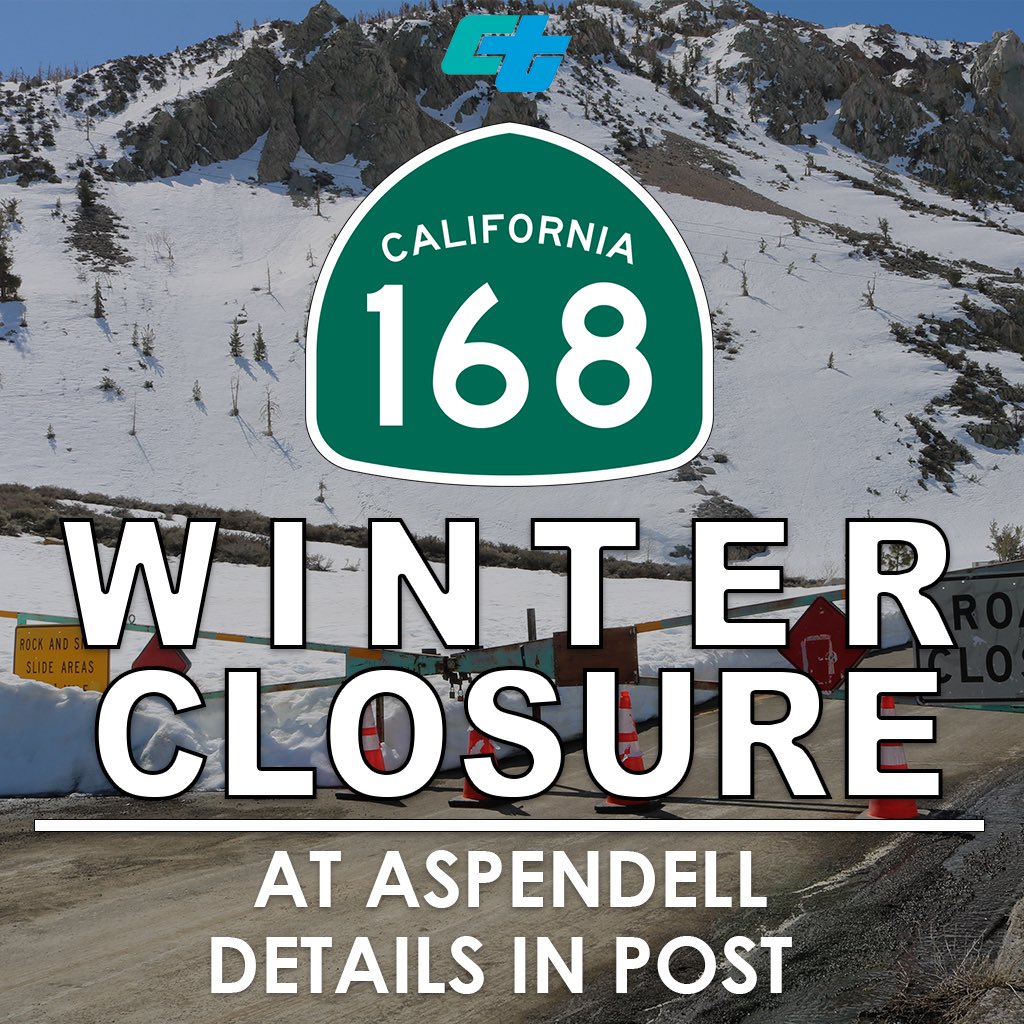
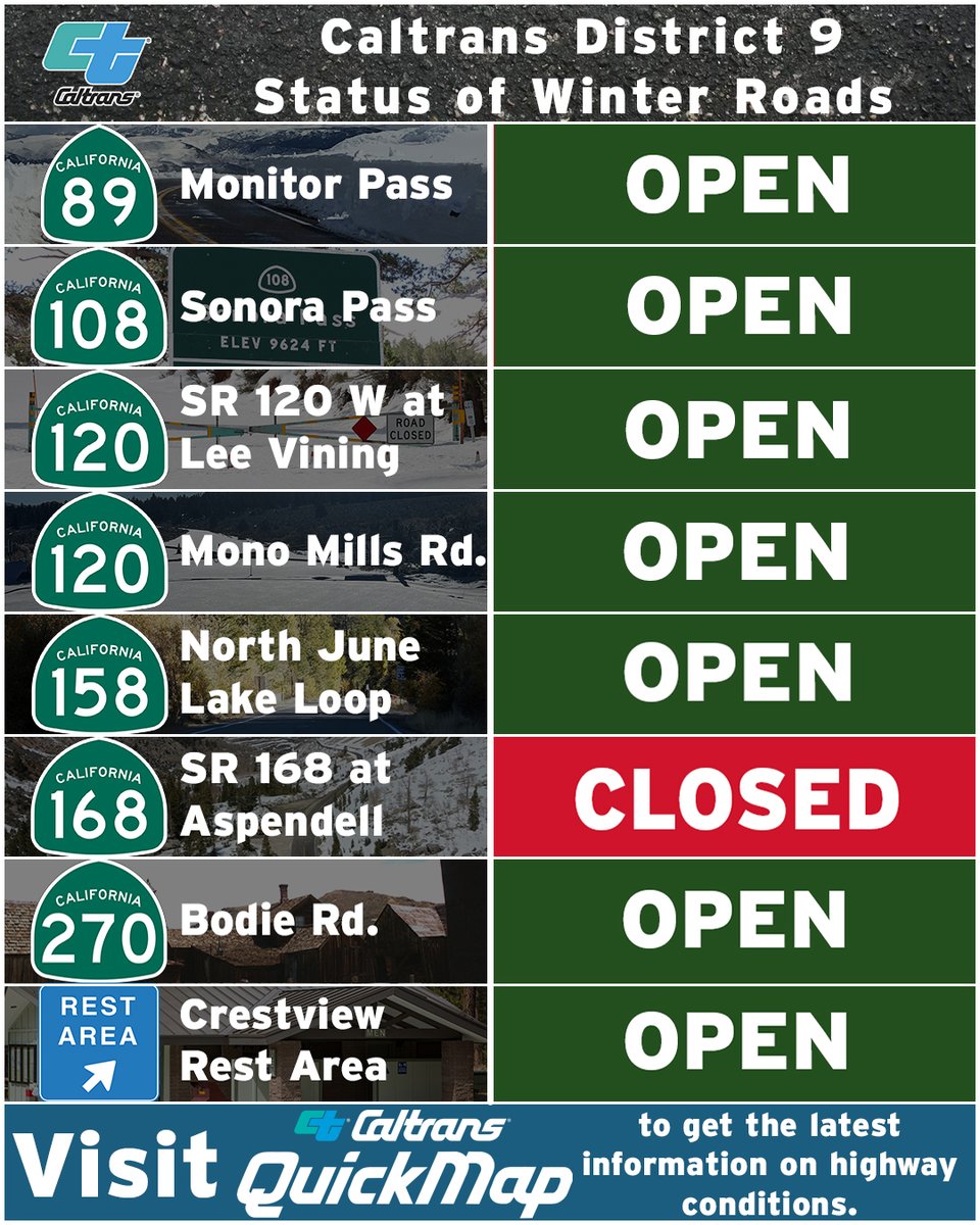
State Route 168 above Aspendell to Lake Sabrina is closed for the winter season. Check quickmap.dot.ca.gov or download the Quickmap app to obtain the latest information on California highway conditions. #Quickmap
Caltrans offices will be closed on Monday, March 31 in observation of Cesar Chavez Day. If you have travel plans, please #KnowBeforeYouGo and check our #QuickMap app or visit QuickMap.dot.ca.gov for up-to-date information on road conditions, chain-controls and more!

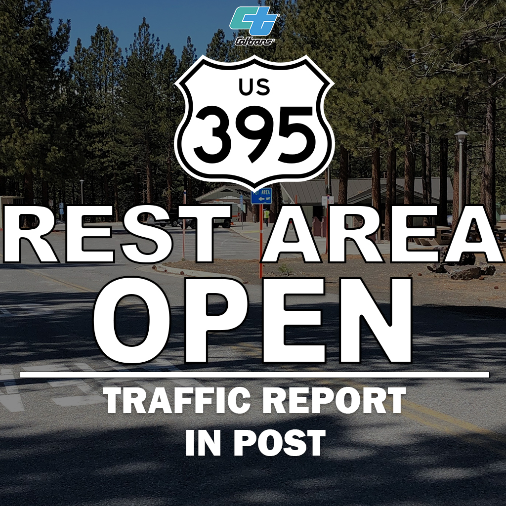
Crestview Rest Area, north of Mammoth Lakes is now OPEN after being temporarily closed for upgrades by Southern California Edison (SCE). For the latest updates on highway conditions, visit QuickMap at quickmap.dot.ca.gov or download the #QuickMap mobile app.
Remember to plan ahead for winter driving. Pack chains, snacks, water, emergency supplies and expect delays. The commute will take you longer, especially under chain control. Check #QuickMap for updates.
Here is the current status of our winter roads. For the latest updates on highway conditions, visit QuickMap or download the #QuickMap mobile app.
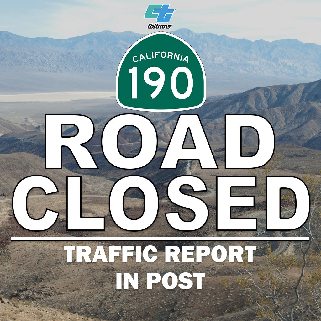
UPDATE: Due to storm debris, State Route 190 is additionally closed from the junction of State Route 136 to 2 miles west of Saline Valley Road. Check quickmap.dot.ca.gov for the latest information on California highway conditions. #Quickmap

Crestview Rest Area is closed due to inclement weather. We will assess the reopening of the area once the winter storm passes in Mono County. Check quickmap.dot.ca.gov or download the Quickmap app to obtain the latest information on California highway conditions. #Quickmap

State Route 190 is open and accessible via State Route 136 from U.S. 395. The roadway remains closed from 4 miles east of Olancha to the junction of SR 136 as Caltrans crews continue to clean up mud and debris. Visit #QuickMap for the latest updates on CA highway conditions.

If you have plans to travel during this latest round of heavy rain 🌧️ and snowstorms ⛄️ download our #Quickmap ap for updates on road closures, chain controls and more. Always better to #KnowBeforeYouGo! Please be safe! 🚙 💨

Snow earlier this week = appetizer. Snow next week = MAIN COURSE. Check the forecast and monitor #QuickMap for real-time roadway information. More details here, conta.cc/4rOw2iP @CHPGoldRun @CHP_Truckee @chp_donnerpass @CHPgv @CHPSouthLake @CHPPlacerville @CHP_Quincy

Due to flooding, State Route 190 is closed from 4 miles east of Olancha to State Route 136. Please visit quickmap.dot.ca.gov or download the Quickmap app for the latest updates on California highway conditions. #Quickmap
🎆 Caltrans will pause all scheduled highway work over Labor Day weekend to keep traffic moving. 📲 Check real-time traffic & road conditions on QuickMap: QuickMap.dot.ca.gov ✅ Drive safe | Plan ahead | Celebrate responsibly #LaborDayTravel #QuickMap
Highway Highlights – September 10, 2025: ⚠️For our latest road conditions and updates, visit the Caltrans #Quickmap at QuickMap.dot.ca.gov or call 1-800-427-ROAD.


It’s the busiest travel week of the year! 🚗✈️🚂 Always better to KNOW BEFORE YOU GO, check #Quickmap to find the best traffic routes, closed roads, chain controls & more to arrive safely at your holiday destination. Download the app or visit QuickMap.dot.ca.gov #BeSafe

#California, brace for the #PineappleExpress storm! 1️⃣ Limit travel. 2️⃣ Keep distance & slow down. 3️⃣ Avoid flood-prone areas. 4️⃣ Check your vehicle's safety features. 5️⃣ Stay updated: #Quickmap or 📞 1-800-427-ROAD Stay safe & informed! #weather #sandiego #losangeles #storm
Weekend work along U.S. 101 Bayshore Freeway in SF near Candlestick Point Area is near complete thanks to a dedicated crew. Motorists should remember to plan early and refer to #Quickmap to avoid delays. Also visit sfhighwayprojects.com to learn more! #sfcta #sfmta #kcbs
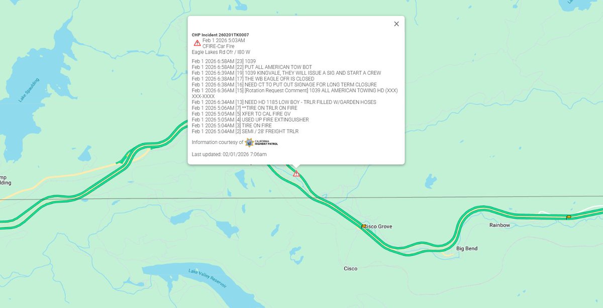
#TrafficAlert | County of Nevada, CA | 2/1/2026 at 7:12 a.m. Caltrans has closed Exit 164 on State Route 80 due to a vehicle fire. A long-term closure is expected while crews complete cleanup operations. Check #QuickMap for real time updates on closure.
State Route 120 to Yosemite National Park is closed due to incoming inclement weather. Check quickmap.dot.ca.gov or download the Quickmap app to get the latest information on California highway conditions. #Quickmap

Something went wrong.
Something went wrong.
United States Trends
- 1. Artemis II N/A
- 2. Swalwell N/A
- 3. #SmackDown N/A
- 4. #NASA N/A
- 5. Rory N/A
- 6. #DragRace N/A
- 7. Royce Keys N/A
- 8. Pacific Ocean N/A
- 9. Luis Gil N/A
- 10. #BINI_CoachellaWk1 N/A
- 11. Katie Porter N/A
- 12. THEY MADE IT N/A
- 13. Lindsey N/A
- 14. Wicks N/A
- 15. Steyer N/A
- 16. Al Franken N/A
- 17. San Diego N/A
- 18. Astronauts N/A
- 19. Luzardo N/A
- 20. Matt Olson N/A