#slinkfire 検索結果

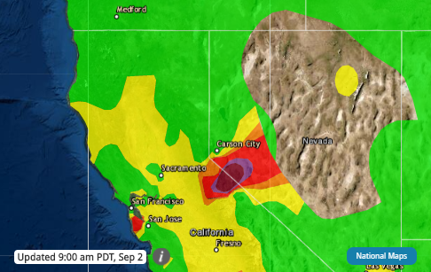
Air crews dropped fire retardant and water to contain the #SlinkFire, as firefighters battled the blaze burning near California’s border with Nevada. As of September 2, the fire, located near Coleville, #California, was estimated to be roughly 14,200 acres. #cawx #nvwx

#SlinkFire #NV #NVHTF bit.ly/3jyqCpb Slink Fire: new photos have been uploaded to this incident

Air crews dropping fire retardant on the #SlinkFire, as firefighters battled the blaze burning near California’s border with Nevada. The fire located near Coleville, CA was roughly around 14,000 acres as of Sept 2nd. Permission: Humboldt Toiyabe NF @WeatherBug #California

According to the USFS, smoke from the #CreekFire #SQFComplexFire and #SlinkFire will impact 🌬️Reno area 🌬️Carson City area 🌬️Tahoe area #Nevada #California #CaliforniaFires
630 AM: Camera looking at the smoke plume and smoke filled areas from the #SlinkFire west of Hwy 395/the Antelope Valley. Air quality has also decreased in the Sierra Valley and Reno-Sparks area. For the latest air quality, bit.ly/oZY8K

#SlinkFire #NV #NVHTF bit.ly/3iByqGk Slink Fire: Smoke Outlook for 9/15 - 9/16 Humboldt-Toiyabe NF - Slink Fire
#SlinkFire #NV #NVHTF bit.ly/3iPgtEF Slink Fire: Slink Fire Morning Update 9.16.2020

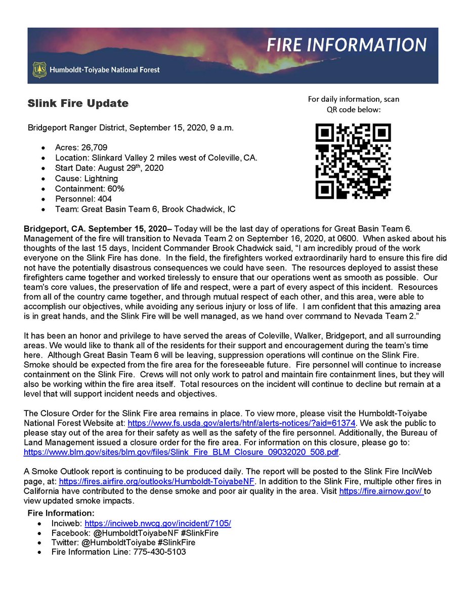
#SlinkFire #NV #NVHTF bit.ly/3hxLKud Slink Fire: 9/15/2020 Slink Fire Update
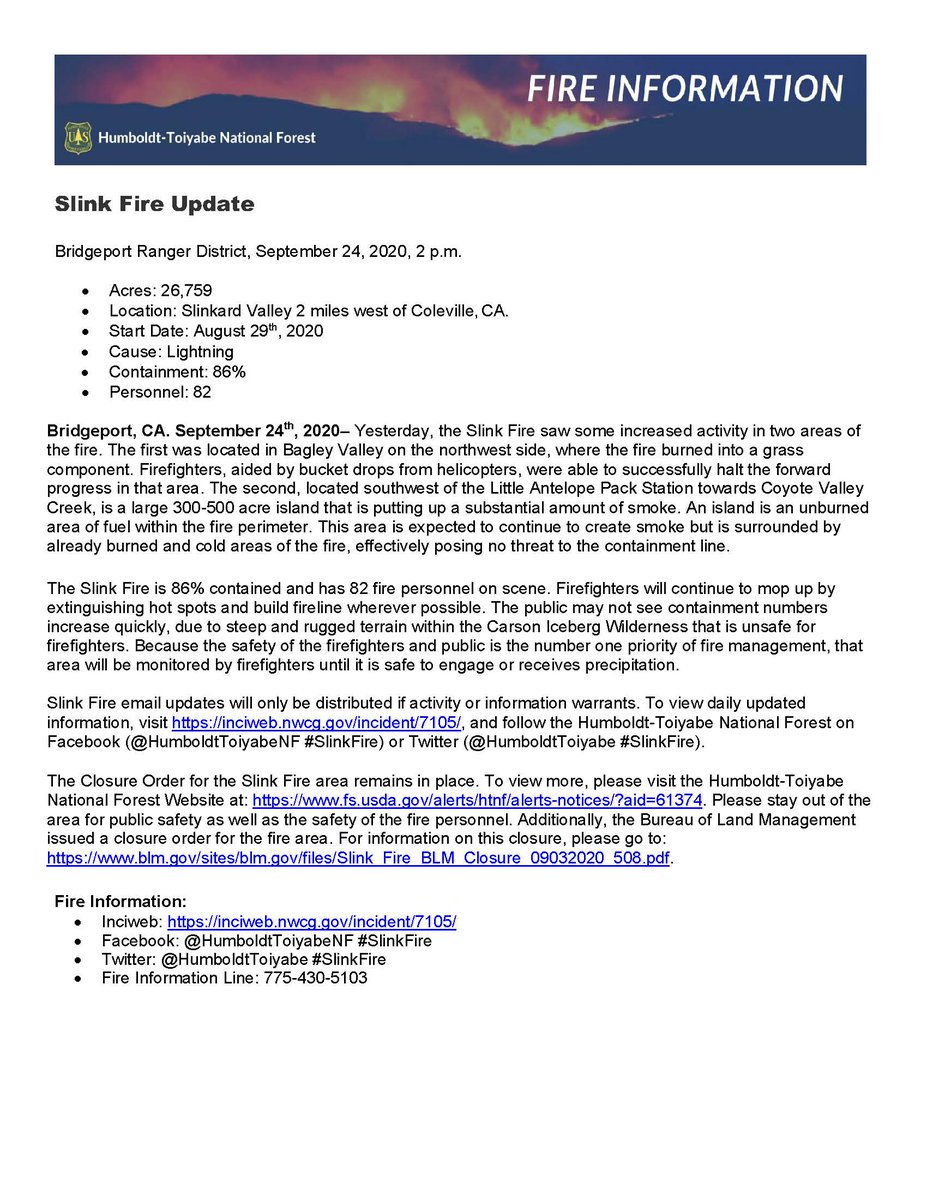
Fresno County: #CreekFire 379,895 acres 95% contained Mono County: #SlinkFire 26,759 acres 90% contained #MountainviewFire 20,385 acres 70% contained Monterey County: #DolanFire 124,924 acres 98% contained #ColemanFire 574 acres 98% contained

Latest update from the #SlinkFire burning southeast of the Tahoe Basin.
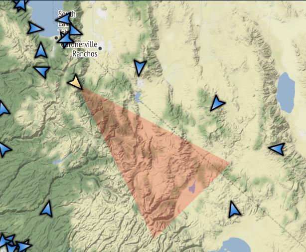
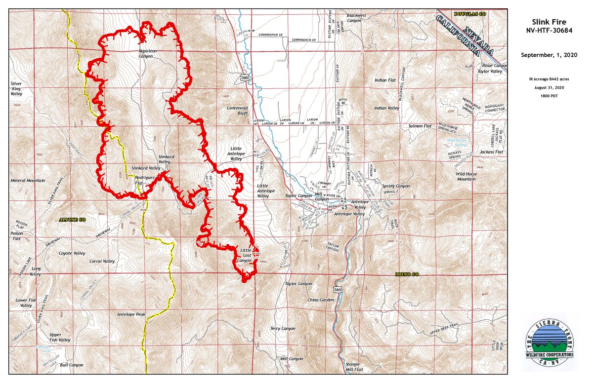
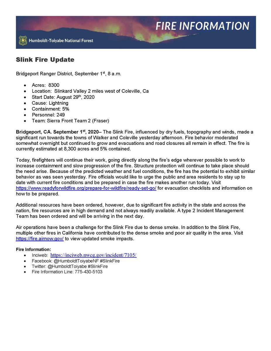
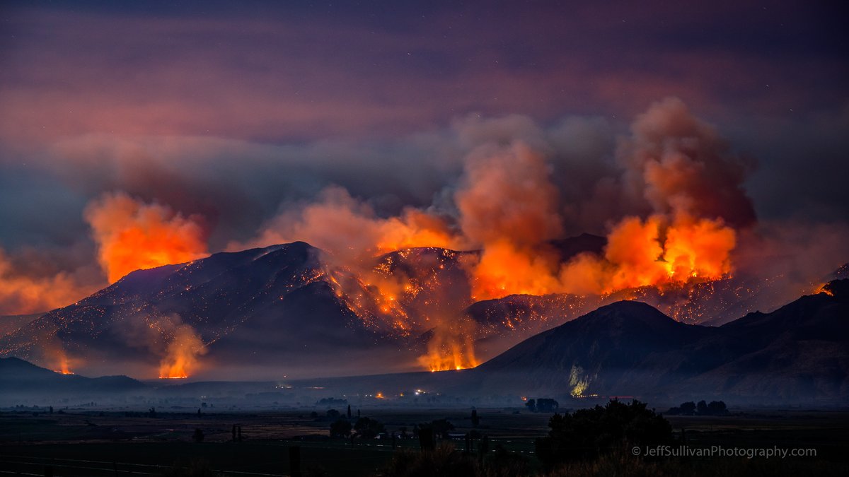
The #SlinkFire made a significant run towards the towns of Walker and Coleville yesterday afternoon. Fire behavior moderated somewhat overnight but continued to grow and evacuations and road closures all remain in effect. Fire is currently 8,300 acres. inciweb.nwcg.gov/incident/7105/
#SlinkFire #NV #NVHTF bit.ly/31uV8t9 Slink Fire: Reduction of Slink Fire Closure
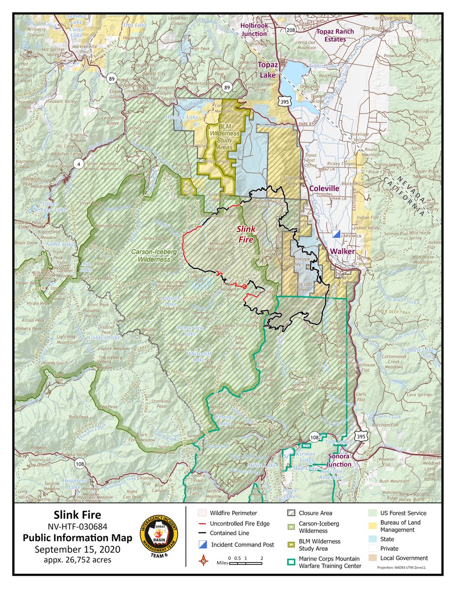
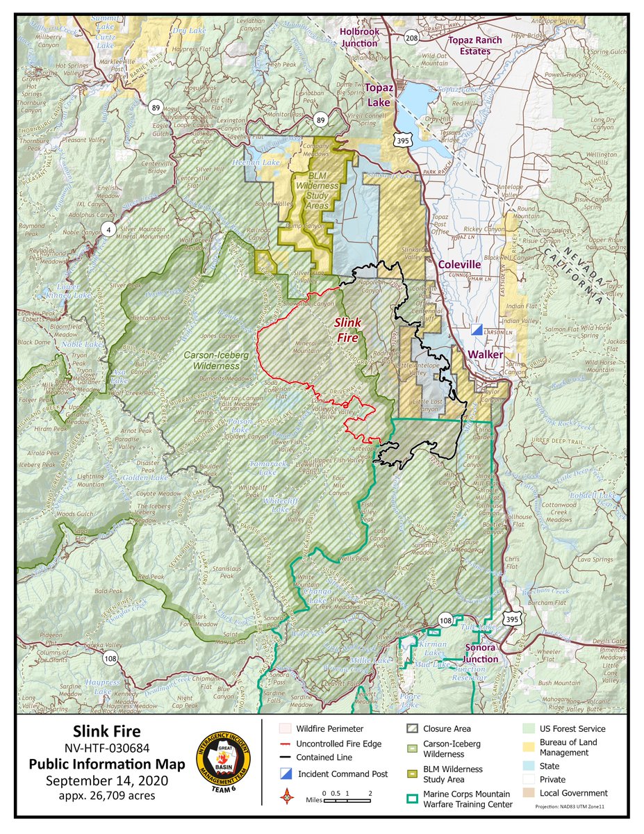
#SlinkFire #NV #NVHTF bit.ly/3hLi3Xl Slink Fire: new maps have been uploaded to this incident
#SlinkFire #NV #NVHTF bit.ly/33yxhsV Slink Fire: Final Smoke Outlook for 9/16-9/17

The #SlinkFire made a significant run towards the towns of Walker & Coleville yesterday. Fire behavior slowed overnight but continued to grow; evacuations & road closures all remain in effect. The fire is now 8,300 acres & 5% contained. #FireYear2020 go.usa.gov/xG4RM


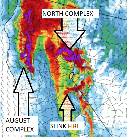
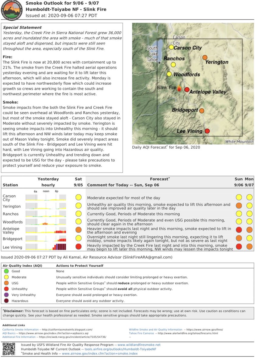
There will be wildfire smoke this #LaborDayWeekend. We set the forecast to Unhealthy for Sensitive Groups for PM2.5 and ozone in Reno/Sparks. Below shows a model run from last night for this morning with the #NorthComplex, #SlinkFire, #AugustComplex plumes surrounding Lake Tahoe.
WOW! Take a look at this Firenado Monday!🔥🌪️ 🔥 This was on the #SlinkFire near Coleville, California! Permission: Humboldt Toiyabe NF | Aug 31, 2020 @WeatherBug - Download the app today!

#Caldera500 update: #SlinkFire now at 10% containment, evacuation orders were lifted and the 395 is back open. We drove to Walker this afternoon, assessed the situation, and made a plan to leave Thursday morning around 1am. We’re hoping it only continues to improve from here. 🤞
The #SlinkFire behavior moderated today and hard work by firefighters has increased the containment to 10%. Please see the evening update below.

Sad for Walker, tonight. First the #SlinkFire, now this. Crazy.

25 minute timelapse of the extremely dangerous #MountainviewFire located near Walker in Mono County. Notice the lenticular clouds behind the pyrocumulus plume indicative of an unstable atmosphere. #CAwx #CAfire
Enjoy the fresh air while it lasts. Unfortunately, smoke from the #NorthComplexFire and the #SlinkFire will impact Reno/Sparks starting this afternoon/evening. Expect Unhealthy for Sensitive Groups to Unhealthy air quality at times. #BeSmokeSmart

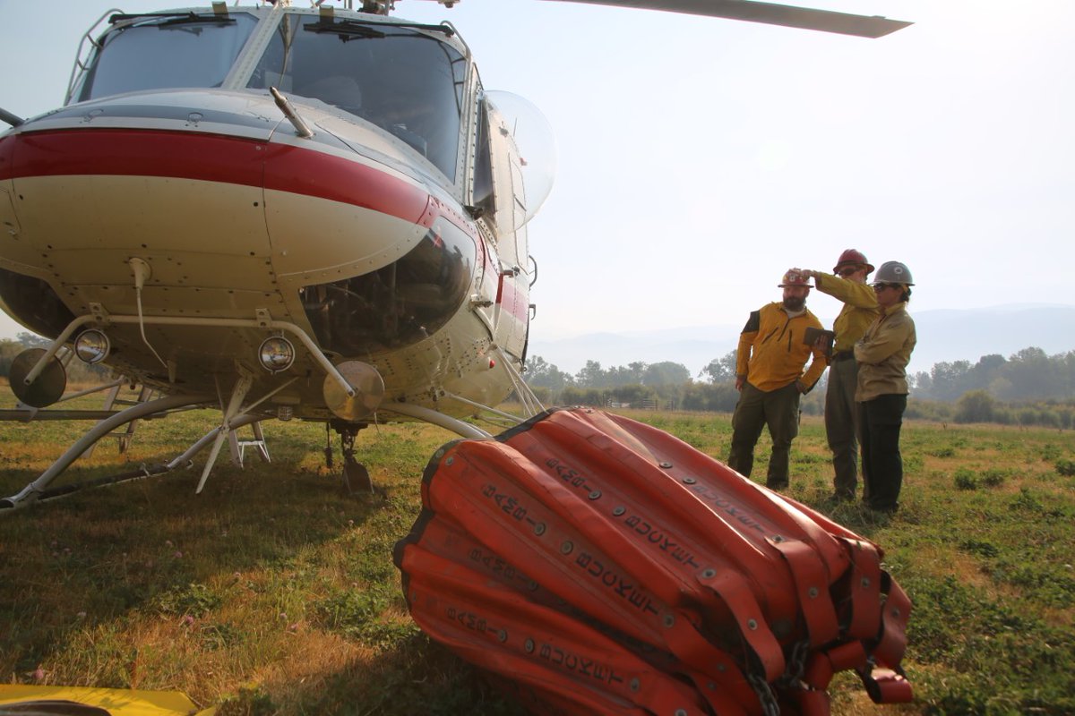
Fremont Fire Engineer Tim Bender is one of 16 firefighters deployed last night on the CAL OES swift water rescue team strategically prepositioned near the #TamarackFire & #SlinkFire burn scars in Alpine County in advance of potential thunderstorms and heavy rainfall. @Fremont_CA

NEWS: Cal OES is prepositioning a swift water rescue team near the #TamarackFire and #SlinkFire burn scars in Alpine County. wp.me/pd8T7h-7uf

NEWS: Cal OES is prepositioning a swift water rescue team near the #TamarackFire and #SlinkFire burn scars in Alpine County. wp.me/pd8T7h-7uf
In addition to @CountyofButte, Cal OES has added prepositioned resources near burn scar areas of the #TamarackFire and #SlinkFire in Alpine County. Details: wp.me/pd8T7h-7tS
NEWS: Cal OES is prepositioning a swift water rescue team near the #DixieFire burn scar in @CountyofButte as threats of heavy rainfall could impact the surrounding area. wp.me/pd8T7h-7tS


Thank you for raising awareness on the important issue of wildfire, as climate-driven drought and high winds threaten our communities! jeffsullivanphotography.com/blog/2020/08/3… #SLinkFire
Mono County: #SlinkFire 26,759 acres 90% contained #MountainviewFire 20,385 acres 70% contained Monterey County: #DolanFire 124,924 acres 98% contained #ColemanFire 574 acres 98% contained Tulare County: #SQFComplexFires 174,178 acres 90% contained
San Diego North County: #CreekFire 4,200 acres 98% contained Mono County: #SlinkFire 26,759 acres 90% contained #MountainviewFire 20,385 acres 70% contained
San Diego North County: #CreekFire 4,200 acres 98% contained Mono County: #SlinkFire 26,759 acres 90% contained #MountainviewFire 20,385 acres 70% contained Monterey County: #DolanFire 124,924 acres 98% contained #ColemanFire 574 acres 98% contained
San Bernardino County: #PitmanFire 45 acres 60% contained San Diego North County: #CreekFire 4,276 acres 90% contained Mono County: #SlinkFire 26,759 acres 90% contained #MountainviewFire 20,385 acres 70% contained
San Diego County: #CreekFire 3,500 acres 35% contained Mono County: #SlinkFire 26,759 acres 90% contained #MountainviewFire 20,385 acres 70% contained
Riverside County #WilsonFire 8 acres 90% contained Fresno County: #CreekFire 379,895 acres 96% contained Mono County: #SlinkFire 26,759 acres 90% contained #MountainviewFire 20,385 acres 70% contained
Riverside County #WilsonFire 8 acres 90% contained Fresno County: #CreekFire 379,895 acres 96% contained Mono County: #SlinkFire 26,759 acres 90% contained #MountainviewFire 20,385 acres 70% contained
Riverside County #WilsonFire 8 acres 90% contained Fresno County: #CreekFire 379,895 acres 96% contained Mono County: #SlinkFire 26,759 acres 90% contained #MountainviewFire 20,385 acres 70% contained
Riverside County #WilsonFire 8 acres 90% contained Fresno County: #CreekFire 379,895 acres 96% contained Mono County: #SlinkFire 26,759 acres 90% contained #MountainviewFire 20,385 acres 70% contained
Orange County: #BondFire 6,686 acres and 85% contained Fresno County: #CreekFire 379,895 acres 96% contained Mono County: #SlinkFire 26,759 acres 90% contained #MountainviewFire 20,385 acres 70% contained
San Bernardino County: #GulchFire 10 acres 80% contained Fresno County: #CreekFire 379,895 acres 95% contained Mono County: #SlinkFire 26,759 acres 90% contained #MountainviewFire 20,385 acres 70% contained
Fresno County: #CreekFire 379,895 acres 95% contained Mono County: #SlinkFire 26,759 acres 90% contained #MountainviewFire 20,385 acres 70% contained Monterey County: #DolanFire 124,924 acres 98% contained #ColemanFire 574 acres 98% contained
Fresno County: #CreekFire 379,895 acres 85% contained Lassen County: #Laura2Fire 2,800 acres 95% contained Mono County: #SlinkFire 26,759 acres 90% contained #MountainviewFire 20,385 acres 70% contained
Fresno County: #CreekFire 379,895 acres 85% contained Lassen County: #Laura2Fire 2,000 acres 95% contained Mono County: #SlinkFire 26,759 acres 90% contained #MountainviewFire 20,879 acres 20% contained
11/18/2020 LIST OF THE ACTIVE WILDFIRES IN CA Fresno County: #CreekFire 379,895 acres 78% contained Lassen County: #Laura2Fire 2,000 acres 70% contained Mono County: #SlinkFire 26,759 acres 90% contained #MountainviewFire 28,879 acres 0% contained Page 1
Sad for Walker, tonight. First the #SlinkFire, now this. Crazy.
25 minute timelapse of the extremely dangerous #MountainviewFire located near Walker in Mono County. Notice the lenticular clouds behind the pyrocumulus plume indicative of an unstable atmosphere. #CAwx #CAfire
Thank you for raising awareness on the important issue of wildfire, as climate-driven drought and high winds threaten our communities! jeffsullivanphotography.com/blog/2020/08/3… #SLinkFire
The #SlinkFire made a significant run towards the towns of Walker & Coleville yesterday. Fire behavior slowed overnight but continued to grow; evacuations & road closures all remain in effect. The fire is now 8,300 acres & 5% contained. #FireYear2020 go.usa.gov/xG4RM
Thanks. The #SlinkFire crested the ridge yesterday and burned down towards Coleville and Walker last night. 395 was closed at Topaz Lane. facebook.com/JeffSullivanPh…

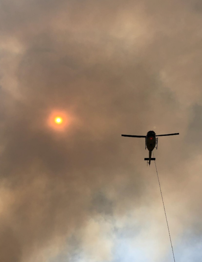
With the clearer air conditions, smoke is currently visible in a couple of areas on the #SlinkFire. The smoke is interior of the containment lines and multiple resources are still staffing it, including two helicopters. inciweb.nwcg.gov/incident/7105/

Some of the action on the #slinkfire @RenoFireDept E6 responded on immediate need two nights ago @RenoFirefighter @EFPFirefighters @TMFPD and others doing great work (pic courtesy of #TMFR Captain Scott Stephenson)


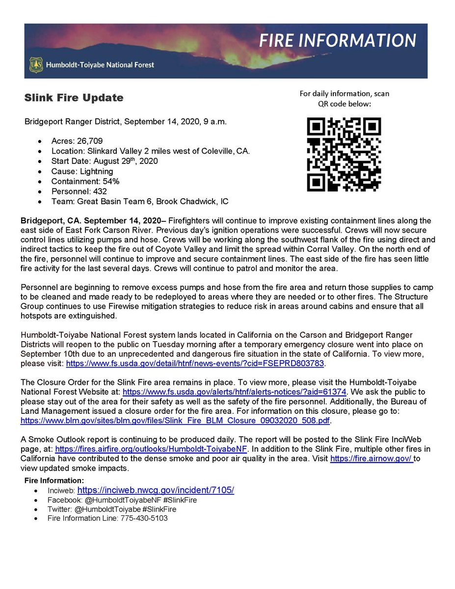
#UPDATE: The #SlinkFire west of Coleville has burned 26,709 acres and is 54 percent contained. STORY HERE: bit.ly/3khTrq5

Smoke is an interstate air pollution issue and should be managed as such. We need to manage wildfire smoke and prescribed fire smoke jointly to minimize health impacts. This afternoon, 300k population in Nevada are downwind from the #SlinkFire burning on USFS land in California.
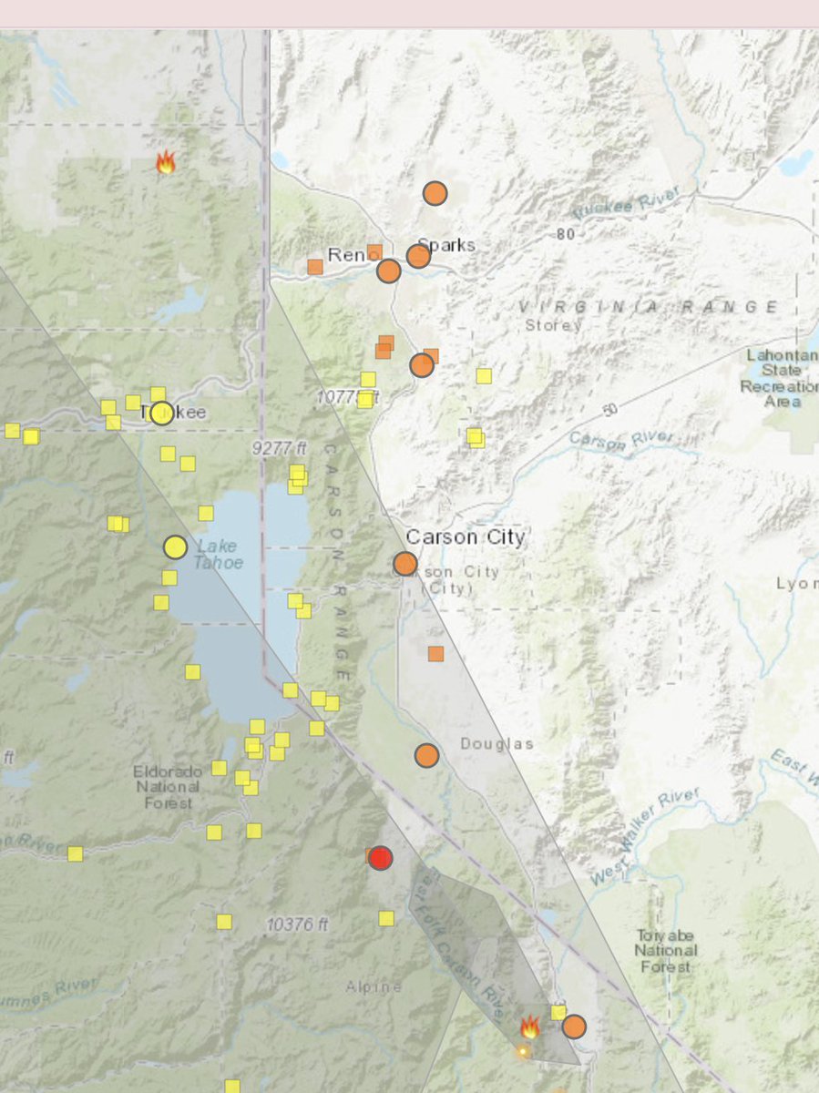
630 AM: Camera looking at the smoke plume and smoke filled areas from the #SlinkFire west of Hwy 395/the Antelope Valley. Air quality has also decreased in the Sierra Valley and Reno-Sparks area. For the latest air quality, bit.ly/oZY8K
The Slink Fire left Slinkard Valley yesterday and came over the hills to burn down toward Coleville last night. jeffsullivanphotography.com/blog/2020/08/3… #SlinkFire #California #wildfires #CaliforniaWildfires #StormHour


Another area of concern is the Iceberg Wilderness on the west side of the fire. Based on the easterly winds and low humidities, 👨🚒👩🚒 expect to continue to experience extreme fire behavior. #SlinkFire


Morning briefing on #SlinkFire. Numerous #TMFR Firefighters and resources supporting efforts to contain wildfire.


Smoke filling #LakeTahoe Basin again. #SlinkFire is closer but smoke from #NorthComplex continues to head to lake from the north. southtahoenow.com/story/08/30/20…

#SlinkFire update: Smoke is visible in the area, being produced by a large island within the fire perimeter. This area is expected to continue to create smoke but is surrounded by already burned and cold areas of the fire, effectively posing no threat to the containment line.

See below for very helpful info with the latest smoke forecast smoke forecast. Stay safe, everyone! #slinkfire
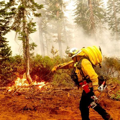
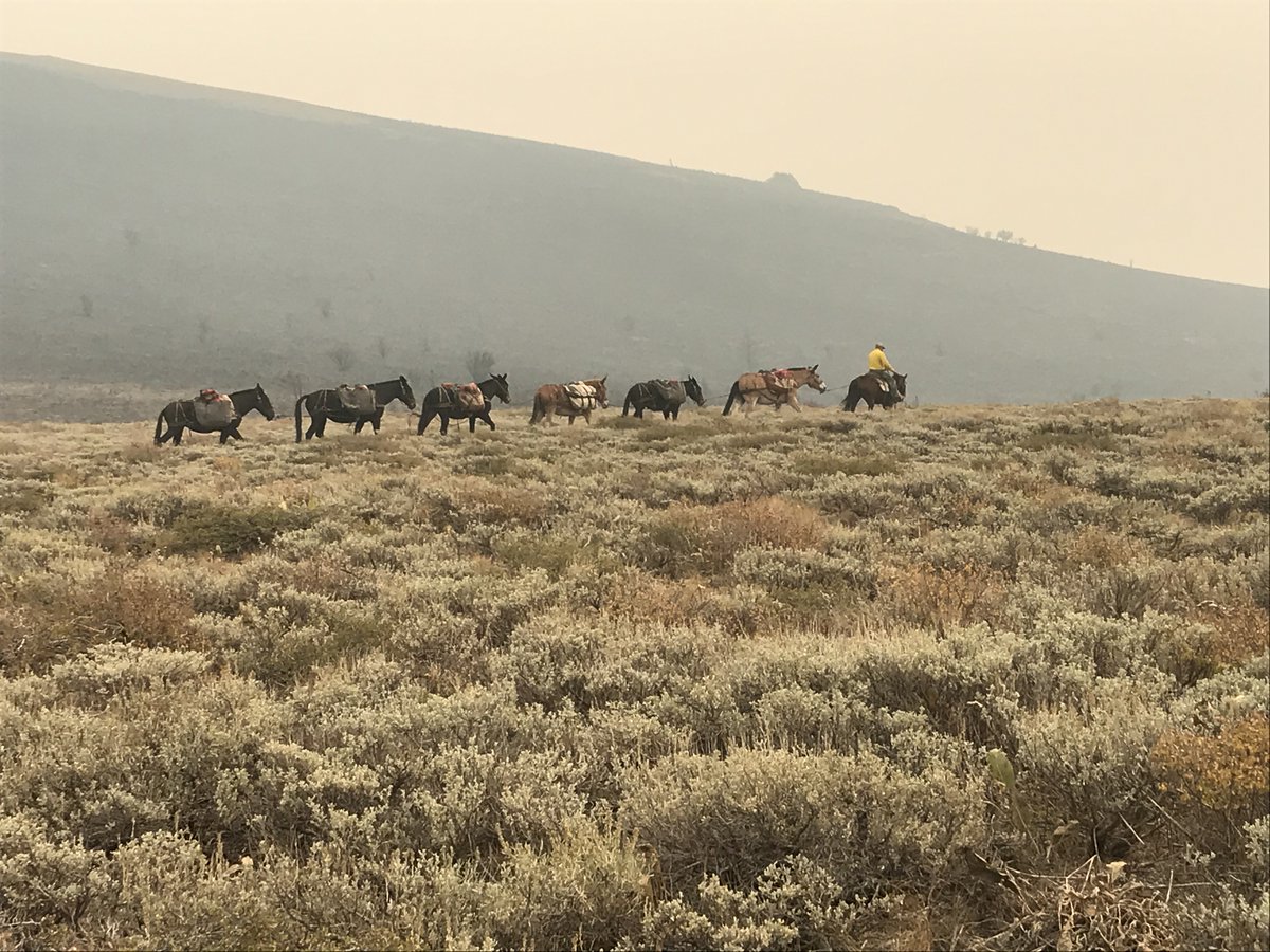
Using #mules to pack crew gear, food, and water into a remote spike camp for firefighters on the #SlinkFire #Firefighters #CaliforniaFires
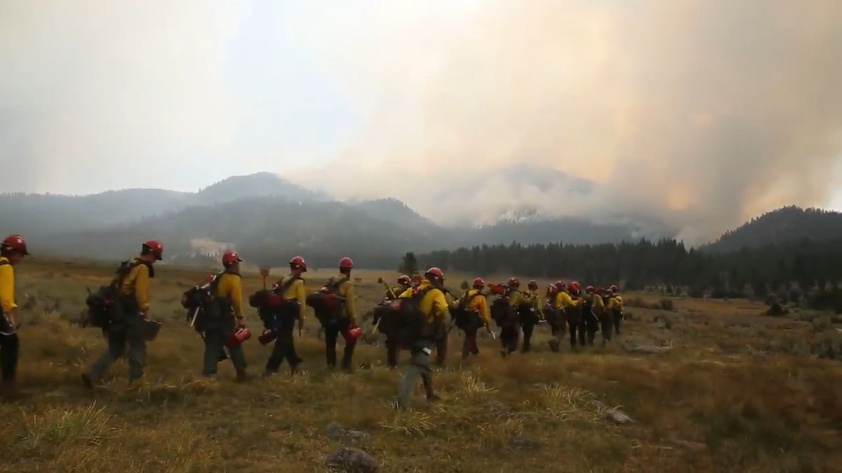
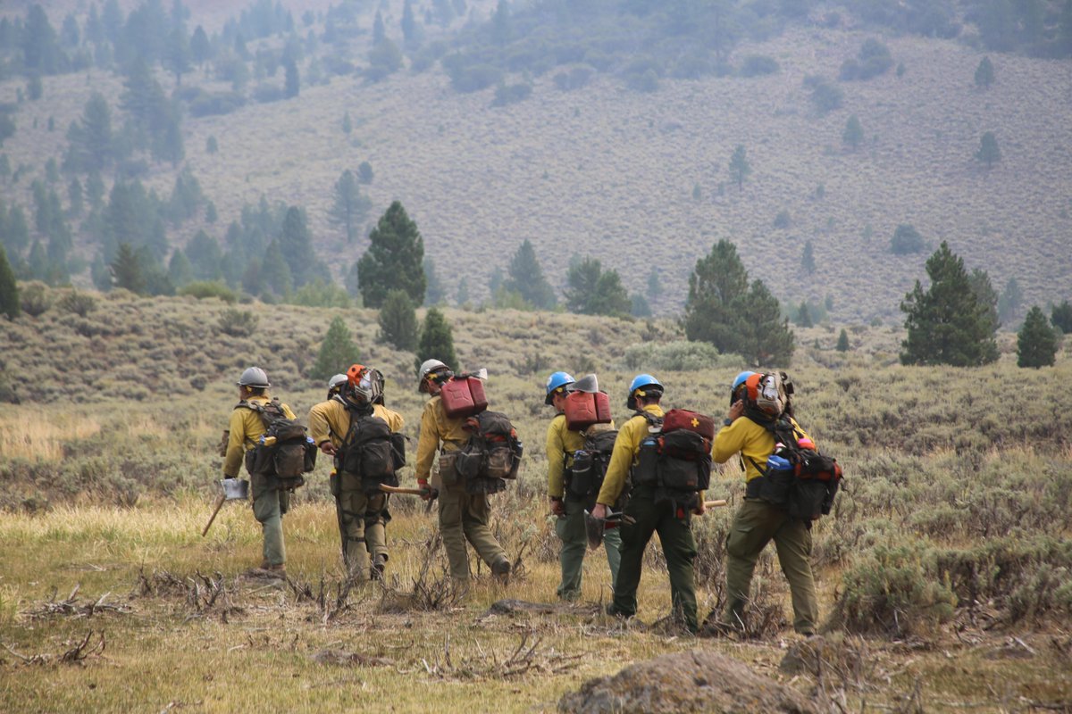
USDA Forest Service Wildland Firefighters from Engine 431 hike to the northwest side of the #SlinkFire in the @HumboldtToiyabe, three miles west of Coleville, Nevada. A total of almost 650 personnel continue working to suppress this fire, now at 36% containment.
Something went wrong.
Something went wrong.
United States Trends
- 1. Resident Evil N/A
- 2. Platner N/A
- 3. Maine N/A
- 4. Collins N/A
- 5. Janet Mills N/A
- 6. #BuschAppleSweepstakes N/A
- 7. JP Morgan N/A
- 8. Amex N/A
- 9. Tim Scott N/A
- 10. Good Thursday N/A
- 11. David Allan Coe N/A
- 12. Happy Friday Eve N/A
- 13. Calais Campbell N/A
- 14. Plume N/A
- 15. Scalise N/A
- 16. #MCMRodeadaPorLaMafia N/A
- 17. Weapons N/A
- 18. Wagaman N/A
- 19. Austin Abrams N/A
- 20. #ThursdayMotivation N/A