#cawx search results
Big changes coming later this week. Cool, moist and breezy through Tuesday, then a sharp warming and drying trend to follow. #cawx

#UPDATE: A tornado touched down Tuesday afternoon in Fresno County, CA. The tornado has been rated an EF-1. While tornadoes like these are rare, it's important to remember that they can still occur! #CAwx

Radar Update [1:55 PM] - Healdsburg is officially seeing rain! ☔️ Our wx spotters on the ground have confirmed showers moving through. Radar shows the North Bay is currently the target for RA, so keep those wipers on and take it slow on the roads. 🌧️🚙 #NorthBay #CAwx #Healdsburg
Sun 5/3/26 @ Noon PDT: Gusty winds will develop later this afternoon in the higher terrain adjacent to the western SJV, mainly in Kern and Kings Counties. This impacts areas mainly along I-5 & westward in these counties. #CAWx


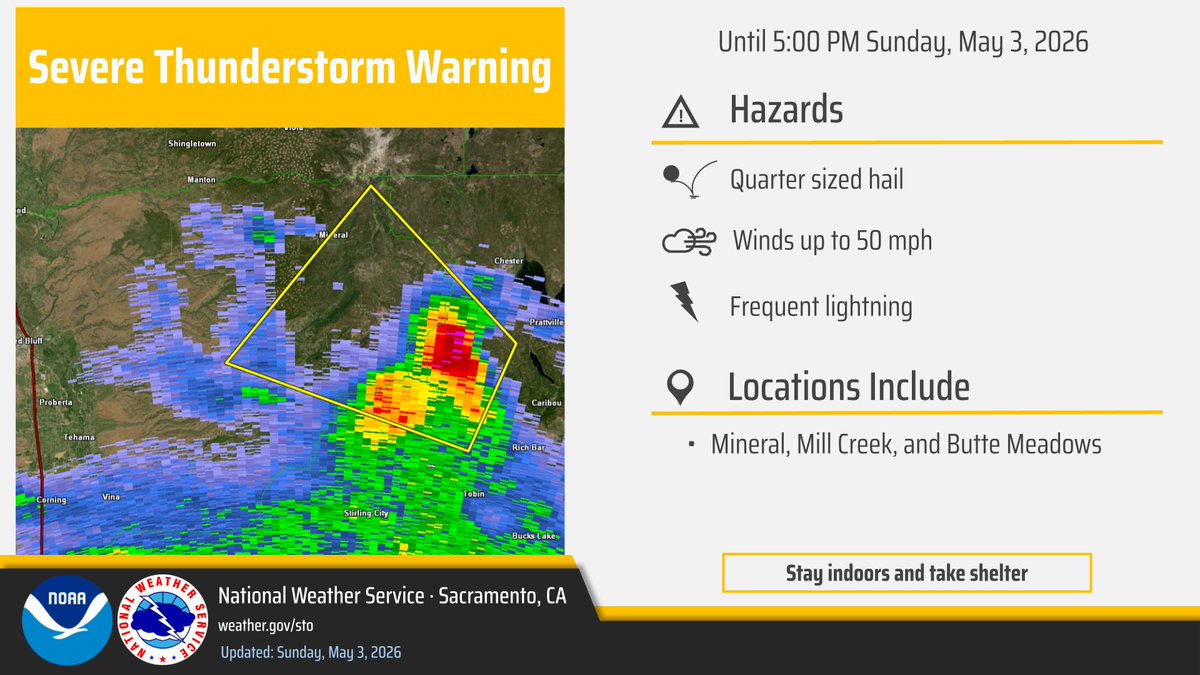
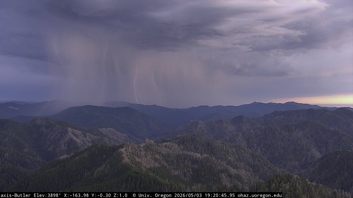
We've issued a Severe Thunderstorm Warning for a storm northwest of Caribou until 5:00 pm. Hazards include quarter sized hail, winds up to 50 mph, and frequent lightning. If you see a flash, dash inside! #CAwx
NEW: 🌪️Views from Tuesday as two tornadoes touched down yesterday afternoon in the Central Valley of California in the greater Fresno area. This system also brought multiple inches of rain to the Bay Area & some much needed snow to the parched Sierra Mountains. #CAwx
Drizzle and light rain chances return tonight through Tuesday morning. 🌧️ A drying trend begins Wednesday as high pressure builds, bringing warmer temps to the region through Friday. ☀️ #CAwx #BayAreaWX

🌧️Our radar is picking up on some drizzle from the San Mateo Peninsula down to Monterey Bay and over to the Santa Clara Valley. Are you seeing any drizzle where you are? #CAwx
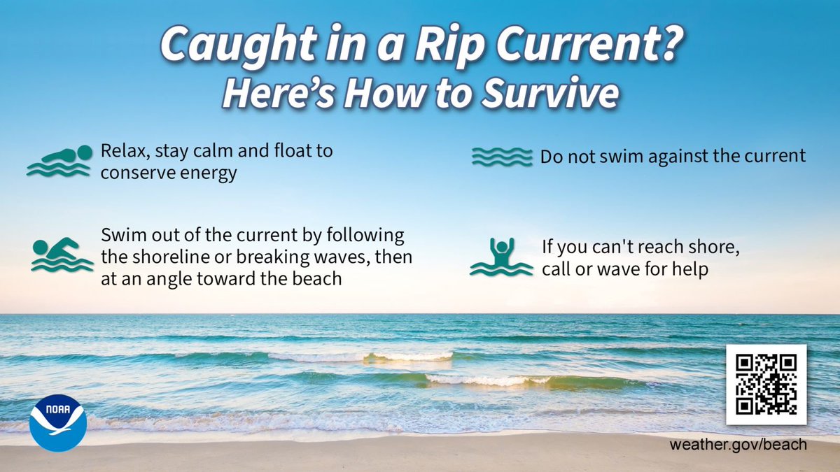
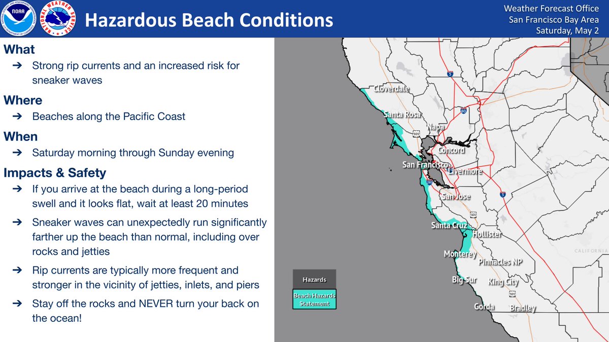
Got beach plans this weekend? Be sure to stay up to date on marine conditions! There is an increased risk for rip currents & sneaker waves Saturday morning to Sunday evening along the Pacific coastline beaches. Stay off the rocks & never turn your back on the ocean!🌊 #CAwx

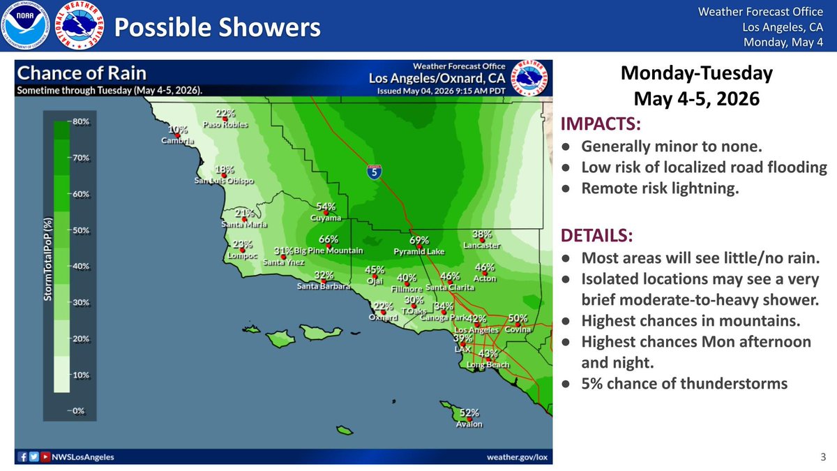
Rain showers will continue through Sunday, with some areas not even seeing any measurable rain. Impacts are expected to be minimal, if any, at this time. Another chance for rain comes mid-week. #SoCal #CaWx #CARain


Storm rolls in to Mammoth Mountains in the eastern Sierra #CAwx @jason61987 @realwxforecast @alpinemike13

🌧️Drizzle/light rain returns today! 🌧️ Scattered showers are set to move in this morning/afternoon and continue through Sunday. Precipitation totals continue to be light with the best chances for >0.10" still in the Santa Cruz Mountains and the Santa Lucia Range. #CAwx


🔴 SEVERE in the Sierra! Quarter-size hail pounding Downieville NOW — vehicles getting hammered! Moving NW at 30mph. La Porte, Little Grass Valley — TAKE COVER! #CAwx #SevereWeather #StormChaser
Highs today and for the weekend will be a little on the cool side. Expect a mix of sun and clouds today and Sunday with cloudier skies on Saturday. There's also an increased chance for light rain/drizzle along the Pacific coast this morning and the weekend. #CAwx

Breezy to locally windy conditions have developed this afternoon and will continue to increase, peaking later this evening. A Wind Advisory is in effect across western Imperial County from this evening through tomorrow morning where wind gusts above 40 mph are expected. #cawx


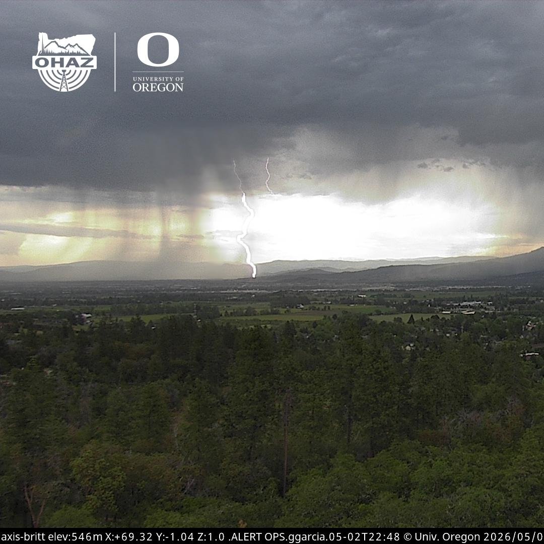
[Delayed Report] On May 3, at 3:15 PM PDT, 2 NW Quincy [Plumas Co, CA] Fire Dept/Rescue reports Tstm Wnd Dmg. Quincy Fire Department reported three downed trees associated with strong thunderstorms. Observed peak wind gusts were up to 45 mph. #cawx mesonet.agron.iastate.edu/lsr/?by=wfo&wf…
![iembot_sto's tweet image. [Delayed Report] On May 3, at 3:15 PM PDT, 2 NW Quincy [Plumas Co, CA] Fire Dept/Rescue reports Tstm Wnd Dmg. Quincy Fire Department reported three downed trees associated with strong thunderstorms. Observed peak wind gusts were up to 45 mph. #cawx mesonet.agron.iastate.edu/lsr/?by=wfo&wf…](https://pbs.twimg.com/media/HHfVtvoXMAAR-V6.jpg)
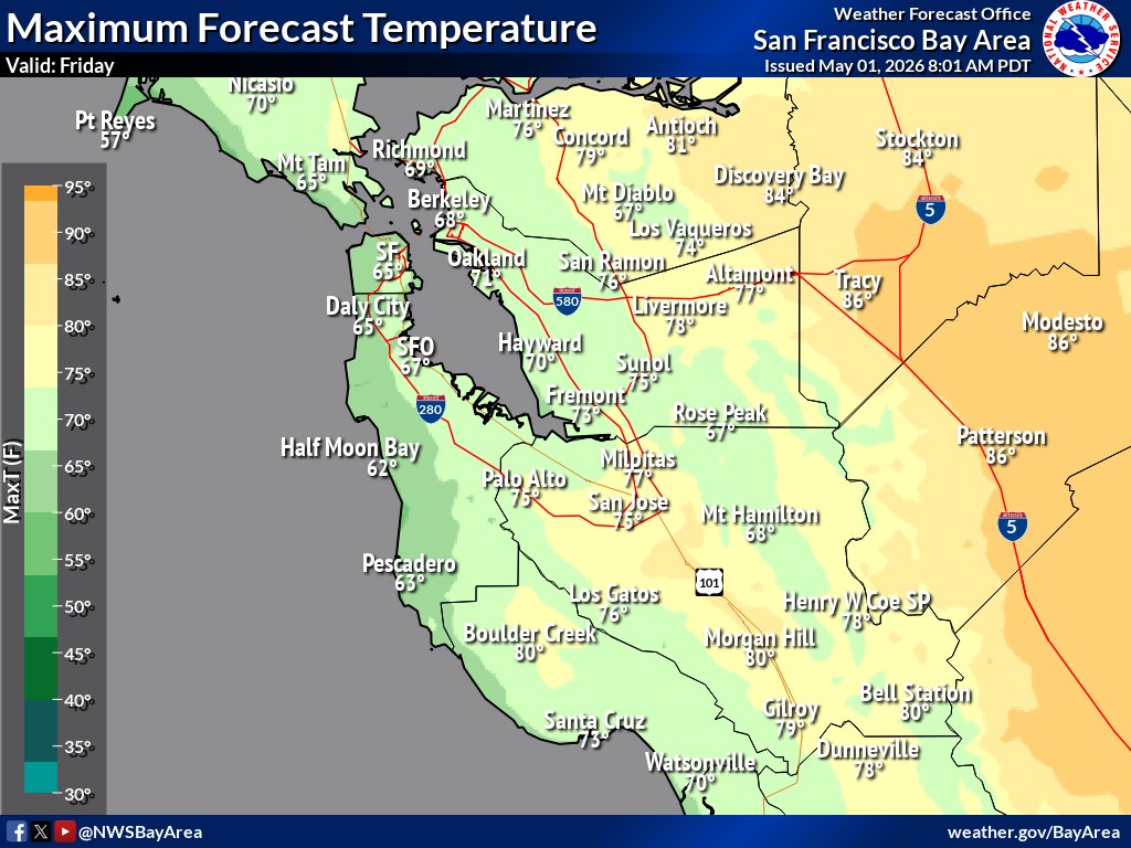
Enjoy the Friday afternoon sun! ☀️ Highs reach the 80s inland today before a weekend cooling trend. 📉 Changes arrive early next week as the weather turns unsettled with a chance of light rain/drizzle by Monday. ☁️🌦️ #CAwx #BayAreaWX


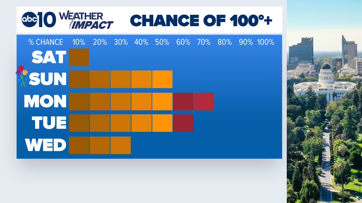
Could we hit the century mark with this upcoming heat? 💯 There's a chance! Best opportunities looking to be Monday and/or Tuesday. Something to watch. Let's see how the forecast develops over the next few days. #CAwx @ABC10

BIG BIG WARM UP COMING TO #CAWx 90s to upper 90s this week @foxweather @CraigHerreraTV

WEATHER ALERT: Be ready for some wet roads for AM commute! Tracking lightning on Sonoma Co. coast right now as seen on @LiveDoppler7 . Rain's starting to spread to other areas tonight. #SanFrancisco #BayArea #CAwx #StormWatch
RAIN TIMELINE: It's raining across parts of north bay right now! @LiveDoppler7 tracking active weather across parts of California. Rain spreads later tonight & continues through AM. #StormWatch #SanFrancisco #BayArea #CAwx #forecast
Could we hit the century mark with this upcoming heat? 💯 There's a chance! Best opportunities looking to be Monday and/or Tuesday. Something to watch. Let's see how the forecast develops over the next few days. #CAwx @ABC10
A soggy start to the workweek, but it's not going to stay that way! Big time warming is on the way for the Mother's Day weekend! Highs in the 80s to end the workweek, then 90s over the weekend, 95°+ looking likely to start next week! #CAwx @ABC10
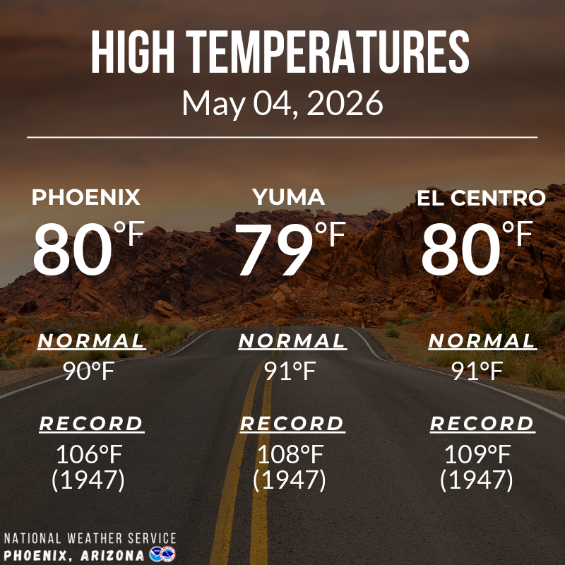
Temperatures remained well below normal today thanks to abundant cloud cover. In fact, the high at Sky Harbor actually occurred just after midnight. Afternoon readings around the metro had a hard time getting out of the 70s. #azwx #cawx

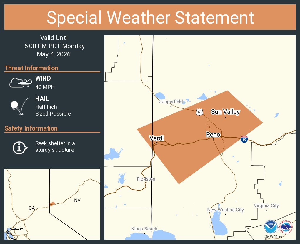
A special weather statement has been issued for Reno NV, Sparks NV and Sun Valley NV until 6:00 PM PDT #CAwx #NVwx
Storm rolls in to Mammoth Mountains in the eastern Sierra #CAwx @jason61987 @realwxforecast @alpinemike13
A special weather statement has been issued for Portola CA, Graeagle CA and Delleker CA until 4:30 PM PDT #CAwx


N. Ops🔥 Humidity in the teens by the weekend. Breezy north winds Sat. = elevated fire weather conditions in Sacramento Valley. Gusts between 15 and 25 mph. Next week, models hinting at the potential for triple digit temperatures as ridging amplifies over the region. #cawx

Hitting here in Petaluma now too. ☔️ #CAwx
Radar Update [1:55 PM] - Healdsburg is officially seeing rain! ☔️ Our wx spotters on the ground have confirmed showers moving through. Radar shows the North Bay is currently the target for RA, so keep those wipers on and take it slow on the roads. 🌧️🚙 #NorthBay #CAwx #Healdsburg


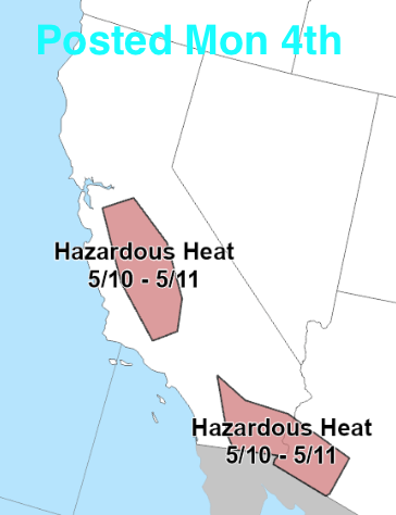
Triple-digit heat is likely for parts of California and the Southwest late this weekend into next week, with highs potentially reaching 110 degrees F in the Desert Southwest, and 100 to 105 degrees F in southern sections of the Central Valley of CA.


Radar Update [1:55 PM] - Healdsburg is officially seeing rain! ☔️ Our wx spotters on the ground have confirmed showers moving through. Radar shows the North Bay is currently the target for RA, so keep those wipers on and take it slow on the roads. 🌧️🚙 #NorthBay #CAwx #Healdsburg

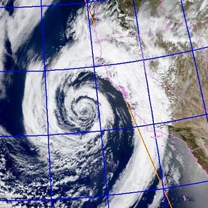
HRRR Model's Simulated Radar depiction through the next 30hrs - A Low Pressure System will move across #SoCal tonight bringing more clouds, cooler weather and chance for a few showers later today through mid-day Tuesday. #CAwx
Big changes coming later this week. Cool, moist and breezy through Tuesday, then a sharp warming and drying trend to follow. #cawx
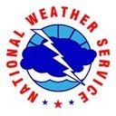
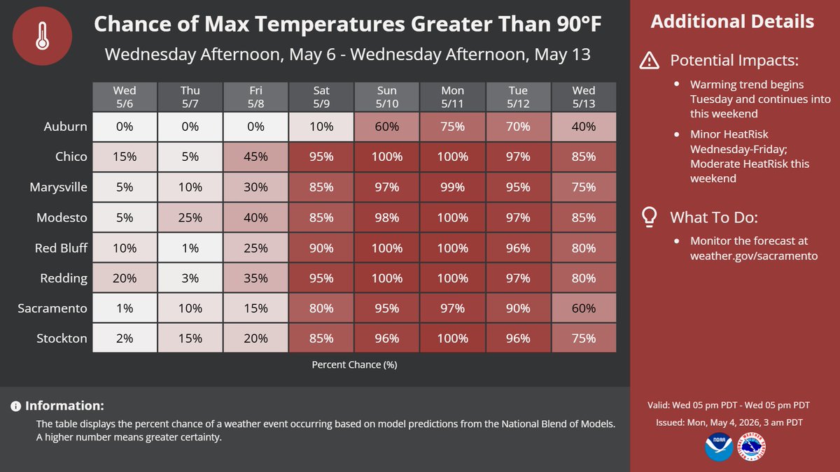
Above-normal high temperatures are in the forecast later this week. Here are the latest probabilities of reaching at least 90°F later this week into the middle of next week. #CAwx

An isolated shower or two is possible today. Sprinkles are more likely. Showers likely tomorrow morning. Skies clear and temperatures warm up fast starting on Wednesday. Highs will be above normal Thursday with gusty winds on Friday. Triple digit heat possible on Sunday. #cawx

Fire crews responded to a Los Angeles County vegetation fire on Sunday. Conditions remain dry out west, but this week's next push of moisture could help! #CAwx
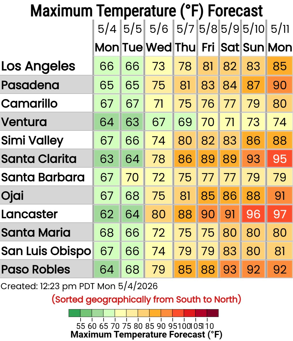
Temperatures will begin to warm up later this week and into the weekend. Here's a look at the chance of temperatures getting above 90F this week. Stay hydrated and limit time outdoors during the warmest parts of the day. #CAWx


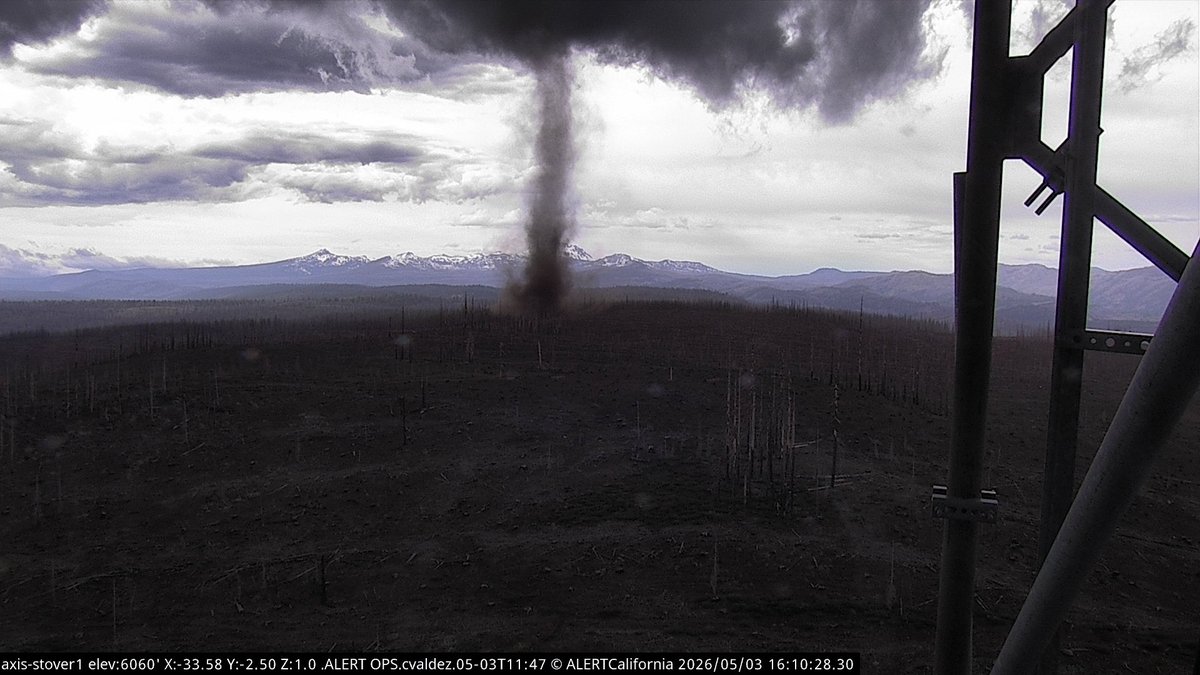
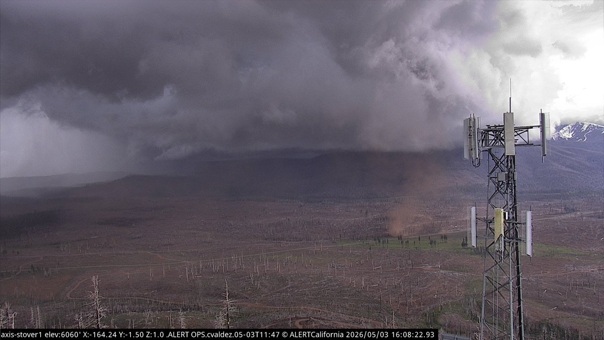
Just had an insane landspout (gustnado?) near Chester, CA! #cawx @RobMayeda @NWSSacramento @ALERTCalifornia

Big changes coming later this week. Cool, moist and breezy through Tuesday, then a sharp warming and drying trend to follow. #cawx
Due to abundant cloud cover, low temperatures were above normal across the lower deserts this morning. Phoenix had a low of 74 degrees which ties the record warm low for today's date. #azwx #cawx

A special weather statement has been issued for Reno NV, Sparks NV and Sun Valley NV until 6:00 PM PDT #CAwx #NVwx
Above-normal high temperatures are in the forecast later this week. Here are the latest probabilities of reaching at least 90°F later this week into the middle of next week. #CAwx
Temperatures remained well below normal today thanks to abundant cloud cover. In fact, the high at Sky Harbor actually occurred just after midnight. Afternoon readings around the metro had a hard time getting out of the 70s. #azwx #cawx
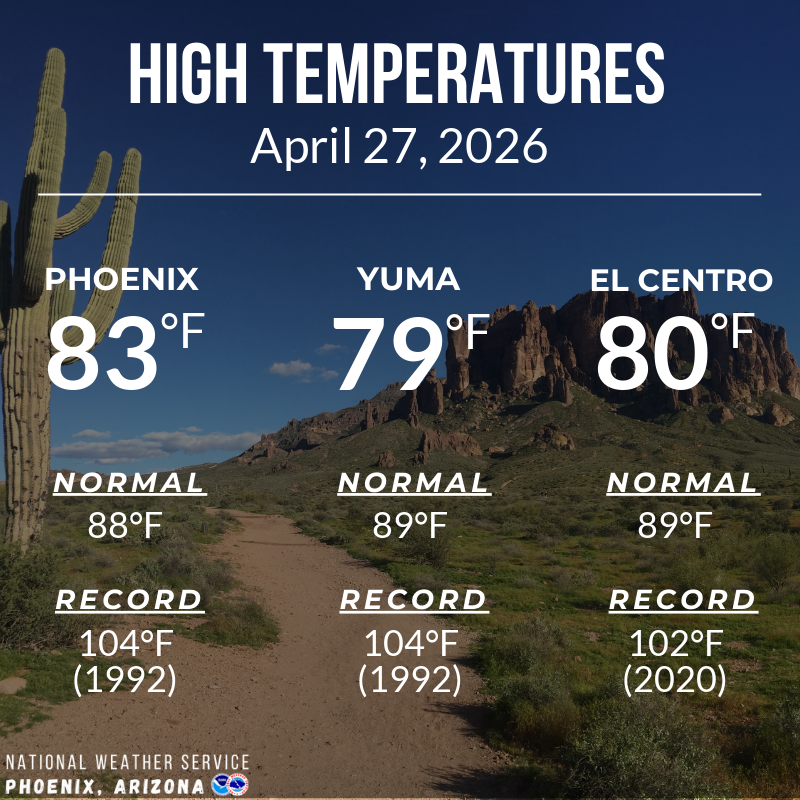
Phoenix, Yuma, and El Centro recorded highs that were several degrees below normal this afternoon, topping out in the upper 70s to lower 80s. Temperatures will warm closer to average beginning tomorrow. #azwx #cawx
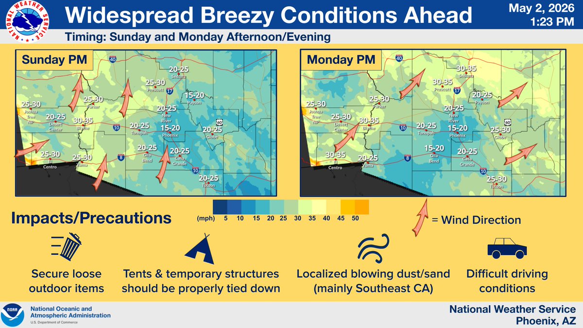
A low pressure system will approach the region late this weekend/early next week, leading widespread breezy conditions to develop. PM gusts will peak between 20-35 mph. Difficult driving conditions are possible along I-8 & I-10 w/ southerly crosswinds, especially Sun. #azwx #cawx
Much cooler temperatures with lower desert highs reaching the lower 80s are expected today under mostly cloudy skies. #azwx #cawx

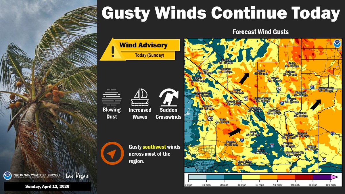
Gusty southwest winds continue today with widespread gusts of 30-50 mph. A Wind Advisory is in effect for most of the area until this evening. Sudden crosswinds, blowing dust, and hazardous boating conditions are all possible. #nvwx #cawx #azwx
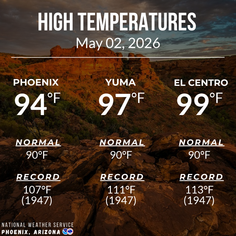
Highs this afternoon across lower desert areas ranged from the mid to upper 90s, with our three main climate sites sitting between 4-9 degrees above normal for the start of May. Similar readings can be expected for Sunday. #azwx #cawx
Heading to the beach this weekend? A Beach Hazards Statement goes into effect at 11AM today and remains in effect through Sunday evening due to an increased risk of sneaker waves and rip currents. Stay aware of marine conditions and never turn your back on the ocean. #CAwx
A Wind Advisory has been issued for much of the area from this afternoon through Sunday due to southwest winds 25 to 35 mph with gusts to 50 mph. Use extra caution while driving or boating. Areas of lower visibility due to blowing dust will be possible. #nvwx #azwx #cawx

⛈️ Today's (5/4) T-Storm Outlook: We're expecting another round of showers & t-storms today, mainly in the 11 am to 8 pm window. Strong winds/blowing dust, small hail, lightning, sudden temp drops & brief heavy rain are among potential hazards with today's storms. #cawx #nvwx

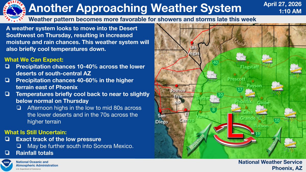
Another weather system looks to move through the region on Thursday. This system will briefly cool temperatures back down to near to slightly below normal and bring increased chances for showers and isolated/scattered thunderstorms. Stay tuned for updates! #azwx #cawx
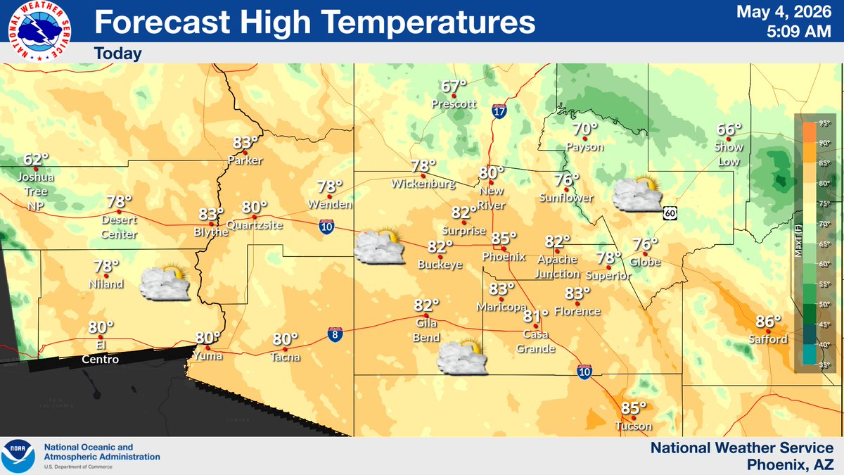
Morning low temperatures were almost exactly at their daily normals under mostly clear skies. Look for increasing high clouds today w/ afternoon highs in the upper 80s to lower 90s. Locally gusty winds & lofted dust are possible this evening. #azwx #cawx

Interested in severe weather? Live in South-Central AZ, Southwest AZ, or Southeast CA? Two virtual Skywarn spotter training sessions will be held in May! Stay safe during the monsoon season & help us keep others safe. Register here: weather.gov/psr/skywarn.ht… #azwx #cawx


Something went wrong.
Something went wrong.
United States Trends
- 1. Wemby N/A
- 2. #MetGala N/A
- 3. #WWERaw N/A
- 4. Mike Conley N/A
- 5. Anthony Edwards N/A
- 6. Knicks N/A
- 7. #bucciovertimechallenge N/A
- 8. Michael Conforto N/A
- 9. Pagan N/A
- 10. Keldon Johnson N/A
- 11. Spurs N/A
- 12. Brunson N/A
- 13. Julius Randle N/A
- 14. Dylan Harper N/A
- 15. De'Aaron Fox N/A
- 16. #TheRookie N/A
- 17. Taylor Hall N/A
- 18. Castle N/A
- 19. Davis Martin N/A
- 20. Victor Wembanyama N/A