#mappingdrones результаты поиска


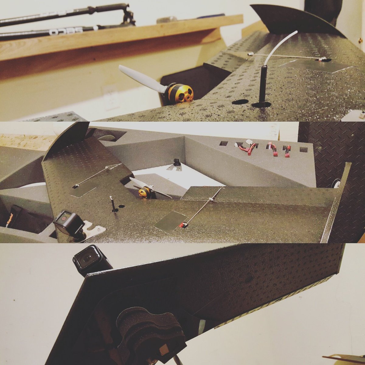
First off the assembly line! Custom dual gopro mapping drone. #customdrones #mappingdrones #drones #suasnews

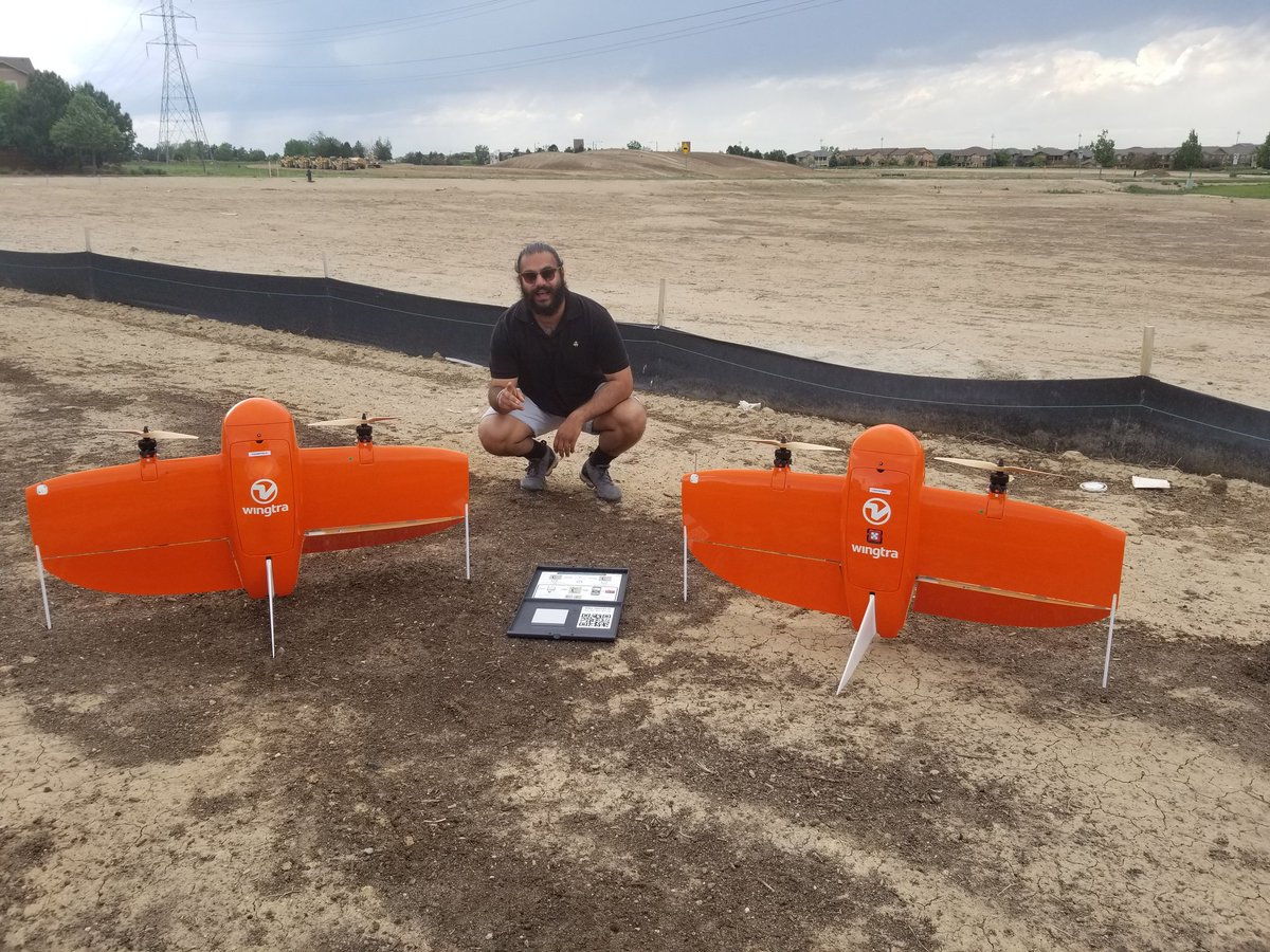
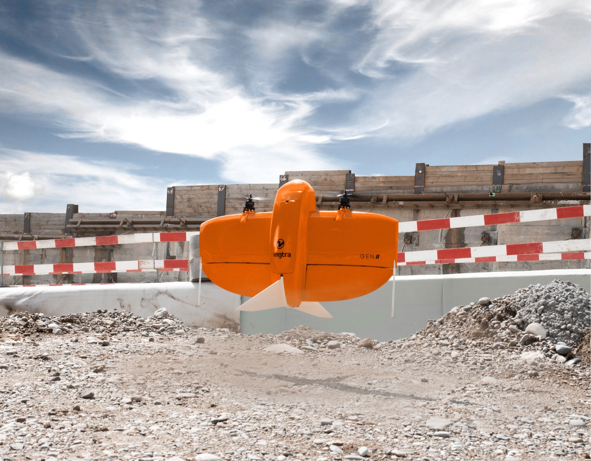
Vertical Takeoff And Landing = best of both worlds. Its lighter than it looks untill you add two batteries and some awsome payloads. #wingrta #mappingdrones #flylikeabird

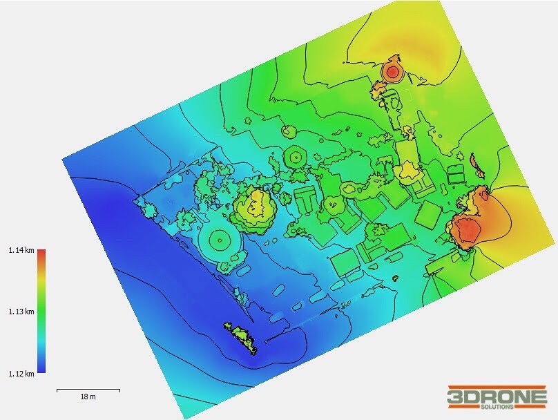
Fazemos o modelo digital de elevação (MDE) de sua terra ou trabalho. Nós podemos fazer MDS ou MDT e linhas de contorno de acordo com suas necessidades. #mappingdrones #mapeamentodrone #drones #topografia #modelado3d #med

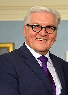
We were delighted to discuss #mappingdrones with the President of Germany Frank-Walter Steinmeier while presenting our hybrid VTOL drone, #Marlyn, at @yesdelft @AuswaertigesAmt

Day 2 @GEOBusinessShow, now with Skeye, a formidable Dutch UAS Services company that has successfully pulled Shell onto its books. #geobusiness2018 #surveydrones #mappingdrones

The SME Mine Exchange is just over a month away. We hope to see you there and share how you can collect data over large areas. #MineXchange @smecommunity #mappingdrones #dronesatwork #mining


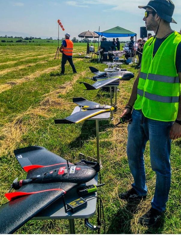
Check out Martin Iliev of Bulgaria using senseFly’s industry-leading fixed-wing drones to collect spatial data in the village of Gorni Lozen. lnkd.in/egVvRac #drones #fixedwing #mappingdrones
Mapeamento e Topografia com drone. Deixe-nos ajudá-lo é o seu projeto e conte um produto inovador e de alta qualidade. #mappingdrones #mapeamentodrone #topografiadrone #drone #DJI… instagram.com/p/Bl_k94dltuj/…
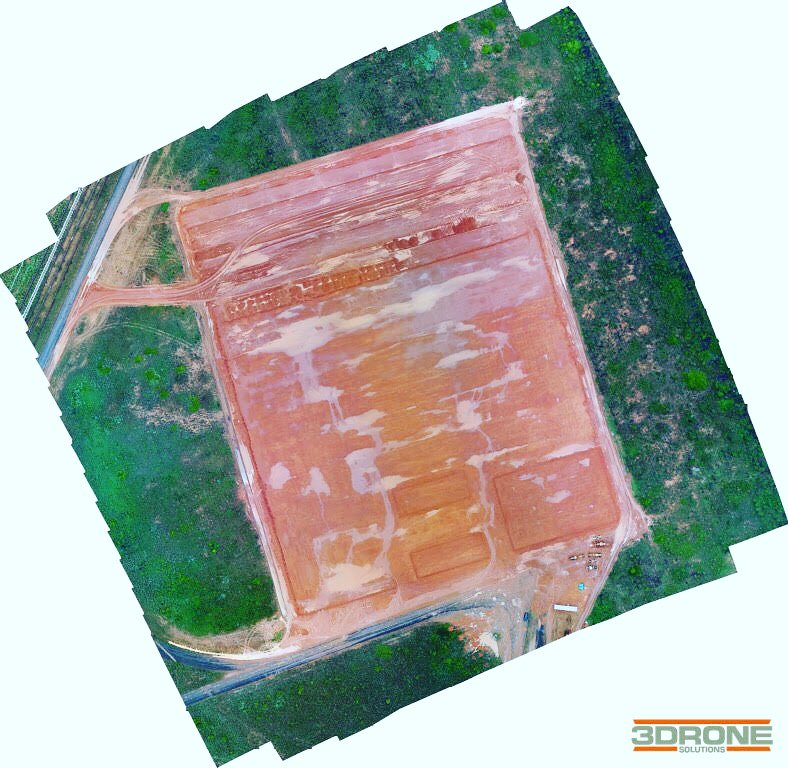
Realizamos modelagem 3D do seu obra ou terreno. Fale conosco #mappingdrones #mapeamentodrone #3d #modelado3d #topografiadrone #topografia #fotodrone #phantom4pro #engenharia instagram.com/p/BmHWH6Rl8A0/…

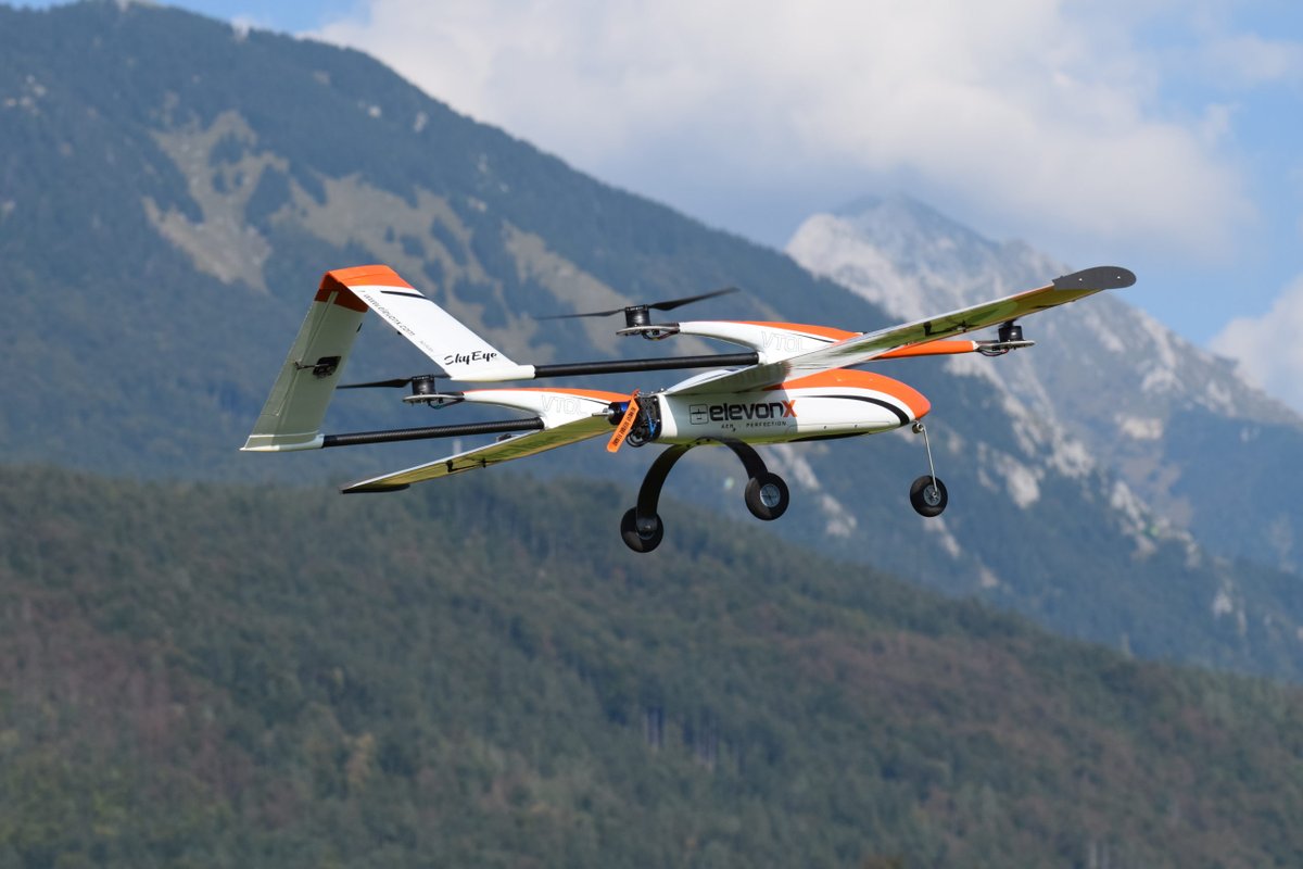
SkyEye Sierra VTOL – Unmanned Aerial Vehicle–Mapping to Surveillance Missions: · It can carry up to 3 kg of payload. Range (at Cruise) 320 KM = 198.84 miles .Endurance (at Cruise) 3 hrs. Electric – 5 hrs. Gas. ozrobotics.com/shop/vtol/?ref… . #drones #mappingdrones #militarydrones #UAV
Realizamos modelagem 3D do seu obra ou terreno. Acompanhamento e monitoramento de sua construção. Precisão e confiança #mappingdrones #mapeamentodrone #3d #modelado3d #topografiadrone #topografia #fotodrone #phantom4pro #engenharia #drones #saocarlos instagram.com/p/BmHWH6Rl8A0/…


Land surveying made simple! #VTOL #mappingdrones
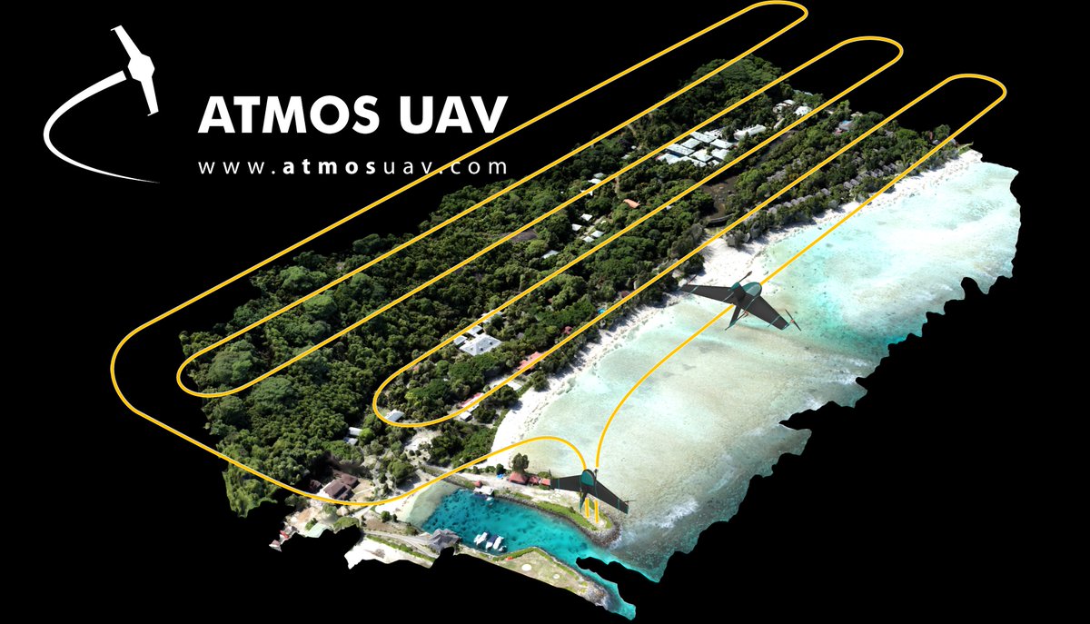
Generate your flight plan easily and intuitively with Marlynk planning software. Find out more at atmosuav.com/product/howitw… #mapping #geospatial
The Trinity with the @Sony 42mp sensor can help get your job done quicker. You can easily cover 1000 acres in an hour or 1700 in 90 minutes. Under a week away, come find us. #MineXchange @smecommunity #mappingdrones #dronesatwork #mining zcu.io/XQHO


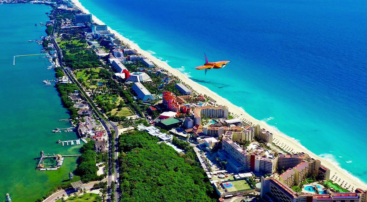
If you ever wondered how #mappingdrones are changing the way we survey the planet, this story is for you. Read it to learn how surveyors mapped the entirety of Cancún down to 5 cm (2 in) for #cadastral analysis using #WingtraOne in 19 days flight time😮👏: hubs.la/H0H7HTK0

Efficiency is crucial when it comes to solar energy and by using senseFly it allows any anomalies in the panels to be identified and addressed quickly. #mappingdrones #workingdrones bit.ly/2pVl6qi

Customized Drones™, a renowned drone manufacturing team based in Dubai, is proud to introduce advanced mapping drones in South Africa, featuring a myriad of customizable features. More details: c-drones.com/shop/uav-mappi… #mappingdrones #dronetech #nextgendrone

The technology in a senseFly drone is amazing and will change the way you map forever, but you'll need to learn how to launch and land properly. #sensefly #mappingdrones waypoint.sensefly.com/mapping-drone-…
Need to collect high density lidar over large areas? The Tron combined with the @YellowScan Surveyor Ultra has you covered. Up to 3700 acres in a single flight. Just 10 days away. #MineXchange @smecommunity #mappingdrones #dronesatwork #mining zcu.io/U7HN

Customized Drones™, a renowned drone manufacturing team based in Dubai, is proud to introduce advanced mapping drones in South Africa, featuring a myriad of customizable features. More details: c-drones.com/shop/uav-mappi… #mappingdrones #dronetech #nextgendrone
Mapping drones are transforming the game, enabling precise data collection for diverse industries. Check out this list of top mapping drones for 2023 and elevate your geospatial projects! 🗺️🛰️ linkedin.com/feed/update/ur… #MappingDrones #Geospatial #AerialMapping


Mapping drone startup Wingtra is charting a new future after landing $22M techcrunch.com/2023/03/21/win… #MappingDrones #IoTstartups #IoTFunding
If you ever wondered how #mappingdrones are changing the way we survey the planet, this story is for you. Read it to learn how surveyors mapped the entirety of Cancún down to 5 cm (2 in) for #cadastral analysis using #WingtraOne in 19 days flight time😮👏: hubs.la/H0H7HTK0
The Trinity with the @Sony 42mp sensor can help get your job done quicker. You can easily cover 1000 acres in an hour or 1700 in 90 minutes. Under a week away, come find us. #MineXchange @smecommunity #mappingdrones #dronesatwork #mining zcu.io/XQHO
Need to collect high density lidar over large areas? The Tron combined with the @YellowScan Surveyor Ultra has you covered. Up to 3700 acres in a single flight. Just 10 days away. #MineXchange @smecommunity #mappingdrones #dronesatwork #mining zcu.io/U7HN
The technology in a senseFly drone is amazing and will change the way you map forever, but you'll need to learn how to launch and land properly. #sensefly #mappingdrones waypoint.sensefly.com/mapping-drone-…
The SME Mine Exchange is just over a month away. We hope to see you there and share how you can collect data over large areas. #MineXchange @smecommunity #mappingdrones #dronesatwork #mining
Whether you're surveying or mapping, a proper takeoff and landing are crucial to all aerial projects. @sensefly has some great advice to make your flights run as smooth as possible. #workingdrones #mappingdrones waypoint.sensefly.com/tips-for-a-suc…
The eBee X allows for such high-quality mapping and surveying, that it was able to supply data that would have never been found on the prehistoric Anasazi Pueblo in New Mexico which dates back to the 5th century. #mappingdrones #UAV bit.ly/2Yj2M7h
Efficiency is crucial when it comes to solar energy and by using senseFly it allows any anomalies in the panels to be identified and addressed quickly. #mappingdrones #workingdrones bit.ly/2pVl6qi

First off the assembly line! Custom dual gopro mapping drone. #customdrones #mappingdrones #drones #suasnews
The SME Mine Exchange is just over a month away. We hope to see you there and share how you can collect data over large areas. #MineXchange @smecommunity #mappingdrones #dronesatwork #mining
Vertical Takeoff And Landing = best of both worlds. Its lighter than it looks untill you add two batteries and some awsome payloads. #wingrta #mappingdrones #flylikeabird
The Trinity with the @Sony 42mp sensor can help get your job done quicker. You can easily cover 1000 acres in an hour or 1700 in 90 minutes. Under a week away, come find us. #MineXchange @smecommunity #mappingdrones #dronesatwork #mining zcu.io/XQHO
Check out Martin Iliev of Bulgaria using senseFly’s industry-leading fixed-wing drones to collect spatial data in the village of Gorni Lozen. lnkd.in/egVvRac #drones #fixedwing #mappingdrones
We were delighted to discuss #mappingdrones with the President of Germany Frank-Walter Steinmeier while presenting our hybrid VTOL drone, #Marlyn, at @yesdelft @AuswaertigesAmt
Fazemos o modelo digital de elevação (MDE) de sua terra ou trabalho. Nós podemos fazer MDS ou MDT e linhas de contorno de acordo com suas necessidades. #mappingdrones #mapeamentodrone #drones #topografia #modelado3d #med
Mapeamento e Topografia com drone. Deixe-nos ajudá-lo é o seu projeto e conte um produto inovador e de alta qualidade. #mappingdrones #mapeamentodrone #topografiadrone #drone #DJI… instagram.com/p/Bl_k94dltuj/…
Need to collect high density lidar over large areas? The Tron combined with the @YellowScan Surveyor Ultra has you covered. Up to 3700 acres in a single flight. Just 10 days away. #MineXchange @smecommunity #mappingdrones #dronesatwork #mining zcu.io/U7HN
SkyEye Sierra VTOL – Unmanned Aerial Vehicle–Mapping to Surveillance Missions: · It can carry up to 3 kg of payload. Range (at Cruise) 320 KM = 198.84 miles .Endurance (at Cruise) 3 hrs. Electric – 5 hrs. Gas. ozrobotics.com/shop/vtol/?ref… . #drones #mappingdrones #militarydrones #UAV
Realizamos modelagem 3D do seu obra ou terreno. Fale conosco #mappingdrones #mapeamentodrone #3d #modelado3d #topografiadrone #topografia #fotodrone #phantom4pro #engenharia instagram.com/p/BmHWH6Rl8A0/…
Realizamos modelagem 3D do seu obra ou terreno. Acompanhamento e monitoramento de sua construção. Precisão e confiança #mappingdrones #mapeamentodrone #3d #modelado3d #topografiadrone #topografia #fotodrone #phantom4pro #engenharia #drones #saocarlos instagram.com/p/BmHWH6Rl8A0/…
If you ever wondered how #mappingdrones are changing the way we survey the planet, this story is for you. Read it to learn how surveyors mapped the entirety of Cancún down to 5 cm (2 in) for #cadastral analysis using #WingtraOne in 19 days flight time😮👏: hubs.la/H0H7HTK0
Customized Drones™, a renowned drone manufacturing team based in Dubai, is proud to introduce advanced mapping drones in South Africa, featuring a myriad of customizable features. More details: c-drones.com/shop/uav-mappi… #mappingdrones #dronetech #nextgendrone
Something went wrong.
Something went wrong.
United States Trends
- 1. Spotify 1.09M posts
- 2. Chris Paul 29.9K posts
- 3. Clippers 42.5K posts
- 4. Hartline 10.5K posts
- 5. Henry Cuellar 6,004 posts
- 6. #HappyBirthdayJin 104K posts
- 7. ethan hawke 4,316 posts
- 8. GreetEat Corp 1,169 posts
- 9. David Corenswet 7,342 posts
- 10. Jonathan Bailey 8,526 posts
- 11. South Florida 6,224 posts
- 12. Ty Lue 1,705 posts
- 13. Apple Music 249K posts
- 14. #NSD26 25.4K posts
- 15. Chris Henry 2,292 posts
- 16. Klein 16.6K posts
- 17. Adam Sandler 4,921 posts
- 18. Nashville 33.7K posts
- 19. #JINDAY 82K posts
- 20. #OurSuperMoonJin 82K posts