#ohwx search results
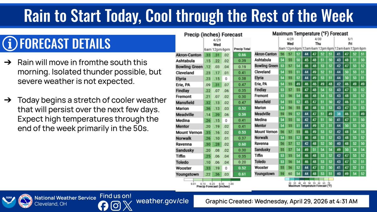
Damp start to the day, and beginning a cool trend. 50s for the next few days, and possible frost/freeze issues for the end of the week and into the weekend! #ohwx #pawx

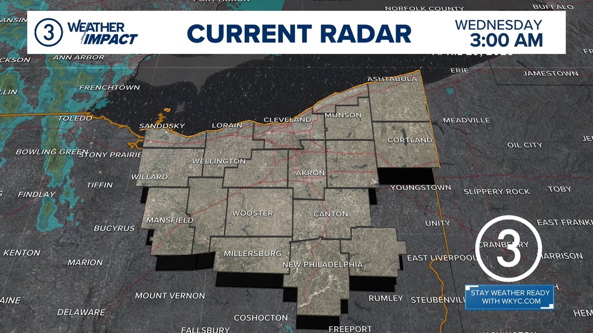
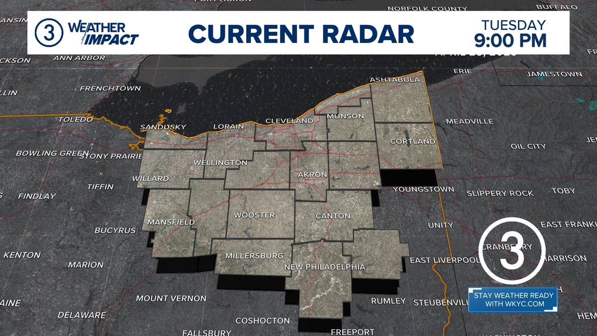
WEATHER IMPACT | Here's a quick check of the radar. Get more weather on the 3News App or at wkyc.com/weather from @wkyc #3weather #ohwx

There is a Slight Risk of severe thunderstorms today across the Lower Great Lakes & OH Valley. Damaging winds & a few tornadoes are possible this afternoon into early evening. #OHwx #MIwx #PAwx #NYwx

At 12:55 AM EDT, 2 SSE Choctaw Lake [Madison Co, OH] AWOS reports Non-Tstm Wnd Gst of M59 MPH. AWOS station KUYF Madison County Airport. #ohwx mesonet.agron.iastate.edu/lsr/?by=wfo&wf…
![ds_wx03's tweet image. At 12:55 AM EDT, 2 SSE Choctaw Lake [Madison Co, OH] AWOS reports Non-Tstm Wnd Gst of M59 MPH. AWOS station KUYF Madison County Airport. #ohwx mesonet.agron.iastate.edu/lsr/?by=wfo&wf…](https://pbs.twimg.com/media/HG95xdjXEAApuMC.jpg)

📌Take Note! Getting COOLER with RAIN & STORM CHANCES soon to return . . .take a listen on how it will impact our WINNING @Reds!! @Local12 #kywx #INwx #ohwx

[Delayed Report] On Apr 28, at 1:40 AM EDT, 1 ESE Corwin [Warren Co, OH] NWS Employee reports Tstm Wnd Dmg. Tree fell on US73 blocking westbound lane. Time estimated from RADAR. #ohwx mesonet.agron.iastate.edu/lsr/?by=wfo&wf…
![wxenthus's tweet image. [Delayed Report] On Apr 28, at 1:40 AM EDT, 1 ESE Corwin [Warren Co, OH] NWS Employee reports Tstm Wnd Dmg. Tree fell on US73 blocking westbound lane. Time estimated from RADAR. #ohwx mesonet.agron.iastate.edu/lsr/?by=wfo&wf…](https://pbs.twimg.com/media/HHBArpIXIAAkK4x.jpg)

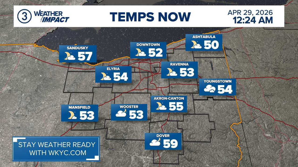
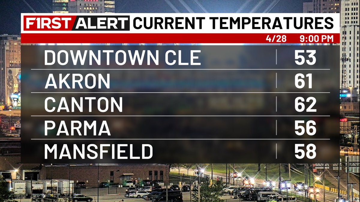
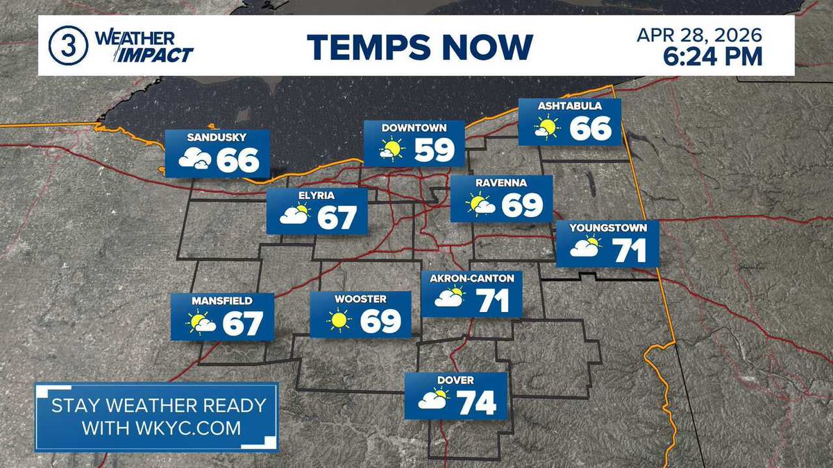
WEATHER IMPACT | Here's a look at the current weather and temperatures. Get your forecast anytime on the 3News App from @wkyc #3weather #ohwx
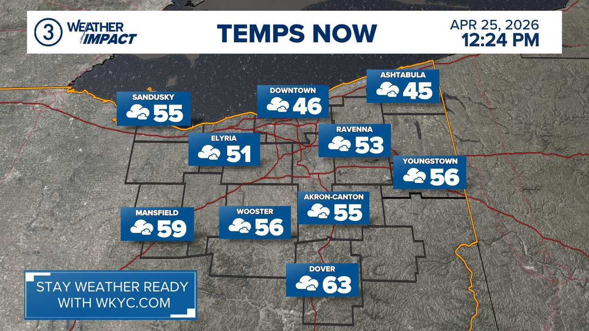
WEATHER IMPACT | Here's a look at the current weather and temperatures. Get your forecast anytime on the 3News App from @wkyc #3weather #ohwx
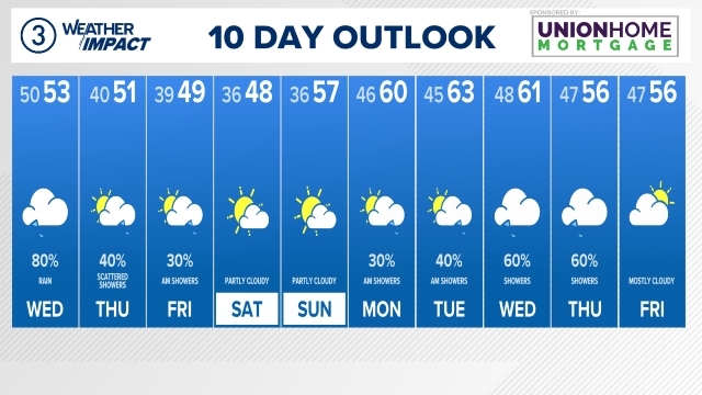
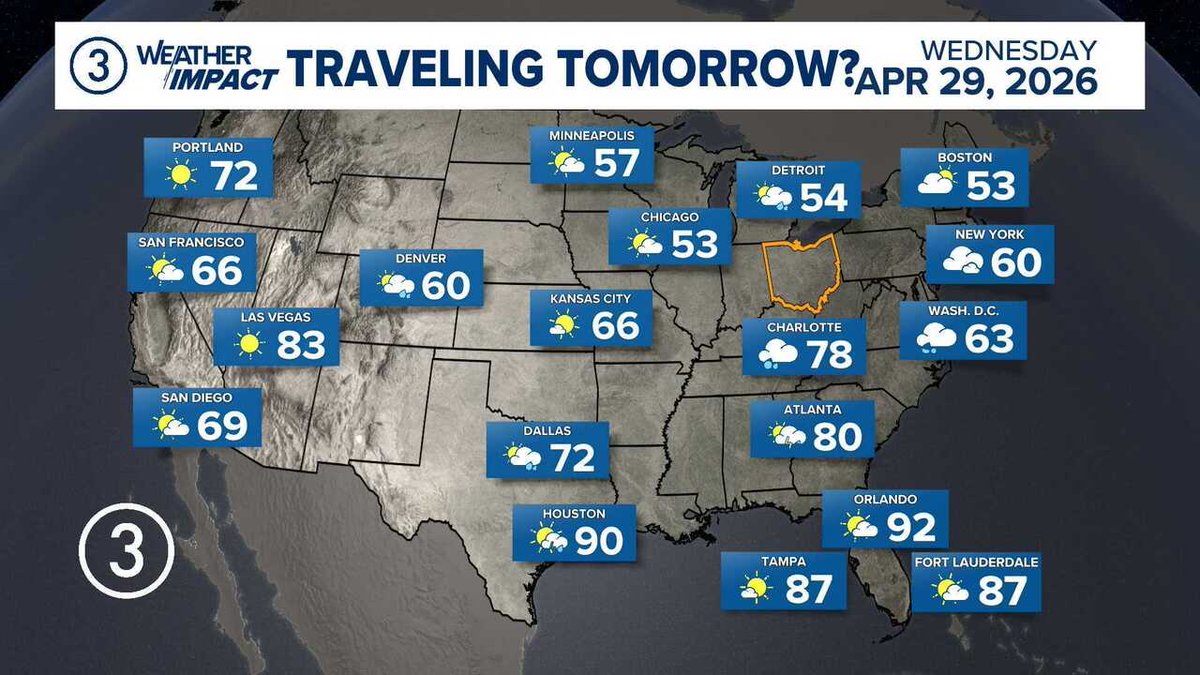
WEATHER IMPACT | It's April 28, 2026 at 11:30PM. Here's your very latest Northeast Ohio extended forecast. Get more weather on the 3News App from @wkyc #3weather #ohwx
[Delayed Report] On Apr 28, at 12:14 AM EDT, Greenville [Darke Co, OH] 911 Call Center reports Tstm Wnd Dmg. Trees down. Time estimated from RADAR. #ohwx mesonet.agron.iastate.edu/lsr/?by=wfo&wf…
![ds_wx03's tweet image. [Delayed Report] On Apr 28, at 12:14 AM EDT, Greenville [Darke Co, OH] 911 Call Center reports Tstm Wnd Dmg. Trees down. Time estimated from RADAR. #ohwx mesonet.agron.iastate.edu/lsr/?by=wfo&wf…](https://pbs.twimg.com/media/HHBRykDW0AMjPZC.jpg)

At 8:40 PM EDT, 2 W Middle Point [Van Wert Co, OH] Mesonet reports Non-Tstm Wnd Gst of M51 MPH. Mesonet station AS860 Van Wert. #ohwx mesonet.agron.iastate.edu/lsr/?by=wfo&wf…
![TomCoomes's tweet image. At 8:40 PM EDT, 2 W Middle Point [Van Wert Co, OH] Mesonet reports Non-Tstm Wnd Gst of M51 MPH. Mesonet station AS860 Van Wert. #ohwx mesonet.agron.iastate.edu/lsr/?by=wfo&wf…](https://pbs.twimg.com/media/HG9Bbb8XIAEdKwB.jpg)
[Delayed Report] On Apr 28, at 12:02 AM EDT, Union City [Darke Co, OH] 911 Call Center reports Tstm Wnd Dmg. Trees down. Time estimated from RADAR. #ohwx mesonet.agron.iastate.edu/lsr/?by=wfo&wf…
![ds_wx03's tweet image. [Delayed Report] On Apr 28, at 12:02 AM EDT, Union City [Darke Co, OH] 911 Call Center reports Tstm Wnd Dmg. Trees down. Time estimated from RADAR. #ohwx mesonet.agron.iastate.edu/lsr/?by=wfo&wf…](https://pbs.twimg.com/media/HHBRoKZXcAAliWo.jpg)


Don't worry it will be quite a lovely day after the soggy sleeping weather overnight! But get ready, there's more rain and much cooler air in the forecast ... let's talk! 🙌 #ohwx #weather #columbusohio

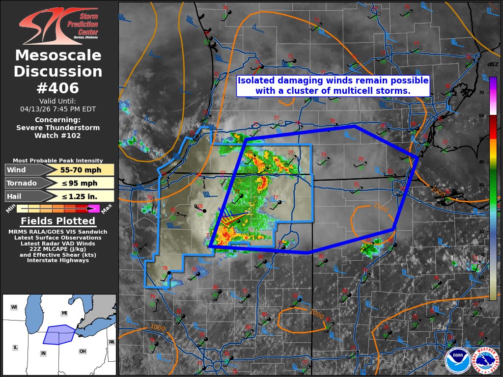
A Severe Thunderstorm Watch has been issued for parts of Indiana, Kentucky, Ohio, Pennsylvania, Virginia and West Virginia until 8 PM EDT Hail up to ping pong size, wind gusts to 65mph, and frequent lightning will be possible. #INwx #KYwx #OHwx #PAwx #VAwx #WVwx

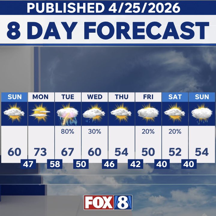
NEW 8 DAY FORECAST 👀 ⬇️ SUNDAY – The PICK DAY this weekend- Sunshine + warmer temps 🌡️📈🌤️ MONDAY – Warmest day next week - highs in the 70s🌡️📈☀️ TUESDAY – The WETTEST day… Downpours and storms 🌧️⚡️💦☔️ END OF APRIL / EARLY MAY – Below normal temperatures… 🌡️📉 #ohwx
Damp start to the day, and beginning a cool trend. 50s for the next few days, and possible frost/freeze issues for the end of the week and into the weekend! #ohwx #pawx
WEATHER IMPACT | Here's a quick check of the radar. Get more weather on the 3News App or at wkyc.com/weather from @wkyc #3weather #ohwx
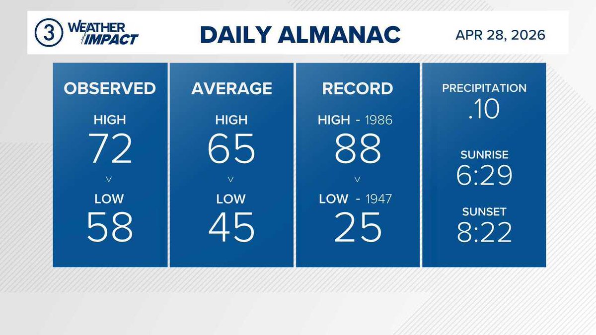
WEATHER IMPACT | Check out yesterday's official almanac. Weather is always available on the 3News App from @wkyc #3weather #ohwx
WEATHER IMPACT | Here's a look at the current weather and temperatures. Get your forecast anytime on the 3News App from @wkyc #3weather #ohwx
WEATHER IMPACT | It's April 28, 2026 at 11:30PM. Here's your very latest Northeast Ohio extended forecast. Get more weather on the 3News App from @wkyc #3weather #ohwx
WEATHER IMPACT | Here's a quick check of the radar. Get more weather on the 3News App or at wkyc.com/weather from @wkyc #3weather #ohwx


[Delayed Report] On Apr 28, at 12:10 AM EDT, New Madison [Darke Co, OH] Trained Spotter reports Tstm Wnd Dmg. Large branch down in neighborhood. Photo verified. Time estimated from RADAR. #ohwx mesonet.agron.iastate.edu/lsr/?by=wfo&wf…
![ds_wx03's tweet image. [Delayed Report] On Apr 28, at 12:10 AM EDT, New Madison [Darke Co, OH] Trained Spotter reports Tstm Wnd Dmg. Large branch down in neighborhood. Photo verified. Time estimated from RADAR. #ohwx mesonet.agron.iastate.edu/lsr/?by=wfo&wf…](https://pbs.twimg.com/media/HHB5qH6XYAA1lBD.jpg)
[Delayed Report] On Apr 28, at 12:10 AM EDT, New Madison [Darke Co, OH] Trained Spotter reports Tstm Wnd Dmg. Large branch down in neighborhood. Photo verified. Time estimated from RADAR. #ohwx mesonet.agron.iastate.edu/lsr/?by=wfo&wf…
![wxenthus's tweet image. [Delayed Report] On Apr 28, at 12:10 AM EDT, New Madison [Darke Co, OH] Trained Spotter reports Tstm Wnd Dmg. Large branch down in neighborhood. Photo verified. Time estimated from RADAR. #ohwx mesonet.agron.iastate.edu/lsr/?by=wfo&wf…](https://pbs.twimg.com/media/HHB5qIdXAAEHDvh.jpg)

[Delayed Report] On Apr 28, at 12:10 AM EDT, New Madison [Darke Co, OH] Trained Spotter reports Tstm Wnd Dmg. Large branch down in neighborhood. Photo verified. Time estimated from RADAR. #ohwx mesonet.agron.iastate.edu/lsr/?by=wfo&wf…
![iembot_iln's tweet image. [Delayed Report] On Apr 28, at 12:10 AM EDT, New Madison [Darke Co, OH] Trained Spotter reports Tstm Wnd Dmg. Large branch down in neighborhood. Photo verified. Time estimated from RADAR. #ohwx mesonet.agron.iastate.edu/lsr/?by=wfo&wf…](https://pbs.twimg.com/media/HHB5qICXQAADT-4.jpg)

Tracking rain hour-by-hour. wtrf.com/wheeling/wheel… #WVWX #ohwx #pawx #WestVirginia #Ohio #weather #forecast #tuesday #rain @WTRF7News @StormTracker7

WEATHER IMPACT | Here's a look at the current weather and temperatures. Get your forecast anytime on the 3News App from @wkyc #3weather #ohwx

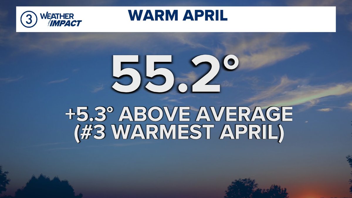
Warmest April on record still on track! Even with a much cooler finish (the next 2 days) to April, we will likely finish the month 0.3° above the record for the month, & 6.8° above normal 🤯 Shocking after the 7th warmest March. Full forecast: nbc4i.com/weather #ohwx

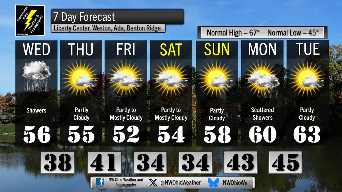
Showers through Wednesday. Highs in the middle 50s. Clearing Wednesday Night. Lows in the upper 30s. #OHwx #weather

[Delayed Report] On Apr 28, at 12:14 AM EDT, Greenville [Darke Co, OH] 911 Call Center reports Tstm Wnd Dmg. Trees down. Time estimated from RADAR. #ohwx mesonet.agron.iastate.edu/lsr/?by=wfo&wf…
[Delayed Report] On Apr 28, at 12:14 AM EDT, Greenville [Darke Co, OH] 911 Call Center reports Tstm Wnd Dmg. Trees down. Time estimated from RADAR. #ohwx mesonet.agron.iastate.edu/lsr/?by=wfo&wf…
![iembot_iln's tweet image. [Delayed Report] On Apr 28, at 12:14 AM EDT, Greenville [Darke Co, OH] 911 Call Center reports Tstm Wnd Dmg. Trees down. Time estimated from RADAR. #ohwx mesonet.agron.iastate.edu/lsr/?by=wfo&wf…](https://pbs.twimg.com/media/HHBRyjdXQAAoV6X.jpg)
[Delayed Report] On Apr 28, at 12:14 AM EDT, Greenville [Darke Co, OH] 911 Call Center reports Tstm Wnd Dmg. Trees down. Time estimated from RADAR. #ohwx mesonet.agron.iastate.edu/lsr/?by=wfo&wf…
![wxenthus's tweet image. [Delayed Report] On Apr 28, at 12:14 AM EDT, Greenville [Darke Co, OH] 911 Call Center reports Tstm Wnd Dmg. Trees down. Time estimated from RADAR. #ohwx mesonet.agron.iastate.edu/lsr/?by=wfo&wf…](https://pbs.twimg.com/media/HHBRyiQWwAIJTIS.jpg)


WEATHER IMPACT | Here's a quick check of the radar. Get more weather on the 3News App or at wkyc.com/weather from @wkyc #3weather #ohwx
WEATHER IMPACT | It's April 28, 2026 at 11:30PM. Here's your very latest Northeast Ohio extended forecast. Get more weather on the 3News App from @wkyc #3weather #ohwx
Damp start to the day, and beginning a cool trend. 50s for the next few days, and possible frost/freeze issues for the end of the week and into the weekend! #ohwx #pawx


WEATHER IMPACT | Here's a look at the current weather and temperatures. Get your forecast anytime on the 3News App from @wkyc #3weather #ohwx

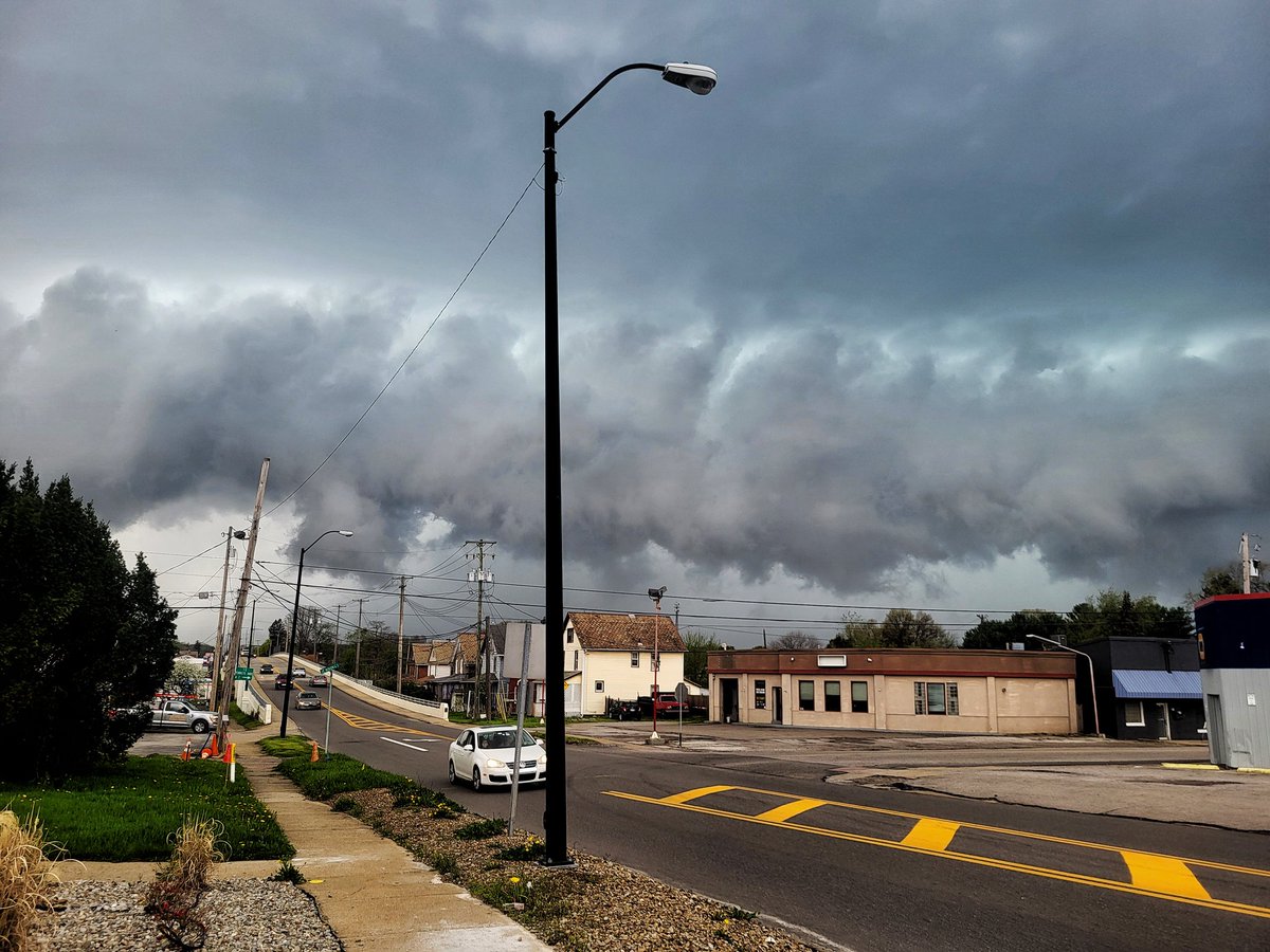
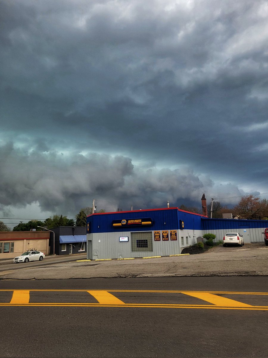
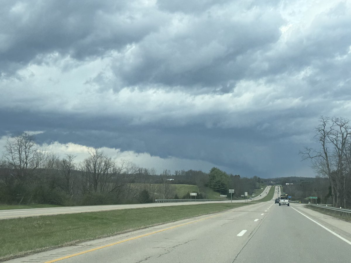
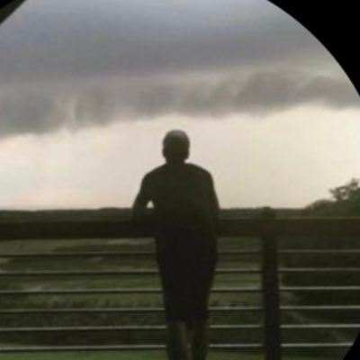
Great shot from Jessica Ortiz in Vermilion, OH! A striking shelf cloud rolling in off Lake Erie this afternoon. Plum wild indeed! 📸☁️ #OHwx #YallSquad


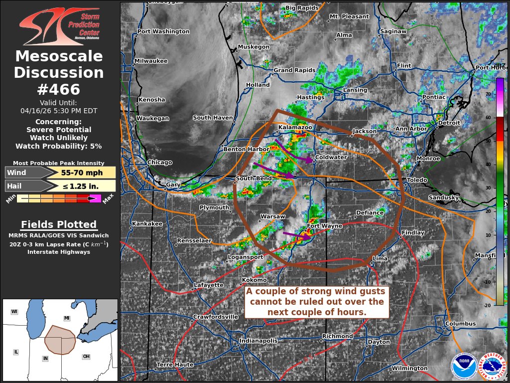
We continue to monitor potential for severe weather Monday evening into Monday night. Damaging winds and embedded tornadoes are the main concerns, but hail and heavy rain are also possible. The best chances for severe weather will be west of US-31. #INwx #OHwx #MIwx

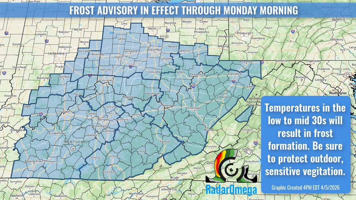
Frost Advisories are in effect until Monday morning in parts of the OH Valley. Temperatures in the low to mid 30s will support widespread frost formation. Sensitive plants could be impacted, so protect outdoor vegetation. #KYwx #OHwx #INwx #WVwx
Showers and scattered thunderstorms will continue to develop for the remainder of the afternoon and into tonight. Some stronger thunderstorms will be possible mainly across Northwest Ohio. #ohwx #pawx


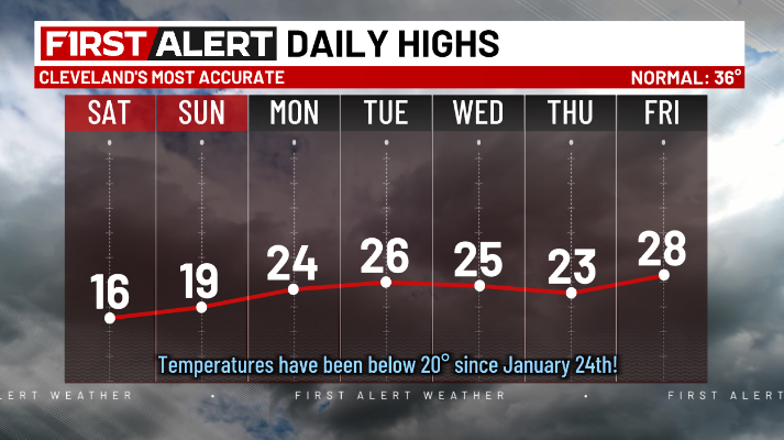
My colleague just walked into the weather office and said, "I'm sick of this cold!" Me too, @KOINER1943! 🤣 While we will remain below normal for the foreseeable future, we'll at least get into the 20s next week. It's something! #ohwx @cleveland19news
WEATHER IMPACT | Check out yesterday's official almanac. Weather is always available on the 3News App from @wkyc #3weather #ohwx
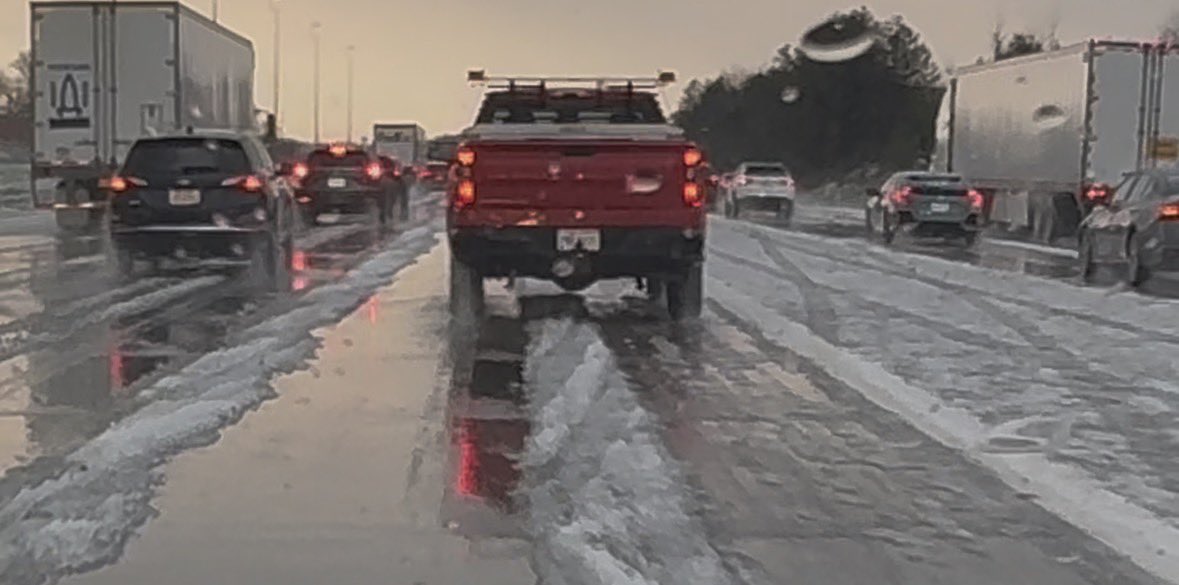
I-271 near Bedford is an absolute mess right now due to copious amounts of hail on the roadway. #OHwx @NWSCLE
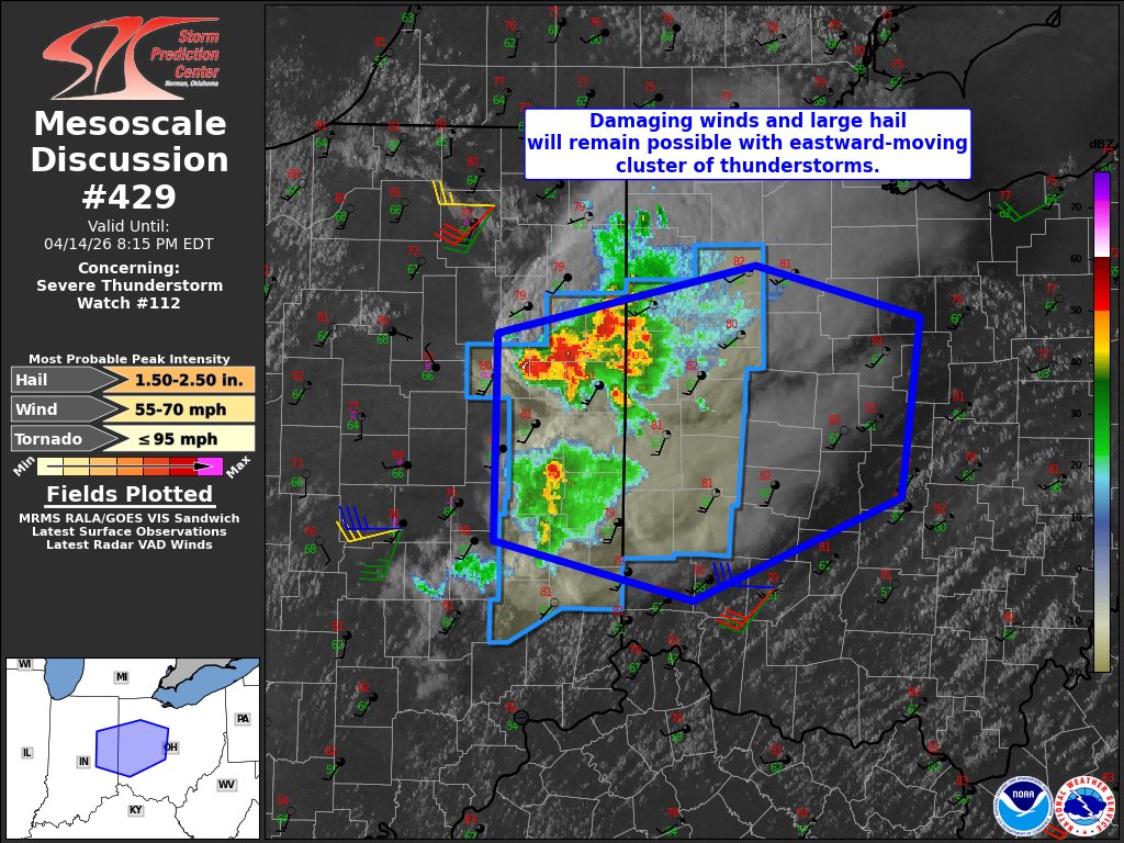
SEVERE STORM WARNING! A Severe Thunderstorm Warning for Jefferson, Harrison, Carroll has been issued until Apr 14, 2026 6:00PM Share this post to ALERT friends and family NOW! Keep an eye on the radar with the @wkyc app! Stay connected with me. #3weather #wx #OHwx

Scattered strong to severe storms today with hail (~1 inch) and wind (up to 60 mph) as the main threats. A few tornadoes will be possible. Stay weather aware and get your latest updates on our website or your favorite news outlet. #INwx #MIwx #OHwx


A really cool shot from @EarthCam this morning from high above downtown Cleveland of the dense fog! Only the city's tallest buildings punched through the fog layer. #OHwx

Something went wrong.
Something went wrong.
United States Trends
- 1. Comey N/A
- 2. #questpit N/A
- 3. #DaredevilBornAgain N/A
- 4. #PorVida N/A
- 5. DuPont N/A
- 6. Shingles N/A
- 7. Earn Now N/A
- 8. Replymer N/A
- 9. Deloitte N/A
- 10. #Pay_Attention_To_HYBE N/A
- 11. Baepsae N/A
- 12. #GoSpursGo N/A
- 13. Neverness to Everness N/A
- 14. Will Kroos N/A
- 15. Tiago N/A
- 16. Game 6 N/A
- 17. Pasta N/A
- 18. Dostal N/A
- 19. Jamie Benn N/A
- 20. Nacho N/A