
GeoInformatics
@Geoinformatics1
GeoInformatics, knowledge for surveying, mapping and GIS Professionals. http://www.geoinformatics.com
You might like


Fugro and Autodesk have partnered and launched Fugro’s GeoDin® Ground plugin for Autodesk’s Civil 3D software. geoinformatics.com/fugro-and-auto…

Bentley Systems Announces Winners of the 2024 Going Digital Awards. geoinformatics.com/bentley-system…

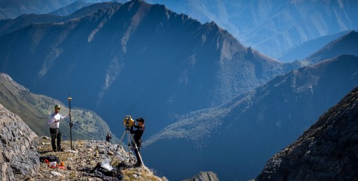
Working alongside TERIA, as well as scientists and academics at the site, Topcon Positioning Systems was called upon to provide geospatial technology that would assess the glacier’s movements and solve the riddle of its supposed growth. geoinformatics.com/solving-the-my…
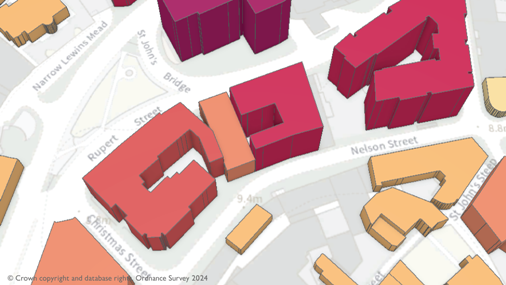
Emergency services will be given even greater support to carry out their critical tasks with the latest release of detailed location data from Ordnance Survey . geoinformatics.com/a-safer-britai…
INTERGEO Expo and Conference : 579 exhibitors and over 17.000 visitors from 121 countries, the EXPO demonstrated its international reach and the industry’s resilience despite global economic challenges. geoinformatics.com/intergeo-2024-…
geoinformatics.com
INTERGEO 2024 is the International Top Event of the GEO Industry
The event, centered around geodesy, geoinformation, and land management, presented innovative geodata-based solutions to an international audience over three days, addressing current challenges such...
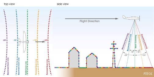
RIEGL is proud to announce winning the Wichmann INTERGEO Expo and Conference Innovations Award in the Hardware category with its turnkey system solution for UAV-based laser scanning, the 𝐑𝐈𝐄𝐆𝐋 𝐦𝐢𝐧𝐢𝐕𝐔𝐗-𝟑𝐔𝐀𝐕 with 𝐑𝐢𝐋𝐎𝐂-𝐄. geoinformatics.com/riegl-wins-the…

PIX4Dcatch is now integrated with three of the world’s most trusted GNSS systems—Leica Zeno FLX100, Trimble DA2, and TopCon HiPer CR. geoinformatics.com/pix4dcatch-wel…
geoinformatics.com
PIX4Dcatch welcomes the big three: Topcon, Trimble, and Leica
PIX4Dcatch is now integrated with three of the world’s most trusted GNSS systems—Leica Zeno FLX100, Trimble DA2, and TopCon HiPer CR.
Consistently pushing the boundaries of what’s possible in drone mapping, Wingtra is excited to introduce MAP61, the most efficient mapping sensor on the market. geoinformatics.com/introducing-ma…
geoinformatics.com
Introducing MAP61: the next level of drone mapping efficiency
Consistently pushing the boundaries of what’s possible in drone mapping, Wingtra is excited to introduce MAP61, the most efficient mapping sensor on the market.
This collaboration is set to create one of the world’s largest high-precision GNSS positioning service offers for the mass market, giving customers across the globe a blend of performance, pricing, and delivery options. geoinformatics.com/u-blox-and-top…
geoinformatics.com
u-blox and Topcon Positioning Systems announce strategic partnership
This collaboration is set to create one of the world’s largest high-precision GNSS positioning service offers for the mass market, giving customers across the globe a blend of performance, pricing,...
Trimble Inc. and Worldsensing announced the introduction of a solution for long term 3D ground and structural movement monitoring that will combine Trimble 4D Control (T4D) monitoring software with the new Trimble GNSS Meter, powered by Worldsensing. geoinformatics.com/trimble-and-wo…
Virtual Surveyor has significantly reorganized its smart drone surveying software plans with the addition of the Productivity Tools suite to the Ridge plan. geoinformatics.com/virtual-survey…
GeoLas Systems GmbH announced the launch of the ELMAP-P, a revolutionary airborne LiDAR pod designed specifically for Cessna aircraft models 172, 182, and 206. geoinformatics.com/geolas-systems…

Leica Geosystems part of Hexagon introduced the Leica GS05, a compact, lightweight GNSS Smart Antenna featuring calibration-free tilt compensation designed for surveyors who tackle challenging jobs and work long hours. geoinformatics.com/leica-geosyste…

Upgraded with Surfaces support, Emlid Flow now has a full range of tools for earthworks, topographic, and as-built surveys. geoinformatics.com/the-emlid-flow…

Bentley Systems announced it has acquired 3D geospatial company Cesium. geoinformatics.com/bentley-system…
geoinformatics.com
Bentley Systems Acquires 3D Geospatial Company Cesium
Cesium is recognized as the foundational open platform for creating powerful 3D geospatial applications, and its 3D Tiles open standard has been widely adopted by leading enterprises, governments,...
Enter the UltraCam Dragon 4.1 — a revolutionary hybrid aerial mapping system that combines advanced oblique imaging and Lidar scanning from RIEGL Laser Measurement Systems into a single, integrated device. geoinformatics.com/high-end-data-…
Fugro has leveraged its expertise to develop a digital twin for Counties Energy’s entire distribution network, enhancing Counties Energy’s ability to manage its assets with greater precision and foresight. geoinformatics.com/fugro-roames-d…
In this article, we will take a closer look at the different geospatial analytic tools available to construction professionals, as well as the benefits of incorporating them into a BIM workflow. geoinformatics.com/streamlining-b…

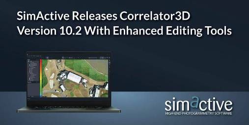
SimActive Inc. Releases Correlator3D Version 10.2. geoinformatics.com/simactive-rele…
It brings a host of optimisations and enhancements to Cadcorp SIS Desktop, Cadcorp Cover Modeller, and Cadcorp SIS WebMap. geoinformatics.com/new-updates-to…
geoinformatics.com
New updates to Cadcorp SIS 9.1
It brings a host of optimisations and enhancements to Cadcorp SIS Desktop, Cadcorp Cover Modeller, and Cadcorp SIS WebMap.


United States Trends
- 1. Thanksgiving 2.01M posts
- 2. Jack White 5,012 posts
- 3. Packers 38.4K posts
- 4. Thankful 408K posts
- 5. #GBvsDET 3,023 posts
- 6. #GoPackGo 5,894 posts
- 7. Wicks 4,227 posts
- 8. Jordan Love 5,583 posts
- 9. Goff 6,073 posts
- 10. #OnePride 5,688 posts
- 11. Jameson Williams 1,703 posts
- 12. Jamo 3,307 posts
- 13. Turkey 266K posts
- 14. Tom Kennedy N/A
- 15. Seven Nation Army N/A
- 16. Amon Ra 2,384 posts
- 17. LaFleur 2,191 posts
- 18. Brian Branch N/A
- 19. Ray J 3,050 posts
- 20. Carrington Valentine N/A
You might like
-
 gisgeography.com
@GisGeography -
 GIM International
@gim_intl -
 Esri Training
@EsriTraining -
 GoGeomatics.ca
@GoGeomatics -
 Geoawesome
@geoawesome_dgtl -
 GIS Day
@gisday -
 🇨🇦 GIS & Geomatics
@CanadianGIS -
 Everything is Somewhere
@surveying -
 Esri Canada
@esricanada -
 Geo-matching.com
@Geomatching -
 Esri User Conference
@EsriUC -
 Geospatial Professional Network
@URISA -
 MAPPS
MAPPS
@MAPPSorg -
 Geo:Connexion
@Geoconnexion -
 Hexagon Safety, Infrastructure & Geospatial
@HexagonSIG
Something went wrong.
Something went wrong.