
Geo-matching.com
@Geomatching
http://Geo-matching.com The world’s largest product platform for surveying, positioning and machine guidance.
You might like


The @FJDynamics Trion P2 LiDAR Scanner is portable, precise and built to capture more. Weighing just 700g, it offers cm-level accuracy, real-time colorized point clouds and multi-format outputs for surveyors and 3D mapping professionals. geo-matching.com/products/fjd-t…

Precision in the palm of your hand. The Archer 4 Rugged Handheld + GNSS Expansion Pod = real-time RTK accuracy in any environment. Read more via @JuniperSystems on Geo-matching: geo-matching.com/articles/preci… #RTK #GNSS #Geospatial

🚀 Explore extreme long-range scanning up to 6000 m! The NEW @RIEGL VZ-6000i-26 delivers precision, power, and performance for snow & ice mapping. 🎥 Watch the stunning mountain & glacier scan now: loom.ly/sE64v8Q #RIEGL #LiDAR #3DMapping #InnovationInAction

Meet the @FJDynamics Trion V4E Mini RTK Receiver! Ultra-light 320g ✅ Centimeter-level accuracy ✅ IP67 waterproof & drop-resistant ✅ 12+ hrs battery ✅ Tilt compensation up to 30° Perfect for smart farming, robotic mowing & digital construction. 👉 geo-matching.com/products/fjd-t…
The Archer 4 GNSS Expansion Pod brings RTK accuracy worldwide. Easily set up with the Archer Connect app and map with cm-level precision. Watch via @JuniperSystems on Geo-matching: geo-matching.com/videos/all-in-… #RTK #GNSS #Geospatial

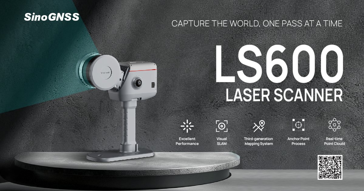
Capture the world, one pass at a time. ComNav LS600 fuses LiDAR, IMU & camera for fast, full-colour point clouds - indoor/outdoor in a compact all-in-one unit. Perfect for surveying, urban, mining & emergency response. Learn more at comnavtech.com/product/3d/LS6… #LiDAR @ComNav_Tech

Inertial Labs thanks you for joining them at INTERGEO 2025! One of their highlights was showcasing the Teledyne EchoOne integrated with RESEPI LiDAR Payloads. 💡 Missed the demo? No worries – you can explore the solution online: loom.ly/iG1ndGI

When every degree matters, the TruAngle® II keeps you locked on target. Designed for professionals who can’t afford guesswork, it delivers unmatched angular accuracy with the speed and reliability your mapping demands. Discover more: loom.ly/wZ0MVyw

That’s a wrap on Intergeo 2025! 🌍 A huge thank you to everyone who visited the OXTS stand, it was fantastic to connect with so many survey and mapping professionals from around the world. If you missed us at Intergeo, discover more about OxTS here: loom.ly/b7rM0ko

What is Galileo High Accuracy Service? In this blog, @JuniperSystems explains Galileo HAS, what it does, and what it means for positioning professionals who depend on reliable, high-accuracy positioning. geo-matching.com/articles/what-… #GNSS #GalileoHAS #JuniperSystems #GeoMatching

The CHCNAV Vili i100 employs SLAM technology to comprehensively enhance survey efficiency. Even in environments with complete GNSS signal obstruction, it can still maintain 5-centimeter accuracy within a 20-meter range. Learn more: loom.ly/lOPnA0w

If you own a Skadi Gold, Skadi 300, or Skadi 200 RTK GNSS receiver from Eos Positioning Systems, you can replace your included Skadi Standard Handle with the Skadi Smart Handle! Discover all features here: loom.ly/bh5--dA

📡 Live from INTERGEO 2025! Inertial Labs is presenting the Teledyne EchoOne with RESEPI – a next-generation airborne LiDAR solution that’s setting new standards in accuracy, versatility, and mapping efficiency. 🔎 Product details here: loom.ly/iG1ndGI

Just launched at Intergeo 2025! 🚀 UltraCam Dragon 4.2 & UltraCam Merlin 5.0: Hybrid imaging and premium true nadir mapping – all with Sony IMX811. Next-level aerial mapping with @vexcel_imaging is here. loom.ly/DEYu0po
When precision can’t wait, the TruPulse® 200i delivers fast, reliable measurements you can trust. With Dual Mode connectivity, an ultra-bright HUD, and a streamlined interface, it adapts to any job, in any condition. Discover more: loom.ly/wXCbZNs

Take UAV mapping to the next level. ✈️ Visit OXTS at Intergeo 2025 and talk to the people behind the OXTS xRED GNSS/INS, a lightweight, powerful localisation tool designed to embed directly into UAV payloads. Eager to learn more now? - loom.ly/5sjcK7I

The Geode GNS3H GNSS Receiver with Galileo HAS delivers decimeter-level accuracy, rugged reliability, and all GNS3M features. Watch the full video on Geo-matching: geo-matching.com/videos/introdu… @JuniperSystems #GNSS #GalileoHAS #GeoMatching #Geospatial

As CHCNAV's next-generation GNSS receiver, the Vili i100 employs SLAM technology to comprehensively enhance survey efficiency. Even in environments with complete GNSS signal obstruction. Learn more: loom.ly/lOPnA0w

Tired of stitching indoor & outdoor surveys? @ComNav_Tech's new LS600 fuses LiDAR+IMU+camera for fast, coloured point clouds. Compact turnkey for surveying, urban mapping, mining & emergency response. More at: comnavtech.com/product/3d/LS6… #LiDAR #SensorFusion #SLAM #PointCloud
CHC Navigation is coming to INTERGEO Expo and Conference 2025! Visit them at Booth 0C081 to see their SLAM Scanner, LiDAR and Drone. Meet their experts and explore mapping solutions designed for efficiency and accuracy. Discover more about CHCNAV here: loom.ly/rxQdvTw


United States Trends
- 1. Good Thursday 26.8K posts
- 2. Happy Friday Eve N/A
- 3. #thursdayvibes 2,078 posts
- 4. #thursdaymotivation 1,293 posts
- 5. ESPN Bet N/A
- 6. #Talus_Labs N/A
- 7. #ThursdayThoughts 1,313 posts
- 8. Lakers 84.8K posts
- 9. #River 4,303 posts
- 10. Wemby 28.6K posts
- 11. Vatican 10.6K posts
- 12. Unplanned 6,256 posts
- 13. Grapefruit 1,480 posts
- 14. Marcus Smart 6,900 posts
- 15. Captain Kangaroo 1,266 posts
- 16. Blazers 9,886 posts
- 17. Russ 12K posts
- 18. Richard 45.4K posts
- 19. Shroud 5,775 posts
- 20. Shabbat 7,301 posts
You might like
-
 Geospatial World
@geospatialworld -
 GIM International
@gim_intl -
 LeicaGeosystems
@LeicaGeosystems -
 Everything is Somewhere
@surveying -
 Spatial Media - GeoTech Education, News & Tips
@SpatialCORE -
 🇨🇦 GIS & Geomatics
@CanadianGIS -
 Geoawesome
@geoawesome_dgtl -
 GoGeomatics.ca
@GoGeomatics -
 GIS Day
@gisday -
 GIS Resources
@GISResources -
 RIEGL
RIEGL
@RIEGL -
 Hexagon Safety, Infrastructure & Geospatial
@HexagonSIG -
 Esri User Conference
@EsriUC -
 GeoNewsfeed
@GeoNewsfeed -
 Geo:Connexion
@Geoconnexion
Something went wrong.
Something went wrong.