
你可能會喜歡


Fugro and Autodesk have partnered and launched Fugro’s GeoDin® Ground plugin for Autodesk’s Civil 3D software. geoinformatics.com/fugro-and-auto…
geoinformatics.com
Fugro and Autodesk unveil software integration for smarter, safer construction
Fugro and Autodesk have partnered and launched Fugro’s GeoDin® Ground plugin for Autodesk’s Civil 3D software.
Bentley Systems Announces Winners of the 2024 Going Digital Awards. geoinformatics.com/bentley-system…

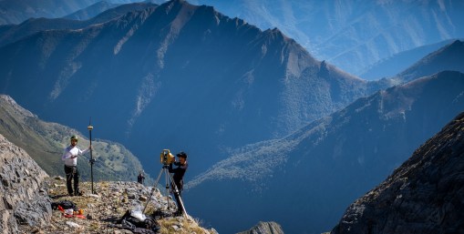
Working alongside TERIA, as well as scientists and academics at the site, Topcon Positioning Systems was called upon to provide geospatial technology that would assess the glacier’s movements and solve the riddle of its supposed growth. geoinformatics.com/solving-the-my…
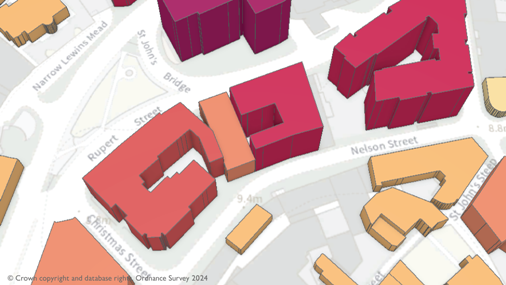
Emergency services will be given even greater support to carry out their critical tasks with the latest release of detailed location data from Ordnance Survey . geoinformatics.com/a-safer-britai…
INTERGEO Expo and Conference : 579 exhibitors and over 17.000 visitors from 121 countries, the EXPO demonstrated its international reach and the industry’s resilience despite global economic challenges. geoinformatics.com/intergeo-2024-…

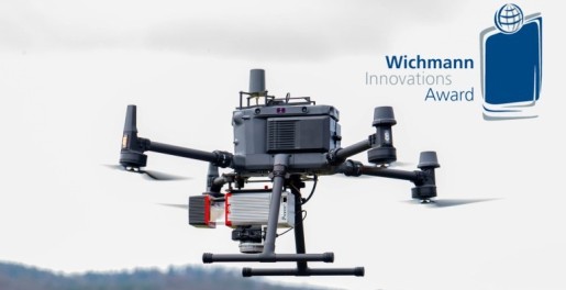
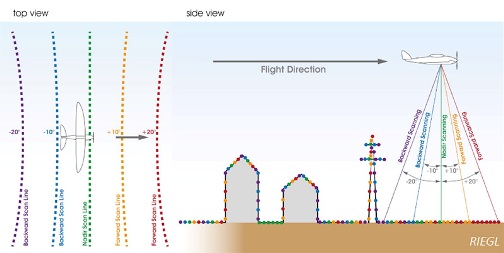
RIEGL is proud to announce winning the Wichmann INTERGEO Expo and Conference Innovations Award in the Hardware category with its turnkey system solution for UAV-based laser scanning, the 𝐑𝐈𝐄𝐆𝐋 𝐦𝐢𝐧𝐢𝐕𝐔𝐗-𝟑𝐔𝐀𝐕 with 𝐑𝐢𝐋𝐎𝐂-𝐄. geoinformatics.com/riegl-wins-the…
PIX4Dcatch is now integrated with three of the world’s most trusted GNSS systems—Leica Zeno FLX100, Trimble DA2, and TopCon HiPer CR. geoinformatics.com/pix4dcatch-wel…

Consistently pushing the boundaries of what’s possible in drone mapping, Wingtra is excited to introduce MAP61, the most efficient mapping sensor on the market. geoinformatics.com/introducing-ma…
This collaboration is set to create one of the world’s largest high-precision GNSS positioning service offers for the mass market, giving customers across the globe a blend of performance, pricing, and delivery options. geoinformatics.com/u-blox-and-top…

Trimble Inc. and Worldsensing announced the introduction of a solution for long term 3D ground and structural movement monitoring that will combine Trimble 4D Control (T4D) monitoring software with the new Trimble GNSS Meter, powered by Worldsensing. geoinformatics.com/trimble-and-wo…
geoinformatics.com
Trimble and Worldsensing Collaborate to Expand Monitoring Solutions
Trimble and Worldsensing announced the introduction of a solution for long term 3D ground and structural movement monitoring that will combine Trimble 4D Control (T4D) monitoring software with the...
Virtual Surveyor has significantly reorganized its smart drone surveying software plans with the addition of the Productivity Tools suite to the Ridge plan. geoinformatics.com/virtual-survey…
geoinformatics.com
Virtual Surveyor Adds Productivity Tools
Virtual Surveyor has significantly reorganized its smart drone surveying software plans with the addition of the Productivity Tools suite to the Ridge plan.
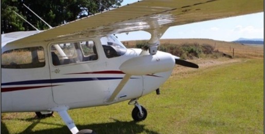
GeoLas Systems GmbH announced the launch of the ELMAP-P, a revolutionary airborne LiDAR pod designed specifically for Cessna aircraft models 172, 182, and 206. geoinformatics.com/geolas-systems…
Leica Geosystems part of Hexagon introduced the Leica GS05, a compact, lightweight GNSS Smart Antenna featuring calibration-free tilt compensation designed for surveyors who tackle challenging jobs and work long hours. geoinformatics.com/leica-geosyste…
geoinformatics.com
Leica Geosystems launches lightweight GS05 GNSS Smart Antenna
Leica Geosystems, part of Hexagon, introduced the Leica GS05, a compact, lightweight GNSS Smart Antenna featuring calibration-free tilt compensation designed for surveyors who tackle challenging jobs...
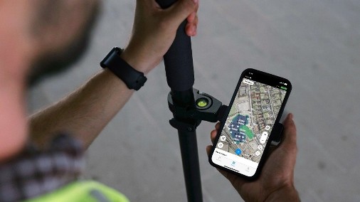
Upgraded with Surfaces support, Emlid Flow now has a full range of tools for earthworks, topographic, and as-built surveys. geoinformatics.com/the-emlid-flow…
Bentley Systems announced it has acquired 3D geospatial company Cesium. geoinformatics.com/bentley-system…

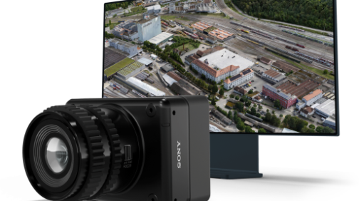
Enter the UltraCam Dragon 4.1 — a revolutionary hybrid aerial mapping system that combines advanced oblique imaging and Lidar scanning from RIEGL Laser Measurement Systems into a single, integrated device. geoinformatics.com/high-end-data-…
Fugro has leveraged its expertise to develop a digital twin for Counties Energy’s entire distribution network, enhancing Counties Energy’s ability to manage its assets with greater precision and foresight. geoinformatics.com/fugro-roames-d…

In this article, we will take a closer look at the different geospatial analytic tools available to construction professionals, as well as the benefits of incorporating them into a BIM workflow. geoinformatics.com/streamlining-b…

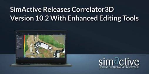
SimActive Inc. Releases Correlator3D Version 10.2. geoinformatics.com/simactive-rele…
It brings a host of optimisations and enhancements to Cadcorp SIS Desktop, Cadcorp Cover Modeller, and Cadcorp SIS WebMap. geoinformatics.com/new-updates-to…


United States 趨勢
- 1. Klay 19.6K posts
- 2. #AEWFullGear 69.5K posts
- 3. Lando 95.8K posts
- 4. McLaren 42.3K posts
- 5. #LasVegasGP 180K posts
- 6. LAFC 15.1K posts
- 7. Hangman 9,716 posts
- 8. Ja Morant 8,579 posts
- 9. Gambino 2,205 posts
- 10. Swerve 6,309 posts
- 11. Samoa Joe 4,650 posts
- 12. #Toonami 2,784 posts
- 13. Bryson Barnes N/A
- 14. Verstappen 77.4K posts
- 15. Utah 23.9K posts
- 16. Benavidez 15.7K posts
- 17. Kimi 37.6K posts
- 18. Mark Briscoe 4,378 posts
- 19. Fresno State 1,003 posts
- 20. Terry Crews 7,488 posts
你可能會喜歡
-
 Spatial Media - GeoTech Education, News & Tips
@SpatialCORE -
 GIM International
@gim_intl -
 GoGeomatics.ca
@GoGeomatics -
 Geoawesome
@geoawesome_dgtl -
 GIS Day
@gisday -
 🇨🇦 GIS & Geomatics
@CanadianGIS -
 Everything is Somewhere
@surveying -
 Esri Canada
@esricanada -
 Geo-matching.com
@Geomatching -
 Esri User Conference
@EsriUC -
 Geospatial Professional Network
@URISA -
 Geo:Connexion
@Geoconnexion -
 Hexagon Safety, Infrastructure & Geospatial
@HexagonSIG -
 GEO Jobe
@GEOjobeGIS
Something went wrong.
Something went wrong.