
OpenFreeMap
@OpenFreeMapOrg
Open and free custom maps for your website and apps. https://openfreemap.org/ Map data from OpenStreetMap.

OpenFreeMap survived 100,000 requests per second I was about to post about how nice the last 10 months of OpenFreeMap have been. The architecture has really proven itself to be great, Cloudflare has agreed to sponsor the bandwidth, Hetzner servers are super stable as always,…


The country map of Afghanistan above is actually an image that is dynamically generated from a Blade view using @OpenFreeMapOrg and puppeteer and then cached as a base64 encoded string as I don't really want to load a mapping library in every embed.

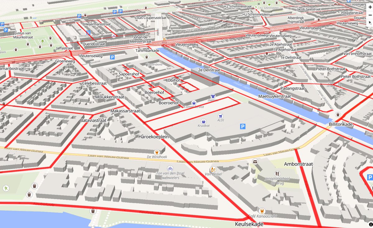
Demo highlight specific streets, using @OpenFreeMapOrg vector tiles in @maplibre bertt.github.io/handige_meeuwe…
One more amazing project using OpenFreeMap: Streetview roadtrip simulator by @nealagarwal Launched today and instantly became the #1 site using @OpenFreeMapOrg ! Neal reached out beforehand and generously provided a $150/month sponsorship via @github Sponsors, fully covering…

I made a streetview roadtrip simulator where we all vote on a direction every 10 seconds Also we have to vote to change the radio station. Enjoy!
Dan Snow created a beautiful website, opentimes.org. I love the minimal design, how immediately functional it is, and it even uses OpenFreeMap! At the bottom of the About page, I found: "I was inspired by the OpenFreeMap project and wanted to use my own domain…

HERE maps just became 10x more expensive. Turns out, they've been billing with the wrong unit price before: 0.00000899 vs 0.00008919 Now that's one thing you don't need to worry about with OpenFreeMap.
Many of you don't know, but @OpenFreeMapOrg is hosted on 2 different servers in 2 different countries: one in Germany and one in Finland. The DNS setup is configured so that if one server is offline, your browser automatically picks the other one. I also made a tiny script that…


That's a super nice and useful project, thank you for making it!

🎉 Thanks @StadiaMaps for the no-key API access! Preview their maps at mapmatrix.veloplanner.com ✨ Also added OpenFreeMap by @hyperknot - such a cool project! #mapping #OpenData #openstreetmap #maps #GIS

Wow, super nice style, didn't know this is possible!

#30DayMapChallenge day 20: OpenStreetMap Carte de #Cassini mondiale 🌐 adding #OSM old map style (1700s) to @OpenFreeMapOrg 🗺️ @hyperknot #OpenAndFree #GeoCommun 📄 Github project: github.com/Viglino/geoser… 🗺️Test online: macarte.ign.fr/carte/0jFLuT/O…


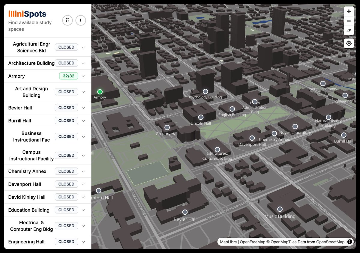
GitHub user plon created an open-source real-time map using OpenFreeMap. It's showing free UIUC study spaces and empty classrooms. The website is open source. illinispots.vercel.app github.com/plon/illinispo…
Added two styles to @OpenFreeMapOrg. Dark and Fiord. You can use them but they are not polished like the three main styles shown on the homepage. Readme: Dark and Fiord is not yet complete. They are unmodified, which means they are exactly as they are on their source repo, with…

One month after launch, OpenFreeMap hit its first sponsorship goal of $175/month! Thanks to our amazing supporters, we can now fully cover server costs. The project is officially self-sustainable!

First month of OpenFreeMap I launched OpenFreeMap on HN exactly a month ago. Well, it's not exactly correct, as I first submitted it to HN 5 days before, when absolutely nothing happened (1). The second time it became the 12th most successful Show HN of 2024 (until today), with…
Thank you @CodingGarden for the super nice video and for making examples in 5 (!) different frameworks! I'll add a link to them on the official page!

In my latest video over on @syntaxfm - I show how to add maps to any app for FREE using @maplibre with @OpenFreeMapOrg tiles created by @hyperknot Examples with Vanilla JS @reactjs @vuejs and @sveltejs available here: github.com/w3cj/openfreem… Watch 🍿 youtube.com/watch?v=UAQogF…
Thanks to our amazing community, we now have our first video tutorial for OpenFreeMap! A big shoutout to @giswqs for integrating it into the Jupyter notebook environment!

🚀 MapLibre Tutorial 15: Create stunning 3D maps using OpenFreeMap vector tiles—all with just a few lines of code! Best of all, it’s completely FREE and requires no API key! 🎥 Watch the video: youtu.be/0s66rlJdBtA 📚 Explore the playlist: bit.ly/maplibre 📝 Check out…


United States Trends
- 1. D’Angelo 283K posts
- 2. Brown Sugar 20.5K posts
- 3. Pentagon 106K posts
- 4. #PortfolioDay 16K posts
- 5. Politico 163K posts
- 6. Young Republicans 13.6K posts
- 7. Drew Struzan 28K posts
- 8. Big 12 13.2K posts
- 9. Scream 5 N/A
- 10. Black Messiah 10.7K posts
- 11. David Bell N/A
- 12. Milei 262K posts
- 13. Soybeans 5,160 posts
- 14. Venables 3,623 posts
- 15. Merino 14.5K posts
- 16. Presidential Medal of Freedom 58.8K posts
- 17. Nick Mangold N/A
- 18. World Cup 329K posts
- 19. Voodoo 21.4K posts
- 20. Baldwin 20.8K posts
Something went wrong.
Something went wrong.