
Severn Partnership Subsurface Mapping
@SP_Subsurface
Chartered #Geomatics Surveyors UK and Worldwide. Providing accurate Utility and Sub-Surface surveys. #RICS #CICES #TSA #Survey #Utilities #GPR #PAS128 #CCTV
You might like


The toys are out today @SPartnership @mobilemapping @LeicaGeo_UKI Pegasus 2 and the @IDS_GeoRadar Stream C working together to map both above and below ground along the beach front 🌊👷🏻♂️ #GPR #mobilemapping #Survey


Connor & Mike ready to present at @crestatucs 2nd Shreswbury Geospatial Forum on air, surface & subsurface equipment. With talks from @KORECGroup and @TopconGB_IRE #geospatial #GPR #subsurface #geospatial #UAV #Survey #3ddata

Thanks to @KORECGroupfor sponsoring & leading with pocket technology to reduce paperwork onsite @SPartnership with below & above ground UAV GPR & Mobile Mapping technology & @TopconGB_IRE with their versatile GTL to increase onsite productivity. #geospatial #mobilemapping #uav


@crestatucs and we now have Connor and Mike @SPartnership presenting on mobile applications


Perfect Day for flying! #UAV #Drone #Survey #photography 🎥✈️☀️

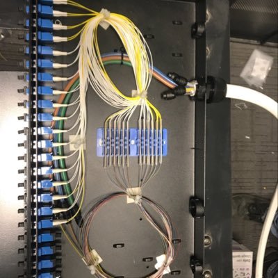
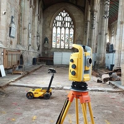
CAD Processing a rather congested Utility Detection Survey today! 💻👨🏻💻 #SurveyLife #autocad #CAD #utilities

CCTV Drainage survey this afternoon trying to discover where surface water is leaking into a foul sewer! 🎥💩🧻👷🏻♂️ #survey #CCTV

🎉WOW @SPartnership now have an Approved Development Scheme (ADS) to support training needs for our survey staff to achieve a @CharteredICES Accreditation. Great achievement for the company and super opportunities for our Surveyors #surveyors #rics #charteredsurveyors #ICES

Tickets and more information below! crestatucs.com/shrewsbury-geo…
Wed 18th Sep #Shrewsbury #Geospatial Forum presents Air Surface & Subsurface Hardware Equipment with technical talks from experts on #air #surface & #subsurface hardware equipment. Speakers from @KORECGroup & @SPartnership introducing topics of above & below ground #mobilemapping


Construction site monitoring📸👷♂️ Job site documentation is essential. Whether you need to share the state of a project with clients or monitor site changes. If you aren’t using drones to document site progress, it might be time to reconsider. #Drones #UAV #monitoring #survey
All Severn Partnership UAV survey are completed with safety as priority! 👷🏻♂️👮🏻♂️ Our PfCO allows us undertake commercial UAV surveys #UAV #dronesafe #drone #surveylife


@SPartnership just blowing the dust off the stumps for their first ever Cricket 🏏Test in 36 years of #Survey against the mighty @StormGeomatics at The Shipston-on-Stour Pavilion brace yourselves our fast bowlers fancy that wicket.

Check out @CharteredICES July/August 2019 Journal @SPartnership Compliance Manager Jim Roberts explains how the latest high-tech survey in the right professional hands helped the #Railway GWR keep on track & battle "the power of the sea" ces.pagelizard.co.uk/webviewer/#ces… @SP_Subsurface

Weekend team completed 7 survey sites with a Total of 10,550 yards surveyed All works completed with no incidents or accidents And England won the cricket World Cup! All round a good weekend if I must say🏏🚆 #highoutput #tracksurvey #CWC19 #survey #everyonehomesafeeveryday #rail

Excited for our team @makeitSEEABLE to be speakers at #Shrewsbury’s first #visualisation of #Geospatial Data Forum hosted by @crestatucs on 24th July. Check out how we combine #AR with #surveying Book tickets👇🏽 crestatucs.com/shrewsbury-geo… #AugmentedReality #GeoNews #VirtualReality
The Stream C about to take off ✈️👷🏻♂️ #GPRSurvey #Surveylife #Surveying @SPartnership @IDS_GeoRadar

This highlights the importance of abiding by the laws set out in CAP393 (Air Navigation Order 2016). All Severn Partnerships remote pilots undertake every flight within these laws as it can lead to serious consequences. #Dronesafe #CAA #Drones #UAV ✈️👷🏻♂️👮🏻♂️
We are very pleased to announce we are now #Gold member accredited with @constructline click here for more information severnpartnership.com/severn-partner……ip-accreditation/ @CNplus #construction #survey #infrastructure
Airside using our Stream C GPR (Ground Penetration Radar) to locate pipes and voids within the grounds surface along the runway. Working to reduce #cost #carbon #casualties in high risk areas #airside #survey #utilities #airportsurvey #streamc #surveytech #gpr


United States Trends
- 1. #SmackDown 31.2K posts
- 2. Caleb Wilson 3,783 posts
- 3. Giulia 10.6K posts
- 4. Lash Legend 3,580 posts
- 5. #TheLastDriveIn 1,448 posts
- 6. #OPLive 1,015 posts
- 7. Chelsea Green 4,504 posts
- 8. Darryn Peterson 2,001 posts
- 9. Kansas 23.6K posts
- 10. Reed Sheppard N/A
- 11. Supreme Court 162K posts
- 12. Sengun 3,489 posts
- 13. #MutantFam N/A
- 14. #Dateline N/A
- 15. Rockets 17.8K posts
- 16. Nia Jax 2,527 posts
- 17. End of 3rd 1,412 posts
- 18. Georgetown 3,198 posts
- 19. Dizzy 12.6K posts
- 20. Tiller 4,163 posts


Something went wrong.
Something went wrong.