
Rajkumar vivasaayi
@beatbox_raju
birdwatching , insectlover 🌲💐🌱🌿🌿🌾☘️🪴🌳#beatboxer
You might like


GIS Data Analyst Recap: QGIS + PostgreSQL + Geospatial Relational Table(Substation & Maintenance) + Adding Test Data. If you do not have PostgreSQL with PostGIS installed, view the following link to get you up and running. x.com/DatJot/status/… Note, this is for a Windows…


GIS Data Analyst Recap: PostgreSQL + PostGIS If you are not yet exploring QGIS paired with PostgreSQL and PostGIS, I strongly urge you to dive in. It is a game changer. This powerhouse combo unlocks a world of geospatial analysis, from seamless data visualization to advanced…


🚀 Your career deserves support when you need it! 🗨️ Esri Support AI Chatbot makes finding answers faster and easier - perfect for busy young professionals focusing on building their GIS careers. Discover its features and why it matters to you: ow.ly/uwy550XoMrU

GIS Data Analyst Recap: PostgreSQL + PostGIS If you are not yet exploring QGIS paired with PostgreSQL and PostGIS, I strongly urge you to dive in. It is a game changer. This powerhouse combo unlocks a world of geospatial analysis, from seamless data visualization to advanced…

📆Save the date—Nov 20th! Get mapping, storytelling & #dataviz advice directly from the 2025 ArcGIS StoryMaps Competition judges. Register for the webinar: ow.ly/gnJ550XnbuP #StoryMaps #LivingAtlas


Your favorite, longest-running MOOC returns in January 2026 🤩! Make sure to register to play the role of an analyst and learn new workflows in ArcGIS Online🌏 (for FREE!): ow.ly/5mZg50XmxkG

Learn how to teach drone mapping in this upcoming K-12 webinar 🚁 Topic: More than Flying: Map-Making with Drones in K–12 When: Nov. 13 @ 4 PM (PT) Register 🔗 ow.ly/LFnT50XnbgJ

✨It's a November miracle! Registration has been extended for The ArcGIS Imagery MOOC. You have until Nov. 12 at 11:59 PM (PT) to join the course. 🌎ow.ly/k3aZ50XoFhB

🚀 From Physics major to Planetary Scientist 🌏 Ph.D. candidate Karla Nunez shares how GIS helped her reach the stars and gives advice every student and emerging scientist should hear! Get inspired 👉 ow.ly/y2W850XoLc2

Just a heads up: Posts like this do not just equip you with the skills to become a GIS Analyst or offer a peek into their day to day life, posts like this also guide you toward becoming a GIS Developer and shedding light on the challenges and opportunities in that role, which…
So you have a spatial table / layer called substations. Do you have a table to track maintenance and do you have a one to many cardinality / relationship implemented? If you do not, enter the following SQL code in your DB Manger SQL Window and then hit the execute button Here…


Fewer errors and faster collection. ⚡ArcGIS field-productivity apps eliminate the need for paper maps and forms, enabling accurate data collection that supports real-time decision making Join the 2-day course: ow.ly/2tUK50XmwZ3

GIS / Data Analyst: The Crucial Role of GIS and Data Analysts in Asset Management In the world of geospatial information systems (GIS) and data analysis, one of the most demanding yet rewarding responsibilities is the management of assets. These assets aren't just abstract…

At Temple University students are using mobile mapping tools to collect field data and analyze their campus environment. This shift from traditional equipment to intuitive technology is helping students gain practical #GIS skills. Read their story: ow.ly/Vxor50XlcJr

🌎🌍🌏 The mappiest day of the year is almost here! How are you celebrating on Nov. 19? 🥳 Register your #GISDay2025 event + receive 3 free ArcGIS for Personal Use licenses: ow.ly/OC5a50Xmw05

GIS pros! 🗺️🤓 Want to receive free GIS courses + trending ArcGIS tips directly into your inbox? 📧 Sign up for Esri's bi-monthly training e-newsletter: ow.ly/8kI750XmtnA

🚨Don't forget! Registration for the Imagery MOOC closes on Nov. 5 at 11:59 PM (PT). ow.ly/ugUT50Xm341 You won't want to wait a whole year to learn about acquiring, managing, and extracting value from imagery with ArcGIS (for free!!!) 🛰️🌏.


30 Days. 30 Maps. We are officially 1 day away from the #30DayMapChallenge and @Esri's #ArcGISPro Team can't wait to show you what they've been working on. Get weekly recaps, challenge info, and more in this blog: ow.ly/wZzx50Xl9yT
Explore how drones are transforming GIS education. This story map highlights practical ways to integrate unmanned aerial systems into GIS programs, covering planning, data capture, processing and classroom use. Learn more: ow.ly/rEoM50Xjr64

🎯 Accuracy matters! As a GIS professional, ensure your data is top-notch. 🗺️ Take this free ArcGIS Pro web course to master editing basics and learn how to create or update features and attributes with confidence. 🌐💻 Get started: ow.ly/kegG50Xjl9o #GIS #ArcGISPro

The #ArcGISPro team is so excited to participate in the upcoming #30DayMapChallenge! Check out our page everyday this November (yes, even weekends!) to follow along for the journey. Looking forward to 30 days of maps galore! About the challenge: ow.ly/pknY50Xk0fH


Acá un mejor gráfico amiwos 😀
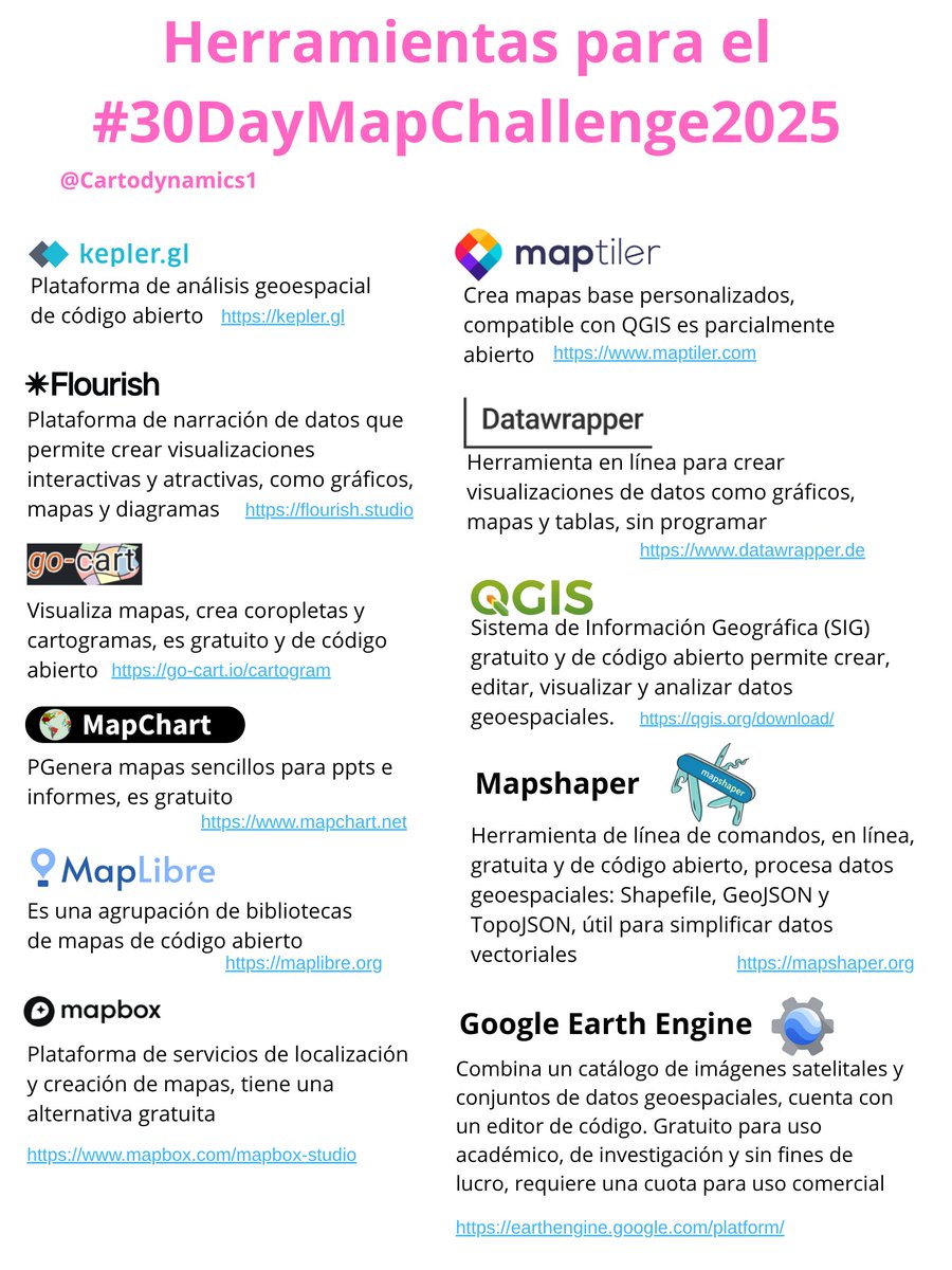
Se aproxima el #30DayMapChallenge, la idea es crear mapas con diferentes temas cada día de noviembre usando la etiqueta hashtag#30DayMapChallenge, hice una lista de herramientas para diseñar, visualizar y compartir mapas 🗺️💅🩵💻❤️🔥


United States Trends
- 1. Jonathan Taylor 19.6K posts
- 2. Falcons 30.5K posts
- 3. Colts 50.5K posts
- 4. Kyle Williams 4,798 posts
- 5. Daniel Jones 9,892 posts
- 6. Penix 10.7K posts
- 7. Parker Washington 2,580 posts
- 8. #Browns 2,112 posts
- 9. Jaxson Dart 2,826 posts
- 10. Joe Brady 1,366 posts
- 11. Dillon Gabriel 1,301 posts
- 12. #BillsMafia 5,357 posts
- 13. Liverpool 215K posts
- 14. Bijan 6,585 posts
- 15. Starks 1,854 posts
- 16. Max B 24.4K posts
- 17. #DawgPound 1,578 posts
- 18. #NYGiants 1,733 posts
- 19. Raheem 9,168 posts
- 20. Bubba Ventrone N/A


Something went wrong.
Something went wrong.